
5.1 The policies in this section apply across the whole District and are based on themes.
5.2 Sustainable development is the key principle underpinning the Three Rivers Core Strategy, and is critical to the delivery of many of the Council's and community's aspirations. It requires social progress which recognises the needs of everyone, effective protection of the environment, prudent use of natural resources and the maintenance of high and stable levels of economic growth and employment.
5.3 Particular priorities for sustainable development within Three Rivers are to:
5.4 All policies within the Core Strategy have been subject to Sustainability Appraisal to ensure sustainability in terms of economic, social and environmental impacts. In addition, a specific policy has been developed setting out the Council's approach to ensuring that new development will be sustainable.
5.5 Additional guidance on how development can maximise its sustainability and practical tips to meet policy requirements are provided by Building Futures: A Hertfordshire Guide to Promoting Sustainability in Development6.
5.6 In order to ensure that all development is sustainable the Council will require all development proposals to include a CPLAN Energy and Sustainability Statement'7. This is a web based checklist that gathers the energy and sustainability data of development applications and provides a consistent method of assessing the extent to which development accords with the sustainability objectives, policies and targets of the Core Strategy.
CP1 Overarching Policy on Sustainable Development |
All development in Three Rivers will contribute to the sustainability of the District. This means taking into account the need to:
Requirements for Applicants Applications for all new residential development of one unit and above and for all new commercial development will be required to submit a 'CPLAN Energy and Sustainability Statement'8 demonstrating the extent to which sustainability principles have been incorporated into the location, design, construction and future use of proposals, and the expected carbon emissions. Applicants should demonstrate that their development will produce at least 25% less carbon dioxide emissions than Building Regulations Part L (2006) requirements with a minimum of 10% being provided by on-site renewable and/or low carbon (i.e. Combined Heat and Power) energy supply systems. In line with Government policy, where it can be proven that on-site renewable technology is not feasible, the Council will consider connection to a local, decentralised, renewable or low carbon energy supply as a substitute for on-site renewable energy technology. The Council will set higher targets for carbon reduction and energy contributions from renewable sources in future in line with the Government's target for all new homes to be zero carbon by 2016 and non-domestic developments to be zero carbon by 2019. These targets will be set out in the forthcoming Development Management Policies Development Plan Document and will be informed by changes to national policy, the Council's Sustainability Action Plan9 and the Low and Zero Carbon Study10. Development will not be permitted unless it is demonstrated that sustainable development principles are satisfied through compliance with the policies of this Core Strategy and other relevant regional and national policy requirements. |
5.7 Providing sufficient housing to meet the needs of local communities in a sustainable way is one of the key challenges facing Three Rivers. Development in the District needs to:
5.8 The East of England Plan requires Three Rivers to accommodate 5,000 dwellings between 2001 and 2026, an average of 200 dwellings per year. The Council has considered available evidence both on the need for housing in the District and the capacity of the District to accommodate this need. The Council considers that it is appropriate for Three Rivers to provide 4,500 dwellings between 2001 and 2026, a target of 180 homes per year. The Council expects that housing requirements will be met through dwellings already completed, dwellings under construction and with planning permission, sites to be identified through the Site Allocations Development Plan Document and unidentified sites from within the existing urban areas (windfalls).
5.9 The current housing supply situation and progress towards meeting the Three Rivers housing target is set out in Table 1.
Table 1: Progress Made in Meeting Three Rivers Housing Targets11
| Three Rivers Housing Target 2001-2026 | 4,500 dwellings |
| Net Completions 2001-2010 | 1,974 dwellings |
| Sites Under Construction | 191 dwellings |
| Sites with Full Planning Permission | 358 dwellings |
| Sites with Outline Planning Permission | 20 dwellings |
| Total Supply | 2,543 dwellings |
| Number of Houses that Need to be Found Land for | 1,957 dwellings |
5.10 It will therefore be necessary to identify land for at least 1,957 dwellings. The majority of housing supply between 2001-2026 is expected to come from within existing urban areas. However evidence from the Strategic Housing Land Availability Assessment Update (2010)12 shows that there will not be sufficient housing capacity within existing urban areas towards the middle and end of the Plan period, but that there is potential to meet housing targets from sites both within urban areas and on the edge of urban areas.
5.11 Specific sites will be identified through the Site Allocations Development Plan Document. Identification will be in accordance with the Spatial Strategy and will be informed by the evidence base, the results of public consultation, and detailed criteria for the selection of housing sites as shown in Appendix 2.
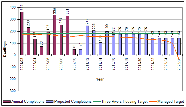
5.12 Table 2 and Figure 6 show the Three Rivers housing trajectory. This is a forecast of how we plan to meet housing targets to 2026. The trajectory will be updated annually through the Annual Monitoring Report.
5.13 Figures for 2001-2016 are based on monitoring information and the five year land supply assessment required by Planning Policy Statement 3: Housing13.
5.14 Beyond 2016, the Strategic Housing Land Availability Assessment Update (2010) and other evidence base information are used to project the expected proportions of sites within existing urban areas and sites on the edge of existing settlements.
5.15 In line with national policy, the housing trajectory does not include an allowance for sites that have not been identified (windfalls) coming forward in the first ten years from anticipated adoption of the Core Strategy, although it is acknowledged that these will make a contribution to housing supply in the District. Any windfalls that do come forward will be taken account of through the Annual Monitoring Report and will be counted as part of our housing supply. This will include updates to the assessment of five year land supply which will determine if and when Green Belt housing sites need to be released to meet housing requirements.
5.16 Beyond 2021, a windfall allowance has been included in the trajectory. This is on the basis that historically, conversions of between one and four houses into flats and newbuild of one or two dwellings have contributed an average of 38 dwellings a year to housing supply.
5.17 In relation to windfalls, it was not possible for the Strategic Housing Land Availability Assessment and Update to determine which houses or small pieces of land within the District will be deliverable for housing within the Plan period as this is dependent on owners' intentions. It was also not realistic to contact all owners in the District to establish whether they would consider making their land/ property available for development and to establish for each possibility whether housing would be deliverable here.
5.18 As monitoring data has shown that supply from windfalls has come
from across the whole District (rather than concentrated in certain
areas), it has not been possible to identify broad locations where this
source is likely to contribute, further than 'within the existing urban
area'.
5.19 A windfall allowance of 38 dwellings a year has therefore been
included within the trajectory and is considered to be reasonable and
realistic. It reflects the difficulty of identifying suitable land for
development within the District which is highly constrained. The windfall
allowance will be monitored annually and revised as appropriate through
the Annual Monitoring Report and housing trajectory updates.
Table 2: Three Rivers Housing Trajectory at April 201014
|
2001/02 |
2002/03 |
2003/04 |
2004/05 |
2005/06 |
2006/07 |
2007/08 |
2008/09 |
2009/10 |
2010/11 |
2011/12 |
2012/13 |
2013/14 |
2014/15 |
2015/16 |
2016/17 |
2017/18 |
2018/19 |
2019/20 |
2020/21 |
2021/22 |
2022/23 |
2023/24 |
2024/25 |
2025/26 |
a) Three Rivers Housing Target |
180 |
180 |
180 |
180 |
180 |
180 |
180 |
180 |
180 |
180 |
180 |
180 |
180 |
180 |
180 |
180 |
180 |
180 |
180 |
180 |
180 |
180 |
180 |
180 |
180 |
b) Cumulative Three Rivers Housing Target |
180 |
360 |
540 |
720 |
900 |
1080 |
1260 |
1440 |
1620 |
1800 |
1980 |
2160 |
2340 |
2520 |
2700 |
2880 |
3060 |
3240 |
3420 |
3600 |
3780 |
3960 |
4140 |
4320 |
4500 |
c) Completions |
365 |
233 |
138 |
73 |
197 |
335 |
254 |
331 |
48 |
|
|
|
|
|
|
|
|
|
|
|
|
|
|
|
|
d) Sites under construction |
|
|
|
|
|
|
|
|
|
70 |
80 |
41 |
|
|
|
|
|
|
|
|
|
|
|
|
|
e) Sites with planning permission |
|
|
|
|
|
|
|
|
|
-21 |
152 |
127 |
99 |
24 |
|
|
|
|
|
|
|
|
|
|
|
f) Sites within Existing Urban Areas |
|
|
|
|
|
|
|
|
|
|
15 |
38 |
7 |
75 |
70 |
75 |
75 |
75 |
75 |
75 |
45 |
45 |
45 |
45 |
45 |
g) Sites on the Edge of Existing Settlements |
|
|
|
|
|
|
|
|
|
|
|
|
|
100 |
102 |
100 |
100 |
100 |
100 |
100 |
60 |
60 |
60 |
60 |
60 |
h) Windfall Allowance |
|
|
|
|
|
|
|
|
|
|
|
|
|
|
|
|
|
|
|
|
38 |
38 |
38 |
38 |
38 |
i) Provision (sum of c to h) |
365 |
233 |
138 |
73 |
197 |
335 |
254 |
331 |
48 |
49 |
247 |
206 |
106 |
199 |
172 |
175 |
175 |
175 |
175 |
175 |
143 |
143 |
143 |
143 |
143 |
j) Cumulative Completions |
365 |
598 |
736 |
809 |
1006 |
1341 |
1595 |
1926 |
1974 |
2023 |
2270 |
2476 |
2582 |
2781 |
2953 |
3128 |
3303 |
3478 |
3653 |
3828 |
3971 |
4114 |
4257 |
4400 |
4543 |
k) Cumulative Shortfall/ Over Provision (j-b) |
185 |
238 |
196 |
89 |
106 |
261 |
335 |
486 |
354 |
223 |
290 |
316 |
242 |
261 |
253 |
248 |
243 |
238 |
233 |
228 |
191 |
154 |
117 |
80 |
43 |
Figure 6: Three Rivers Housing Trajectory at April 2010
CP2 Housing Supply |
The Council will identify sufficient land for housing in the District to meet the Three Rivers housing target of 180 dwellings per year until 2026. Housing provision will be made primarily from within the existing urban area (approximately 75% of total housing development between 2001-2026) and also from housing sites at the most sustainable locations on the edge of existing settlements, in the Green Belt (approximately 25% of total supply between 2001-2026). It is anticipated that approximately 60% of housing requirements will be met in the Key Centres as defined in the settlement hierarchy. This is likely to be achieved in part through significant mixed use development at Leavesden Aerodrome and through regeneration in South Oxhey. Specific sites will be identified through the Site Allocations Development Plan Document according to the policies and parameters set out in the Core Strategy and in accordance with the Spatial Strategy and Place Shaping Policies. In identifying sites for future development, the Site Allocations Development Plan Document will set out an indicative phasing strategy for the development of sites. This strategy will take into account the policies and parameters established through the Core Strategy and will take into account the sustainability of each site, the deliverability of housing on the site and likely infrastructure requirements. Sites which contribute better to sustainability objectives, are deliverable, and will not have infrastructure requirements that will require a long lead-in time will be phased earlier than sites that contribute less well to sustainability objectives, are not deliverable in the shorter term or require a lead-in period for infrastructure provision. The Annual Monitoring Report will set out the latest information on housing supply, including an assessment of whether there is a deliverable five-year supply of land for housing. The phasing strategy for sites will be reviewed annually as part of the Annual Monitoring Report process. Indicative phasing of sites may be altered having regard to the Annual Monitoring Report and up-to-date information on the delivery of specific sites. This may result in sites coming forward and/or sites being set back over the Plan period. The earlier release of identified edge of settlement sites in the Green Belt will only be considered if:
Amended sites will form part of the housing supply, and the housing trajectory will be adjusted accordingly. This ensures that there will be flexibility to respond to changing conditions and that there is a continuous supply of deliverable land for housing. It will also allow the delivery of infrastructure alongside new housing development, ensuring that there is not an undue burden on services and infrastructure to the detriment of existing and new householders. The supply of housing post-2026 will need to be reassessed at a later date within the context of a review of the Core Strategy taking into account housing needs and capacity. In assessing applications for development not identified as part of the District's housing supply including windfall sites, the Council will have regard to policies and parameters set out in the Core Strategy. Applications will be considered on a case by case basis having regard to:
|
5.20 In order to meet future housing needs in Three Rivers, the overall housing requirement will need to be provided as a range of housing types and sizes. Providing a balance of housing will help meet the varied needs of the community and contribute to sustainability objectives.
5.21 The Strategic Housing Market Assessment (2010) provides information on the current and future housing needs of the District. The study found that:
5.22 The Assessment also looks at housing mix in terms of size of accommodation. The assessment indicates that need in the District to 2021 is for approximately:
5.23 These proportions should form the basis for the housing mix of development proposals and provision across the District. However it is recognised that they may need to be adjusted for specific schemes to take account of market information, housing needs and preferences and specific site factors. Where adjustment to the proportions is sought, applications should explain how relevant factors have contributed to the mix of housing proposed.
5.24 With regard to housing density, the Council acknowledges that, whilst it is important to make more efficient use of land, particularly to reduce pressure on greenfield sites, this should not compromise the quality of the environment and existing residential areas in Three Rivers, some of which may fall within areas of special landscape or historic value.
CP3 Housing Mix and Density |
The Council will promote high quality residential development that respects the character of the District and caters for a range of housing needs. Development will make the most efficient use of land, without compromising the quality of the environment and existing residential areas. The Council will require housing proposals to take into account the range of housing needs, in terms of size and type of dwellings as identified by the Strategic Housing Market Assessment and subsequent updates. New development will also provide a range of house types and sizes to reflect the existing and future needs of the Three Rivers population and the characteristics of housing in the area. This includes provision of housing for the elderly and supported and specialist accommodation which will be encouraged in suitable and sustainable locations. Until guidance as part of an overall Design Guide Supplementary Planning Document is produced, the density of development will be considered on its merits taking into account the need to:
|
5.25 Average house prices in the District are some of the highest in the country outside London. As a result, many local people have difficulty in accessing housing on the open market. This particularly affects the young and those on lower incomes who are entering the housing market. Improving the supply and standard of affordable housing is therefore one of the priorities of the Community Strategy.
5.26 Affordable housing includes:
5.27 Low cost market housing is not included within the Government's definition of affordable housing.
5.28 The East of England Plan sets a target that 35% of all new residential units delivered in the region will be affordable. However, evidence shows that the need for affordable housing in the local area is very high. The Housing Needs Study (2004 update) estimated that 429 affordable dwellings would be needed each year to satisfy need. Such provision would exceed the total number of all housing types provided in the District in any year.
5.29 The Council has undertaken a more up-to-date assessment of need through the Strategic Housing Market Assessment in partnership with some of the Hertfordshire authorities in the London Commuter Belt Sub-Region. The Strategic Housing Market Assessment (2010) provides a thorough assessment of current and future housing markets and needs and the housing requirements of specific groups.
5.30 The key findings from the Assessment are that:
5.31 While in overall terms, the evidence shows that there is a greater need for intermediate housing, the most urgent need within Three Rivers is for social rented affordable housing as demonstrated by the Housing Register. Providing social rented housing is therefore the priority for the District.
5.32 When considering the level and type of affordable housing requirements, it is also important to take into account economic viability considerations.
5.33 In terms of viability, the Council has also undertaken a Development Economics Study in partnership with adjoining authorities. This study assessed the economic viability of land for housing within the area, taking account of risks to delivery and likely levels of finance available for affordable housing, including public subsidy and the level of developer contribution that can reasonable be secured.
5.34 The study found that the viability of a site can vary across the District depending on:
5.35 The Study concludes that on average a 45% overall target for affordable housing from future housing developments across the District is achievable. It is recommended that a flexible approach be taken on a site-by-site basis, with greater amounts being sought in some higher value areas and lower amounts in lower value areas.
5.36 It also recommends that the site threshold at which targets are sought should be set at one unit to enable small sites to contribute towards affordable housing provision in the District. In the case of small sites (between one and nine dwellings) it indicates that as an alternative to on-site provision, there is a role for the requirement of commuted payments towards provision off site.
5.37 Monitoring information indicates that the majority of housing sites coming forward in recent years are for relatively small developments (just 7% of sites given planning permission for new housing development in 2007/08 were for sites of 15 or more units).
5.38 It is clear from the evidence therefore that, in order to ensure affordability in the District in any meaningful way, a step-change in policy approach and affordable housing delivery is required. This means adopting a low site threshold at which affordable housing is sought as a part of development and increasing the percentage of affordable housing as a proportion of all housing on a site.
CP4 Affordable Housing |
In order to increase the provision of affordable homes in the District and meet local housing need as informed by the Strategic Housing Market Assessment, the Council will:
In assessing affordable housing requirements including the amount, type and tenure mix, the Council will treat each case on its merits, taking into account site circumstances and financial viability. In calculating the percentage of affordable units to be provided as part of a development scheme, the affordable housing requirement will normally be 'rounded up' to the nearest whole number. |
5.39 Where non-viability is cited as the reason for a development proposal not complying with affordable housing requirements, applicants for planning permission must support this reason with financial evidence to be submitted alongside the planning application.
5.40 The Council will produce further guidance on the provision of affordable housing in the District, in the form of an Affordable Housing Supplementary Planning Document. This will include guidance on the calculation of commuted payments from small sites and the role and use of such funds in the Council's wider housing strategy. It will be regularly updated, taking into account the findings from new research and monitoring information.
5.41 Gypsy and Travellers and Travelling Showpeople have particular accommodation needs that require additional consideration. To ensure that members of these communities are able to access decent and appropriate housing, the Council must make provision for accommodation to meet identified needs.
5.42 The Regional Strategy sets out a target for Three Rivers to provide 15 additional pitches for Gypsies and Travellers by 2011 and a further 13 pitches by 2021. Since 2006, 15 pitches for Gypsies and Travellers have been provided through the grant of planning permission. The Council will allocate sites to meet the regional target in the Gypsy and Traveller DPD in accordance with Policy CP5. The Council acknowledges a need for 10 transit pitches in south and west Hertfordshire to complement the existing South Mimms site by 2011 and will work with neighbouring authorities to identify the most appropriate location(s) for these pitches. There is not considered to be a need for any additional plots for travelling showpeople in the District. These targets will be kept under review.
5.43 A pitch is an area of land where a Gypsy or Traveller household can reside. It typically consists of a building, a parking space and one or more caravans. The average number of caravans per pitch is currently estimated as 1.7. However this may vary depending on the size of individual families, their particular needs and the extent to which facilities are shared. A site is an area of land comprising multiple pitches and, where appropriate, communal facilities.
5.44 Any applications for pitches will be assessed on a case by case basis against the policies of the Core Strategy and other relevant guidance.
5.45 In considering the circumstances of the applicant and their need for pitches on the application site, factors which may be taken into account include (but are not limited to) family and cultural ties, employment, health and education requirements.
CP5 Gypsy and Traveller Provision |
When allocating sites or considering planning applications for sites for Gypsies and Travellers or Travelling Showpeople, a criteria based approach will be used. The following criteria will be taken into account:
|
5.46 In order to maintain and improve the economic performance of the District, it is important to make provision for future employment and economic development alongside housing growth and protection of the environment. To provide a balance between homes and jobs, economic growth should be in broad alignment with housing development.
5.47 Economic development includes development within the B Use Classes, public and community uses, leisure and tourism uses and main town centre uses. It also includes any other development which provides employment opportunities, generates wealth or produces or generates an economic output or product. It does not include housing development.
5.48 The economy of south-west Hertfordshire (Three Rivers, Watford and Dacorum) is dominated by service industries such as those associated with motor vehicles sales and maintenance, computing, post and telecoms, construction, printing and publishing. These are the areas which offer the greatest opportunity for economic growth in the south-west Herts area in future. Three Rivers is particularly attractive to small businesses often relocating from London, and to film and media (as illustrated at Leavesden Aerodrome).
5.49 The influence of surrounding areas on the economy of Three Rivers is significant. This is demonstrated for example by the high levels of out-commuting from the District, reflecting proximity to the London job market and to other larger centres such as Watford and Hemel Hempstead.
5.50 In accordance with Planning Policy Statement 4: Planning for Sustainable Economic Growth, to complement work at the regional level, including the East of England Plan and the Regional Economic Strategy more local evidence has been used to inform the detailed requirements for land or floorspace for economic development over the plan period.
5.51 The Employment Land Study (2005) undertaken for the Districts in south-west Hertfordshire indicated that on the basis of projected growth within the area, Three Rivers cannot afford to lose any more employment floorspace within the industrial and warehousing sectors. There was however a projected over supply of offices within Three Rivers, largely as a result of existing commitments at Leavesden Aerodrome.
5.52 The Study also identified the need to retain an element of employment land in the District in order to keep a check on existing high levels of out-commuting by Three Rivers residents. There also continues to be a demand for small and medium sized units for all types of employment and it remains important to protect and provide these types of units.
5.53 A further study with other Hertfordshire authorities within the 'London Arc' was undertaken to assess the implications of the jobs growth targets which were contained within the Regional Spatial Strategy in term of land-use and employment sites within the District to 2026.
5.54 Findings indicate that Three Rivers should make provision for 2,378 additional jobs between 2006-2026. This can be broken down into Business Class activities such as offices, factories and warehousing (1,568 jobs) and non-Business Class activities such as hotels and catering, transport and communications, retailing, education and health (810 jobs).
5.55 Across the Arc area there is evidence that the office market is affected by slow demand for space and that there is likely to remain an over supply of offices in the District, largely due to poor take up of space at Leavesden Aerodrome. The demand for industrial/warehousing is likely to remain particularly in relation to 'Smart Sheds' (high quality, flexible business space) and 'Secondary Sheds' (smaller, lower value, industrial space). The demand for 'Logistics/Big B8 sheds' (very large warehousing space) is also likely to remain in the area.
5.56 Taking into account business job growth and the likely demand and supply for employment space, the London Arc Study predicts how much land is likely to be required in each district up to 2026. This can be broken down into offices and general industrial/ warehousing:
5.57 Building on the Employment Land Study (2005) and the London Arc Study (2009), an Employment Land Study Update (2010) has been undertaken for Three Rivers and Dacorum councils to consider the quantity, mix and geographical spread of employment land that should be provided in each District. The Study recommends that authorities should continue to use the London Arc land provision targets.
5.58 For Three Rivers, the Study broadly reflects the findings of earlier studies and considers that:
5.59 The study will be used to inform the Site Allocations DPD in relation to the identification of specific employment sites within the context of other competing land uses such as residential and employment provision within neighbouring areas.
CP6 Employment and Economic Development |
The Council will support development that:
The sustainable growth of the Three Rivers economy will be supported by:
The Site Allocations Development Plan Document will identify sites for additional employment floorspace and the boundaries of designated employment areas. It will also identify sites with the potential to accommodate mixed use development according to the principles set out in this policy. On the basis of current evidence, this is likely to include the introduction of residential and other uses at Leavesden Aerodrome, Kings Langley employment area and Delta Gain, and expansion of business activity at Maple Cross. These sites are indicated on the Key Diagram (Figure 5). |
5.60 Centres within Three Rivers play an important role in supporting local communities by providing for day to day needs and contributing to the economy of the District. There is competition between centres and with larger nearby town centres at Watford, Hemel Hempstead and St Albans but thriving, vibrant and attractive town, district and local centres are important to help meet local needs of Three Rivers communities.
5.61 Watford, Hemel Hempstead and St Albans are likely to remain the primary destination for Three Rivers residents for comparison goods and should be the focus for provision of higher order retail, leisure and other services. However, the centres in Three Rivers will continue to provide an important function in meeting all types of local needs, and reducing the need to travel.
5.62 To support the management and growth of town centres and shopping, a hierarchy of centres setting out the role and relationships of centres in the area has been identified. The hierarchy is set out in Figure 7, and centres are illustrated in Appendix 3 which shows their size and relative importance.
Town Centre |
||
Rickmansworth Town Centre – the principal shopping and service centre in Three Rivers containing a range of facilities and services, serving a District-wide catchment area. |
||
District Centre |
||
South Oxhey |
} |
centres comprising a varied but more limited range of shops and services and serving a smaller catchment area. |
Local Centres |
||
Croxley Green (Watford Road)
|
} |
smaller centres serving more local needs. |
Local Shops |
||
A range of local shopping parades, groups or individual shops distributed throughout the District normally serving very local convenience needs. |
||
Figure 7: Hierarchy of Retail Centres
5.63 The Town, District and Local centres provide essential services for local communities and can help reduce the need to travel by providing retail, community facilities and a range of services, as well as local employment opportunities.
5.64 Although variety and provision is more limited, local shops or services, particularly in villages, also play an important role in maintaining sustainable communities.
5.65 Each centre can be further broken down by area according to the level of retail activity and importance within those areas. The larger centres contain both 'Primary' and 'Secondary' frontages; Primary frontages are generally located within the core parts of the centres, with Secondary frontages on the edges. Retail centre boundaries and the Primary and Secondary shopping frontages within these will be considered and allocated through the Site Allocations Development Plan Document.
5.66 The quality of shopping provision in the District is generally good, although the Council is aware that some centres need environmental enhancements to maintain and/or improve the appearance and vitality of local shopping centres across the District. Recent enhancements have been made to Tudor Parade, Mill End and Baldwins Lane, Croxley Green. The Council will continue with its programme of enhancements to retail parades.
5.67 It is necessary to provide sufficient sites to meet identified needs for town centre uses and to meet local day-to-day needs. The Retail Capacity Study (March 2007) has assessed the need to plan for additional retail floorspace within Three Rivers over the coming years.
5.68 On the basis of projected expenditure by shoppers, the ability of existing centres to retain and attract shoppers (market shares) and the population changes anticipated up to 2021, the Study found two main conclusions for the District as a whole:
CP7 Town Centres and Shopping |
Where there is an identified need for new town centre development, Town and District centres will be the focus for this development. Retail development will specifically be directed to within the Primary Frontages of these centres. Proposals for new town centre and shopping development will be considered taking into account:
The hierarchy of retail centres and their established character and diversity will be maintained through:
Projected increases in expenditure and population will be accommodated and should be spread between all centres so that each becomes increasingly self-sufficient in the provision for day-to-day needs, so reducing the need to travel. This means providing additional comparison (non-food) floorspace, equating to a net gain of around 2,000 square metres by 2021. The target provision over forthcoming five-year periods will be broadly as follows:
These targets will be reviewed regularly and amended in light of new evidence in relation to forecast expenditure and population. Proposals that would result in provision over and above these targets will be considered on their merits taking into account their appropriateness in scale and function to the relevant centre. With regard to convenience (food) shopping:
|
5.69 The timely provision of infrastructure, to ensure that existing and new communities are able to access services that they require and minimise the need to travel is a key component in the delivery of the Spatial Strategy and ensuring the sustainability of the District.
5.70 Infrastructure covers a range of services and facilities and may include social infrastructure (such as health, education, community, leisure and cultural and faith facilities), physical infrastructure (such as transport and utilities) and Green Infrastructure (such as parks and open spaces). Green Infrastructure and infrastructure for transport and travel are key components of infrastructure provision and are dealt with in more detail under Core Policy 9 and Core Policy 10.
5.71 Planning for infrastructure requires joint working with infrastructure providers in both the public and private sector to ensure delivery. Ongoing dialogue with infrastructure providers, such as the Local Strategic Partnership and utility companies, is essential to plan for infrastructure needs and help shape the District. The Local Development Framework plays a key role in co-ordinating provision to ensure that it meets current and future demands.
5.72 There is concern in the District that in the past, provision of infrastructure has not kept pace with new development, leading to communities experiencing difficulty in accessing the services and facilities they need.
5.73 To support the delivery of the Core Strategy in Three Rivers and ensure that future development does not create more problems for communities in accessing services, an Infrastructure Delivery Plan has been produced15. This plan establishes what additional infrastructure is required to support the planned increase in new homes and jobs and the projected population growth in the District up to 2026. The Plan is informed by the Hertfordshire Infrastructure and Investment Strategy which provides a strategic view of infrastructure provision across Hertfordshire.
5.74 The Infrastructure Delivery Plan is accompanied by an Infrastructure Delivery Schedule. This is included in the Core Strategy as Appendix 4, and will be updated annually through the Annual Monitoring Report reflecting changes to both requirements and provision.
5.75 The Infrastructure Delivery Plan provides the basis for planned investment in infrastructure, including contributions from developers through Section 106 agreements or any future Community Infrastructure Levy. More detailed work will be required to establish appropriate charging regimes.
5.76 The Infrastructure Delivery Plan also highlights where there may be a need to allocate land required for infrastructure through the Site Allocations Development Plan Document.
5.77 The Council negotiates with developers, through the use of planning obligations, to contribute towards infrastructure as part of relevant development proposals. This includes:
5.78 Hertfordshire County Council is responsible for negotiating planning
obligations with developers in respect of contributions to the following
areas:
5.79 The Council will continue to work with the County Council and infrastructure providers to ensure that sufficient infrastructure is provided.
5.80 Contributions to other forms of infrastructure, for example to make provision for health facilities, policing, utilities including water supply, waste water capacity and gas and electricity supply or for the enhancement of heritage assets may also be required depending on the scale, location and type of development.
5.81 In relation to utilities infrastructure the Council will seek to ensure that there is adequate capacity to serve all new developments. In some circumstances this may make it necessary for developers to carry out appropriate studies to ascertain whether the proposed development will lead to overloading of existing infrastructure. Where there is a capacity problem and no improvements are programmed by statutory undertaker, the Council will require the developer to fund appropriate improvements which must be completed prior to occupation of the development.
5.82 In dealing with infrastructure and all other requirements that are necessary to enable development to proceed, the Council will seek to enter into planning obligations with developers to address site specific issues related to the form and type of development.
5.83 The type and scale of infrastructure required, or in some cases a contribution towards it, will continue to be determined on a case-by-case basis using guidance and formulae. For example, contributions towards open space, amenity and children's play facilities are set out in the Council's Supplementary Planning Document (SPD). Contributions that are sought by the County Council are calculated using the Hertfordshire 'Toolkit' guidance document (2008). This is based on a tariff approach and contributions are calculated on a property-by-property basis.
5.84 The Community Infrastructure Levy will be a new charge which local authorities will be empowered but not required to charge on most types of new development. The proceeds of the Levy will be spent on local and sub-regional infrastructure to support the development of the area. Local authorities have the option to use the Community Infrastructure Levy from April 2010.
5.85 An Infrastructure and Obligations Supplementary Planning Document will be produced setting out further guidance on the key infrastructure requirements for the District, how and when contributions will be sought and how levels of contributions will be determined.
CP8 Infrastructure and Planning Obligations |
Development will provide, or make adequate contribution towards, infrastructure and services to:
In relation to utilities infrastructure (water supply, waste water capacity, electricity supply and gas supply), developers will be required to demonstrate that:
Infrastructure provision will take full account of the Council's priorities for infrastructure, services and facilities, including those identified in the Infrastructure Delivery Plan and Infrastructure Delivery Schedule. This will contribute to the infrastructure necessary to support growth in the area. We will continue to work in partnership with the County Council and other Districts to develop a Community Infrastructure Levy (CIL). In the meantime and in the event that CIL is not progressed the Council will continue to use existing procedures and arrangements in relation to developer contributions. These include standard charges and formulae to calculate indicative contributions and to seek on-site provision of the required facilities each time a dwelling or commercial site is developed. Detailed charges and formulae are set out in the Council's supplementary planning documents (for example 'Open Space, Amenity and Children's Play Facilities, 2007) and other guidance documents as appropriate including Hertfordshire County Council's 'Planning Obligations Guidance – Toolkit for Hertfordshire' (2008). Further guidance will also be set out in future Infrastructure and Obligations Supplementary Planning Document and Green Infrastructure and Landscape Supplementary Planning Document. Applications for development will be considered on a case-by-case basis to allow individual site circumstances to be reflected where appropriate. |
5.86 Green Infrastructure refers to networks of green spaces and natural elements, including open spaces, waterways, gardens, woodlands, green corridors, wildlife habitats, street trees, natural heritage, heritage assets, earth science interests and open countryside. It provides for multi-functional uses, for example providing landscape, wildlife, recreational and cultural experiences, and can play a key role in adapting to and mitigating climate change, including through the provision of Sustainable Drainage Systems. The Council will plan for Green Infrastructure in partnership with neighbouring local authorities, the County Council, relevant interest groups and landowners.
5.87 Green Infrastructure can support existing and new communities and provides multiple benefits for the economy, the environment and people, and should be planned, delivered and managed in a coordinated and consistent manner across the District with an appropriate level of investment to promote these benefits. Green Infrastructure may particularly provide opportunities for biodiversity gain by linking habitats and creating corridors allowing response to climate change.
5.88 The aim in planning for Green Infrastructure is to create, extend and enhance existing linked networks, whilst ensuring appropriate management and maintenance.
5.89 Green Infrastructure is important at all scales. It will inform the Site Allocations Development Plan Document and will be considered in assessing applications for new development.
5.90 The Council has conducted an Open Space Study Update (2010)16 and has produced a Green Infrastructure background paper (2010) which identifies the key assets for Green Infrastructure in the District, existing and potential linkages between these and links to surrounding areas. These assets are illustrated in Appendix 5.
5.91 The key Green Infrastructure assets in Three Rivers include:
5.92 These are important Green Infrastructure assets within the District into which other assets link through the identified Green Infrastructure corridors. However, these are not the only important elements for Green Infrastructure within and around the District, and open spaces, woodlands and other spaces may also be significant.
5.93 The Council is working with the County Council and Natural England to produce a suite of compatible district-scale plans in parallel with a county plan that highlights strategically important Green Infrastructure, and a more detailed local strategy taking into account standards for accessible open and green space. These will inform the production of a Green Infrastructure and Landscape Supplementary Planning Document which will also include an updated landscape strategy for the District.
5.94 The Infrastructure Delivery Plan and Schedule includes some specific schemes that will contribute to Green Infrastructure in the District. These will be updated annually through the Annual Monitoring Report.
CP9 Green Infrastructure |
The Council will seek a net gain in the quality and quantity of Green Infrastructure, through the protection and enhancement of assets and provision of new green spaces. Priorities for Green Infrastructure focus on conserving and enhancing the following key assets and the linkages between them which are illustrated in Appendix 5:
It is also important to improve connectivity between key assets through the establishment of linked and coherent networks and corridors of green spaces and sustainable transport links. More detailed ongoing work will inform future priorities for Green Infrastructure in Three Rivers and will be included within the Green Infrastructure and Landscape Supplementary Planning Document. The Council will require new development to contribute to the delivery of new Green Infrastructure and the management of a linked network of new and enhanced open spaces and corridors. Development will not compromise the integrity of the Green Infrastructure network, by causing fragmentation, damage to, or isolation of Green Infrastructure assets including natural habitats and species. |
5.95 The Government's priorities for transport set out in Planning Policy Guidance 13: Transport and Planning Policy Statement 1: Delivering Sustainable Development are to promote more sustainable transport choices, to promote access and to reduce the need to travel.
5.96 Three Rivers is well served by communication links. However, car ownership levels are high and car usage increasingly dominates patterns of movement in the District. Traffic levels in the District are forecast to grow by 21% by 2021. Increased congestion and car use could undermine the economic growth of the District and harm the quality of the environment and social well-being.
5.97 Meeting the transport needs of Three Rivers effectively is of paramount importance in delivering the Core Strategy's Spatial Strategy and contributing to the sustainability of the District. The Infrastructure Delivery Plan identifies specific transport schemes that will contribute to meeting transport needs and the sustainability of the District, including transport infrastructure necessary to deliver the levels of growth required in the District. Transport needs have been identified through the Local Transport Plan 2006/07-20011/12, the South West Herts Transportation Strategy (2004 and updated as South West Herts Transportation Plan 2008), the Bus Network Strategy Review (2006), Intelligent Transport Systems Strategy (2008), The Hertfordshire Infrastructure and Investment Strategy (2009) and responses to public consultation. They are illustrated in Appendix 6.
5.98 While Three Rivers District is not responsible for the transport network, the location of new development may have a significant impact on the transport and travel network and on travel choices. The Spatial Strategy seeks to direct development to the areas with greatest access to public transport, services and facilities, which should contribute to reducing the need to travel and journey lengths, and enable the use of public transport, walking and cycling as alternatives to the car.
5.99 The Council will also work with Hertfordshire County Council, the Highways Agency and other transport providers to provide a co-ordinated and enhanced transport system which improves connectivity and transport services to and between settlements within Three Rivers, to town centres in surrounding areas, and to London. In this context, important projects include the Croxley Rail Link, Watford Junction improvements and the Watford Health Campus.
CP10 Transport and Travel |
The Council will promote transport measures identified in the Infrastructure Delivery Plan in partnership with Hertfordshire County Council, the Highways Agency and transport providers. Development proposals will be expected to contribute to the delivery of transport and travel measures identified as necessary for the development, either on-site as part of the development or through contributions to off-site provision as appropriate. Provision for interchange and access by public transport, walking and cycling will be regarded as particularly important. Every opportunity will need to be taken to integrate means of travel. The following transport and travel measures will be supported at appropriate locations across the District, and development will need to consider the provision of measures and facilities that encourage integration including:
The transfer of road freight to railways and canals in the District will be supported in principle, subject to the provision of a full Transport Assessment and the provisions of all other relevant local, regional or national policies, including an assessment of impact on the environment and amenity. Development proposals All development should be designed and located to minimise the impacts of travel by motor vehicle on the District. In particular, major development will be expected to be located in areas highly accessible by the most sustainable modes of transport, and to people of all abilities in a socially inclusive and safe manner, in accordance with the user hierarchy below. Priority will be given in the following order:
Development will need to demonstrate that:
|
5.100 Matters relating to operational car parking and standards will be covered within the Development Management Policies Development Plan Document. Until standards are reviewed, the Council will continue to apply existing standards in accordance with the saved policies of the Three Rivers Local Plan. Further guidance on transport issues for development is included in the 'Manual for Streets' and 'Roads in Hertfordshire' design guides.
5.101 Green Belt designation covers 77% of the area of Three Rivers. The fundamental aim of the Green Belt is to prevent urban sprawl by keeping land permanently open. Within the Green Belt, there is a general presumption against inappropriate development which should not be approved except in very special circumstances.
5.102 The East of England Plan aims to reconcile growth in the region with the protection of the environment and the general extent of the Green Belt. It does not identify Three Rivers as an area requiring strategic review of the Green Belt. Protection of the Green Belt and open countryside is a key objective of the Three Rivers Core Strategy. However, the Green Belt boundary is tightly drawn around urban areas, and local evidence has demonstrated that future development needs cannot be accommodated entirely within the urban area.
5.103 Therefore, as set out in the Spatial Strategy, while the main focus for development in the District will be the main urban areas, there is also a need for some minor adjustments to the Green Belt boundary to accommodate growth in the most sustainable locations on the edge of existing settlements. Boundary changes are expected to provide land for housing and employment development and may also provide land for one or possibly two new reserve secondary school sites in the Rickmansworth Area, depending on the outcome of Hertfordshire County Council work on the potential to expand existing secondary school provision in the South West Hertfordshire area.
5.104 Detailed changes to the established Green Belt boundary will be made through the allocation of land for development by the Site Allocations Development Plan Document and are anticipated to result in a loss of no more than 1% of the area designated as Green Belt in the District. This is expected mainly as a result of new housing development on the edge of settlements in accordance with the Spatial Strategy.
5.105 While future development needs may require adjustment of Green Belt boundaries, the Local Plan also identifies two Major Developed Sites in the Green Belt at Leavesden Aerodrome and Maple Lodge Sewage Treatment Works. This designation acknowledges that development in these areas may be necessary over the Plan period for strategic and operational reasons. In this regard Major Developed Site in the Green Belt status for Maple Lodge Sewage Treatment Works will be retained.
5.106 With regard to Leavesden Aerodrome, the Council recognises the importance of the site in meeting future housing and employment needs as shown by the recent planning application to extend Leavesden Studios and previous public consultation on allocating housing development at the site. The Major Developed Site in the Green Belt status currently limits the scope to achieve both the extension to the Studios and development for housing and associated community uses. Therefore in order not to compromise the ability of the site to contribute to future development needs, the Council will review the Green Belt designation and Major Developed Site status as part of the Site Allocations Development Plan Document.
CP11 Green Belt |
The Council will:
There will be a general presumption against inappropriate development that would not preserve the openness of the Green Belt, or which would conflict with the purpose of including land within it. |
5.107 Design of development can have a significant impact on individual buildings or spaces, as well as the wider 'public realm' including streets, town centres, parks and open spaces. The promotion of high quality and sustainable design are important in contributing to the Vision for Three Rivers in the future, and meeting Council and community objectives to improve the environment, deal with crime and anti-social behaviour and reduce, reuse and recycle waste.
5.108 Currently, the Council has a range of detailed guidance for the design of development but this is contained in a number of separate documents. The Council will produce a Design Supplementary Planning Document, which will bring together and update design guidance for the District to provide comprehensive guidance for new development. The Design Supplementary Planning Document will incorporate and/or make reference to relevant parts of the following:
5.109 It will also have regard to good design principles as prescribed by the Commission for Architecture and Built Environment for example 'Building for Life' standard and others, and the distinctive character of towns and villages.
CP12 Design of Development |
In seeking a high standard of design, the Council will expect all development proposals to:
Detailed design guidance and standards will be provided in the Three Rivers Design Guide Supplementary Planning Document. |
5.110 Regular and continuous monitoring and review are key aspects of the new planning system and are necessary to ensure that the Core Strategy remains relevant and responds to changing needs and circumstances locally, regionally and nationally.
5.111 Monitoring of the Core Strategy will be undertaken through the Annual Monitoring Report submitted to the Government by the end of each December and will:
5.112 To support monitoring of the Core Strategy and identify where the strategy or policies are not being delivered, the Council has developed a monitoring Framework (Appendix 7). This framework includes Government specified 'core' and 'national' indicators, sustainability appraisal indicators, and local indicators. It contains targets linked to policy objectives, which may lead the Annual Monitoring Report to identify potential actions where policies and targets are not being met.
5.113 Flexibility has been incorporated into the Core Strategy to allow it to respond to issues highlighted through monitoring without requiring a full review of the Core Strategy. For example, monitoring of the supply of land for development will inform the phasing and release of land to ensure that there is a continuous supply of deliverable land and that Regional targets will be met. In relation to land for housing, 'trigger points' have been established (Policy CP2) regarding the release of Green Belt sites on the edge of settlements.
5.114 Monitoring of development that has taken place and is expected to come forward in future will also inform planning for infrastructure. This will ensure that requirements are highlighted and appropriate infrastructure is provided alongside new development. This should prevent an undue burden on services and infrastructure to the detriment of existing and new communities.
5.115 The Infrastructure Delivery Plan specifically identifies risks to the delivery of infrastructure and contingencies to deal with these risks as required.
5.116 The Strategic Housing Land Availability Assessment Update (2010) includes measures that could be taken to 'unblock' sites not currently considered to be deliverable. These measures may include, for example, land assembly or infrastructure provision. Where market conditions affect the supply of land for new development, the Council will look to facilitate development and increase the supply of land particularly in respect of increasing the supply of affordable housing.
5.117 To ensure effective and timely delivery of the Core Strategy, the Council will work with others including the Local Strategic Partnership, infrastructure providers, local housing partnerships, other local authorities as well as with developers and landowners.
5.118 It is acknowledged that some changing conditions may be so significant so as to require a review of the Core Strategy, for example through changes to the Development Plan and/or to national policy. If this does become a requirement, it will be highlighted through the Annual Monitoring Report.
CP13 Monitoring and Delivery |
The Council will ensure that key components of development and growth in the Core Strategy can be delivered through:
The Council will seek to achieve this by:
Effective monitoring will be achieved by focusing on a key set of indicators (as set out in Appendix 7). |
6Building Futures: A Hertfordshire Guide to Promoting Sustainable Development http://www.hertslink.org/buildingfutures
7Carbon Planner http://www.carbonplanner.co.uk/
8CPLAN Energy and Sustainability Statement http://threeriverschecklist.co.uk
9Three Rivers District Council Sustainability Action Plan (2010) http://www.threerivers.gov.uk
10Low and Zero Carbon Study (2010) http://www.threerivers.go.uk/
11These figures will be updated following the end of the monitoring year on 31 March
12Strategic Housing Land Availability Assessment Update (2010) http://www.threerivers.gov.uk/Default.aspx/Web/EvidenceBase
13Planning Policy Statement 3: Housing http://www.communities.gov.uk/planningandbuilding/planning/planningpolicyguidance/planningpolicystatements/planningpolicystatements/pps3/
14To be updated annually after 1 April and on basis of SHLAA Updates
15Infrastructure Delivery Plan (2010) http://www.threerivers.gov.uk/Default.aspx/Web/EvidenceBase
16Open Space Study Update (2010) http://www.threerivers.gov.uk/Default.aspx/Web/EvidenceBase
< Previous | ^ Top | Next >