
| Adopted Local Plan Policies to be replaced | Core Strategy Policies that will replace them | ||
| Policy | Subject | Policy | Subject |
| General Development Policies | |||
| GEN.1 | Making Development More Sustainable | CP1 | Overarching Policy on Sustainable Development |
| GEN.1a | General Location of Development | PSP1 | Development in the Principal Town |
| PSP2 | Development in the Key Centres | ||
| PSP3 | Development in Secondary Centres | ||
| PSP4 | Development in Villages | ||
| CP1 | Overarching Policy on Sustainable Development | ||
| CP2 | Housing Supply | ||
| GEN.2 | Location of Major Development | PSP1 | Development in the Principal Town |
| PSP2 | Development in the Key Centres | ||
| PSP3 | Development in Secondary Centres | ||
| PSP4 | Development in Villages | ||
| CP1 | Overarching Policy on Sustainable Development | ||
| CP2 | Housing Supply | ||
| CP10 | Transport and Travel | ||
| CP11 | Green Belt | ||
| GEN.6 | Provision of Utilities and Services | CP8 | Infrastructure and Planning Obligations |
| CP12 | Design of Development | ||
| GEN.8 | Planning Obligations | CP8 | Infrastructure and Planning Obligations |
| Natural environment and Resources | |||
| N.6 | Water Supply and Sewerage Infrastructure | CP8 | Infrastructure and Planning Obligations |
| Green Belt | |||
| GB.2 | Leavesden Studios Site | CP11 | Green Belt |
| Design | |||
| D.2 | Energy Efficient Building Forms | CP1 | Overarching Policy on Sustainable Development |
| CP3 | Housing Mix and Density | ||
| CP12 | Design of Development | ||
| D.3 | Energy Efficient Layout | CP12 | Design of Development |
| D.8 | Design for Safety and Security | CP1 | Overarching Policy on Sustainable Development |
| CP12 | Design of Development | ||
| D.9 | Access for the Disabled | CP1 | Overarching Policy on Sustainable Development |
| CP12 | Design of Development | ||
| Housing | |||
| H.1 | Residential Land Supply | CP2 | Housing Supply |
| PSP1 | Development in the Principal Town | ||
| PSP2 | Development in the Key Centres | ||
| PSP3 | Development in Secondary Centres | ||
| PSP4 | Development in Villages | ||
| H.4 | Dwelling Mix and Density | CP3 | Housing Mix and Density |
| CP12 | Design of Development | ||
| H.6 | Affordable and Special Needs Housing | PSP1 | Development in the Principal Town |
| PSP2 | Development in the Key Centres | ||
| PSP3 | Development in Secondary Centres | ||
| PSP4 | Development in Villages | ||
| CP1 | Overarching Policy on Sustainable Development | ||
| CP3 | Housing Mix and Density | ||
| CP4 | Affordable Housing | ||
| H.7 | Rural Affordable Housing | PSP4 | Development in Villages (Bedmond, Sarratt) |
| CP4 | Affordable Housing | ||
| H.8 | Specialist Residential Accommodation | CP3 | Housing Mix and Density |
| H.9 | Home Working | CP1 | Overarching Policy on Sustainable Development |
| CP6 | Employment and Economic Development | ||
| Employment and Economic Development | |||
| E.1 | New Development for Employment | PSP1 | Development in the Principal Town |
| PSP2 | Development in the Key Centres | ||
| PSP3 | Development in Secondary Centres | ||
| PSP4 | Development in Villages | ||
| CP1 | Overarching Policy on Sustainable Development | ||
| CP6 | Employment and Economic Development | ||
| E.4 | Small Business Units | CP6 | Employment and Economic Development |
| CP10 | Transport and Travel | ||
| CP12 | Design of Development | ||
| Town and Local Shopping Centres | |||
| S.6 | Retail Development Outside Existing Shopping Centres | CP7 | Town Centres and Shopping |
| CP12 | Design of Development | ||
| Transport and Movement | |||
| T.1 | Transportation Interchanges | CP10 | Transport and Travel |
| T.2 | Passenger Transport and New Development | CP10 | Transport and Travel |
| T.3 | Croxley Link and Crossrail | CP10 | Transport and Travel |
| T.5 | Transfer of Road Freight to Rail and Water | CP10 | Transport and Travel |
| T.11 | Walking | CP1 | Overarching Policy on Sustainable Development |
| CP10 | Transport and Travel | ||
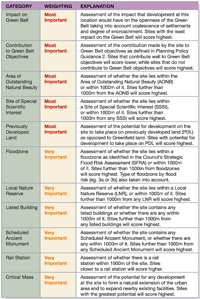
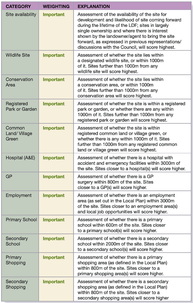
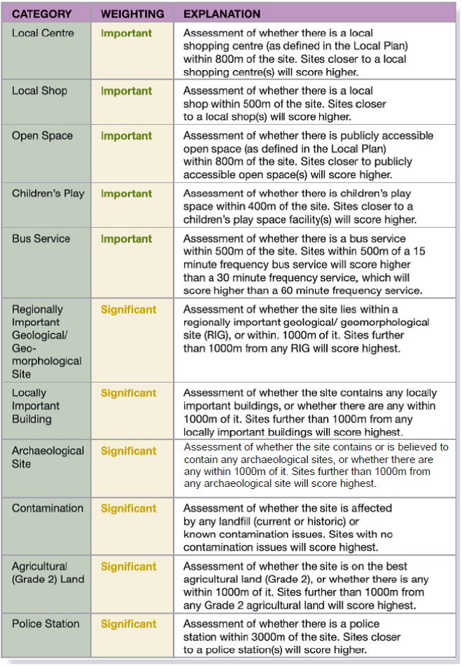
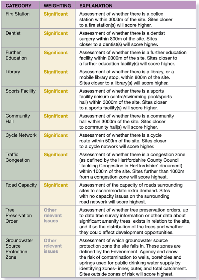
The Council has prepared criteria for the selection of housing sites. These have been developed through earlier public consultation on the Core Strategy and link in closely with the sustainability appraisal process. The approach is set out below:
For every site/area being considered a score of 1-10 will be allocated where 1 reflects where a site/area scores poorly in relation to the Criteria and 10 where it reflects very highly.
Each site/area will be assessed and scored in turn against each of the Criteria in Table 2 below and all of the scores derived for each Criterion will be added up to give an overall score for each site/area. The general approach is that those sites/areas with the highest overall scores will be considered as those with the most potential for future housing development. Those with the lowest scores will be eliminated and not considered further.
The scoring will be carried out as objectively as possible taking into account the location of the site/area in relation to the Criterion/Constraint and potential impact. GIS mapping systems will be used to help with the process to measure distances in this regard. In some cases, for a site/area to score highly it is better to be further away from a Criterion (e.g. an environmental designation such as a Site of Special Scientific Interest) but in others it is better to be located closer to services (e.g. a rail station or health facility). The distances specified will vary according to the Criteria and what is considered 'reasonable' distances in relation to each. They have been derived from standards used in national, regional and local planning policy and/or Sustainability Appraisals.
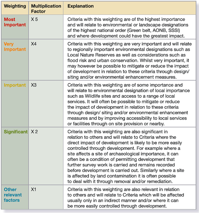
Once scores for each Criterion have been ascertained (this will range from between 1 and 10), they will be multiplied by a factor of between 1 and 5 depending on how important that Criterion is in relation to permitting development in an area. All the Criteria identified are important but it is necessary to distinguish between degrees of importance in this exercise. The five different categories of Weighting are set out in Table 1 below.
It should be noted that whilst the criteria and score of how well a site performs in relation to the range of planning and sustainability criteria will inform the Council's decision on the site, in coming to a final decision the Council will consider each site on its merits and take into account site specific circumstances. It may not be the case that higher scoring sites will automatically be taken forward and that lower scoring sites will not be taken forward.
Table 1: Weighting Applicable to Criteria
The Infrastructure Delivery Plan (IDP)17
seeks to establish what additional infrastructure is required to support
the planned increase in new homes and jobs, and the projected population
growth within the District up to 2026. It includes a review of existing
provision for social infrastructure, (such as health and education facilities),
physical infrastructure, (such as transport and utilities) and green
infrastructure, (such as parks and open spaces). The Plan provides an
analysis of the nature of future provision and, where known, where it
will be provided, when it will be provided, how it will be funded and
who will be responsible for the delivery.
The IDP is accompanied by this Infrastructure Delivery Schedule (IDS)
which sets out those schemes that are currently proposed to take place
during the Core Strategy plan period to 2026.
The list of projects included within the Infrastructure Delivery Plan and Schedule is not intended to be exhaustive, as the process of implementation will constantly be responding to local circumstances and utilising new avenues and drivers to prioritise spend over the life of the Core Strategy. It is intended that the IDP will be updated annually alongside the Annual Monitoring Report.
|
Infrastructure Project |
Reason for Project |
Indicative Delivery Phasing |
Estimated Cost |
Funding Arrangements |
Lead Delivery Agency |
Contingency Planning Required?/Risks |
Health Provision |
|||||||
GP Facilities |
Increase in equivalent to 1.5 GP provision in Abbots Langley Area |
To provide adequate GPs for Abbots Langley |
2015/2016 |
Not identified |
Strategic Capital Funding streams and LIFT |
West Herts PCT |
|
Increase in GP provision in Rickmansworth Area |
To provide adequate GPs for Rickmansworth |
2015/2016 |
Not identified |
Strategic Capital Funding streams and LIFT |
West Herts PCT |
|
|
Investment in existing GP premises or provision of new premises in Croxley Green Area |
To provide adequate floor space to accommodate additional registrations |
2015/2016 |
Not identified |
Developer contributions |
West Herts PCT |
|
|
Satellite Clinic |
Enlargement and redevelopment of Maple Cross Club |
To enable the following outreach services to be provided: Community/Heart Nurses, Health Promotion (smoking cessation) Baby& Diabetes clinics, Health Checks for over 60s |
2010/2011 to 2012/2013 |
£338,000 |
Maple Cross Club |
West Herts PCT |
West Herts PCT yet to confirm provision of services |
Branch Surgery |
Refurbishment of a room at Mill End Community Centre |
To enable health promotion schemes to take place |
2010/2011 to 2012/2013 |
£7,057 |
LSP Capital & Revenue |
West Herts PCT |
West Herts PCT yet to confirm provision of services |
Health Provision Continued |
|||||||
Step-Up Project |
Renovation of suitable building in South Oxhey |
Provision of counselling, advice and learning services for people with mental health issues. |
2010/2011 to 2012/2013 |
£330,000 |
LSP Capital & Revenue |
ASCEND, Herts Mind Network, Turning Point |
|
Education |
|||||||
Primary education provision |
Expansion of Tanners Wood Primary School, Abbots Langley |
To accommodate future demand by increasing school by 0.5 form entry |
2012/2013 |
£1m |
HCC Primary Capital Programme |
Hertfordshire County Council |
|
Feasibility study of expanding an existing primary school in the Rickmansworth Area |
To accommodate future demand |
2012/2013 |
Not identified |
HCC Primary Capital Programme |
Hertfordshire County Council |
|
|
Feasibility study of provision of a new Primary school in the Rickmansworth Area |
To accommodate future demand |
2012/2013 |
Not identified |
HCC Primary Capital Programme |
Hertfordshire County Council |
|
|
Feasibility study of provision of a new Primary school in the Abbots Langley, Leavesden and Bedmond area |
To accommodate future demand |
2012/2013 |
Not identified |
HCC Primary Capital Programme |
Hertfordshire County Council |
|
|
Feasibility study of expanding primary school provision in South Oxhey area |
To accommodate future demand |
2014/15 |
Not identified |
HCC Primary Capital Programme |
Hertfordshire County Council |
|
|
Feasibility study of expanding primary school provision in Croxley Green area |
To accommodate future demand |
2015/16 |
Not identified |
HCC Primary Capital Programme |
Hertfordshire County Council |
|
|
Feasibility study of expanding primary school provision in Carpenders Park area |
To accommodate future demand |
Not identified |
Not identified |
HCC Primary Capital Programme |
Hertfordshire County Council |
|
|
Primary education provision continued |
Feasibility study of expanding primary school provision in Kings Langley area |
To accommodate future demand |
Not identified |
Not identified |
HCC Primary Capital Programme |
Hertfordshire County Council |
|
Feasibility study of expanding primary school provision in Bricket Wood area |
To accommodate future demand |
Not identified |
Not identified |
HCC Primary Capital Programme |
Hertfordshire County Council |
|
|
Secondary education provision |
New Secondary School provision, the expansion of existing schools, or a combination of both in the Rickmansworth Area |
To meet the demand for secondary school places |
2014/2015 |
Not Identified |
HCC Primary Capital Programme |
Hertfordshire County Council |
|
Emergency Services |
|||||||
Police |
Additional Neighbourhood Police in Abbots Langley Area |
To provide additional Neighbourhood Policing in area |
2015/2016 |
Not identified |
Developer contributions |
Hertfordshire Constabulary/Hertfordshire Police Authority |
|
Enlargement of existing facility to accommodate larger team of Neighbourhood Police in Abbots Langley Area |
To provide accommodation for additional Neighbourhood Police |
2015/2016 |
Not identified |
Developer contributions |
Hertfordshire Constabulary/Hertfordshire Police Authority |
|
|
Cultural Services |
|||||||
Library Facilities |
Refurbishment of, and enhancement of existing facilities particularly ICT in libraries across the District |
To improve facilities |
2010/2026 |
Not identified |
Developer contributions |
Hertfordshire County Council |
|
Cemeteries |
New cemetery provision |
To accommodate future demand for traditional burials |
2014/2015 |
Not identified |
Capital |
TRDC |
|
Waste |
|||||||
Composting Facility |
In Vessel Composting facility with capacity for around 50,000 tonnes in the Hemel Hempstead/Watford corridor |
To accommodate future needs |
2014/15 |
Not identified |
Private Finance Initiative |
Hertfordshire County Council |
|
Strategic Transport |
|||||||
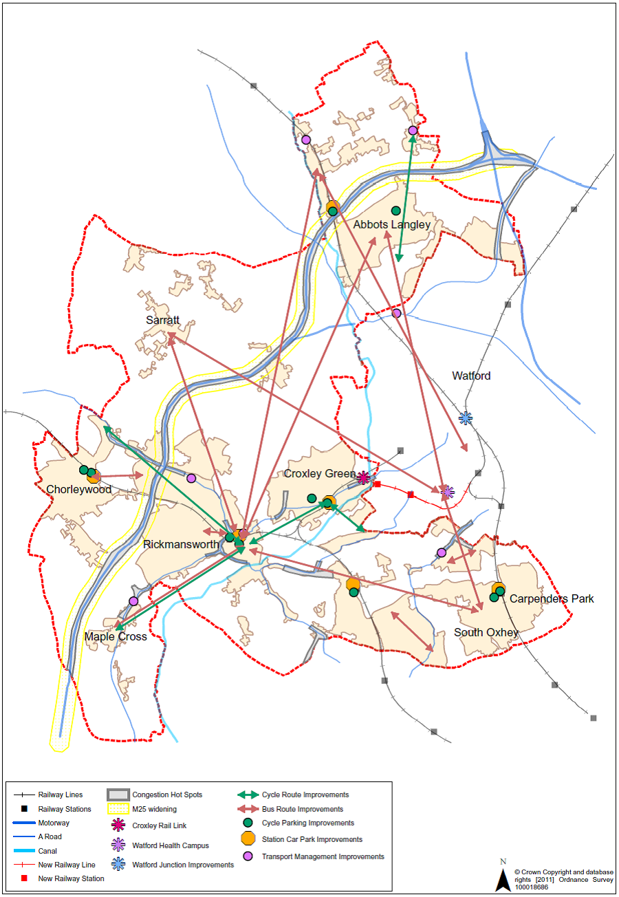
Croxley Rail Link |
Metropolitan Line link to Watford Junction |
Improved access to public transport, to facilities
in Watford, |
2013 – 2020 |
£136.4m |
Regional Funding Allocation |
Transport for London |
|
M25 Widening J16-23 |
Widening of M25. Junctions 17 to 20 |
To accommodate future travel demands
|
2009 – 2013 |
£76.2m |
Private Finance Initiative Contract |
Highways Agency |
|
Local Transport |
|||||||
Traffic Management and Highway Improvements |
College Road, Abbots Langley Pedestrian Crossing Scheme |
To improve safety for people crossing the road |
2010/2011 |
£75,000 |
£65,000 HCC Capital |
Hertfordshire County Council |
|
Traffic calming and drainage measures in Shirley Road, Abbots Langley |
To improve road safety |
2010/2011 |
£74,000 |
Capital |
TRDC |
|
|
Local Transport Continued |
|||||||
Better Buses |
Continue financial support for “318 Flyer” Abbots Langley to Watford town centre |
To allow the retention and enhancement of uneconomic bus routes that serve rural communities and provide transport to facilities and services |
2010/2011 |
Unspecified |
£136,000 contribution from
TRDC to be shared between all schemes |
Herts PTU |
|
Continue financial support for Arriva 8 (Mount Vernon to Woodside/Abbots Langley). |
Herts Passenger Transport Unit |
|
|||||
Continue financial support for W50 Watford – South Oxhey/Carpenders Park station |
|||||||
Continue financial support for R8 Chipperfield to Abbots Langley and Watford. |
|||||||
Continue financial support for R16 (Watford –South Oxhey circular). |
|||||||
Continue financial support for R19 Abbots Langley to Kings Langley station |
|||||||
Continue financial support for R21 Uxbridge to Mount Vernon Hospital |
|||||||
Cycling Network Improve |
Extension of the cycle route between Rickmansworth and Chorleywood
|
To provide an integrated network of safe cycling routes around the District |
2011/2012 |
Unidentified |
Capital |
TRDC |
|
Completion of cycle route between Maple Cross and Rickmansworth Town Centre |
To provide an integrated network of safe cycling routes around the District |
2010/2011 |
£50,000 |
Capital |
TRDC |
|
|
Cycle route between Croxley Green and Rickmansworth Town Centre |
To provide an integrated network of safe cycling routes around the District |
2012/2013 |
£50,000 |
Capital |
TRDC |
|
|
New cycle route from Bedmond to South Way via Abbots Langley |
To provide an integrated network of safe cycling routes around the District |
2011/2012 |
£50,000 |
Capital |
TRDC |
|
|
A new cycle route from Croxley Green Station to Ebury Way via Byewaters Estate |
To provide an integrated network of safe cycling routes around the District |
2013/2014 |
Unidentified |
Capital |
TRDC |
|
|
Green Infrastructure |
|||||||
Provision for Children and Young People |
Refurbishment of Langleybury Play Area (Langleybury) |
Upgrading of LAP provision |
2011/2012 |
£35,000 |
Developer Contributions |
TRDC |
|
Refurbishment of South Way Play Area (Abbots Langley) |
Upgrading of LAP provision |
2011/2012 |
£35,000 |
Developer Contributions |
TRDC |
|
|
New play area in Croxley Green |
New LEAP |
2013/2014 |
£35,000 |
Developer Contributions |
TRDC |
|
|
Refurbishment of Oulton Way Play Area (Carpenders Park) |
Improvement of provision |
2010/2011 |
£105,300 |
Capital |
TRDC |
|
|
Refurbishment of Hayling Road Play Area (South Oxhey) |
Improvement of provision |
2010/2011 |
£192,300 |
Capital |
TRDC |
|
|
Refurbishment of Ashburnham Play Area (South Oxhey) |
Improvement of provision |
2010/2011 |
£97,000 |
Capital |
TRDC |
|
|
New Play Area in Ashridge Ward (South Oxhey) |
New LEAP |
2012/2013 |
£95,000 |
Capital |
TRDC |
Suitable site to be found |
|
New Play Area in Chorleywood |
New LEAP |
2011/2012 |
£95,000 |
Capital |
TRDC |
Suitable site to be found |
|
Refurbishment of Baldwins Lane Play Area (Croxley Green) |
Improvement of provision |
2011/2012 |
£95,000 |
Capital |
TRDC |
|
|
Refurbishment of Scotsbridge Play Area (Rickmansworth) |
Improvement of provision |
2011/2012 |
£95,000 |
Capital |
TRDC |
|
|
Regeneration of South Oxhey Youth Facility |
Provision of BMX track or Street Gym |
2010/2011 |
£37,440 |
Capital |
TRDC |
Final provision dependent on consultation |
|
New Outdoor Gym at West Hyde Youth Centre (West Hyde) |
Provision of new Outdoor Gym facility |
2010/2011 |
£27,100 |
Capital |
TRDC |
|
|
Refurbishment of Baldwins Lane Skate Park (Croxley Green) |
Resurfacing of Skate Park |
2010/2011 |
£100,000 |
Capital |
TRDC |
Feasibility Study to be undertaken to ascertain life span of surface area. |
|
Policy |
Delivering Strategic Objectives |
Indicator |
Target |
Reference/ Comments |
Partners |
|
PSP |
Place Shaping Policies |
S1 |
Dwelling completions by settlement |
15% in the principal town, 60% in the key centres,
24% in the secondary centres, |
Local Indicator |
Private sector/ housing associations/ District Council |
Employment growth by settlement |
No specific target- number will be monitored |
Local Indicator |
Private sector/ District Council |
|||
CP1 |
Sustainable Development |
S2 |
New and converted dwellings on previously developed land |
At least 60% on previously developed land |
Core Indicator SHLAA/UCS/ National target |
Private sector/ housing associations |
Total amount of employment floorspace on previously developed land |
At least 60% on previously developed land |
Core Indicator |
Private sector/ businesses |
|||
Per capita carbon emissions |
Reducing trend |
National Indicator |
Private sector/ District Council |
|||
Household water consumption |
Reducing trend |
Local Indicator |
Private sector/ local residents/ District Council |
|||
Number of conservation area appraisals prepared |
Increasing trend |
Local Indicator |
District Council |
|||
Heritage assets at risk |
Reducing trend |
Local Indicator |
Private Sector /District Council/ English Heritage |
|||
CP2 |
Housing Supply |
S1 |
Housing trajectory |
Complete 4,500 dwellings 2001-2026 at an average of 180 pa |
Core Indicator |
Private sector/ housing associations/ District Council |
CP2 |
Housing Supply |
S1 |
Housing completions within the existing urban area |
75% of total supply 2001-2026 to be within the urban area |
Local Indicator |
Private sector/ housing associations/ District Council |
CP3 |
Housing Mix and Density |
S4 |
Density of housing completions |
No specific target- density will be monitored |
Local Indicator National target |
Private sector/ housing associations/ District Council |
Size of completed dwellings |
30% 1 bed units |
Local Indicator SHMA |
Private sector/ housing associations/ District Council |
|||
CP4 |
Affordable Housing |
S4 |
Gross affordable housing completions |
35% of all new housing to be affordable |
Local Indicator SHMA, |
Private sector/ housing associations/ District Council |
Percentage of new residential development contributing to affordable housing |
100% |
Local Indicator |
Private sector/ housing associations/ District Council |
|||
Tenure mix of affordable housing completions |
70% social rented, 30% intermediate |
Local Indicator SHMA |
Private sector/ housing associations/ District Council |
|||
CP5 |
Gypsy and Traveller Provision |
S4 |
Net additional pitches for Gypsies and Travellers |
No specific target- number will be monitored |
Core Indicator |
District Council, Private sector, |
CP6 |
Employment and Economic Development |
S4 |
Total amount of additional employment floorspace by type |
No specific target- number will be monitored |
Core Indicator |
Private sector/ businesses |
CP6 |
Employment and Economic Development |
S4 |
Employment land available by type |
No specific target- number will be monitored |
Core Indicator |
Private sector/ businesses |
Economically active people in employment |
Maintain a higher percentage of economically active people in employment than the level for East of England and Great Britain |
Local Indicator |
Private sector/ businesses/ District Council |
|||
% of 15 year old pupils in schools maintained by the local education authority achieving 5 or more GCSEs at grades A to C |
Year on year increase in percentage |
Local Indicator |
LEA |
|||
CP7 |
Town Centres and Shopping |
S6 |
Total floorspace for 'town centre uses' |
2000sqm additional comparison goods
floorspace to be provided by 2021. |
Core Indicator Retail Capacity Study. |
Private sector/ businesses |
CP8 |
Infrastructure and Planning Obligations |
S6 |
Delivery of schemes identified in Infrastructure Delivery Schedule in line with indicative phasing |
No specific target- delivery will be monitored |
Local Indicator |
District Council/ County Council/ private sector/ infrastructure providers |
Financial contributions received/ on site facilities provided for community services and infrastructure through development |
No specific target as depend on site circumstances. |
Need to monitor any problems of service delivery |
District Council/ County Council/ private sector/ infrastructure providers |
|||
CP9 |
Green Infrastructure |
S1 |
Change in areas of biodiversity importance |
No net loss of Sites of Special Scientific Interest, Local Nature Reserves or local wildlife sites |
Core Indicator |
District Council/ HBRC/ HMWT |
Condition of Sites of Special Scientific Interest |
Increasing proportion of sites of good/ improving quality |
Local Indicator |
District Council/ HBRC/ HMWT/ Natural England |
|||
Proportion of local biodiversity sites where positive conservation management is being achieved |
Increasing proportion |
National Indicator |
District Council/ HBRC/ HMWT |
|||
New development in the Chilterns AONB |
No specific target- levels will be monitored |
Local Indicator |
District Council/ Chilterns Conservation Board |
|||
Loss/ increase of public open space, sport and recreation facilities |
No specific target- levels will be monitored |
Local Indicator |
District Council |
|||
CP10 |
Transport |
S3 |
Amount of new residential development within 30 minutes public transport time of a GP, hospital, primary school, secondary school, major retail centre |
At least 90% of new residential development to be within 30 minutes public transport time each of a GP, hospital, primary school, secondary school and major retail centre |
Local Indicator |
Private sector/ housing associations/ District Council/ County Council/ PCT/ transport operators |
Delivery of schemes identified in Infrastructure Delivery Schedule |
No specific target- delivery will be monitored |
Local Indicator |
Private sector/ District Council/ County Council |
|||
Number of people killed or seriously injured in road traffic accidents |
Reduction in numbers |
Local Indicator |
County Council/ District Council/ private sector |
|||
CP10 |
Transport |
S3 |
Journeys made by bus/ train |
No specific target- number will be monitored |
Local Indicator |
County Council/ District Council/ transport operators |
CP11 |
Green Belt |
S1 |
New dwellings in the Green Belt |
No specific target- number will be monitored |
Local Indicator |
District Council |
New employment floorspace in the Green Belt |
No specific target- levels will be monitored |
Local Indicator |
District Council |
|||
CP12 |
Design of Development |
S1 |
Residential development for 10 or more dwellings approved contrary to safety and security advice |
No development |
Local Indicator |
District Council |
Commercial development for 1000sqm or more approved contrary to safety and security advice |
No development |
Local Indicator |
District Council |
|||
Crime/ domestic burglaries per 1000 of the population |
Reduce levels year on year |
Local Indicator |
District Council/ police authority |
|||
Number of appeals allowed following refusal on design grounds |
0 |
Local Indicator |
District Council |
|||
Building for life assessment |
No specific target- number will be monitored |
Core Indicator |
Private sector/ housing associations |
|||
For the purpose of this document the following terms and definitions apply.
Glossary and Abbreviations |
|
Accessibility |
The ability of everybody to go conveniently where they want particularly in relation to services and facilities. |
Affordable Housing |
Affordable housing includes social rented and intermediate housing, provided to specific eligible households whose needs are not met by the market. (Planning Policy Statement 3). It does not include low-cost market housing. |
AMR |
Annual Monitoring Report (AMR) assesses the Council's progress in producing the Local Development Documents and implementing policies. |
AONB |
Areas of Outstanding Natural Beauty (AONBs) are designated under the National Parks and Access to the Countryside Act (1949) and, along with National Parks; they represent the finest examples of countryside in England and Wales. |
ASCEND |
ASCEND is located in the All Saints' Church Centre, South Oxhey. Founded by local people to counteract the problems of unemployment, social deprivation and learning disabilities. |
BAP |
Biodiversity Action Plan (BAP) is a strategy prepared for the area aimed at conserving biological diversity. The Hertfordshire Biodiversity Action Plan: A 50 Year Vision identifies key biodiversity areas in Three Rivers. |
BME |
Black and Minority Ethnic Groups. |
Brownfield Land |
Brownfield land (or Previously Developed Land) – land that is, or has been occupied by a permanent structure and associated fixed surface infrastructure. Agricultural and forestry buildings are excluded. |
Capital |
Capital refers to the budget that funds acquisition of a fixed asset. |
CIL |
Community Infrastructure Levy (CIL) – A levy on new developments to support infrastructure delivery. Introduced by the Planning Reform Bill published in November 2007. |
Class A1 |
Retail use classification as defined under the Use Classes (Amendment) Order 2005. Class A1 includes shops, retail warehouses, hairdressers, undertakers, travel and ticket agencies, post offices, dry cleaners, internet cafes etc., pet shops, cat-meat shops, tripe shops, sandwich bars, show rooms, domestic hire shops and funeral directors. |
Combined Heat and Power |
Combined Heat and Power (CHP) is the simultaneous generation of useable heat and power (usually electricity) in a single process. It is a form of decentralised energy technology and typically installed on-site, supplying customers with heat and power directly at the point of use. |
Community, Leisure and Cultural Facilties |
These include, but are not limited to, village halls, community centres, sports halls, theatres, public halls, doctors and dental surgeries, faith facilities, post offices, public houses, schools and local shops. |
Conservation Area |
An area designated under the Planning (Listed Buildings and Conservation Areas) Act 1990 as being of special architectural or historic interest of which it is desirable to preserve and enhance. |
Core Strategy |
The Local Development Framework document which sets out the long-term spatial vision for the local planning authority area and the spatial objectives and strategic policies to deliver that vision. The Core Strategy will have the status of a Development Plan Document. |
CURS |
Centre for Urban and Regional Studies. |
DCSF |
Department for Children, Schools & Families (DCSF). |
DES |
Development Economics Study – A study that assesses the economic viability of land for housing within the District taking account of risks to delivery and likely levels of finance available for affordable housing. |
Developer Contributions |
Contribution in the form of money, land or other means collected from developers to pay towards the cost of infrastructure. |
Development Plan |
The statutory Development Plan currently comprises the Regional Spatial Strategy, Waste and Minerals Framework and the Development Plan Documents (DPD) contained in the Local Development Framework (LDF). |
District |
Three Rivers District. |
DPD |
Development Plan Document (DPD) is a Local Development Document which forms part of the statutory development plan, including the Core Strategy, Site Allocations and Proposals Map. |
Dph |
Dwellings per hectare. |
East of England Plan |
East of England Plan (also known as the Regional Spatial Strategy (RSS)) – set out the broad spatial strategy for the region prepared by the East of England Regional Assembly. |
EERA |
East of England Regional Assembly (EERA) – was the Regional planning and housing body responsible for the production of the Regional Spatial Strategy. It consisted of a partnership of elected representatives from the 54 local authorities in the East of England and appointed representatives from social, economic and environmental interests. The Regional Assembly was abolished on 31 March 2010. |
Employment Land |
Land allocated for industrial and business use. |
Evidence Base |
A collective term for technical studies and background research that provides information on key aspects of social, economic and environmental characteristics of the District. This enables the preparation of a sound Local Development Framework meeting the objectives of sustainable development. |
Green Belt |
Also known as the Metropolitan Green Belt – an area of land which has been specifically designated for long-term protection. It is a nationally important designation and exists to prevent urban sprawl by keeping land open and free from development. |
Greenfield |
Land (or a defined site) which has never been built on before or where remains of any structure or activity have blended into the landscape over time (opposite of brownfield land). |
HCC |
Hertfordshire County Council. |
Hectare |
A unit of land area equivalent to 10,000 square metres or 0.01 of a square kilometre. One Hectare is approximately equal to 2.5 acres. |
Heritage Asset |
A building, monument, site, place, area or landscape positively identified as having a degree of significance meriting consideration in planning decisions. Heritage assets are the valued components of the historic environment. They include designated heritage assets (as defined in PPS5) and assets identified by the local planning authority during the process of decision-making or through the plan-making process (including local listing). |
Herts Mind Network |
Herts Mind Network is a mental health organisation providing a diverse range of recovery orientated services in Hertfordshire. |
Infrastructure |
Collective term for physical structures, facilities and services needed by the community, for example, buildings, roads, power supplies, affordable housing, health, sports, leisure and educational facilities, village halls, doctor's surgeries, churches and open space. |
KCDC |
Key Centre for Development and Change – an area identified by the Regional Spatial Strategy – for regional focus for housing, employment, retail, leisure, tourism, cultural and educational development. |
Key Diagram |
A diagram which illustrates the main strategic principles of the spatial strategy of the Local Development Framework. It is not site-specific, unlike the proposals map. |
Key Workers |
Essential public sector workers such as nurses, teachers and social workers. |
LAP |
Local Area for Play (LAP) a small area of unsupervised open space specifically designed for younger children mainly between the ages of 4-6 years. |
Local Area Agreements |
Local Area Agreements (LAAs) set out the priorities for a local area between central government and a local area (the local authority and Local Strategic Partnership) and other key partners. |
LCBSR |
London Commuter Belt Sub-Region – a sub-region of the East of England Region which consists of Hertfordshire and four Essex Districts (Brentwood, Chelmsford, Epping Forrest and Harlow). |
LDF |
Local Development Framework – the portfolio or folder of Local Development Documents, which set out the planning policy framework for the District. |
LEAP |
Local Equipped Area for Play (LEAP) – is a piece of open space that is designated and equipped for children of early school age. |
LIFT |
Local Improvement Finance Trust (LIFT) is an NHS funding vehicle for improving and developing frontline primary and community care facilities, allowing PCTs to invest in new premises. |
Listed Building |
A building included on a list of buildings of architectural or historical interest compiled by the Secretary of State, under the Planning (Listed Buildings and Conservation Areas) Act 1990. |
Local Development Document |
Local Development Document – comprising two main types: Development Plan Documents and Supplementary Planning Documents, which together from the Local Development Framework. |
Local Nature Reserve |
Local Nature Reserve – a habitat of local or regional significance that makes a useful contribution both to nature conservation and to the opportunities for the community to see, learn about and enjoy wildlife. |
Local Plan |
The plan produced under the former planning system by District Councils. The Three Rivers Local Plan will be replaced by the Local Development Framework. |
Logistics/ Big B8 Sheds |
Units typically in excess of 9,000 sq m (100,000 sq ft) on sites with plentiful parking and yard space; often featuring 20 or more dock levellers; cross docking facilities; over 12m eaves height; 50k/N floor loadings and about 10% office content. Often occupied by food, clothing and white goods retailers. |
London Arc |
The London Arc comprises the area in the East of England closest to and most strongly influenced by London. It includes the districts of Broxbourne, Dacorum, Hertsmere, St Albans, Three Rivers, Watford and Welwyn Hatfield in Hertfordshire and Brentwood and Epping Forest in Essex. |
LSP |
Local Strategic Partnership (LSP). The Three Rivers Local Strategic Partnership is an umbrella partnership that brings together public and private organisations and community groups, allowing different initiatives and services to support one another so that they can work more effectively together. One of its main tasks is to prepare and implement the Sustainable Community Strategy. |
Major Development |
In terms of residential development – 10 dwellings or more or 0.5 hectares. In terms of other development – floorspace of 1,000 square metres or more. (As defined by Communities and Local Government). |
Minor Development |
In terms of residential development – less than 10 dwellings or less than 0.5 hectares. In terms of other development – floorspace less than 1,000 square metres. (As defined by Communities and Local Government). |
On-site renewable technology |
Collective term for domestic scale renewable energy technologies such as solar thermal, solar photovoltaics and domestic wind turbines provided on the site of development. |
OSS |
Open Space Sport and Recreation Study (OSS). A strategy covering open space, playing pitches and sport and recreational facilities to guide future provision and management of existing resources in the District as required by PPG17. |
PCT |
Primary Care Trust (PCTs) – cover all parts of England and take control of local health care. Hertfordshire and West Hertfordshire Primary Care Trust cover Three Rivers. |
PDL |
Previously Developed Land (or Brownfield land) – land that is, or has been occupied by a permanent structure and associated fixed surface infrastructure. Agricultural and forestry buildings are excluded. |
Performance Reward Grant |
A performance related grant awarded by the CLG to Local Strategic Partnerships on their achievement of their LAAs. |
PPG |
Planning Policy Guidance (PPG) – Guidance produced by the Government setting out national planning policy (being replaced by Planning Policy Statements). |
PPS |
Planning Policy Statement (PPS) – Guidance produced by the Government setting out national planning policy (gradually replacing Planning Policy Guidance). |
Private Finance Initiative Contract |
Private Finance Initiative Contract (PFI) relates to the contract between the Highways Authority and private companies who contribute to the cost of and carry out works involved in the widening of the M25. |
Proposals Map |
This map illustrates the policies and proposals in the Development Plan Documents (DPDs) on an Ordnance Survey base. |
Retail Capacity Study |
Retail Capacity Study is an assessment of retail to identify need and gaps in provision and to inform the allocation of sites to meet such need as required by Planning Policy Statement 6. |
Revenue |
Revenue refers to the budget that funds the on going costs of a fixed asset or service. |
RSS |
Regional Spatial Strategy (RSS) (also known as the East of England Plan) – set out the broad spatial strategy for the region prepared by East of England Regional Assembly. |
SA |
Sustainability Appraisal (SA) – Identifies and evaluates the effects of the strategy or plan on social, environmental and economic conditions. |
SCI |
Statement of Community Involvement (SCI) – document setting out how and when stakeholders and other interested parties will be consulted and involved in the preparation of the Local Development Framework (and in the consideration of individual planning applications). |
SCS |
Sustainable Community Strategy – the Council's strategy prepared by the Local Strategic Partnership which takes a partnership approach to improving services, thereby improving quality of life. |
SEA |
Strategic Environmental Assessment (SEA) – an assessment of the environmental effects of a plan or programme required by EU Directive 2001/42/EC. The assessment examines the potential impacts of policies and proposals on the environment and includes proposals for the mitigation of these impacts. |
Secondary Sheds |
Typically provide space for smaller businesses, catering for local markets, and undertaking identifiably industrial activities. Businesses may be involved in cleaning services, distribution, electronics, engineering, flooring, food and drink, import/export, motor trades, printing, sign making and tool making and many other diverse activities. |
SHLAA |
Strategic Housing Land Availability Assessment (SHLAA) – an assessment of land availability for housing, over a fifteen year period required by Planning Policy Statement 3: Housing. (An update on the Urban Capacity Study (UCS) carried out under the requirements of Planning Policy Guidance 3). |
SHMA |
Strategic Housing Market Assessment (SHMA) – an assessment of housing need and demand which can inform the development of Local Development Documents in planning for housing policies, as set out in Planning Policy Statement 3: Housing. |
Smart Sheds |
Commonly high-quality buildings with
hybrid space, allowing flexible production, warehouse and office,
high ceilings (around seven metres), surface-level loading doors,
floor loadings of 30-40 kN per sq m and generous service yards
and parking; all provided within a good quality, managed development
providing say 5-20 units in total. Many building in this sector
range between 1,000 sq m (10,000 sq ft) and 5,000 sq m (50,000
sq ft. |
SPD |
Supplementary Planning Document (SPD) – Elaborates on policies or proposals in Development Plan Documents and gives additional guidance. Successor to Supplementary Planning Guidance. |
Spatial Planning |
System to integrate land use planning policies with the policies of other plans, programmes and strategies which also influence the nature of places and how they function. Also about an integrated and partnership approach towards delivery of development. |
Strategic Flood Risk Assessment |
Strategic Flood Risk Assessment (SFRA) – a study which assesses and maps all forms of flood risk from groundwater, surface water, sewer and river sources, taking into account future climate change predictions. |
Street Gym |
Street Gym is a set of equipment that mirrors an indoor gym with cross trainers, bikes, chest presses etc and is usually located in open spaces. |
Sustainable Development |
In broad terms this means development that meets the needs of the present without compromising the ability of future generations to meet their own needs. The Government has set out the following five guiding principles, in its strategy for sustainable development, “Securing the Future” to be achieved simultaneously: Living within environmental limits: Ensuring a strong healthy and just society: Achieving a sustainable economy: Promoting good governance: and using sound science responsibly. |
TRDC |
Three Rivers District Council (TRDC). |
Turning Point |
Turning Point is a social care organisation providing services for people with complex needs, including those affected by drug and alcohol misuse, mental health problems and learning disabilities. |
UCS |
Urban Capacity Study (UCS) – an assessment of land to identify and allocate land for development required under Planning Policy Guidance 3. Updated by the Strategic Housing Land Availability Assessment. |
Windfall |
Windfall refers to a site not specifically allocated for development in a development plan, but which unexpectedly becomes available for development during the lifetime of a plan. Most “windfalls” are referred to in a housing context. They tend to be very small sites. |
17Three Rivers Infrastructure Delivery Plan (2010) http://www.threerivers.gov.uk