< Previous | Next >
5.2 Economy and Employment
National Planning Policy Background
5.2.1 A core principle of the NPPF52 is to proactively drive and support sustainable economic development to deliver the homes, business and industrial units, infrastructure and thriving local places that the country needs and respond positively to wider opportunities for growth.
5.2.2 The NPPF (para 21) states that Local Plans should:
- set out a clear economic vision and strategy which positively and proactively encourages sustainable economic growth
- Set criteria, or identify strategic sites, for local and inward investment to match the strategy and to meet anticipated needs over the plan period;
- Support existing business sectors, taking into account of whether they are expanding or contracting and, where possible, identify and plan for new or emerging sectors likely to locate in the area. Policies should be flexible enough to accommodate needs not anticipated in the plan and to allow a rapid response to changes in economic circumstances;
- Plan positively for the location, promotion and expansion of clusters or networks of knowledge driven, creative or high technology industries;
- Identify priority areas for economic regeneration, infrastructure provision and environmental enhancement; and
- Facilitate flexible working practices such as the integration of residential and commercial uses within the same unit.
5.2.3 The NPPF (para 157) states that Local Plans should allocate sites to promote development and the flexible use of land, bringing forward new land where necessary, and provide detail on form, scale, access and quantum of development where appropriate.
5.2.4 However, the NPPF (para 22) also states that planning policies should avoid the long term protection of sites allocated for employment use where there is no reasonable prospect of a site being used for that purpose.
The Requirement
5.2.5 Section 4 and Policy SP3 set out the target for employment land provision over the Plan period 2012-2032 of at least 66 Ha. Taking account of existing completions and commitments to 31 March 2017, it identifies a need to allocate at least 27.87 hectares of land.
Identifying the supply
Housing and Economic Land Availability Assessment ‘SHLAA’
5.2.6 The NPPF (paragraph 159) requires local planning authorities to prepare a Strategic Housing Land Availability Assessment (SHLAA) to establish realistic assumptions about the availability, suitability and likely economic viability of land to meet the identified need for housing over the plan period. Paragraph 161 encourages authorities to undertake assessments of land available for economic development at the same time as, or combined with the housing SHLAA.
5.2.7 The Burnley Strategic Housing and Economic Land Availability Assessment Update 2017 (SHLAA) is a combined assessment which assesses the amount of land available within the borough that is potentially available to meet the identified need and demand for new employment and housing development.
5.2.8 It indicates that over the plan period there is sufficient ‘developable’ land to provide approximately 40.87 hectares of employment development on a range of sites outwith the current Green Belt.53
5.2.9 Informed by the SHLAA, the employment land requirement is provided for in line with the Spatial Strategy identified in Policy SP4 through the allocation of existing vacant or underused previously-developed employment sites within the existing Tier 1 and 2 settlements (Burnley and Padiham) and through the allocation of new sites beyond but closely related to their current urban boundaries and the factors listed at paragraph 4.3.5.
Site Allocations
5.2.10 The sites identified in Policy EMP1 will provide sufficient land to meet the identified residual requirement identified in Policy SP3.
5.2.11 The acceptable uses have been identified on the basis of the development strategy set out in Policy SP4 and the individual characteristics of the sites and their locations, including the following:
- The NPPF states that main town centre uses, such as offices (B1 (a)) should be located in town centres, then in edge of centre locations and only if suitable sites are not available, should out of centre sites be considered. In such instances, a sequential test should be applied.
- The likely traffic impacts of the specific uses proposed e.g. sites for B8 uses would need very good road access to accommodate larger vehicles.
- B8 uses are likely to require large buildings which can be more difficult to assimilate into the landscape/townscape.
5.2.12 The 2016 Burnley Employment Land Demand Study in calculating its land demand assumed a plot ratio of 40% (i.e. 40% of each site is expected to be occupied by buildings) which reflects the ODPM Employment Land Review Guidance Note (2004). Policy SP3 requires that development makes efficient use of land. Applications will therefore be assessed using this ratio as a starting point, but operated flexibly to ensure an appropriate quality of development is achieved.
5.2.13 Applications for suitable uses on the allocated sites would need to address the specific policy requirements set out in Policy EMP1 and the requirements of all other relevant policies of the Plan.
5.2.14 The Council’s SFRA (Level 1) assessed all the Council’s SHLAA sites against risks from all sources of flooding. A small number of sites including Vision Park and a small section of the Land South of Network 65 which lie partly within Flood Zones 2 and 3 are identified for allocation. These, along with sites including the Thompson Centre Car Park identified as being at significant risk of surface water flooding, have been subject to a Level 2 SFRA. This provides advice as to how flood risk at these sites can be avoided or effectively mitigated over their lifetime through design, layout and sustainable drainage. Where flood risk is identified, a site specific Flood Risk Assessment (FRA) will be required to accompany any planning application. A number of other sites, being over 1 hectare in size, will also require an FRA in accordance with Policy CC4.54
Policy EMP1: Employment Allocations
1) Over the 20 year period from 2012 to 2032, provision will be made to deliver at least 66 hectares (Ha) of employment land across the borough in line with Policy SP3.
2) The sites listed below, as identified on the Policies Map, are allocated for employment use* and are protected for the employment uses specified. (*Site EMP1/8 is allocated for a mixed use development and the policy requirements set out in this policy include both uses.)
3) Development on these sites will be acceptable for the specified use classes and will be required to be delivered in accordance with the specific requirements set out, together with the requirements of other policies set out elsewhere in this Plan.
4) The Council will consider withdrawing permitted development rights to protect the sites for the employment uses proposed. |
| Site Ref & Name |
Greenfield/
Brownfield |
Gross Site Area (Ha) |
Acceptable Uses
(Use Classes) |
| EMP1/1 – Rossendale Road (North) |
Greenfield |
4.65 |
B1 (b & c) & B2 |
EMP1/2 – Burnley Bridge
|
Brownfield |
3.14 |
B1 (b & c), B2 & B8 |
EMP1/3 – Vision Park
EMP1/4 – Stoneyholme Gas Works
|
Greenfield
Brownfield |
5.05
0.50 |
B1 (b & c), B2, D1 and limited B1(a)
B1 (b and c) & B2 |
| EMP1/5 – Land South of Network 65 |
Greenfield |
13.32 |
B1 (b & c), B2 & B8 |
EMP1/6 – Balderstone Lane
EMP1/7 – Westgate
EMP1/8 and TC4/2– Thompson Centre (Mixed Use)
EMP1/9 – Innovation Drive |
Greenfield
Brownfield
Brownfield
Brownfield |
2.12
1.80
0.65
0.97 |
B1 (b & c), B2 & B8
B1, B2 & small scale B8 and Sui-Generis uses which are similar in character and compatible in terms of use with the surrounding area
B1 (a), A2 & A3
B2 & B8 |
EMP1/10 – Widow Hill Road South
|
Greenfield
|
0.63
|
B2 & B8
|
| EMP1/11 (and HS1/28) – George Street Mill (Mixed Use)55 |
Brownfield |
0.00 |
C1, C2, C3 and D1 |
| Total |
|
32.83 |
|
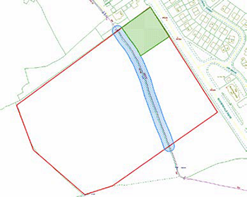
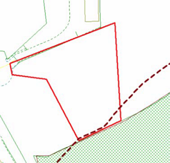
| EMP1/1 – Roseendale Road(North) Site Area: 4.65 hectares |
 © ©
|
| This site is located close to the existing Rossendale Road Industrial Estate and is acceptable for B1 (b & c) and B2 uses. |
Additional and Site Specific Policy Requirements and Design Principles
- The majority of development should be located to the west of the stream, leaving an 8 metre easement around the stream itself (indicated in blue on the above site plan). No built form should be located within the area indicated in green on the above site plan; this should be landscaped as open space forming part of a network of green infrastructure utilising the stream that runs across the eastern section of the site. Facilities to encourage employee usage of the site during breaks should be incorporated into any design.
- Development on this site will be expected to consist of low rise units with a maximum ridge height of 7 metres which takes into account and integrates with the contours of the natural landscape. The development will be expected to incorporate natural materials such as local stone to ensure a quality design which will lessen the development’s impact on the surrounding landscape and streetscape.
- Appropriate landscaping and boundary treatment should include screening to the western boundary along with roadside trees and shrubs adjacent to Rossendale Road. New planting on the site should accord with Policy NE3.
- Vehicular access should be from a single point on the northern part of the site onto Rossendale Road. Appropriate traffic management systems may be required to both ingress and egress the site.
- Pedestrian and cycle routes should be provided on site and contributions may be sought for off-site provision or improved cycle links.
- An ecological survey should accompany any planning application which addresses any impacts on Protected Species and/or Priority Habitats in accordance with Policy NE1.
|
Supporting Information
- Lancashire County Council highway engineers have advised that vehicular access onto the site onto Rossendale Road should be at the northern edge of the site with appropriate sight lines and traffic management infrastructure and have highlighted that the development could adversely impact on the local road network with increased congestion at the Rosegrove and the Manchester Road signal junctions. The Burnley-Pendle Growth Corridor programme has identified fully funded improvements to the Rosegrove junction to be undertaken by Lancashire County Council but further improvement may be required for which contributions may be sought under Policy IC4.
- The Burnley Green Infrastructure Strategy identifies Rossendale Road as an area which would benefit from enhanced GI in terms of improving the aesthetics of the road and its surroundings. New tree planting would assist whilst also providing other beneficial actions including the trapping of air pollutants, the absorption of noise, providing shade from the sun and evaporative cooling opportunities.
- The Burnley Green Infrastructure Strategy identifies the stream running across the east of the site as an area of GI to enhance for supporting wildlife. Any development will need to address its potential ecological impact and/or mitigation measures in accordance with Policy NE1 and ensure network linkages remain on the site.
- The site may house Protected Species and priority habitat (neutral grassland).
- The Grade II Listed Habergham Hall Farmhouse lies around 180m west of the site. The detailed design of any scheme will need to address the potential impact on the setting of the listed building in accordance with Policy HE2.
|
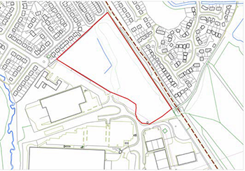
| EMP1/2 – Burnley Bridge Site Area: 3.14 hectares |
 © ©
|
The site forms part of the larger Burnley Bridge Business Park which is located to the west of the borough with direct access onto the M65 at Junction 9.
The Business Park Site has outline planning permission. B1 b and c, B2 and B8 uses would be acceptable. |
Additional and Site Specific Policy Requirements and Design Principles
- The scale and massing of any development on the northern section of the site should be single- storey units with a maximum ridge height of 7 metres in order to limit the impact of development on the surrounding residential properties.
- Vehicular access should be from the south of the site across the bridge over the Leeds & Liverpool Canal.
- A landscaping scheme should be submitted which retains the existing bund on the northern boundary of the site and includes screen planting on the eastern boundary to restrict/reduce the impact of any development on the surrounding residential properties and wider landscape. New planting should accord with Policy NE3.
- A new or updated ecological survey should accompany any planning application which addresses any impacts on Protected Species or other Lancashire Biodiversity Action Plan species and the Lancashire Ecological Networks for Woodland and Grassland in accordance with Policy NE1.
|
Supporting Information
- Outline planning permission was granted in 2010 for B1, B2 and B8 uses on the majority of the Business Park site. (APP/2008/0805).
- A contaminated land survey should be prepared to accompany any planning application in accordance with Policy NE5.
- Pylons and powerlines are located on the site. Developers will need to liaise with National Grid to determine appropriate building heights and siting.
- Lancashire County Council highway engineers have indicated that there should be no access to motor vehicles from the residential area to the north from Cambridge Drive or to Hapton via Pollard Moor.
- The Leeds & Liverpool Canal runs adjacent to the Burnley Bridge southern boundary and is identified as a green infrastructure asset and a corridor for wildlife in the Burnley Green Infrastructure Strategy.
- The northern and eastern boundary of the site is identified as a stepping stone for grassland and woodland in the Lancashire Ecological Network. The Pollard Moor Biological Heritage Site (BHS) is also to the west of Business Park. Lancashire Biodiversity Action Plan species are known to be present on the site. Development will need to address the potential ecological impacts in accordance with Policy NE1.
- Burnley Green Infrastructure Strategy also identifies the whole Burnley Bridge site as an area of potential to create GI in relation to managing water resources and reducing flood risk by increasing water infiltration opportunities. It also identifies an opportunity on the southern boundary of the south site for aesthetic improvements, the trapping of air pollutants, heritage and cultural needs in association with the canal.
|
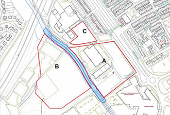
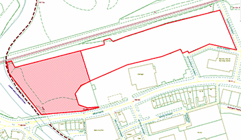
| EMP1/3 – Vision Park Site Area: 5.05 hectares |
 © ©
|
| This site is located close to Burnley Town Centre with convenient access onto the M65 (east- bound) at Junction 11. Site A currently has planning permission for employment use and is suitable for B1 (b and c) and B2 uses. Sites B and C are also suitable for B1 (b and c) and B2 uses and limited B1a uses are also acceptable. Site B is also suitable for D1 uses. |
Additional and Site Specific Policy Requirements and Design Principles
- An 8 metre easement around the River Calder is required (indicated in blue on the above site plan). Any development within this easement may require an environmental permit for flood risk activities. Developers are encouraged to seek early engagement with the Environment Agency regarding design.
- A maximum of 4,000m2 of B1a floorspace will be permitted.
- Vehicular ingress should be from Princess Way or Holme Road via the roundabout at Junction 11, with egress directly onto the roundabout at Junction 11 of the M65. Holme Road may require upgrading to take the additional traffic. A new access bridge will need to be developed across the River Calder to site B.
- New on-site walking and cycling facilities and routes will need to be provided, connecting the new development to the existing route network at Rectory Road. A public right of way crosses across part of the site (dashed line on site plan above). This should be retained/re-routed within the site and improved as part of any future development.
- Replacement provision for the loss of the existing playing pitch at Stoneyholme will need to be identified before any planning permission in respect of site B is granted and will need to be delivered before work begins on site. A potential site for this re-provision is at Prairie Sports Village.
- The established trees and shrubs, in particular those adjacent to the River Calder and along the site boundaries should be retained as part of a wider landscaping scheme to reduce the impact of development on nearby residential properties, the bowling club and the wider landscape and to support wildlife. Potential ecological impacts will need to be considered as the site is known to house Protected Species and a pond (Priority Habitat) An ecological survey will be required to accompany any planning application which addresses Protected Species and Priority Habitats in accordance with Policy NE1.
- Site B is identified within Flood Zone 2. The layout and design of any development should take account of the recommendations of the Council's Strategic Flood Risk Assessment. Any development will need to be accompanied by a Flood Risk Assessment in accordance with Policy CC4 and seek opportunities to reduce the overall level of flood risk in the area through the layout and form of the development and through the provision of an appropriate sustainable drainage scheme.
- Archaeological evaluation is required to assess the survival and significance of any remains from past industrial use. Should there be significant probability of surviving buried remains then field evaluation will be required consistent with Policy HE4; and any further investigation or recording works that may be necessary as a consequence of development.
|
Supporting Information
- B8 is not deemed an appropriate use in this location due to the limitations of Holme Road, the new bridge requirement and the associated vehicles and trips associated with a B8 use. A limited amount of B1(a) development will be permitted on the site as an exception to the town centre first approach of Policy TC2 for such uses, in order to address potential safety concerns in relation to the pedestrian flows from the adjacent college.
- Lancashire County Council highway engineers have advised that the preferred egress for all site parcels would be via the roundabout at junction 11 of the M65 with no egress onto Rectory Road.
- Replacement provision for the loss of the existing playing pitch at Stoneyholme will need to be identified. The current proposal is for a new 3G pitch at the Prairie Sports Village. The delivery of this replacement facility should be carried out in consultation with Sport England.
- The Burnley Green Infrastructure Strategy identifies the River Calder corridor as an area to potentially create GI that would support wildlife. Existing and new vegetation would provide further opportunities for improved shading from the sun and evaporative cooling. The GI Strategy also identifies the site as being within an area of need for food production.
- The site is known to house Protected Species and other Lancashire Biodiversity Action Plan species and includes Priority Habitat. Mitigation measures should accord with Policy NE1.
- The site is bisected by the River Calder, a main river and much of it, particularly site B is within Flood Zone 2.
- A site investigation survey may be required on the site due to the proximity of Clifton Colliery.
|
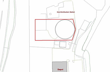
| EMP1/4 – Stoneyholme Gas Works Site Area: 0.05 hectares |
 © ©
|
| This site is located on Oswald Street and would be suitable for B1 (b & c) and B2 uses. |
Additional and Site Specific Policy Requirements and Design Principles
- Potential ecological impacts will need to be considered as the site may house Protected Species.An ecological survey will be required to accompany any planning application identifying and addressing any Protected Species present in accordance with Policy NE1.
- An appropriate hard and soft landscaping scheme should be submitted which provides for adequate screening and appropriate boundary treatment.
- Contributions for off-site highway and junction improvements in accordance with Policy IC4 may be sought to address any adverse impact on existing traffic flows onto Brougham Street.
|
Supporting Information
- The site is within 50m of a Biological Heritage Site (BHS) and adjacent to the Lancashire Ecological Network for grassland and woodland. Development will need to address any impacts on the BHS and ensure links are maintained as part of any development. This could be incorporated into the landscaping of the site.
- As a former industrial site, contamination investigations and the appropriate remediation will be required in accordance with Policy NE5.
|
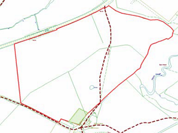
| EMP1/5 –Land South of Network 65 Site Area: 13.32 hectares |
 © ©
|
| This site is located adjacent to the existing Network 65 Business Park at junction 9 of the M65. It would be suitable for B1 (b & c), B2 and B8 uses (excluding outdoor storage). |
Additional and Site Specific Policy Requirements and Design Principles
- This is a prominent site located on a key gateway into Burnley. The development in its density, layout and design of buildings must take into account the topography of the site and the surrounding landscape in accordance with Policy NE3, its landscape setting and the site’s ecological importance to minimise impacts. Any development proposals should be accompanied by a visual impact assessment to determine the appropriate location and design of units on the site. The development is expected to utilise natural materials in both the building and boundary features, such as local stone, particularly along the Accrington Road frontage. The existing dry stone walls should be retained, allowing for any set back at the new road junction.
- No built form should be developed within the green hatched area on the above site plan; this should be landscaped as open space to lessen the development impact on the nearby residential properties.
- Screen planting should be introduced as part of a wider landscaping scheme at the south western, south eastern and northern boundaries of the site to restrict/reduce the impact of any development on the adjacent residential properties and surrounding landscape.
- A small section of the site is identified within Flood Zone 2 and 3. The layout and design of any development should take account of the recommendations of the Council's Strategic Flood Risk Assessment. Any development will need to be accompanied by a Flood Risk Assessment in accordance with Policy CC4 and seek opportunities to reduce the overall level of flood risk in the area through the layout and form of the development and through the provision of an appropriate sustainable drainage scheme.
- Walking and cycling facilities will need to be provided on the site and a new appropriately lit walking and cycling route connecting the site to the existing Network 65 business park should be provided, enabling the new development to be connected to the existing route network on the Leeds & Liverpool Canal and Padiham Greenway. There is a public right of way which crosses the site which will need to be retained/re-routed within the site and improved as part of any development (dashed line on site plan above).
- Contributions for off-site highway and junction improvements in accordance with Policy IC4 may be sought if the development has an adverse impact on existing traffic flows.
- The site is known to house Protected Species, Priority Habitat and forms part of the Lancashire Ecological Network for grassland. An ecological survey (to include a breeding bird survey) will be required to accompany any planning application which identifies and addresses these issues in accordance with Policy NE1.
- The presence of the Medieval Hapton Deer Park within close proximity of the site would suggest that there is potential for unknown archaeology of local to regional significance relating to the Deer Park Pale (boundary). Suitable provision will need to be made for archaeological desk based assessment and field evaluation consistent with Policy HE4 ; and any further investigation or recording works that may be necessary as a consequence of development.
|
Supporting Information
- The Burnley Green Infrastructure (GI) Strategy identifies the site as being within an area of potential to create green travel routes.
- Lancashire County Council highway engineers have indicated that unless the site is developed as an extension to the existing site, the only suitable access is via a new junction on Accrington Road which will require localised widening and traffic management arrangement to ensure safe ingress and access.
- The Burnley Highways Impact Assessment (2017) indicates that without mitigation the southern roundabout at Junction 9 of the M65 will be incapable of supporting additional development beyond the completion of the current Burley Bridge Business Park site.
- The Lancashire Ecological Network identifies part of the site as being a corridor for grassland and the site is known to house Protected Species and other Lancashire Biodiversity Action Plan species. It includes Priority Habitat (grassland and pond).
|
| EMP1/6 – Balderstone Lane Site Area: 2.12 hectares |
 © ©
|
| This site is located on the existing Heasandford Industrial Estate and would be suitable for B1 (b & c), B2 and B8 uses. |
Additional and Site Specific Policy Requirements and Design Principles
- An 8 metre easement around the two streams is required (approximate position indicated in blue on the above site plan).
- New walking and cycling facilities and routes will need to be provided on the site, connecting the new development to the existing route network. There is a public right of way which runs along the western boundary of the site which will need to be retained/re-routed within the site and improved as part of any development (dashed line on site plan above). Contributions will be sought for the provision of a defined on-road cycling route connecting to the existing network in accordance with Policy IC4.
- Screen planting will be required on the northern and eastern boundary of the site as part of a wider landscaping scheme to reduce the impact of any development on the adjacent residential properties and surrounding landscape.
- Potential ecological impacts should be considered as Protected Species have been recorded and the site is identified within a stepping stone within the Lancashire Ecological Networks for woodland and grassland. An ecological survey will be required to accompany any application which addresses the Protected Species and maintains the Ecological Network in accordance with Policy NE1.
|
Supporting Information
- A ground condition survey may be necessary due to the past mine workings within the area.
|
| EMP1/7 –Westgate Site Area: 1.80 hectares |
 © ©
|
| This site is located close to Burnley Town Centre and would be suitable for B1, B2, small scale B8 and Sui-Generis uses which are similar in character and compatible in terms of use with the surrounding area. |
Additional and Site Specific Policy Requirements and Design Principles
- The site is located on a Key Gateway into Burnley Town Centre. Development will be expected to reinforce the site’s ‘Key Gateway’ role and waterfront location; create a positive and appropriate relationship with surrounding buildings and spaces by respecting the form, scale and materials of the surrounding townscape; and be of high design integrity consistent with Policy SP5.
- A building of landmark quality is envisaged to the west of the site as marked red on the plan above. This building and any boundary treatment should use a palette of materials which includes high quality locally distinctive materials in accordance with Policy SP5. High quality suitable and complementary contemporary materials and design may also be acceptable.
- The setting of the heritage assets adjacent the site should be conserved and where possible enhanced consistent with Policy HE2.
- Proposals should contribute to an improved public realm consistent with the Burnley Town Centre Public Realm Strategy SPD.
- Vehicular egress would need to be via Clifton Street or Hattersley Street with the necessary traffic management infrastructure put in place.
- The Leeds & Liverpool Canal runs adjacent to the site; to encourage sustainable travel, a walking and cycling link should connect the site to the canal towpath which is part of the national cycle network (National Route 604).
|
Supporting Information
- The Leeds & Liverpool Canal is a national cycle route. To take advantage of this and to encourage more sustainable travel; a route should be provided linking the development site to the canal towpath.
- The site is located in a prominent position, immediately adjacent the Canalside Conservation Area and the Grade II Listed Belle Vue Terrace and Belle Vue Mill and is considered to make a contribution to their setting.
|
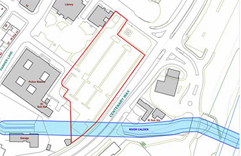
| EMP1/8 and TC4/2 – Thompson Centre Site Area: 0.65 hectares |
 © ©
|
| This site is located within Burnley Town Centre and would be suitable for all B1 (a), A2 and A3 uses. |
Additional and Site Specific Policy Requirements and Design Principles
- The site should be developed for a building(s) of multiple storeys, providing accommodation for B1 (a), A2 and A3 uses. A2 and A3 uses should be limited to the ground floor only.
- The site is prominently located on a Key Gateway into Burnley town centre and will form part of the civic square of Burnley. It is expected that any development will accord with the Burnley Town Centre Public Realm Strategy SPD and be of the highest quality of architecture and design using a palette of materials which respects the character and appearance of the surrounding listed and locally listed buildings and conservation area. The use of more contemporary materials and design features of a complementary nature will also be acceptable. The principal elevation facing the square should extensively use ashlar stone. A design competition approach would be supported on this site.
- The layout of the site should be permeable to pedestrians and enable views of the civic buildings such as the library, court and offices from Centenary Way. Active frontages are encouraged onto Place de Vitry and Centenary Way.
- Vehicular access to the development would need to be directly off Parker Lane or Red Lion Street.
- The established trees along Centenary Way and Red Lion Street should remain where possible.
- Much of the site is at risk from surface water flooding. The layout and design of the development should take account of the recommendations of the Council's Strategic Flood Risk Assessment. Any development will need to be accompanied by a Flood Risk Assessment in accordance with Policy CC4 and seek opportunities to reduce the overall level of flood risk in the area through the layout and form of the development and through the provision of an appropriate sustainable drainage scheme.
- Archaeological evaluation is required to assess the survival and significance of any remains from past industrial use. Should there be significant probability of surviving buried remains then field evaluation will be required consistent with Policy HE4; and any further investigation or recording works that may be necessary as a consequence of development.
|
Supporting Information
- There are a number of listed buildings and locally listed buildings close to the site and the Town Centre Conservation Area is situated to the west of the site. The detailed design of any scheme will need to address the potential impact on the setting of the listed buildings and the Conservation Area in accordance with Policy HE2.
- A land contamination investigation and any relevant remediation will be required in accordance with Policy NE5.
- A culverted section of the River Calder crosses the southern boundary of the site and it is likely an Environmental Permit for flood risk activities would be required. Developer liaison with the Environment Agency is recommended.
- There is a bat roost close to the site. A bat survey will be required in order to address any impacts on bat populations.
|
| EMP1/9 – Innovation Drive Site Area: 0.97 hectares |
 © ©
|
| This site is located on Innovation Drive, adjacent to Heasandford Industrial Estate and would be suitable for B1(b and c) and B2 uses, with limited B1(a) or B8 uses (excluding open storage) |
Additional and Site Specific Policy Requirements and Design Principles
- Development that complies with the conditions contained within the Aerospace Supplier Park Local Development Order (LDO) will be supported.
- The Local Development Order authorises development within Class B (as set out in para. 2.11 and 2.12) of the Town and Country Planning (Use Classes) Order 1987 as amended in so far as it relates to advanced engineering and manufacturing. Advanced engineering and manufacturing typical uses may include:
- Aerospace (30.3, 28.4, 33.16)
- General Aviation Services (52.23)
- High-end automotive including motorsport, electric/alternative energy vehicles, (29.1, 29.3)
- Computing, systems engineering and autonomous systems (62.01, 72.1)
- Advanced flexible materials (13.96, 20.6)
- Manufacture of fabricated metal products, except machinery and equipment (25.4, 25.5 and 25.6)
- Manufacture of computer, electronic and optical products (26.1)
- Renewable energy (27.1, 28.11)
- Development for purposes falling within the above Standard Industrial Classification (SIC) Codes is automatically within the scope of the LDO. However, advanced engineering or manufacturing purposes which fall outside of the above SIC Codes, or for complementary or supporting or ancillary uses, would potentially also be acceptable, and where such purposes are proposed the Local Planning Authority, will make an assessment of each such proposed development to ensure that they are within the permitted uses under the LDO.
- Development outside the scope of the LDO will require the submission of a planning application. No development will be permitted within the boundary of the Biological Heritage Site.
- A minimum of 40% of the site area will need to be developed as floor space (3,900sqm).
|
Supporting Information
- A Local Development Order (LDO) has been adopted for Innovation Drive; any developments, whether progressed under the terms of the LDO or through any a planning application will need to adhere to the requirements as set out in the LDO.
- A section of the eastern site is located within a Biological Heritage Site (BHS) and Protected Species are recorded on site, (including 4 amphibian species). The site is adjacent to deciduous woodland (priority habitat). Condition 11 of the LDO states no development is permitted within the boundary of the Biological Heritage Site and condition 12 of the LDO states all proposals shall be in accordance with the recommendations set out in the Ecology Study.
- The Lancashire Ecological Network identifies part of the eastern site as within a stepping stone habitat for woodland.
|
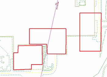
| EMP1/10 - Widow Hill Road South Site Area: 0.63 hectares |
 © ©
|
| This site is located on the existing Heasandford Industrial Estate and would be suitable for B2 and B8 uses. |
Additional and Site Specific Policy Requirements and Design Principles
- Vehicular access should be directly off Widow Hill Road.
- New walking and cycling facilities and routes will need to be provided on the site, connecting the new development to the existing route network. A public right of way is located to the south of the site which will need to be retained/re-routed within the site and improved as part of any development (dashed line on site plan above).
- The existing established vegetative screening to the south and east of the site should be incorporated into a new landscaping scheme, reducing the impact of any development on the adjacent River Don-Brun Valley Biological Heritage Site and residential properties.
- Potential ecological impacts should be considered on the site as it is adjacent to the River Don- Brun Valley Biological Heritage Site (green area on site plan above). Protected species including Great Crested Newt are recorded on site. The site itself is identified as a stepping stone habitat for grassland and woodland in the Lancashire Ecological Network and an ecology survey should be submitted to accompany any planning application which should indicate how the development will address impacts on protected species and priority habitats and maintain habitat connectivity in accordance with Policy NE1.
- Contributions will be sought for the provision of a defined cycling route to the site in accordance with Policy IC4.
|
| Supporting Information - None |
| EMP1/11 and HS1/28–George Street Mill( Mixed Use) Site Area: 0.98 hectares56 |
 © ©
|
| This site would be suitable for B1, C2, C3 and D1 uses. |
Additional and Site Specific Policy Requirements and Design Principles
- Development will be expected to positively address its waterfront location; create a positive and appropriate relationship with surrounding buildings and spaces by respecting the form, scale and materials of the surrounding historic townscape; and be of high design integrity consistent with Policy SP5. Design and layout should positively address the level differences on the site and should contribute to an improved public realm consistent with the Weavers’ Triangle Public Realm Strategy SPD.
- The site includes Charlotte Street Mill, a non-designated heritage asset. The significance of heritage assets, including their settings, within and adjacent to this site should be conserved and, where possible, enhanced consistent with Policy HE2. Particular consideration should be given to the potential impact on the Canalside Conservation Area, the setting of the Grade II Trafalgar Mill and key views to landmark heritage assets that are visible from the site.
- New walking and cycling facilities and routes will need to be provided on the site, connecting the new development to the existing route network along the Leeds & Liverpool Canal.
- Archaeological evaluation is required to assess the survival and significance of any remains from past industrial use. Should there be significant probability of surviving remains then field evaluation will be required consistent with Policy HE4; and any further investigation or recording works that may be necessary as a consequence of development.
|
Supporting Information
- The site lies within the Canalside Conservation area. The design and layout should address the potential impact on the setting and thus significance of the adjacent listed buildings, and on the Conservation Area in accordance with Policy HE2 and the adopted Weavers’ Triangle and Burnley Town Centre Public Realm Strategy SPDs.
- George Street Mill is the site of a previous textile works, therefore, potential ground contamination issues will need to be considered in accordance with Policy NE5.
- Due to the nature of the buildings, a bat survey is recommended.
- The site previously had outline planning permission for a mixed use development of residential and commercial uses (APP/2013/0194) including 3,700sqm of B1 b and c floorspace.
|
Improving and Making Best Use of Existing Employment Land
National Planning Policy Background
5.2.15 The NPPF indicates that local planning authorities should support existing business sectors, taking into account whether they are expanding or contracting, and that they should identify priority areas for economic regeneration, infrastructure provision and environmental enhancement.
5.2.16 The NPPF indicates that where there is no prospect of a site being used for employment use, applications for alternative uses should be treated on their merits having regard to market signals and the relative need for different land uses to support sustainable local communities.
Issues
5.2.17 It is important to ensure that there are sufficient employment sites to meet future needs and to enable existing businesses to grow. Whilst the provision of new sites will make a very important contribution to the supply of employment sites, it is existing provision that will provide most of the supply. It is therefore vital that best use is made of existing employment premises where these still meet or can be upgraded to meet modern business requirements.
5.2.18 Employment sites can come under pressure for alternative and/or higher value development uses e.g. housing or retail use and whilst this may be acceptable or welcomed in some locations e.g. in town centres or residential areas, the cumulative loss of employment sites will have an adverse effect on business and jobs wishing to establish, expand or relocate.
5.2.19 The borough’s employment sites are home to a wide variety of businesses from large scale factories and distribution warehouses to small scale local garages or business start-up units. Whilst these are all important, the wide variety and nature of these sites means that is not practical to seek to protect them all for future employment use. Some older industrial floorspace in the borough is vacant, in poor condition or has poor vehicular access and some existing premises can be incompatible with adjoining uses. However, this is not always the case and small sites and traditional or older buildings of this type can be successfully reused without causing a nuisance and can provide lower cost premises for some businesses.
5.2.20 The borough has a number of larger established industrial and business estates which provide the most flexible supply of land and premises and have good vehicular access to accommodate larger industrial vehicles. It is essential for the borough’s economic prosperity that these areas are protected.
Policy EMP2: Protected Employment Sites
1) The following employment sites as defined on the Policies Map will be protected for B1 b and c, B2 and B8 uses (Use Classes).
- EMP2/1 Shuttleworth Mead
- EMP2/2 Network 65
- EMP2/3 Rossendale Road
- EMP2/4 Heasandford & Innovation Drive
- EMP2/5 Burnley Bridge
- EMP2/6 Liverpool Road (also to include Futaba-Tenneco)
- EMP2/7 Smallshaw Industrial Estate
- EMP2/8 Healey Wood
|
Supporting New and Existing Businesses
National Planning Policy Background
5.2.21 Alongside the protected employment sites there are a wide range of other existing employment sites and premises which provide employment opportunities for local people and which meet the different industrial, business and commercial requirements of the borough including premises for small scale local uses. As discussed above, some of these premises do not meet modern business needs.
5.2.22 Whilst the Council would wish to support the retention and improvement of many of these sites and premises and will support their upgrading or expansion in suitable locations, it is recognised that such premises can come under pressure for alternative and/or higher values uses. In accordance with paragraph 22 of the NPPF, the Council will not insist on the retention of employment uses on sites and premises outwith the Protected Employment sites identified above, except where the loss would prejudice the operating conditions of other remaining employment uses e.g. by proposing a new use which is likely to cause conflicts with existing business operations.
Policy EMP3: Supporting Employment Development
New and Improved Sites and Premises
1) The expansion and upgrading or establishment of new business premises within the Development Boundaries will be supported where they comply with other relevant policies in the Plan and where:
- They do not by reason of the nature of their operation or vehicle access arrangements, have an unacceptably negative impact on surrounding uses, residential amenity or the environment; and
- They do not (either individually or cumulatively) through their form and design have an unacceptable impact on the landscape or townscape.
Loss of Sites and Premises
2) The loss of existing employment sites and premises (not protected under Policy EMP1 or EMP2) to alternative uses will be permitted where:
- Redevelopment does not prejudice the lawful operating conditions or viability of adjacent land uses, and:
- The floorspace to be lost is less than 1,000m2; or
- Where the floorspace is greater than 1,000m2 it is demonstrated through comprehensive marketing of the premises/land for at least 12 months that the continued use of the premises/land for employment use is not viable.
|
Office Development
5.2.23 The NPPF defines offices as a main town centre use. Town centre offices bring activity during the day, creating employment opportunities in sustainable locations and benefiting town centre shops and services by providing daytime customers. Office development, both the retention of existing and development of new offices should therefore be considered as part of a proactive planning approach towards town centres.
5.2.24 Office uses fall into two main types: B1 a) generally those ‘back’ offices without extensive visitor facilities and A2 ‘financial and professional’ services generally those offices which provide services directly to the visiting public e.g. banks, estate agents.
5.2.25 The locational focus for commercial offices within the borough is within Burnley Town Centre which is the borough’s administrative centre and contains a range of purpose built and converted premises. Generally B1a office uses demand larger premises and have less need to be located in the Primary Shopping Area than retail based town centre uses. (See Section 5.3)
5.2.26 Padiham Town Centre offers a wide range of A2 offices premises which form an essential part of its vitality and viability.
5.2.27 Whilst there has been some development of purpose-built offices outside Burnley and Padiham town centres, such as at Empire Business Park; and some new build office developments within Burnley town centre, most office accommodation continues to be provided through existing building stock and its conversion or upgrading.
5.2.28 The 2013 Retail, Leisure and Office Assessment indicated a net requirement for additional office floorspace across the borough of between 5,936 sq.m to 28,310 sq.m.
5.2.29 New office development will be directed to the Town Centres of Burnley and Padiham In line with Policy TC2 with local facilities (A2 use class) also supported within District Centres and elsewhere within the Development Boundaries of Burnley, Padiham, Hapton and Worsthorne where these serve a local demand. (For offices outside of the areas see Policy EMP5).
Policy EMP4: Office Development
New Offices
1) The focus for new office development (B1a and A2 use classes) will be within Burnley and Padiham Town Centres as identified on the Policies Map.
2) New office development (B1a and A2 use classes) outside of the town centres will only be permitted where:
- For A2 uses, they serve a clear local need/demand or are located within a defined District Centre;
- For B1a uses they meet the sequential test and impact assessment requirements set out in Policy TC2; and
- They will not have a detrimental impact on adjacent residential or other uses.
Loss of Offices
3) Changes of use from offices uses (B1a and or A2) in Town Centres to a non-town centre use will only be permitted where evidence has been provided to demonstrate that no demand has been forthcoming in the light of:
- The premises/site having been marketed to the Council’s satisfaction for at least 12 months unless otherwise agreed with the Council, including using both traditional and web based marketing;
- The premises/site having been marketed at a price which is commensurate with market values (based on evidence from recent and similar transactions); and
- All opportunities to re-let having been fully explored, both in terms of altering the existing layout of the building and use as small/more flexible office units.
4) Changes of use from of the upper floors of offices (B1a and or A2) in Town Centres to residential use will be supported subject to meeting the criteria set out in Policy TC2. |
The Rural Economy
Rural Businesses
National Planning Policy Background
5.2.30 The NPPF states that planning policies should support economic growth in rural areas in order to create jobs and prosperity by taking a positive approach to sustainable new development. To promote a strong rural economy, local and neighbourhood plans should:
- support the sustainable growth and expansion of all types of business and enterprise in rural areas, both through conversion of existing buildings and well-designed new buildings;
- promote the development and diversification of agricultural and other land-based rural businesses;
- support sustainable rural tourism and leisure developments that benefit businesses in rural areas, communities and visitors, and which respect the character of the countryside. This should include supporting the provision and expansion of tourist and visitor facilities in appropriate locations where identified needs are not met by existing facilities in rural service centres; and
- promote the retention and development of local services and community facilities in villages, such as local shops, meeting places, sports venues, cultural buildings, public houses and places of worship
5.2.31 Policy SP4 sets out the overall development strategy for the borough and a hierarchy of settlements. It identifies the open countryside for the purpose of the policies in the Plan as being land outside of the Development Boundaries of these identified settlements. This open countryside includes small villages or parts thereof, hamlets and groups of buildings, as well as isolated dwellings, farm and businesses.
5.2.32 The Council acknowledges the needs of rural businesses, the employment opportunities they create and the services, rural leisure and tourism facilities they can provide, and will be supportive of those enterprises that have genuine requirements to be located in the countryside.
Policy EMP5: Rural Business & Diversification
1) Proposals to expand existing or establish new businesses, including local retail uses and tourist facilities in the open countryside or within the main and small villages (Tier 3 and 4) will be supported where these meet the other relevant policy requirements of the Plan and where these:
- Support the retention or growth of an existing business or the establishment of a new enterprise and are at a scale that is appropriate to and in keeping with the area in which they are located;
- Comprise uses and services appropriate to a rural area;
- Represent appropriate home working enterprises at an existing dwelling;
- Are located within or immediately adjacent to the Development Boundaries or are well related to an existing group of buildings;
- In the design of any buildings, access and car parking arrangements are in keeping in terms of their scale and character with the surrounding landscape and would not lead to an increase in traffic levels beyond the capacity of the surrounding local highway network; and
- Do not have an unacceptably negative impact on residential amenity.
2) In addition to the above requirements, the Council may also consider favourably new tourist facilities in the wider open countryside where:
- The proposed facility by virtue of its specialist nature has a clear need to be located close to an existing tourism asset; or
- It can be demonstrated through a supporting statement that the facilities will add to the borough’s tourism offer and there are no suitable sites within the Development Boundaries.
3) In appropriate cases, permitted development rights will be withdrawn in order that subsequent changes of use or alterations and extensions can be properly considered. |
Conversion of Rural Buildings
National Planning Policy Background
5.2.33 The NPPF in paragraph 55 states that local planning authorities should avoid new isolated homes in the countryside unless there are special circumstances. These include where the development would re-use redundant or disused buildings and lead to an enhancement to the immediate setting.
5.2.34 The re-use of buildings in the countryside, particularly those that are disused and of traditional construction, can make a valuable and attractive contribution to providing housing, employment space, farm diversification opportunities or leisure or tourism opportunities and can protect historic and landscape features.
5.2.35 The Council will support the re-use of buildings in the countryside provided they are of permanent construction, can be converted without major rebuilding and the proposed use and extent/design of any alterations works is appropriate in terms of its location and the impact on the building in question. The conversion of isolated buildings, particularly where these require new access roads/tracks, extensive ancillary buildings or engineering works, will not normally be supported in view of the landscape impact.
Policy EMP6: Conversion of Rural Buildings
1) The re-use and conversion of existing buildings outside of the Development Boundaries to new uses will be supported where they meet other relevant policy requirements and:
- The building is of a permanent and substantial construction, is structurally sound and capable of conversion and any important architectural and historical features are retained;
- The conversion can be carried out without major extensions to the existing building or the construction of ancillary buildings;
- The conversion does not adversely affect the character, rural setting and appearance of the surrounding landscape;
- Suitable services can be made available and vehicular access can be created without the need for substantial engineering works or works which would significantly adversely affect the character and landscape setting and/or the locality;
- The proposal safeguards the roosting or nesting habitat of any Protected Species present; and
- The type of use proposed is of a scale and type that is appropriate to a rural area and the specific location.
2) In appropriate cases, permitted development rights will be withdrawn to ensure future alterations, extensions and minor works which could have and significant adverse impact on the landscape can be properly considered. |
Equestrian Development
National Planning Policy Background
5.2.36 The NPPF in para 28 states that planning policies should “promote the development and diversification of agricultural and other land based industries….and support leisure developments which respect the character of the Countryside”.
5.2.37 Equestrian Enterprises, including equestrian centres, stables, studs and livery yards, can provide valuable rural employment and diversification opportunities for existing farms. However, many equestrian and stable developments are not directly related to agriculture or businesses. Equestrian developments and horse related activities have landscape impacts that require careful consideration, particularly ensuring that the cumulative effect of fencing, access roads, stables, ménages and ancillary buildings does not lead to over-development in the countryside.
5.2.38 Preference will be given to locating such uses within existing settlements, farmsteads, and reusing existing buildings where possible to reduce the impact on the landscape. Locations which are close to existing settlements or groups of buildings may also be supported. Sites should be accessible to both the highways and bridleway network.
Policy EMP7: Equestrian Development
1) Proposals for the development of stables and equestrian facilities in rural areas will be supported subject to the following criteria:
Access
a) The site must have a vehicular access which is satisfactory in highway terms or it must be capable of being achieved without adversely affecting the character of the rural landscape;
Siting and Scale
b) New, freestanding stables and equestrian facilities will only be permitted where they are closely related to existing farm buildings or other groups of buildings, are well screened and do not cause harm to the visual amenity, openness or rural character of the area;
c) Equine Developments should be sited at an adequate distance from neighbouring residential properties. The separation distance will be dependent on the scale and impact of the development proposed;
d) Ancillary development including ménages, storage facilities, hard standing, access tracks and exercise pens should be a minimum size necessary and should not encroach unduly into open countryside. Provision should be made for storing equipment to minimise the impact on the visual amenity of its surroundings;
Design and Materials
e) Where stables are permitted they should be designed and constructed to be fit for purpose, but also in materials appropriate to the rural area;
f) The conversion of existing buildings to equestrian centres or stables will be acceptable subject to other planning requirements being met.
General
g) Applications for the floodlighting of existing riding arenas or for developments including the provision of floodlighting will not be approved where there will be an unacceptable visual or landscape impact or an unacceptable impact on highway safety. Floodlights will not be permitted where neighbouring properties will be subject to unacceptable levels of attendance glare; and
h) Applications should be submitted with a pasture management plan. |
Policies in this Section:
| TC1: Retail Hierarchy |
TC5: Uses within the Weavers’ Triangle |
| TC2: Development within Burnley and Padiham Town Centres |
TC6: District Centres |
| TC3: Burnley Town Centre - Primary and Secondary Frontages |
TC7: Hot Food Takeaways |
| TC4: Development Opportunities in Burnley Town Centre |
TC8: Shopfront & Advertisement Design |
< Previous | ^ Top | Next >