
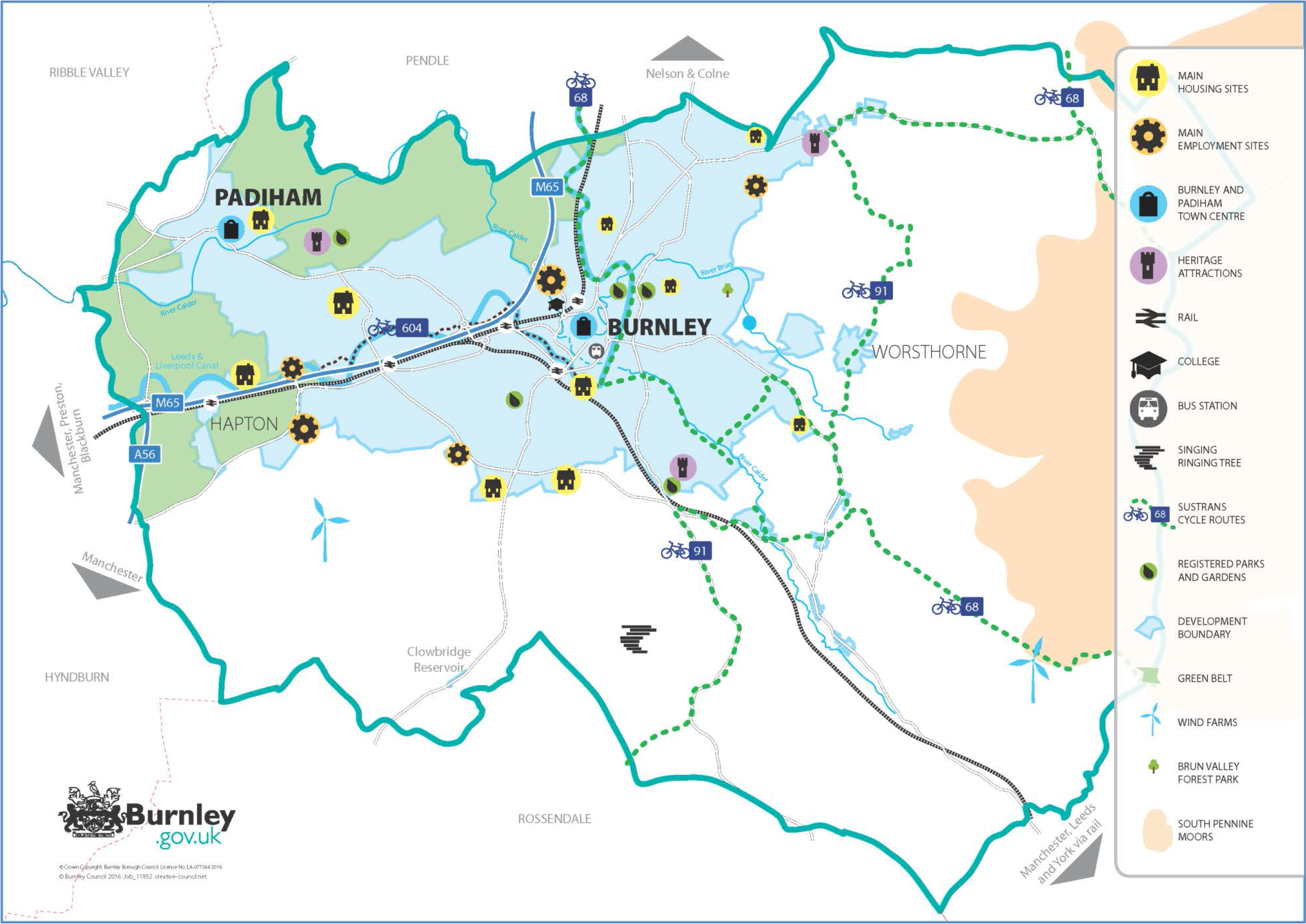
Figure 4: Key Diagram
Policies in this Section:
| SP1: Achieving Sustainable Development | SP5: Development Quality & Sustainability |
| SP2: Housing Requirement 2012-2032 | SP6: Green Infrastructure |
| SP3: Employment Land Requirement 2012-2032 | SP7: Protecting the Green Belt |
| SP4: Development Strategy |
Sustainable Development
4.1.1 Resolution 42/187 of the United Nations General Assembly defined sustainable development as “meeting the needs of the present without compromising the ability of future generations to meet their own needs”. The UK Sustainable Development Strategy Securing the Future (2005) set out five guiding principles of sustainable development: living within the planet’s environmental limits; ensuring a strong, healthy and just society; achieving a sustainable economy; promoting good governance; and using sound science responsibly.
4.1.2 The NPPF sets out the Government’s view of what sustainable development in England means in practice for the planning system. It identifies three dimensions of sustainable development which the planning system should support:
4.1.3 These roles are interdependent. To achieve sustainable development, economic, social and environmental matters should be considered jointly and balanced through the planning system.
4.1.4 The NPPF sets out a presumption in favour of sustainable development which should be seen as a golden thread running through both plan-making and decision-taking.
4.1.5 The NPPF at paragraph 15 states that: “Policies in Local Plans should follow the approach of the presumption in favour of sustainable development so that it is clear that development which is sustainable can be approved without delay. All plans should be based upon and reflect the presumption in favour of sustainable development, with clear policies that will guide how the presumption should be applied locally.”
4.1.6 The Burnley Borough Local Plan is the starting point for the determination of relevant planning applications and these must be determined in accordance with the development plan unless material considerations indicate otherwise.16
4.1.7 The NPPF makes it clear that local planning documents should reflect the presumption in favour of sustainable development and Policy SP1 responds to this requirement.
Policy SP1: Achieving Sustainable Development
| 1) When considering development proposals, Burnley Borough Council will take a positive approach that reflects the presumption in favour of sustainable development set out in the National Planning Policy Framework. It will work proactively with applicants and to find solutions which mean that proposals can be approved wherever possible to secure development that improves the economic, social and environmental conditions of the Borough. 2) Planning applications that accord with the policies in this Local Plan (and, where relevant, with policies in any neighbourhood development plans) will be approved without delay, unless material considerations indicate otherwise. 3) Where there are no policies relevant to the application or relevant policies are out of date at the time of making the decision, the Council will grant permission unless material considerations indicate otherwise - taking into account whether:
|

Photo - Leeds & Liverpool Canal
Objectively Assessed Need
4.2.1 The NPPF (paragraph 159) indicates that local planning authorities should prepare a Strategic Housing Market Assessment (SHMA) in order to gain a clear understanding of housing needs in their areas. It also indicates (paragraph 47) that local planning authorities should use their evidence base “to ensure that their Local Plan meets the full, objectively assessed housing needs for market and affordable housing in the housing market area” in so far as this is consistent with the other policies in the NPPF. The housing target for the borough must be set out in the Local Plan.
4.2.2 The NPPF states that SHMAs should identify the scale and mix of housing and the range of tenures that the local population is likely to need over the plan period which:
The Burnley and Pendle Strategic Housing Market Assessment (SHMA)
4.2.3 A SHMA has been prepared jointly with Pendle Borough Council in recognition of the fact that the two boroughs form a single Housing Market Area (HMA). The SHMA examines the inter- relationships between the HMA and adjacent areas and clearly indicates that the surrounding districts operate as separate housing markets.
4.2.4 The SHMA includes an assessment of housing need and demand for the whole HMA as well as for each borough, and sets out the likely housing requirement for the two boroughs over the respective plan periods. The SHMA tests a number of future scenarios based on different demographic, economic and policy/supply factors.
4.2.5 The Burnley & Pendle SHMA first prepared in December 2013 is now in a number of separate documents due to the different stages the two Councils were at with regard to plan- making. For Burnley Borough, the SHMA of June 2016 and its October 2017 Addendum is the most up to date version.
4.2.6 The NPPF and National Planning Practice Guidance (NPPG) both indicate that the latest population and household projections18 should be used as the starting point for assessing the future housing needs through the SHMA.
4.2.7 The SHMA uses these data sources and then tests a number of different scenarios to establish the Objectively Assessed Need ‘OAN’ (i.e. demand) for housing over the Plan period 2012- 2032 including: a number of demographic (population driven) scenarios to see how much housing would be required to meet the projected population change and its characteristics; and a number of economic (jobs led) scenarios to see how much housing would be required to meet the projected levels of job growth, making assumptions about the likelihood and/or desirability of Burnley based residents filling the jobs.
4.2.8 The scenarios also make assumptions about the number of dwellings required to meet the estimated number of new households and assume a rate for second homes and vacancies of 6.42%.
4.2.9 The SHMA also considered whether any uplifts were needed to the scenario outputs to meet the guidance set out in the NPPG and concluded this was the case for the demographic scenarios to assist with the provision of affordable housing at a rate of 10%.
4.2.10 The 2017 SHMA Addendum identified an OAN range from within its overall scenario range as 2,060 to 4,000 net additional dwellings over the plan period, equivalent to 103 to 200 dwellings per annum (dpa).
4.2.11 The SHMA findings in relation to affordable housing are set out in section 5.1 and Policy HS2.
Establishing the Housing Target
4.2.12 In determining the Plan’s housing requirement figure from the OAN range identified in the SHMA, it is important to ensure that the requirement:
4.2.13 The housing market and local economy are intrinsically linked. It is important to have a sufficient supply of homes to attract and retain a skilled workforce, to enable residents to have a choice of employment opportunities within easy reach and to help prevent unsustainable levels of commuting.
4.2.14 New housing is in itself critical to attracting investment into the local economy, creating new jobs in construction and the supply chain and improving community infrastructure. It is therefore important that the Local Plan provides for sufficient housing to meet the need and demand for housing and to attract and retain economically active residents who will contribute to the long term economic growth and social wellbeing of the borough.
4.2.15 National Planning Practice Guidance (NPPG): Assessment of Housing and Economic Development Needs states that “the assessment of development needs is an objective assessment based on facts and unbiased evidence. Plan makers should not apply constraints to the overall assessment of need, such as limitations imposed by the supply of land for new development, historic under performance, infrastructure or environmental constraints. However, these considerations will need to be addressed when bringing evidence bases together to identify specific policies within development plans.”
4.2.16 Once the OAN is established, therefore, the decision about the level of growth to be set out in the Plan can take into account the ‘environmental capacity’ of borough to accommodate the OAN. The Burnley SHLAA indicates that there is no need to seek delivery in adjacent boroughs and that the borough can meet its own objectively assessed needs for housing in full.
4.2.17 The NPPF (paragraph 162) requires local planning authorities to work with infrastructure providers to assess the quality and capacity of local infrastructure provision and its ability to meet forecast demands. It is necessary to look at whether existing infrastructure can cope with the identified level and distribution of new housing development and/or whether proposed infrastructure improvements will adequately address any identified problems. There are no known major infrastructure barriers to delivering new housing in the borough.
4.2.18 The Local Plan has identified a housing requirement/target based on Scenario Ei of the 2017 SHMA Addendum (Experian Job Growth plus PCU19) i.e. the top of the OAN range but with a more positive assumption in respect of vacancies in new stock and small allowance for second homes, totalling 3.5% giving a requirement of 3,880 net additional dwellings which equates to an indicative average of 194 dwellings per annum.
Policy SP2: Housing Requirement 2012-2032
| 1) Over the 20 year period from 2012 to 2032 provision will be made to deliver a minimum of 3,880 net additional dwellings, equating to an indicative average of 194 dwellings per annum. | ||
| a) | Net additional dwelling requirement 2012- 2032 | 3,880 |
| b) | Completions: 1 April 2012 to 31 March 2017 | (872) |
| c) | Demolitions: 1 April 2012 to 31 March 2017 | (199) |
| d) | Net Additional Dwellings provided: 1 April 2012 to 31 March 2017 [b) minus c)] |
673 |
| e) | Re-occupation of empty homes 1 April 2012 to 31 March 2017 | 148 |
| f) | Commitments: | |
| i) | Of which number of remaining units on sites under construction as at 31 March 2017 |
678 |
| ii) | Of which developable sites with planning permission under the 0.4 ha allocation thresholds as at 31 March 201720 | 114 |
| iii) | Other Commitments21 | 51 |
| g) | Allowance for brownfield Windfalls on sites under 0.4 ha from 1 April 2019 to 31 March 203222 | 338 |
| h) | Re-occupation of empty homes | 80 |
| i) | Residual Requirement to be met by site allocations | 1,798 |
| 2) The housing requirement will be provided for in line with the overall Development Strategy identified in Policy SP4. | ||
Delivering the Housing Requirement
Strategic Housing Land Availability Assessment (SHLAA)
4.2.19 The NPPF (paragraph 159) requires local planning authorities to prepare a Strategic Housing Land Availability Assessment (SHLAA) to establish realistic assumptions about the availability, suitability and likely economic viability of land to meet the identified need for housing over the plan period. Paragraph 161 encourages authorities to undertake assessments of land available for economic development at the same time as, or combined with, the housing SHLAA.
4.2.20 The Burnley Strategic Housing and Economic Land Availability Assessment (SHLAA) 2017 is a combined assessment which assesses the amount of land available within the borough that is potentially available to meet the identified need and demand for new employment and housing development.
4.2.21 The NPPF requires (paragraph 47) that the Local Plan, in meeting the requirement set out, ensures that a five-year supply of specific ‘deliverable’ sites is identified and updated annually. In addition, where there has been persistent under-delivery of new housing, the five-year supply should also include a 20% buffer ‘moved forwards from later in the plan period’ to ensure choice and competition in the market for land. This buffer is not an addition to the overall plan requirement.
4.2.22 The Burnley SHLAA (2017) provides details of the amount of land with the potential to accommodate new housing development. Consideration of a site in the SHLAA or it being categorized as potentially ‘developable’ does not mean that the site will or should be allocated for development, or that a planning application would be supported. The SHLAA provides a pool of potential sites from which to select those to be allocated in the Plan and these were selected on the basis of many factors, including:
4.2.23 The sites allocated for development are set out in Policy HS1.
Housing Trajectory
4.2.24 The NPPF (paragraph 47) requires local planning authorities to illustrate the expected rate of housing delivery in their Local Plan through a ‘housing trajectory’. The housing trajectory is set out in Appendix 5.
4.2.25 The trajectory indicates that the Plan provides for a sufficient supply to deliver the overall housing requirement in the borough and a five year supply of deliverable sites.
4.2.26 The trajectory illustrates that since the start of the Plan period (1 April 2012) the number of net additional dwellings delivered has been below the indicative cumulative requirement figure of 194 dpa. Between 2012/13 and 2016/17 there was a cumulative deficit of 149 dwellings. This under-delivery needs to be addressed by the Local Plan, either in the next five year period (‘Sedgefield’ approach) or over the remaining Plan period (‘Liverpool’ approach).
4.2.27 Housing delivery since the start of the Plan period has been affected by adverse economic conditions which have delayed construction on a number of sites. In addition, the net additional dwellings figures have been impacted upon by the Housing Market Renewal clearance programme in Daneshouse, Burnley Wood and South West Burnley. Economic constraints are likely to continue in the short to medium term and may continue to suppress housing completions; however, the housing market renewal clearance programme has been substantially completed and the building of new and replacement homes continues. The last two years (2015/16 and 2016/17) have seen an upturn in starts and completions.
4.2.28 The SHLAA will be regularly updated and the Authority's Monitoring Report (AMR) will annually update the housing trajectory helping to ensure a five year supply is maintained throughout the Plan period and signalling any need for intervention and/or Plan review.
Empty homes
4.2.29 The NPPF (paragraph 51) indicates that local planning authorities should identify and bring back into residential use empty homes and buildings in line with empty homes strategies and, where appropriate, acquire property by compulsory purchase. In October 2014, there were 2,458 vacant dwellings in the borough in Burnley, equivalent to 6.06% of the housing stock. This is noticeably higher than the average for England (2.62%). In order for a housing market to function properly there will always be a number of vacant homes to allow sale and refurbishment (‘churn’), normally around 3%. 4.2.30 Targeted action by the Council through the Vacant Property Initiative has helped to reduce the overall vacancy rate and the number of long-term empty properties. The Council has current specific plans to target a further 80 empty properties over the period 2017/18 to 2018/19.
Establishing the Employment Land Requirement
4.3.1 The Burnley Employment Land Demand Study (ELDS) (June 2016) provides an important part of the evidence base to inform the preparation of the Local Plan. This objectively assesses employment land demand in line with the NPPF and Planning Practice Guidance (NPPG) over the Plan period 2012 to 2032. It examines a range of future scenarios which forecast jobs growth in the main ‘B class’23 sectors.
4.3.2 One of the economic scenarios (Key Growth Sectors) takes account of non-local plan ‘policy’ interventions and as such could be seen as not being objective.
4.3.3 These scenarios identify a potential demand for between 66.54 and 103.81 hectares of employment land over the Plan period.
4.3.4 Having considered these scenarios and a number of quantitative and qualitative factors, the Study suggests that the Plan requirement should be within the range of 68 to 104 hectares to 2032.
4.3.5 The selection of a specific employment land requirement for the Local Plan and the choice of sites is dependent upon a number of factors including:
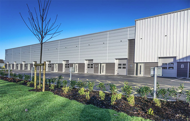
Photo – Phase 1 Vision Park, Burnley - completed 2018
4.3.6 The NPPG: Assessment of Housing and Economic Development Needs states that “the assessment of development needs is an objective assessment based on facts and unbiased evidence. Plan makers should not apply constraints to the overall assessment of need, such as limitations imposed by the supply of land for new development, historic under performance, infrastructure or environmental constraints. However, these considerations will need to be addressed when bringing evidence bases together to identify specific policies within development plans.”
4.3.7 Once the need/demand is established, therefore, the decision about the level of growth to be set out in the Plan can take into account the ‘environmental capacity’ of the borough to accommodate this level of growth.
4.3.8 There are no known major infrastructure barriers to delivering new employment development in the borough.
4.3.9 The Local Plan requirement/target figure is for at least 66 Ha of employment land over the Plan period. This figure aligns with the 2016 ELDS’s Experian Baseline (Jobs Growth) scenario of 82.49 Ha (which is a reflection of recent job growth trends) which in the ELDS was made up of 9.77 Ha plus an allowance for the replacement of employment land losses of 65.2 Ha and a flexibility factor 7.53 Ha.
4.3.10 The Plan requirement based on this Scenario is for 9.77 Ha plus a reduced allowance for past and future losses within the Plan period of 55.8 Ha24. Given the net requirement of this scenario of 9.77 Ha, the significant allowance for losses and the position with regard existing completions, the Local Plan Inspector considered that a further flexibility factor as proposed in the ELDS was not necessary.
Policy SP3: Employment Land Requirement 2012-2032
| 1) Over the 20 year period from 2012 to 2032 provision will be made to deliver at least 66 hectares of employment land. | ||
| a) | Employment Land requirement 2012 - 2032 | 66 Ha |
| b) | Completions - 1 April 2012 to 31 March 2017 | 27.64 Ha |
| c) | Commitments | 10.49 Ha |
| i) | Of which, sites under construction as at 31 March 2017 | 4.57 Ha |
| ii) | Of which developable sites with planning permission under the 0.4 Ha allocation threshold as at 31 March 2017 | 0.33 Ha |
| iii) | Of which Other Commitments25 | 5.59 Ha |
| d) | Residual Requirement to be met by site allocations | 27.87 Ha |
| 2) The employment land requirement will be provided for in line with the overall Development Strategy identified in Policy SP4. | ||
The Focus and Distribution of Development
4.4.1 The Core Principles of the NPPF state that plan-making and decision-taking should, amongst other factors:
4.4.2 Focusing development on urban areas not only helps protect the countryside, but complements efforts to encourage urban regeneration and renaissance to improve the quality of the built environment through the redevelopment and conversion of vacant sites and buildings.
4.4.3 Evidence from the SHLAA indicates that development requirements set out in Policy SP2 and SP3 could not be met in full on previously-developed sites, or on sites within the urban boundary as defined in the 2006 Burnley Local Plan; and that a number of sites outside of the 2006 urban boundary were required to meet the housing and employment land requirements and to deliver housing quality and choice to support economic growth. The focus of development, however, remains on the towns of Burnley and Padiham, on sites within the current built-up areas and on sites adjoining and well related to them.
4.4.4 The borough’s open countryside provides a visually striking and attractive setting for Burnley and Padiham and its villages and hamlets. There are strong pressures for development in the countryside and strict control of the scale and location of development is needed in rural areas to protect agricultural land, landscape, wildlife, recreational opportunities and the character of rural settlements; and to prevent these settlements coalescing. However, some development can and should be supported in rural settlements and in the countryside to support the rural economy, to help sustain infrastructure and services, and to provide quality and choice of housing for existing and new residents.
The Settlement Hierarchy
Burnley
4.4.5 In the previous Lancashire Structure Plan26 the town of Burnley was identified as one of five ‘principal urban areas’ where development in Lancashire should be concentrated. In the former Regional Strategy27 Burnley was identified as a regional town within the Central Lancashire city region (the third priority after the centres of, and inner urban areas of, Manchester and Liverpool), where development should be focused in and around the centre of the town.
Padiham
4.4.6 In the previous Lancashire Structure Plan the market town of Padiham was identified as a Key Service Centre (KSC) where development of an appropriate scale would be sufficient to promote its regeneration and support and enhance its role as a service centre and public transport hub for the surrounding villages and rural areas. These KSCs sat third in the development hierarchy below the Principal Urban Areas (e.g. Burnley and Blackburn) and the Main Towns (e.g. Darwen). KSCs were described but not named in the former Regional Strategy, but Padiham would have fulfilled this role, which was similar to that described in the former Structure Plan.
Villages
4.4.7 The previous Lancashire Structure Plan did not identify specific settlements below the level of KSCs but anticipated that Local Plans would identify villages and settlements for development of an appropriate scale aimed at meeting local needs. The Regional Strategy identified a tier of settlement below KSCs called Local Service Centres (LSC). Again, these were not named as they were to be identified in district-level plans. These were to be towns or villages which already provided a limited range of services to the local community and to be areas of small scale development to help sustain local services, meet local needs, or support local businesses.
4.4.8 A Rural Masterplanning Study for the borough (with the enabling support of CABE) was undertaken in 2011 in order to investigate where housing and other development could be located to support growth and the sustainability of rural settlements. It focused on issues of urban design and land use and set out character and landscape appraisals in order to determine the physical capacity for development in the borough's villages. An updated assessment of village services has been undertaken for the Local Plan and this is included in Appendix 6.
Identifying the New Hierarchy
4.4.9 Whilst the 2006 Burnley Local Plan identified Burnley and Padiham as being within a single urban area boundary which also included the villages of Hapton and Worsthorne, individual Plan policies recognised the different roles and functions of the settlements and took a different approach to the type and scale of development they could support. The Plan did not identify key or local service centres but adopted an approach of ‘named settlements’ in the rural area i.e. settlements outside the urban area where small scale development, subject to a number of caveats, would be supported. Outside of these named settlements the Local Plan proposed that development be strictly controlled.
4.4.10 In view of the need for significant employment and housing development outside of the 2006 urban boundary and also for modest growth to provide new homes to increase housing quality and choice in the borough’s villages, the approach of the 2006 Local Plan has been reviewed. A clear settlement hierarchy is proposed to be set out to reflect and inform the overall plan strategy and help manage development pressures, particularly in view of the NPPF’s approach to housing development which seeks to boost significantly the supply of housing including by meeting in full the need and demand for affordable and market housing.
Development Boundaries
4.4.11 Whilst the 2006 Burnley Local Plan identified an ‘urban boundary’, settlement or development boundaries for the named settlements were not defined.
4.4.12 Whilst this approach provided a framework for allowing small scale development in the named settlements, it provided very limited opportunities for new housing and other development within them, and it did not provide the clarity that defined development boundaries could.
4.4.13 Development Boundaries are therefore proposed around the small villages identified as Tier 4 settlements to reflect and inform the overall plan strategy and help manage development pressures. A single Development Boundary is proposed to be retained for Burnley and Padiham and separate Boundaries for Worsthorne and for Hapton. The 2006 urban boundary has also been reviewed to take account of any relevant allocations at Burnley, Padiham, Hapton and Worsthorne.
4.4.14 These Development Boundaries are not purely housing-focused. They are not intended to be settlement boundaries indicating the existence or extent of villages, but a planning tool to indicate where infill development of an appropriate type and scale may be acceptable; with land outside them being regarded as open countryside.
The Open Countryside
4.4.15 Development within the open countryside will be strictly controlled and will only be permitted where it has a genuine need to be located in the countryside and is of an appropriate scale and type. Policies on these developments are set out elsewhere in the Plan based on the development type e.g. Agricultural Workers Dwellings - Policy HS6, House Extensions and Modifications - Policy HS5, Conversion of Rural Buildings - Policy EMP6. Additional restrictions will apply to development within the Green Belt (see Policy SP7).
4.4.16 Whilst the NPPF does encourage the reuse of previously-developed (brownfield land) providing that it is not of high environmental value, it also seeks to boost significantly the supply of housing and meet the demand for housing and employment land in full. Para 4.4.3 above recognises the need to allocate greenfield land to accommodate the borough’s housing and employment development requirements and deliver the Plan objectives. Policy SP4 does not, therefore, propose a sequential test which seeks to prevent the development of greenfield land where brownfield land exists.
Policy SP4: Development Strategy
| 1) Development will be focused on Burnley and Padiham with development of an appropriate scale also supported in the following main and small villages: Settlement Hierarchy: |
|||
| Tier | Category | Settlement | |
| 1 | Principal Town | Burnley | Role & Function: Principal service centre for the Borough and home to the majority of the borough’s population and a town of a sub-regional importance for retail, leisure and public administration and services with excellent public and private transport links. |
| Development Scale Housing: Large scale, major and a variety of smaller sites to deliver a comprehensive range of choice of types and tenures. Employment: Large scale, medium and a variety of smaller sites to deliver a comprehensive range of units for new and existing businesses and employment opportunities for new and existing residents. Retail: Sub regional centre for retailing and the principal retail destination for the borough. Town centre with defined Town Centre boundary and defined Primary Shopping Area and Primary and Secondary Frontages where new development will be concentrated including through a new allocation and by virtue of its size. |
|||
| 2 | Key Service Centre | Padiham | Role & Function: A key service centre and public transport hub for the surrounding villages and rural areas and home to a significant proportion of the borough’s population. |
| Development Scale Housing: Large scale, major and a variety of smaller sites to deliver a comprehensive range of choice of types and tenures. Employment: Large scale, medium and a variety of smaller sites to deliver a comprehensive range of units for new and existing businesses and employment opportunities for new and existing residents. Retail: Town centre with defined Town Centre boundary with a supporting role to Burnley in the retail hierarchy where by virtue of its smaller size, more modest development would be focussed. |
|||
| 3 | Main Village | Hapton Worsthorne | Role & Function: Predominantly residential areas but with some local employment sites, which provide a limited but reasonable range of services to the local community and local businesses and have good public and private transport links to larger towns. |
| Development Scale Housing: Medium and small scale sites to deliver quality and choice and modern adaptable stock for existing and new residents and to deliver aspirational housing and support and enhance existing service provision. Employment: Small scale schemes to provide opportunities for new and existing businesses and employment opportunities for new and existing residents. Retail: No defined centre – local shops to serve local community |
|||
| 4 | Small Village | Clow Bridge Mereclough Lane Bottom Hurstwood Overtown Holme Chapel Walk Mill |
Role & Function: Predominantly residential areas but with some small scale local/rural employment sites, which provide a basic range of services to the local community and local businesses and have reasonable public and private transport links to larger towns and villages. |
| Development Scale Housing: Small scale schemes to deliver quality and choice and modern adaptable stock for existing and new residents and support and enhance existing service provision. Employment: Limited small scale schemes to provide opportunities for new and existing rural businesses or rural diversification and employment opportunities for new and existing residents. Retail: No defined centre – local shops or facilities selling basic convenience goods to serve local community. |
|||
| Development Boundaries and development within them 2) In addition to those sites specifically allocated for development in policies elsewhere in this Plan, new development will be supported within the Development Boundaries as defined on the Policies Map where it is of an appropriate type and scale bearing in mind the role of the settlement in the hierarchy and where it satisfies the following overarching criteria and other relevant policies of this Plan:
3) In considering the acceptability of development proposals on unallocated sites within these Development Boundaries, consideration will also be given to:
Development in the Open Countryside 4) The open countryside is defined as land beyond any Development Boundary. In the open countryside development will be strictly controlled. Coalescence 5) Development proposals should not lead to the coalescence of settlements. |
|||
4.5.1 Section 39 of the Planning and Compulsory Purchase Act 2004 requires local planning authorities to exercise their plan-making functions “with the objective of contributing to sustainable development”. Section 19 (1A) of the Act requires them to include in their local plans “policies designed to secure that the development and use of land in the local planning authority’s area contribute to the mitigation of, and adaptation to, climate change.”
4.5.2 The Core Principles of the NPPF state that plan-making and decision-taking should “support the transition to a low carbon future in a changing climate, taking full account of flood risk and coastal change, and encourage the reuse of existing resources, including conversion of existing buildings, and encourage the use of renewable resources (for example, by the development of renewable energy).”
4.5.3 The Lancashire Climate Change Strategy28 sets out a framework for how the sub-region will work together towards meeting its target that Lancashire is low carbon and well adapted by the 2020, and identifies the carbon savings that can be achieved through four key sectors: domestic; transport; business and public sector; and land use.
4.5.4 Whilst the location and focus for new development is important in reducing the demand for fossil fuels and minimising emissions, the design, layout and orientation of buildings and open spaces can also make a positive contribution to improving the overall sustainability of new development by minimising or avoiding negative on or off-site environmental impacts and through minimizing both the embodied energy costs and the energy usage of new development.
4.5.5 Paragraph 95 of the NPPF states local planning authorities should actively support energy efficiency improvements to existing buildings and when setting any local requirement for a building’s sustainability, do so in a way consistent with the Government’s zero carbon buildings policy and adopt nationally described standards.
4.5.6 In terms of minimising embodied energy costs and the energy usage in new development, the Government now proposes that the mechanism for achieving the requirements of this policy is through an incremental increase in the mandatory energy efficiency requirements of the Building Regulations (Part L). However, planned improvements to Part L building fabric energy standards in 2016 have not been implemented and current standards are being instead “will keep energy efficiency standards under review”.29
4.5.7 In March 2015 the Government introduced a new approach to establish planning and building regulation technical standards for homes, in an attempt to rationalise a number of pre- existing standards e.g. the Code for Sustainable Homes and Lifetime Homes, into three ‘Optional Standards’; two within the Building Regulations themselves and the third an optional nationally described space standard. These optional standards cover three matters, accessibility, water efficiency and internal space. Councils can through their Local Plans introduce the one or more of the optional standards where they address a clearly evidenced need and where their impact on viability has been considered; and can set out what proportion of new dwellings should comply with the standards. Guidance on introducing the standards is set out in the NPPG.
4.5.8 Water Efficiency: Under the basic standard set out in the Building Regulations, all new homes have to meet the requirement of 125 litres/person/day. There is not considered to be sufficient evidence to support the optional higher standard of 110 litres/person/day.
4.5.9 Internal Space: It is not considered that there is sufficient clear evidence to introduce the optional nationally prescribed space standard although this is an important issue in Burnley given the oversupply of small two bedroomed terraced homes without indoor ground floor toilets.
4.5.10 Accessibility: It is considered that there is sufficient evidence as set out in the Council’s SHMA to support the optional standard on accessibility. There are two optional accessibility standards: M4(3) wheelchair user dwellings and M4(2) wheelchair adaptable dwellings (i.e. those which are constructed with the potential to be adapted for occupation by a wheelchair user). It is the latter, which addresses similar matters to the former non-statutory Lifetime Homes standards, that is considered appropriate in Burnley. This is set out in Policy HS4.
4.5.11 The changes to the standards for housing do not affect those for commercial buildings where BREEAM standards are still relevant (Building Research Establishment Environmental Assessment Methodology). First published by the Building Research Establishment in 1990 BREEAM is the world’s longest established method of assessing, rating, and certifying the sustainability of buildings. More than 250,000 buildings have been BREEAM certified and over a million are registered for certification – many in the UK and others in more than 50 countries around the world.30
4.5.12 Whilst the Council recognises that the viability of new development may be affected by unduly onerous policy requirements, important matters such as improved adaptability and energy efficiency can be addressed without compromising viability and the Plan needs to look at viability across the economic cycle to 2032. Lower running costs, particularly in terms of energy is an important factor in areas such as Burnley where there are high levels of fuel poverty.
Design Quality
4.5.13 Section 39 of the Planning and Compulsory Purchase Act 200431 requires local planning authorities to “have regard to the desirability of achieving good design”. One of the 12 core planning principles set out in the NPPF is to “always seek to secure high quality design and a good standard of amenity for all existing and future occupants of land and buildings”.
4.5.14 Definitions of good design are many and varied. Design is often interpreted to be solely about appearance, but good design must also take account of functionality. High quality design is design which positively addresses its context, local character, appropriate scale and form, continuity and enclosure, quality of the public realm, ease of access, legibility, adaptability and affordable maintenance, and uses high quality materials and methods of construction.
4.5.15 The borough’s industrial legacy and natural topography has created an interesting and distinctive townscape, recently enhanced by high quality new developments and refurbishments around the town such as at the Weavers’ Triangle. It is important that new development, of whatever type and scale, respects the area’s character and seeks to achieve high quality design and where possible improvement in the built environment to help create attractive and successful neighbourhoods and thriving town centres. Simple elegant designs are generally preferable to over- designed or ‘fussy’ schemes, but there is always a place for idiosyncrasy and for creating new landmark buildings and structures, particularly as many of these (mills and chimneys, church towers and spires) can be been lost over time.
Key Gateways
4.5.16 The image or perception of a town can be formed by a visitor’s experience on their first approach to it. For residents, their pride and enjoyment of their own town will also be affected by their approaches to and journey across it. The quality of key entrances to and key junctions across the town that people pass daily is important to the town’s overall image and can also set the tone for other development in the town and on routes between these key gateways. Key gateways can serve different functions and should not all be treated the same; some should proudly announce your arrival, whilst other should provide a smooth and gentle transition from countryside to town. In order to protect and enhance them for the wider benefits they bring, the Council has identified the location of the Key Gateways on the Policies Map.
Materials
4.5.17 The choice of materials is important to any new development, including extensions and alterations to existing buildings. The choice of materials, their colour, texture and pattern of use has a major impact on the way a development looks and can help articulate and communicate a sense of quality and belonging. A limited and carefully selected palette of materials appropriate to the locality is most effective and the use of high quality durable materials will lead to the most sustainable and successful developments.
Security
4.5.18 Designing out crime and designing in community safety should be central to the planning and delivery of new development. Section 17 of the Crime and Disorder Act 1998 requires all local authorities to exercise their functions with due regard to their likely effect on crime and disorder, and to do all they reasonably can to prevent crime and disorder. The role of the planning system in helping to secure safe and accessible environment is in paragraphs 58 and 69 of the NPPF.
4.5.19 One tool in helping to achieve this is ‘Secured by Design’ (SBD). SBD is an initiative managed by the Mayor’s Office for Policing and Crime (MOPAC) on behalf of the UK police services which awards this accreditation to schemes which are designed and laid out to address a range of crime prevention initiatives.
Accessibility
4.5.20 The Equality Act 2010 requires service providers to make reasonable adjustment where disabled customers or potential customers would otherwise be at a substantial disadvantage compared with non-disabled people. This can include making changes to the structure of a building to improve access and to provide auxiliary aids and services. The Council will support, wherever possible, adaptations to existing buildings, subject to balancing this with any other important policy imperatives. New buildings should be designed from the outset with all users in mind.
Building for Life
4.5.21 ‘Building for Life 12’ is a Government-endorsed industry standard for well-designed homes and neighbourhoods led by three partners: CABE at the Design Council, Design for Homes and the Home Builders Federation, supported by Nottingham Trent University. It uses 12 urban design criteria and a ‘traffic light’ system whereby developments that achieve 9 ‘greens’ are eligible for ‘Built for Life’ accreditation. Schemes that achieve 12 greens will be eligible to be awarded Built for Life ‘Outstanding’ status, and the best new housing across the country will be recognised at events organised by the Building for Life Partnership.
Active Design
4.5.22 Good design should contribute positively to making places better for people, to create environments that make the active choice the easy and attractive choice for people and communities. Policy SP5 and other policies in the Local Plan reflect this important aspiration. Further information can be found in ‘Active Design’ prepared by Sport England, which is a key guidance document intended to help unify health, design and planning by promoting the right conditions and environments for individuals and communities to lead active and healthy lifestyles.
Policy Approach
4.5.23 Policy SP5 provides a comprehensive strategic policy framework for design which will be applied to all development as appropriate to its particular nature and scale. This should be read alongside any specific policies elsewhere in the Plan applying to the development type, for example housing, or subject e.g. landscape character, parking etc.; and additional area or topic-specific design guidance may be set out in future Supplementary Planning Documents.
4.5.24 Whilst the delivery of high standards of design and construction can affect development costs, much can be achieved by careful thought and the limited use of high quality natural local materials. High quality design and materials will have lower maintenance costs over the lifetime of developments.
4.5.25 Development proposals, as appropriate to their nature and scale, will be expected to demonstrate through the use of detailed, clear and accurate drawings (and a Design and Access Statement where appropriate), how they have successfully addressed their context.
Policy SP5: Development Quality and Sustainability
| The Council will seek high standards of design, construction and sustainability in all types of development. Proposals will be expected to address the following minimum requirements, as appropriate to their nature and scale: 1) Energy Efficiency
2) Design and Layout
3) Key Gateways
4) Materials
5) Accessibility
6) Security
|
4.6.1 The NPPF defines green infrastructure as a network of multi-functional green space, urban and rural, which is capable of delivering a wide range of environmental and quality of life benefits for local communities.
4.6.2 Green Infrastructure (GI) is not simply an alternative description for conventional open space. As a network it includes parks, open spaces, playing fields, woodlands, but also street trees, allotments and private gardens. It can also include streams, canals and other water bodies (Blue Infrastructure) and features such as green roofs and walls.
4.6.3 The NPPF states that local planning authorities should set out a strategic approach in their Local Plans, planning positively for the creation, protection, enhancement and management of networks of biodiversity and green infrastructure (para 114).
4.6.4 The NPPG identifies how GI can help support a number of planning policies including:
Burnley’s GI Strategy
4.6.5 The Council published the Burnley Green Infrastructure Strategy in September 2013. This Strategy describes the GI assets of the borough, the functions and benefits they provide and a strategy for improvement.32 This complements the Council’s Green Spaces Strategy which categorizes the types of Council owned open space in the borough, assesses its quantity, quality and accessibility, identifies any areas of deficiency and sets out the Council’s approach to the management of its open spaces.
4.6.6 The GI Strategy identifies 11 functions of GI and divides the GI assets into 17 types (see Table 2). Each type may fulfil one or more function.
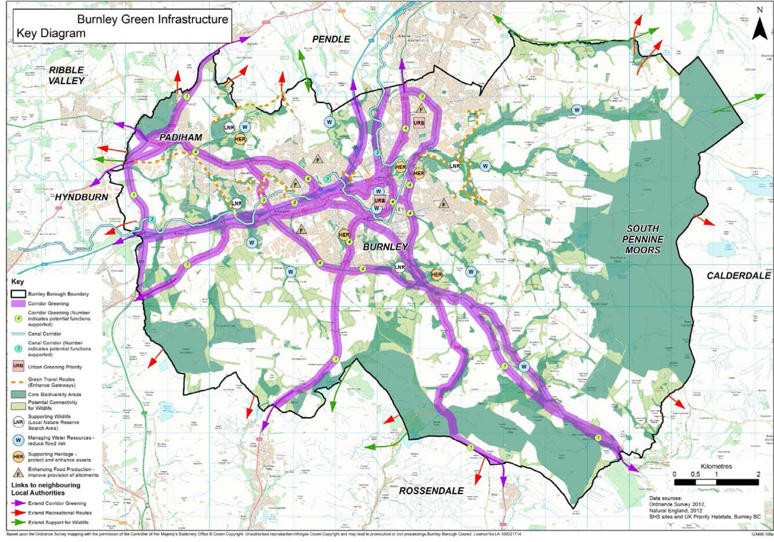
4.6.7 The GI strategy identifies the key assets and opportunities (See Figure 5) and highlights the corridor greening of the borough’s main road infrastructure as a key opportunity for delivering a number of GI functions, including: aesthetic value, supporting wildlife, shading from the sun, trapping air pollutants and noise absorption. The Leeds & Liverpool Canal corridor is identified as another linear corridor with opportunities for delivering multiple GI functions, including: green travel routes, supporting heritage and supporting wildlife.
4.6.8 Two areas of urban greening priority are identified for their need for a number of GI interventions - North Burnley and Burnley town centre. Off-road green travel routes are mapped with the recommendation to raise awareness of these routes through improvements to key gateways.
4.6.9 The Local Plan has an important role to play in protecting and enhancing GI and the wide range of environmental and quality of life benefits it brings for local communities. New development should seek to protect, maintain and enhance GI wherever possible. Much of this will be achieved through a number of individual policies e.g. a requirement for the protection of or provision of new play and recreation space in housing developments (HS4), the protection of the Green Belt (SP7), community infrastructure (IC5) open spaces (NE2), Ecological Networks (NE1) etc. and through the overall development strategy set out in SP4. Given the multi-functional nature of GI, however, the Council will expect developments to look at GI comprehensively and will develop a GI Audit checklist to assist with this process. For major developments and/or those requiring an Environmental Impact Assessment (EIA) an audit taking account of the Council’s GI Strategy, Green Spaces Strategy and Playing Pitch Strategy where relevant will be expected. For other proposals a ‘light touch’ audit will be required.
Policy SP6: Green Infrastructure
| 1) In line with Burnley’s Green Infrastructure Strategy, the Council will, in partnership with other agencies and stakeholders, seek to protect, enhance and extend the borough’s multifunctional green infrastructure network in order to maintain and develop the wider public health, ecological and economic benefits it provides and to ensure that there is an overall net gain. 2) In addition to satisfying the requirements of other policies, development proposals should, as appropriate to their nature and scale:
|
Table 2: Green Infrastructure Types and Functions
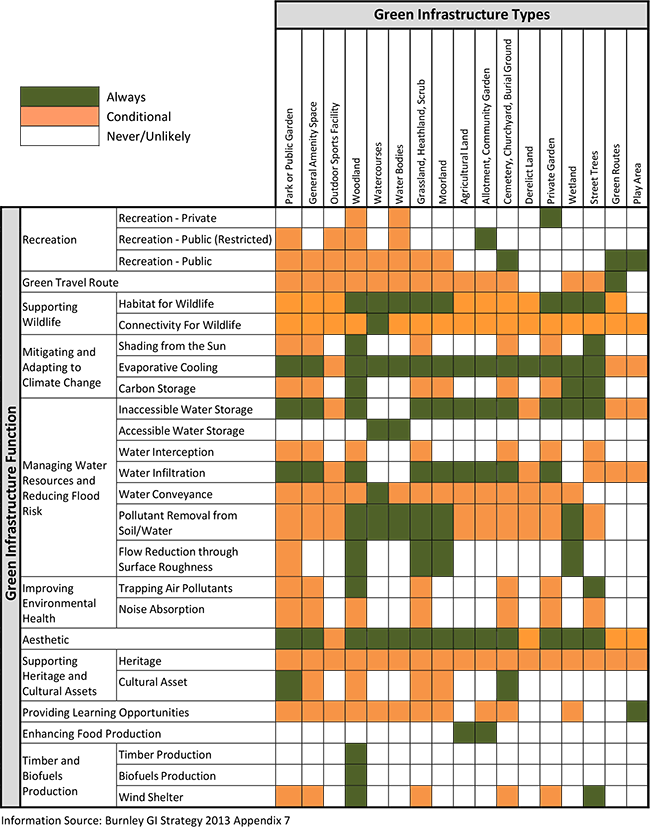
Figure 5: Burnley Green Infrastructure Key Diagram
National Planning Policy Background
4.7.1 The NPPF (para 79) states that “the fundamental aim of Green Belt policy is to prevent urban sprawl by keeping land permanently open; the essential characteristics of Green Belts are their openness and permanence.”
4.7.2 The NPPF sets out five purposes of the Green Belt:
4.7.3 The NPPF states that: “Once established, Green Belt boundaries should only be altered in exceptional circumstances, through the preparation or review of the Local Plan”.
The Borough’s Green Belt
4.7.4 The Council recognises the important role of the Green Belt. It has been a very successful instrument in limiting urban sprawl, preventing the coalescence of settlements and encouraging the reuse of derelict and previously developed land in the urban areas. The general extent of the Green Belt in Lancashire was originally established in the North East Lancashire Structure Plan of 1979; and the boundaries in Burnley were first defined in the 1985 Burnley District Local Plan and had remained unchanged since. The borough had around 1,060 hectares of Green Belt, located in the northern and western parts of the borough.
4.7.5 To inform the Plan, the Council undertook a Green Belt Review 34 which considered, in respect of each parcel of Green Belt land:
4.7.6 It was considered that overall, the Green Belt still fulfilled its purpose and its general extent should be maintained.
4.7.7 An alteration is to be made to its boundary to exclude an area of land which it is considered no longer fulfils green belt purposes. The site of the former Ridgewood School on March Street in Stoneyholme already has outline planning permission for residential development on the footprint of the former school and its particular circumstances in relation to other developments along Oswald Street over time have significantly altered its role in green belt terms. It is, therefore, proposed that this site be removed from the Green Belt.
4.7.8 Land at the Former William Blythe Site (HS1/3) has been granted planning permission for 202 dwellings. Part of this site is within the Green Belt and ‘very special circumstances’ have been demonstrated by the applicant in respect of this particular development scheme. However, the land in question is not proposed to be removed from the Green Belt at this time as there are not currently any ‘exceptional circumstances’ to warrant its removal as it currently fulfils its Green Belt purposes and there are sufficient sites outwith the Green Belt that could meet the identified housing requirement set out in Policy SP2. Should this planning permission be implemented, the land developed for housing will be considered for removal from the Green Belt in any future Plan review.
Policy SP7: Protecting the Green Belt
| 1) The revised extent of the Green Belt is defined on the Policies Map. 2) Within the Green Belt, planning permission will not be granted for ‘inappropriate’35 development except in very special circumstances. The construction of new buildings in the Green Belt is ‘inappropriate’ development. Exceptions to this are:
3) Within the Green Belt, certain other forms of development are also not ‘inappropriate’36 providing they preserve the openness of the Green Belt and do not conflict with the purposes of including land with it. These are:
4) Development that is not ‘inappropriate’ will be judged in relation to the other policies of the Development Plan and any relevant Supplementary Planning Documents. |
16 Section 38(6) of the Planning and Compulsory Purchase Act 2004 and section 70(2) of the Town and Country Planning Act 1990
17 The NPPF gives the following examples: those policies relating to sites protected under the Birds and Habitats Directives and/or designated as Sites of Special Scientific Interest; land designated as Green Belt, Local Green Space, an Area of Outstanding Natural Beauty, Heritage Coast or within a National Park (or the Broads Authority); designated heritage assets; and locations at risk of flooding or coastal erosion
18 ONS Sub-national population projections (SNPP) and DCLG Household Projections
19 See 2017 SHMA Addendum, Scenario Ei - Experian Job Growth plus Partial Catch Up Page 18 plus Erratum Sheet as per Examination Library correction EL3.080
20 An allowance for non-implementation (lapse rate) of 10% has been applied
21 51 further dwellings at Former William Blythe Site within the Green Belt consented under planning application APP/2016/0021
22 based on average rate over a 5 year period 2010/11 to 2014/15 i.e. 26 per annum
23 See Glossary
24 This figure was determined during the Local Plan Examination and was derived from updated information on past and anticipated future losses of employment land over the plan period - see examination library document EL3. 077a
25 Site EMP1/2 Parcel A and EMP1/4 as set out in Proposed Submission Draft Local Plan of March 2017 - these sites were under construction in 2017/18 and were set to be completed by 31 March 2018 i.e. before adoption
26 Joint Lancashire Structure Plan 2001-2016 (2005)
27 North West of England Plan Regional Spatial Strategy to 2021 (2008)
28 Lancashire Climate Change Strategy 2009-2020 The Lancashire Climate Change Partnership adopted by the Lancashire Leaders in 2009
29 HM Treasury - Fixing the foundations: Creating a more prosperous nation - July 2015
30 Wikipedia
31 Introduced by S183 of the Planning Act 2008
32 Burnley Green Infrastructure Strategy 2013 - 2031
33 This is a reproduction of Figure 6.1 from the Burnley GI Strategy of 2013 Page 37. Updated information on some of the assets described in the GI Strategy now exists e.g. the Lancashire Ecological Networks for Woodland and Grassland - see Policies Map
34 Burnley Green Belt Review June 2016 - LUC for Burnley Borough Council
35 See para 89 of NPPF
36 See para 90 of NPPF
< Previous | ^ Top | Next >