
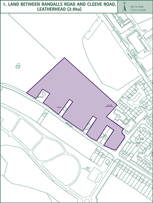
1. Land between Randalls Road and Cleeve Road, Leatherhead
(2.9 ha)
This site is surrounded on three sides by the Metropolitan Green Belt. The Council will require a landscaped buffer within the site along its north and north western boundary to maintain the rural Green Belt setting.
Development on the edges of the site should be at a low density with extensive landscaping. New development should be no higher than two storeys and contain a variety of accommodation including dwellings suitable for young couples, newly formed households, single people and the elderly. The Council will seek to ensure that a proportion of the dwellings is in the form of affordable housing.
The layout of the development will be required to respect the amenities of the five existing dwellings along the Randalls Road frontage of the site. There are several attractive trees within the site and along its western boundary. These should be retained and incorporated into the layout of the housing development.
Access to the site should be provided from Randalls Road at a point between Little Waltons and Farthings. It will be necessary to widen Randalls Road between the site’s entrance and the Cleeve Road junction and provide a new footpath along the north side of the road. A secondary access to the site should be provided via the existing access to the Family Centre from Cleeve Road. There should be no access through the site between Randalls Road and Cleeve Road. The Council will require an area to be made available within the site for a children’s play area, large enough to enable casual pursuits including ball games to take place.
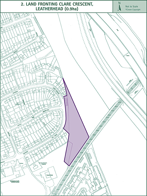
2. Land fronting Clare Crescent, Leatherhead
(0.9 ha)
This triangular-shaped site occupies the corner of a field which is used for grazing. The proposed housing site is flanked to the west by existing housing and to the south by the railway line. The eastern boundary is not defined on the ground but is contiguous with the boundary of the Green Belt. To the east, beyond the remainder of the field is the Leatherhead By-pass and M25 motorway. These roads are on an embankment above the level of the housing site. The layout of the site will be required to have regard to the noise from the By-pass, motorway and railway and the design of dwellings will be expected to include measures necessary to eliminate noise disturbance from these sources. These include acoustic double glazing and dwellings with a single aspect to ensure living rooms are farthest from the noise sources. There are several trees on the site which should be retained.
The site is suitable for flats, semi-detached or terraced dwellings which should not be more than two storeys in height. The Council will negotiate for the provision of an element of affordable housing as part of the scheme.
Access to the site should be provided from Clare Crescent. Ghost islands and right turning lanes will be required at the junction of Kingston Road with Aperdele Road and The Fairway.
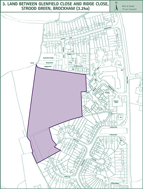
3. Land between Glenfield Close and Ridge Close, Strood Green, Brockham
(3.2 ha)
The land between Glenfield Close and Ridge Close was identified as a reserve housing site in the Dorking Area Local Plan. It comprises fields on the edge of the existing compact residential development at Strood Green.
Development on the western side of the site should be at a lower density, well landscaped and set back from the site’s boundary with the Green Belt countryside to the west to achieve a gradual transition between the rural landscape and the housing development. The Council will also require screen planting in the triangular shaped land between the western site boundary and the existing field boundary slightly further west.
The orientation and layout of development should avoid any overlooking of the existing housing adjoining the site, especially the bungalows to the north which lie close to the site’s boundary. Provision should be made either to retain or relocate within the scheme the existing children’s play area known as the Elizabeth Bailey Field currently under the control of the Brockham Parish Council under a deed of trust and registered with the Charity Commission.
Access to the site shall be provided from Tanners Meadow and an emergency access from Ridge Close.
Development should not exceed two storeys in height and should provide a range of accommodation including that suitable for occupation by young couples, newly formed households and single people. The Council will also seek to ensure that a proportion of the new dwellings is in the form of affordable housing.
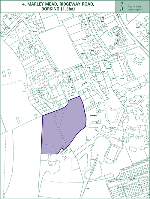
4. Marley Mead, Ridgeway Road, Dorking
(1.3 ha)
This site lies in the Surrey Hills Area of Outstanding Natural Beauty. It is flanked on three sides by the Metropolitan Green Belt.
A buffer of landscaped open land will be required within the site around its west, south and east boundaries to maintain its rural setting.
The existing trees around the site’s boundaries should be retained.
Development around the edges of the site should be at a low density and set in extensive landscaping. The proposed housing should not exceed two storeys in height and should be of a detached design. The layout of the site should have regard to the amenities of the existing dwellings to the north and avoid any overlooking or loss of privacy.
Access to the site shall be provided from Marley Rise.
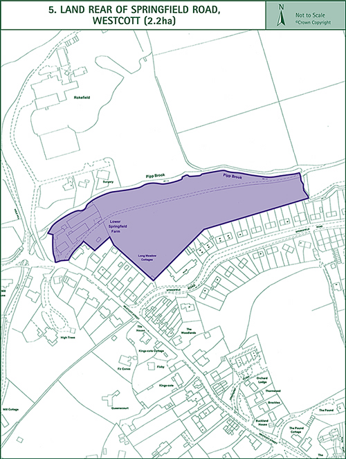
5. Land rear of Springfield Road, Westcott
(2.2ha)
The site lies in the Surrey Hills Area of Outstanding Natural Beauty. The northern and eastern boundaries of the site abut the Green Belt along the Pipp Brook which defines the outer limit of the site.
It is a requirement of the Environment Agency that the design and layout of the site is sympathetic to the Pipp Brook and that a buffer strip of 10 metres is provided between the watercourse and the development. Consultation with the Environment Agency is recommended to ensure the best means of incorporating the stream into the design of the development is achieved.
The layout and density of the site will be required to reflect its rural character and setting in the Area of Outstanding Natural Beauty. It should be designed so that its impact on the adjacent countryside is minimised, especially when viewed from the public footpaths and higher ground to the north. In this regard, and in the interests of preserving the visual amenities of the adjacent Green Belt and the rural character of the locality, a substantial belt of landscaping, comprising native species typical of the area, should be provided along the northern boundary of the site, outside the buffer strip.
The position and orientation of new housing should respect the amenities and avoid any overlooking of the existing dwellings to the south west and south east.
The Council considers that the site is suitable for family housing and should also provide for a proportion of affordable dwellings, the precise amount and type of which will be the subject of negotiation, taking into account the findings of the Council’s housing needs survey.
< Previous | ^ Top | Next >