
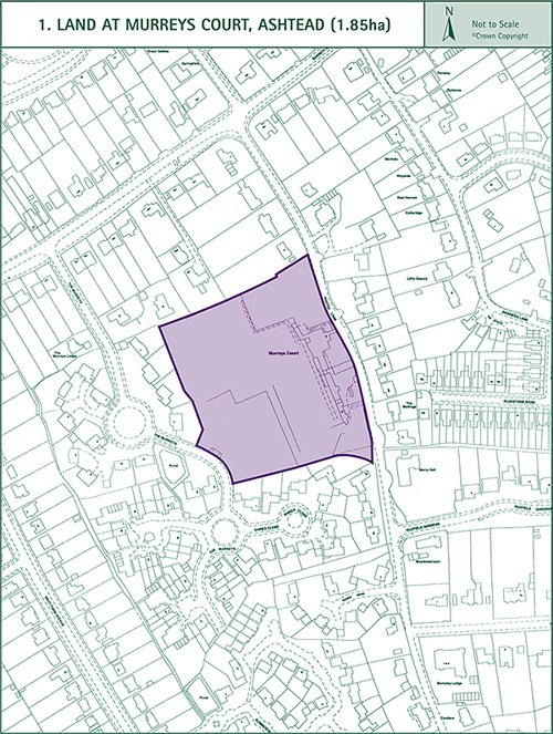
1. Land at Murreys Court
(1.85 ha)
Outline planning permission for the development of this site with 19 detached 4/5 bedroom houses lapsed in August 1990. Part of the site is currently used for grazing and the remainder forms part of the garden to the property known as Murreys Court. Murreys Court, a listed barn, several unlisted outbuildings and a cottage front Agates Lane. A high brick wall runs along the north end of the site’s eastern boundary. The site is covered by a Tree Preservation Order. Development of the site will be expected to reflect the form and character of the adjacent housing development in The Murreys. The brick wall along the Agates Lane frontage should be retained. The cottage should be retained; Murreys Court and the adjacent outbuildings could be converted to small residential units. The listed barn should be retained and re-used. New housing development should not cramp the setting of the Listed Building. The Council will wish to see that as many as possible of the preserved trees are retained and incorporated into the layout of the site. Access to the site will be required to be provided from The Murreys. The junction of The Murreys with Barnett Wood Lane may need improving.
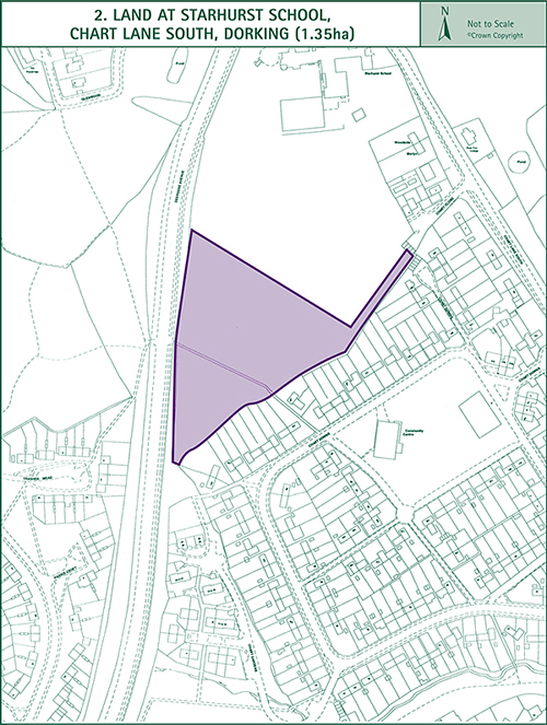
2. Starhurst School, Chart Lane South, Dorking
(1.35 ha)
This site forms part of the grounds of Starhurst School and includes the former allotments to the north of Chart Downs. It is flanked on the west by the A24 Deepdene Avenue and by existing residential development in the south and east. The school’s buildings lie to the north of the site on higher ground. There is a fall across the site from the north west to the south east. The boundary is flanked by attractive belts of trees which are important features in the landscape. There are also several attractive trees along the site’s southern boundary. A public footpath (Right of Way 96) crosses the site between its boundaries with the A24 and Chart Downs. The development of the site will result in the loss of open space in the locality. New housing is also likely to increase the demand for open space and play facilities in the area. The Council will negotiate a planning agreement with the site’s developers which would compensate for the loss of amenity and provide for the additional demand. The Council will look towards the provision of contributions which would be put towards the improvement of play facilities in the area. The layout of the site should be designed to avoid overlooking of dwellings, especially those to the south which are at a lower level. The tree screen along the site’s A24 frontage should be retained and a landscaped buffer strip should be provided between the A24 and any housing. Attenuation measures may be required to mitigate the effects of noise from road traffic on the A24. The site is suitable for a range of house types and the Council will seek to ensure that a proportion of the dwellings proposed are in the form of affordable housing. Access to the site should be provided from Chart Lane South. It may be necessary to widen the road at the point of access to enable satisfactory right-turning movements into the site. No access would be allowed from the A24.
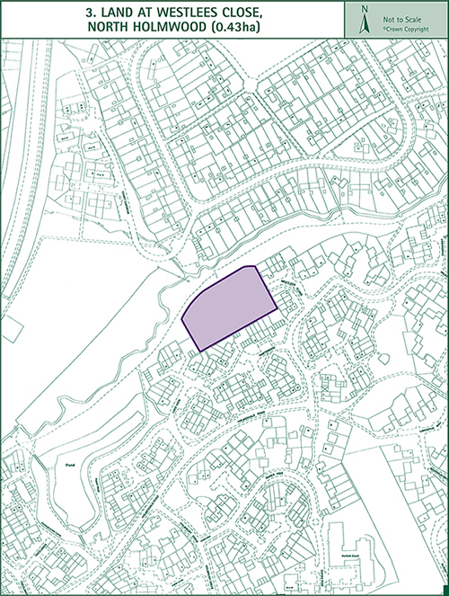
3. Land at Westlees Close, North Holmwood
(0.43 ha)
The land lies on the north side of Holmwood Park adjacent to the public footpath and tree belt running along the northern boundary to the estate. It is owned by Seeboard who had intended it for the provision of a 132/33/11KV electricity sub-station. In this regard whilst permission was granted for the sub-station in 1968 and was later renewed on several occasions, permission was not renewed after 1984 and lapsed in 1987. This site is no longer required for an electricity sub-station. The Holmwood Park housing estate was developed up to and around three of the four boundaries of the site. Had it not been reserved for the electricity sub-station it seems likely it would have been included for housing development. Along the boundaries with Holmwood Park are narrow earth bunds which partially screen the site from the neighbouring residential area. The main part of the site is flat, largely umkempt, grassland that has an appearance of a vacant site. However the northern length of the site has an amenity value with its treed embankment. This part of the site should remain undeveloped and be left as an amenity area in a similar manner to those areas bordering the embankement to the east and west. It is estimated that having regard to the above amenity strip and the density of the neighbouring residential area the site could accommodate about 15 houses. Access would be taken off Westlees Close.
< Previous | ^ Top | Next >