
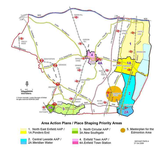
9.1 This chapter sets out the more detailed policies for the strategic growth areas of Central Leeside, North East Enfield, Enfield Town and North Circular area, which were identified in Core Policy 1, and Edmonton. In addition, within these strategic growth areas, the Council is working with partners and communities about place shaping priorities in specific neighbourhoods where the greatest challenges are faced. Place shaping includes not only the physical transformation of places, but also working with partners to improve services, health, housing, education, employment, safety and prosperity. These place shaping priority areas are:
Map 9.1 Areas covered by Area Action Plans and Place Shaping Priority Areas within the Action Plan Areas
9.2 In March 2009, the Council carried out further consultation on the preferred options for these areas.1 The policies in this section build on this consultation undertaken, as well as responses to the Core Strategy Preferred Options document and consultation on early stages of the area action plans. For each of the four strategic areas, the Council’s overall approach is set out, together with specific policy guidance for the priority neighbourhood. This is not intended to provide policy guidance on every aspect of the development, but should be read in conjunction with the Council’s forthcoming policies within the Development Management DPD.
9.3 As part of the consultation undertaken in March 2009 on the Strategic Growth Areas Report and parallel consultation undertaken as part of the Council's Edmonton Area Review, it has emerged that there would be merit in promoting an additional place shaping priority area at Edmonton encompassing the wider area including Angel Edmonton. This would ensure that substantial investment and regeneration activities undertaken in the area to date are built on and the momentum is not lost to secure broader benefits for the community. Edmonton Green and Meridian Water are only a few kilometres apart and there is potential for strong linkages and synergy between the two communities so that regeneration at one complements the other. Core policies for five place shaping priority areas, including Edmonton, are therefore set out in this section.
9.4 Arrangements for the delivery of the following core policies for places will be tailored to meet local circumstances. A Single Implementation Plan guided by the Enfield Strategic Partnership will be established to coordinate the delivery of change in the south east of the Borough (see Core Policy 39). Delivery vehicles will be established for each of Enfield's place shaping priority areas.
9.5 Central Leeside is predominantly an employment area in the south east of the Borough. It is bordered in the east by the Lee Valley Regional Park and to the south by the London Borough of Haringey. The North Circular Road and other road and rail routes through the area tend to dominate it and slice it into poorly connected segments. The area contains some key public facilities including the Edmonton Incinerator and Deephams sewage works which provide essential services to north London. The Regional Athletics Centre at Picketts Lock provides important regional leisure facilities. Whilst the number of people currently living within Central Leeside is low, the existing nearby communities suffer from high unemployment, low skills and many other aspects of deprivation.
9.6 The majority of the industrial estates within Central Leeside are generally well occupied and provide a valuable source of jobs in area such as logistics, warehousing, utilities, motor vehicle repair, wholesale and food and drink manufacturing. However, the decline in traditional industry places continuing pressure on these estates to adapt and modernise so that they are in the best possible position to attract new businesses with the potential to provide for higher paying employment opportunities.
Map 9.2 Area covered by the Central Leeside Area Action Plan, including the Meridian Water Place Shaping Priority Area

9.7 An area of Central Leeside around Meridian Way, Glover Drive and Kimberley Road (becoming known as Meridian Water, located within the ward boundaries of Upper Edmonton and Edmonton Green) is currently underused and in many instances has become surplus to previous uses, leaving a cluster of sites vacant. Meridian Water offers huge opportunity for transformational change and comprises an area the size of the Greenwich Peninsula, uniquely positioned as a gateway into the Lee Valley Regional Park.
Figure 9.1 Glover Drive, Edmonton

9.8 Strategically located within the Upper Lee Valley Opportunity Area and the Government's London-Stansted- Cambridge-Peterborough growth area, Meridian Water is of such a scale to act as a catalyst for the wider change needed at both a local and regional level to the benefit of adjoining communities, including Edmonton and Northumberland Park. The benefits of transformational change will be felt beyond the boundaries of Meridian Water.
CORE POLICY 37 CENTRAL LEESIDE The majority of the Central Leeside area will retain its industrial and employment character (see Core Policy 14). The Strategic Industrial Locations of Eley, Aztec 406, Montagu (the northern part), Kenninghall and Harbet Road estates, as well as the Locally Significant Industrial Sites; The Claverings Estate and the southern part of the Montagu Industrial Area, will be retained and intensified. Waste management will be supported at the Edmonton Eco-Park site in line with Core Policy 22. Where opportunities arise, the commercial stock will be renewed and modernised and transport accessibility improved. The aim is to strengthen the role of those industrial estates in active and beneficial employment use and extend their employment offer to support new and emerging businesses in sectors that are projected to expand in the long-term. At Meridian Water (see Core Policy 38 on Meridian Water below), the potential of a new sustainable urban mixed use community has been identified to play an important role in the delivery of planning and regeneration objectives, bringing forward in the region of 5,000 new homes and 1,500 new jobs (see Core Policies 2 and 13). Central to the wider transformation of the area is improved accessibility, through public transport provision and greater ease of vehicular movements along the existing road networks, including greater access for pedestrians and cyclists, with better routes and connections to surrounding areas (see Core Policies 24 and 25). New development in Meridian Water will need to progress in tandem with phased improvements to public transport provision. In the early phases, an emphasis will be placed on improving bus services and frequencies. In the medium to long-term, the Council will work with Network Rail to deliver improvements to the setting of and access to Angel Road station, in conjunction with the planned upgrade to the West Anglia Route through the Upper Lee Valley. New development within the area will be required to improve vehicular, pedestrian and cycle connections, including a public realm and landscape strategy for the North Circular, facilitating better north-south connections as well as east-west links to the Lee Valley Regional Park. Opportunities will be taken to improve, restore and open up access to the Lee Valley Regional Park and waterfront through promoting opportunity areas along the Borough’s eastern boundary. |
CORE POLICY 38 MERIDIAN WATER Based on the evidence of initial growth scenarios in the Meridian Water Place Shaping Priority Area (see boundary in Map 9.3),the objectives of new development will be to create a new community by 2026 with up to 5,000 new homes, 1,500 new jobs and all the necessary infrastructure to support the community and attract families and new employers to the area, including:
|
Justification
9.9 The policies for Central Leeside and Meridian Water maximise the area's strategic location within the Government's London-Stansted-Cambridge-Peterborough growth corridor and its location within the Upper Lee Valley Opportunity Area, as identified in the London Plan. It also pursues the North London Strategic Alliance’s Vision for the Upper Lee Valley which identifies Central Leeside as a major opportunity area for change and investment.
Map 9.3 Meridian Water Place Shaping Priority Area

9.10 The Enfield Employment Land Study (2006) and the update to the Study (2009) support the retention and improvement of Eley's, Montagu and Harbet Road estates, as well as acknowledging that the cluster of sites comprising Meridian Way, Glover Drive and Kimberley Road offer a significant development opportunity, thus supporting the focus for transformational change at Meridian Water.
9.11 Approximately 23 hectares of land currently safeguarded for employment purposes, but not in active use, will be brought into productive use for mixed use developments of residential, employment and supporting activities, generating up to 1,500 new jobs, more strongly represented in the faster growing services sectors, thereby widening the range of employment opportunities for residents in surrounding housing areas.
9.12 There is already significant and continued developer interest in the Meridian Water area, demonstrating that transformational change is possible.
9.13 New development in the Meridian Water area will help to cross-fund improvements to transport and social infrastructure, including new and improved areas of open space and new schools and community centres, which will benefit new and existing adjacent communities.
Figure 9.2 Ash Wharf, Lee Navigation Edmonton

9.14 Comprehensive development focusing at Meridian Water will help provide opportunities to improve east-west links to the Lee Valley Regional Park.
9.15 It will help to improve the quality of life and stimulate regeneration both in the Meridian Water area and in surrounding areas, including existing employment areas and residential communities in Edmonton, North East Tottenham and Waltham Forest.
Implementation
9.16 The Central Leeside Area Action Plan will set out the detailed planning policy framework for development. A masterplan for Meridian Water will be developed, the implementation of which will create a new sustainable community at this key opportunity area. The Meridian Water Masterplan will be incorporated into the LDF as a Supplementary Planning Document. The timeframes for delivery of the Central Leeside Area Action Plan and Meridian Water masterplan are set out in the Council's Local Development Scheme.
Figure 9.3 Artist's impression of possible new development on Lee Navigation at Meridian Water in Edmonton

9.17 A single strategic implementation plan will be prepared for Meridian Water and Edmonton - see Core Policy 39 and paragraphs 9.25-9.28 overleaf.
Monitoring and Targets
9.18 The delivery of the Central Leeside Area Action Plan and Meridian Water Masterplan will be monitored to meet the delivery programme of the Local Development Scheme.
9.19 The Edmonton area is situated in the south east of the Borough, northwest of Meridian Water. At its heart is Edmonton Green District Centre and to the south lies Angel Edmonton, with complementary local centres, residential areas and industrial estates contributing to the character and function of the area.
Figure 9.4 Edmonton Green district centre from the north, 2009

9.20 Edmonton has huge potential, accommodating a major transport interchange, a number of heritage assets and being located on the fringe the Lee Valley Opportunity Area. However, there are a range of complex and persistent social and economic issues facing residents of the area including:
9.21 Since 1997, the area has been the focus of extensive regeneration work under the Council’s ‘pathfinder’ programme. Under the Edmonton Partnership Initiative, the area has benefited from the biggest housing renewal scheme in Europe; a new leisure centre; improvements to the shopping centre facilities and a new Asda store; a major new transport interchange; a new market square; capital funding for a range of community facilities; and environmental improvement works to Salmons Brook. However, many issues persist and there is considerable potential to build on the work already undertaken through a broader range of interventions and to deliver this through an holistic approach encompassing the wider Edmonton area and Central Leeside.
Figure 9.5 Pennine House, Edmonton

CORE POLICY 39 EDMONTON In the Edmonton area existing and new socio-economic programmes will be complemented by visible physical and public realm enhancements aimed to improve the function and reputation of the area. Physical change is likely to focus on reorganising the existing urban fabric of the Edmonton Green town centre to improve its function and appearance and create a more liveable environment. Further housing, shops and employment will also be needed to reinforce and enhance the identity of the area, its role as a District Centre and to help implement socio-economic change through the provision of training facilities, employment opportunities and to create a better mix of tenures. In the wider context, interventions will promote better connections to nearby centres including Angel Edmonton and Enfield Town and the new community at Meridian Water, and help to create safer, more accessible streets for walking and cycling. The Council will work with other members of the Enfield Strategic Partnership to develop a Single Implementation Plan to coordinate place shaping in the wider Edmonton/Central Leeside area. The Plan will focus on liveability as well as physical change in accordance with six overarching strands which together constitute the Partnership's ambitions for the area:
|
Justification
9.22 Increasing prosperity in Edmonton has been a Council priority for some time because it is one of the most deprived areas in the Borough. As such, it is identified as an Area of Regeneration in the London Plan. Not only do the existing district centre functions need to be protected, but the area is located at the fringe of the emerging Upper Lee Valley Opportunity Area and has a relatively high PTAL. It should therefore be considered a priority for development in accordance with the London Plan.
9.23 A number of studies highlight that Edmonton is not reaching its full potential including: the The Edmonton Review: The Future of Services and Facilities for Young People in Edmonton (2008); the Edmonton Area Review (2009); interviews conducted with 3rd sector organisations based in Edmonton in 2008; and recent audits of Edmonton's physical, transport and environmental problems and potential.
9.24 It is clear from these studies that ongoing problems in Edmonton are a combination of social, economic, environmental and physical issues and that these must be addressed in an integrated way if regeneration of the area is to be a success. However, while it is possible at this stage to identify where possible interventions might be made, further work and consultation is needed in order to assess what are the most mutually beneficial and feasible combination of actions.
Implementation
9.25 Building on current partnership work addressing place shaping in south east Enfield, proposals are under development to consider coordinating more closely the two place shaping priority areas of Edmonton and Meridian Water to maximise the effectiveness and coverage of place shaping activity.
9.26 A single strategic implementation plan will be prepared for this wider area - provisionally known as Enfield Leeside, focusing on liveability rather than just simply physical change. The overarching ambition for the area is set out in Core Policy 39 and this will provide the context for more detailed projects across these themes.
Figure 9.6 2007 redevelopment at the Broadway Edmonton

9.27 Physical change will need to be guided through a geographically focused area action plans for Edmonton and Central Leeside as well as more focused masterplans for areas such as Meridian Water. Further details of the timetable for production will be set out in the Council's Local Development Scheme. The extent of the area to be included in these plans is still to be determined and the Edmonton masterplan area shown on picture 9.1 is indicative at this stage.
9.28 The Partnership is now developing the scope of the Enfield Leeside Implementation Plan and the formal governance arrangements required to deliver it.
Monitoring and Targets
9.29 The delivery of area action plans and more focused masterplans will be monitored to meet the delivery programme of the Council's Local Development Scheme.
9.30 Directly north of Central Leeside lies North East Enfield – a large area stretching from Ponders End in the south to the M25 in the north. To the east lie tracts of strategically important industrial land, including Brimsdown, London’s second largest industrial estate and the recently developed Innova Business Park, which includes a mix of employment, residential and community uses.
9.31 There are also over 40,000 people living in the area, in the communities of Ponders End, Enfield Highway, Enfield Wash and Enfield Island Village. Across the area there is lower than average household income and educational achievement. Ponders End, the largest local centre, is in an area of relatively high deprivation.
9.32 The area suffers from poor east-west connections and indirect access to the M25 and needs more investment in social infrastructure to support existing and emerging communities.
Map 9.4 Area covered by the North East Enfield Area Action Plan, including the Ponders End Place Shaping Priority Area

CORE POLICY 40 NORTH EAST ENFIELD North East Enfield’s reputation as a thriving and competitive industrial business location will be enhanced, with the Strategic Industrial Locations of Brimsdown, Redburn Trading Estate and Meridian Business Park and Freezywater retained, with the latter expanded to include Innova Park (see Core Policy 14 on Safeguarding Strategic Industrial Locations). These estates will continue to be the focus for environmental improvements and investment, developing new industries particularly in the niche high-tech and green industry sectors (see Core Policy 13 on Promoting Economic Prosperity). Across the North East Enfield area, there is scope to develop 1,000 new homes (see Core Policy 2 on Housing Supply and Locations for New Homes). The focus for change and development, and hence the majority of these new homes, will be in Ponders End (see Core Policy 41 on Ponders End below), where there is a string of key opportunity sites along an east-west axis. In the west, in the heart of Ponders End local centre, there is a cluster of sites including the former Middlesex University campus, adjacent Queensway employment area, land around Tesco and sites along Hertford Road, referred to as "Ponders End Central". In the middle, along South Street, there are opportunities at the gasholder site on South Street, around Ponders End railway station, and at Alma Estate. This collection of sites is referred to as "Ponders End South Street Campus". In the east, near the Lee Valley Regional Park, development opportunities exist at Columbia Wharf and at the southern part of Brimsdown, collectively referred to as "Ponders End Waterfront". The interdependencies of these sites mean that their future should be considered and planned for in a holistic way to ensure that the cumulative social, economic and transport impacts are thoroughly assessed. Social and community infrastructure to support an expanding population will be accommodated. This includes a large new health practice in Innova Park and the expansion of Eagle House surgery in Ponders End (see Core Policy 7). A new Academy will be developed in Ponders End, replacing Albany secondary school, and allowing the Albany School site to be developed for residential or continued educational uses, depending on the Council’s future education requirements (see Core Policy 8). The local retail centres of Ponders End, Enfield Highway and Enfield Wash will be enhanced to improve the shopping experience. Sites will be identified in Ponders End to accommodate retail uses in accordance with Core Policies 17 and 18. Enhanced access to and quality of recreation and leisure opportunities will also be promoted. The Council will work with the Enfield Strategic Partnership to develop an Area Partnership for wider North East Enfield and bring forward a Single Implementation Plan. The Council will promote improvements to public transport and access to the area by car, bicycle and on foot (see Core Policies 25 and 26), and in particular:
|
CORE POLICY 41 PONDERS END In the Ponders End Place Shaping Priority Area (see boundary in Figure 9.5), three areas of future development have been identified: Ponders End Central, Ponders End South Street Campus and Ponders End Waterfront. The objectives of new development in Ponders End will be to create:
|
Justification
9.33 The policy for North East Enfield, and in particular Ponders End, maximises its strategic location within the Government's London-Stansted-Cambridge- Peterborough growth corridor and its location within the Upper Lee Valley Opportunity Area, as identified in the London Plan. It also pursues the North London Strategic Alliance’s Vision for the Upper Lee Valley which identifies Ponders End as a major opportunity area for change and investment.
Map 9.5 Ponders End Place Shaping Priority Area

9.34 New development in the area will help to cross-fund improvements to transport and social infrastructure, including new and improved areas of open space and new schools, health facilities and community centres.
9.35 Ponders End is an area with considerable potential given its location so close to the Lea Valley Regional Park, strong transport routes including Southbury and Ponders End railway stations and Picketts Lock to the South.
Figure 9.7 Lea Valley Regional Park near Lea Valley Viaduct

9.36 Ponders End is the third most deprived ward in the Borough and falls within the worst 25% of all wards in England. Considerable investment and improvement is therefore needed to ensure that Ponders End fulfils its potential as a desirable and settled community.
9.37 Ponders End contains significant and viable sites for change and redevelopment, many of which have already attracted significant developer interest for mixed use redevelopment.
9.38 In response and running in parallel with the Core Strategy, the Council has been preparing a Framework for Change for Ponders End to inform its Place Shaping Delivery Programme and the emerging North East Area Action Plan. The Framework for Change has been subject to intensive public consultation and provides the overarching concept for Place Shaping projects within Ponders End.
Implementation
9.39 The development and implementation of the North East Enfield Area Action Plan will set out the detailed planning framework for the delivery of the above policies. The Ponders End Framework for Change is being developed which presents a public realm and urban design vision for Ponders End that both articulates local needs and aspirations, and informs the Council, developers and service providers to deliver the vision through Place Shaping.
Figure 9.8 Former Middlesex University campus, Queensway Ponders End

9.40 As part of the Ponders End Framework for Change, three planning briefs are being prepared for the three key sites, identified for their future development opportunities. These documents will be incorporated into the LDF as Supplementary Planning Documents. The three draft planning briefs are soon to subject to a statutory public consultation process the outcome of which will feed into the submission North East Enfield Area Action Plan.
9.41 The timeframes for delivery of the North East Enfield Area Action Plan, and the three planning briefs are outlined in the Council's Local Development Scheme.
9.42 Working closely with Enfield Strategic Partnership, the Council is to establish a wider Area Partnership that will collectively begin to establish a vision and a Single Implementation Plan to coordinate place shaping in the wider North East Enfield area. The Area Partnership will maximise the synergies between liveability as well as physical regeneration initiatives.
Monitoring and Targets
9.43 The delivery of the North East Enfield Area Action Plan and the three planning briefs will be monitored to meet the delivery programme of the Local Development Scheme.
Map 9.6 Area covered by the Enfield Town Centre Area Action Plan, including the Enfield Town Station Place Shaping Priority Area

9.44 Enfield Town originated as a small market town and has grown to become the Borough's leading shopping, commercial and administrative centre. Most of the town is designated as a Conservation Area which boasts many attractive old buildings and a market square. Green spaces, attractive footpaths and the New River loop also run through and around the centre, contributing to the town’s distinctive character.
Figure 9.9 Crown & Horseshoes PH on New River loop, Enfield

9.45 Today, Enfield Town has a variety of shops, Council offices and a number of schools within the town which is surrounded by established residential neighbourhoods.
CORE POLICY 42 ENFIELD TOWN The Council will seek to retain Enfield Town’s market town character and protect its heritage assets, their setting and the historic environment, whilst maximising development opportunities to enhance the retail function of the centre to better serve the retail and community needs of the Borough and beyond. The town centre has the potential to accommodate 500 new homes (see Core Policy 2) and meet a proportion of the Borough’s projected retail growth (see Core Policy 18). The main focus for growth and new development in the town will be around Enfield Town station (see Core Policy 43 for Enfield Town Station below), with some additional development at key strategic points in the town in order to maintain vitality. These include at the former Rialto/Gala Bingo site, which will reinforce the historic focus of activity around Market Square and Church Street, and new leisure and civic uses around Little Park Gardens, which will create a new attraction in the west of the town and help to add vibrancy to the western end of Church Street. The town will continue to play a commercial role in the Borough – as such the loss of office uses will be resisted and new fit-for-purpose office uses within new development promoted. The Council supports the promotion of the town centre as a more attractive evening destination, with higher quality uses such as restaurants, bars and pubs and commercial leisure uses such as health and fitness will be encouraged. There will be a focus on the growth of jobs in the hospitality and retail sectors (see Core Policy 13 on Promoting Economic Prosperity). Enfield Town will continue to provide high quality social and community facilities, supporting existing and new populations in Enfield Town, as well as residents elsewhere in the Borough in line with its role as a Major Centre. The Council will work with the Primary Care Trust to accommodate a new Neighbourhood Centre health facility serving 50,000 patients in Enfield Town (see Core Policy 7). The town’s successful schools will continue to provide the highest quality of education to Enfield’s young people, with plans for improvements supported taking into consideration the inherent physical constraints of the town. Access to the high quality open spaces surrounding the town, such as Town Park, Library Green and Chase Side, will be improved. An Area Partnership will be bought forward to ensure the widest success for Enfield Town. The Area Partnership will take responsibility for a Single Implementation Plan. |
CORE POLICY 43 THE AREA AROUND ENFIELD TOWN STATION In the Enfield Town Station Place Shaping Priority Area (see boundary in Map.9.7), the objectives will be to create:
|
Justification
9.46 The focus of the proposed major new development is outside of the Conservation Area but must pay due regard to its character and setting. Other development supported through the Area Action Plan, which is within the Conservation Area, seeks to enhance the character and setting of the Conservation Area.
Figure 9.10 New River House, Southbury Road, Enfield

9.47 The proposed redevelopment of the area around Enfield Town Station is likely to offer significant benefits in the longer term in relation to economic growth and there are likely to be minor benefits associated with the reuse or redevelopment of the former Rialto building. Providing for identified comparison and convenience retail growth will support the retail economy of the town centre while the support for new employment uses will encourage small enterprises.
9.48 Discussions with key stakeholders, including Network Rail, indicate significant interest in the area around Enfield Town station demonstrating that comprehensive mixed use development here is both possible and viable.
Map 9.7 Enfield Town Station Place Shaping Area

9.49 Comprehensive development would help to facilitate the area’s rejuvenation, including the development of improved public transport interchange facilities and public realm.
9.50 The opportunity area has the potential to meet much of the retail and leisure demand as well as improving the town’s residential stock. Through careful planning of this area, redevelopment of this land would help to contribute to these needs and add to Enfield’s town centre offer. Careful testing of the development mix will also ensure that a viable scheme can be brought forward.
9.51 As a longer term aspiration St Anne’s School management is considering plans to relocate the Lower School in Enfield Town, which would allow the current site adjacent to Enfield Town Station to be redeveloped.
Implementation
9.52 The Enfield Town Area Action Plan will deliver and implement the above policies, and a detailed masterplan will ensure the integrated development of the area around Enfield Town rail station. The programme for delivery of the Area Action Plan is outlined in the Council's Local Development Scheme.
9.53 Working closely with Enfield Strategic Partnership, the Council is to establish a wider Area Partnership that will collectively begin to establish a vision and a Single Implementation Plan to coordinate place shaping in Enfield Town. The Area Partnership will maximise the synergies between liveability as well as physical regeneration initiatives.
Monitoring and Targets
9.54 The development of the Enfield Town Area Action Plan will be monitored to meet the delivery programme outlined in the Local Development Scheme.
9.55 The area around the North Circular between the A109 at Bounds Green and the A10 has suffered over many years due to the blight and poor environment caused by indecision over future road widening. There is a large amount of housing fronting the North Circular in this stretch that either needs substantial investment in refurbishment or could benefit from redevelopment. Deprivation is particularly high in the east of the study area and in the west around New Southgate and the Ladderswood Estate.
Map 9.8 Area covered by the North Circular Area Action Plan, including the New Southgate Place Shaping Priority Area

9.56 The Council has now granted planning permission to Transport for London for a Safety and Environmental Improvement Scheme that provides a degree of certainty about the future of the road. In addition over £54 million Government funding has recently been awarded to upgrade and refurbish the Transport for London owned properties along the North Circular Road. These properties will be transferred to Notting Hill Housing Trust who will invest a further £35 million to refurbish and build new affordable homes on vacant sites. This total investment of £90 million will help deliver the regeneration of the area – bringing underused land, which no longer needs to be safeguarded for the road back into positive use for new homes and other uses, and improving the living and working environment in the communities alongside it.
Figure 9.11 Highview estate, New Southgate

CORE POLICY 44 NORTH CIRCULAR AREA The Council will promote environmental and housing improvements and new investment in the North Circular area. Current estimates suggest the North Circular area has the potential to accommodate up to 2,000 new homes, which includes sites along the North Circular Road and New Southgate/Ladderswood Estate (see Core Policy 2). Along the North Circular Road itself, both refurbishment and redevelopment options for vacant, derelict and poorly maintained properties in the ownership of Transport for London will be considered, depending on the current condition of housing, suitability of the site for redevelopment and viability. Estimates of new housing may need to be revised following this more detailed work being taken forward as part of the Area Action Plan and New Southgate Masterplan. New development will be designed to be compatible with a busy road, with outdoor amenity space, and will help to cross-fund environmental improvements such as tree planting and landscaping, helping to create a noise ‘buffer’ between housing and the road. New homes will provide a mix of size, tenure and affordability to meet the needs of existing and new residents. The Council will support the provision of community space/facilities in the area. The Council will work with the Enfield Strategic Partnership to develop an Area Partnership for wider North Circular Area and bring forward a collective vision and Single Implementation Plan. The Council will continue to plan positively for further improvements to the road junctions beyond those currently planned by Transport for London and will support further an intermediate scheme of future improvements to the A406 which could involve increasing its capacity, particularly at junctions. Any new development should therefore be designed in such a way that road junction improvements could be possible in the future without impacting negatively on the area. The focus for new mixed use development will be around New Southgate, incorporating the Western Gateway site at the junction of Telford Road and Bounds Green, the Ladderswood Estate and New Southgate Industrial Estate (see Core Policy 45 for New Southgate below). At the eastern end of the study area at Cherry Blossom Close, high quality sustainable housing including family and wheelchair accessible homes will provide an exemplar for other developments in the area and opportunities to improve public access along Pymmes Brook. The North Circular area will need to accommodate an additional two forms of primary school provision. In addition, the development of Broomfield Secondary School as an all age school (3-18 years), with playing field facilities retained, will be supported. Safe and convenient connections across the North Circular Road will need to be maintained (See Core Policy 8). Improvements to local centres (see Core Policy 17) will include higher density commercial development with residential uses above at the junction of Green Lanes and the North Circular, improvements to the public realm at Green Lanes and improved library facilities at Palmers Green and Arnos Grove. |
CORE POLICY 45 NEW SOUTHGATE In the New Southgate Place Shaping Priority Area (see boundary in Map 9.9.), the objectives will be to create:
* The Western Gateway site refers to the site occupied by the gas holder and adjoining retail units. |
Justification
9.57 Proposals for new housing and improved infrastructure maximise the North Circular’s strategic location within the Government's London-Stansted-Cambridge-Peterborough growth corridor. New housing close to public transport nodes is supported by national, regional and local policy.
Map 9.9 New Southgate Place Shaping Priority Area

9.58 TfL’s current road scheme will deliver environmental improvements to the area, however, it is recognised that the scheme will not address many of the concerns expressed by local people and the Council, particularly a reduction in traffic congestion. The Area Action Plan provides an opportunity for the Council and local community to look forward beyond the improvements currently planned and the Council has agreed with TfL that the possibility of further improvements to increase capacity should not be ruled out.
9.59 A comprehensive approach to redevelopment of the New Southgate area will allow for new mixed-use development on the Western Gateway site to cross-fund environmental, transport and social infrastructure improvements that will benefit the wider New Southgate area.
9.60 Comprehensive redevelopment will provide an opportunity to improve east-west and north-south links in the New Southgate area, providing better connections to New Southgate and Arnos Grove stations.
Figure 9.12 Blighted housing, North Circular Road

9.61 The renewal of the Ladderswood Estate is supported by its residents as well as local amenity groups. To bring the existing tower blocks up to decent homes standards, major structural work will be required. There are problems with the current design of the estate and the ability to move through it easily and safely.
9.62 It is supported by evidence of Enfield's Employment Land Study which supports partial redevelopment of the New Southgate Industrial Estate.
Implementation
9.63 The development and implementation of the North Circular Area Action Plan will provide detail to support the delivery of the above policies. A masterplan for New Southgate will provide more specific detail to provide for the integrated development of this opportunity area, which will be incorporated into the LDF as a Supplementary Planning Document. The timeframes for the delivery of the Area Action Plan and New Southgate masterplan are outlined in the Council's Local Development Scheme.
Figure 9.13 Aerial view, New Southgate Place Shaping Priority Area

9.64 Working closely with Enfield Strategic Partnership, the Council is to establish a wider Area Partnership that will collectively begin to establish a vision and a Single Implementation Plan to coordinate place shaping in the wider North Circular area. The Area Partnership will maximise the synergies between liveability as well as physical regeneration initiatives.
Monitoring and Targets
9.65 The delivery of the North Circular Area Action Plan and New Southgate Masterplan will be monitored to meet the delivery programme outlined in the Local Development Scheme.
1 Enfield's Strategic Growth Areas Report 2009
2 Summarised from The Edmonton Review: The Future of Services and Facilities for Young People in Edmonton (2008), the Edmonton Area Review (2009), interviews conducted with 3rd sector organisations based in Edmonton in 2008 and recent urban design audits undertaken by Council staff.
< Previous | ^ Top | Next >