
Back in 2012, the idea of a Neighbourhood Plan for the Piddle Valley was discussed at the Parish Council meetings. A small working group was formed.
Having done some research and looked at other examples, the group wanted to be sure that there was enough support for a Neighbourhood Plan, as it was clear that producing a plan would take a lot of community time and effort. So the group put articles in the Piddle Valley News and Views to try to explain what a Neighbourhood Plan was, and what it could achieve, and organised presentations at the school in October that year. They gave local residents the chance to vote whether or not they wanted a Neighbourhood Plan. They explained that -
If nothing is done, then future planning decisions that affect the Valley will be taken by the District Council as they see fit. If the Valley has its own Neighbourhood Plan, which sets out our wishes for things we both do and do not wish to see occur, then the District Council have to take those views into account in reaching their decision.
The Plan will take a lot of time and work to prepare, including further consultations, and must eventually be approved by a referendum of the Valley residents. It is important therefore for the Parish Council to know that there is support in principle for the work involved.
Of the 113 voting slips returned (representing about 11% of the electorate), the majority were in favour (81 for, 31 against). There were also 37 offers of help. Based on this result, the Parish Council decided to go ahead with preparing a plan. Five focus groups were formed to look specifically at Transport, Landscape & Environment, Housing, Energy and Business. These were open to anyone with an interest in the Piddle Valley. Representatives from all the different parts of the Valley, and the lead person for each focus group, formed the main working group. Different people have come onto the working groups as more people learnt about the ideas, and some have left when they found they couldn't commit the time.
This Plan is the culmination of all the work and consultation that has taken place. It could not have been drafted without the help and support of the all the people on the working and focus groups, the volunteers that have helped distribute leaflets to all households, and the residents that attended the various meetings and events and gave their views on what they wanted or didn't want to see in the Plan.
We would like to take this opportunity to say thank you to everyone who has been involved, particularly members of the working and focus groups.
A Neighbourhood Plan is part of the development plan for the area and sits alongside the Local Plan. Together they describe what types of building work or other development will generally be allowed and under what circumstances. They also say what uses or places should be protected and why. The National Planning Policy Framework sets out over-arching requirements that both plans and development proposals need to follow.
Because there is national policy and guidance, and a Local Plan for the area, this Neighbourhood Plan doesn’t need to cover those subject areas where it would have said the same thing these other documents say. So this is why the Neighbourhood Plan is much shorter, and focused on specific sites or issues for the Valley. The Neighbourhood Plan isn’t legally allowed to cover county minerals or waste matters or national infrastructure projects.
The Neighbourhood Plan doesn’t give planning permission. Any development that takes place will still need to go through the normal procedure of the developer putting in a planning application to West Dorset District Council, which local people and the Parish Council can comment on. But when the decision is taken, it will normally follow the policies in the Neighbourhood Plan and the Local Plan, unless there are exceptional reasons to go against these policies. Where the Local Plan and Neighbourhood Plan say slightly different things, the Neighbourhood Plan will be used if it is more up to date.
Having a Neighbourhood Plan doesn’t change the requirement to get Listed Building or other consents where these might apply. Also, it does not change permitted development rights, such as the right to build a small-scale extension on a house (though such rights are subject to meeting certain criteria).
Community projects
This Plan mentions a number of possible community projects. These are ideas that have arisen from the issues and thoughts put forward by local people. If taken forward they could make a real difference. Some, such as forming a Community Land Trust, could help bring forward the proposals in this Plan. It is up to the community to take these projects forward, as the Neighbourhood Plan working group will no longer function once this Plan is adopted by West Dorset District Council.
What is meant by “development”
The following changes are specifically excluded by the Act, and therefore do not require planning consent (although they may require other forms of consent
|
The Neighbourhood Plan doesn’t cover every issue that could crop up as a planning consideration, but what it does do, is vary the approach taken in the Local Plan in some key areas that will make the planning system work better for the Piddle Valley. So we thought it would be useful to summarise, very briefly, what some of these key changes are, where we really expect our Neighbourhood Plan to make a difference…
DEVELOPMENT
The plan increases the potential for growth but only in ways that are likely to be acceptable to the local community. Development might comprise affordable housing as a rural exception site, or development for community or employment use. The plan identifies larger plots for development and includes more specific guidance on these.
See Policies 7-9 for more information
FLOODING
In response to the very clear community concerns about the existing problems with flooding and sewerage in the Valley, we have included a more rigorous approach in an attempt to stop further problems occurring, but also to make sure we take opportunities to make things better.
See Policy5 for more information
TRANSPORT
Local problems caused by speeding motorists and also on-street parking is another particular concern of local residents. So the Neighbourhood Plan tries to make sure that the problems are not made worse, and where possible, we take opportunities to make things better.
See Policy 6 for more information
KEY CHARACTERISTICS OF THE VALLEY
The Local Plan has general guidance on protecting local character – but as it is a broad policy it cannot list every feature that is important, and not all of these features are designated or mapped. So our Neighbourhood Plan picks out some of these key features, and maps them where possible – including local green spaces and important gaps between settlements.
It also describes the general character of each settlement, the importance of historic environment and features that support local wildlife, including the river corridor, and the importance of dark skies
See Policies 1-3 and 12 - 13 for more information
COMMUNITY FACILITIES
The potential to protect community buildings or community spaces used and valued by local people was a key strand of the Localism Act. Our Plan identifies those places, so it is clear which assets should be protected. It also identifies a potential site for a new, larger community hall with sports facilities in Piddletrenthide.
See Policies 4 and 9 for more information
EMPLOYMENT AND FARMING
Farming and the industries located at Enterprise and Bourne Park provide much of the Valley’s employment, so the Plan tries to support these areas in a way which respects the concerns of local residents. It also considers the appropriate re-use of redundant agricultural buildings – including their conversion to new homes.
See Policies 10 and 11 for more information
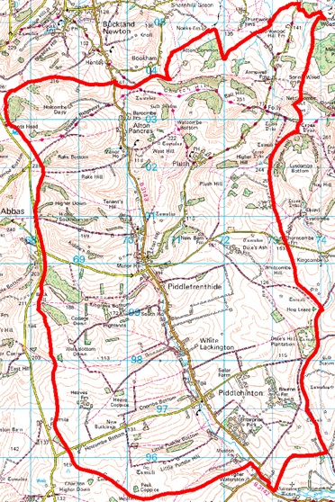
This Plan and its policies relate to the Piddle Valley neighbourhood area, which covers the three parishes of Piddlehinton, Piddletrenthide and Alton Pancras.
Piddle Valley Neighbourhood Plan – 2018 to 2033
© Crown Copyright and database right (2017). Ordnance Survey Licence number 100024307
This introduction tells the reader why and how the Plan was drafted, how long it will last and goes on to describe the Neighbourhood Plan area.
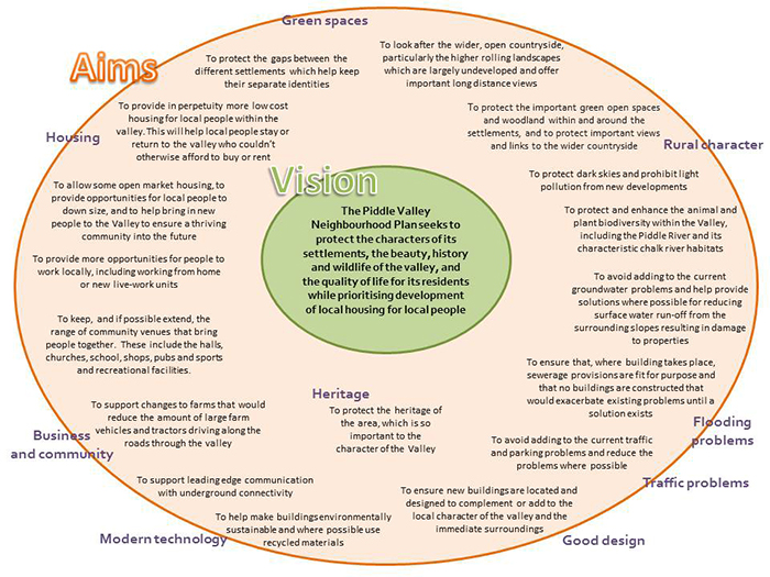
The next section sets out the main aims for the Plan. The following sections then set out the planning policies under these headings:
Maps and photographs are included alongside the text.
The Plan will last for 15 years from being made. However, if it becomes clear to the Parish Council that changes need to be made, or additional policies added to the Plan, the Parish Council will consider reviewing the Plan earlier than 2033. Any review will follow a similar process to the one for producing this Plan.
This section describes the Valley and what makes it different from other places. This is because the Plan will be used not only by local people, but also by developers who are submitting planning applications and by members of West Dorset District Council when considering planning applications.
Location
The Piddle Valley is a rural area in the heart of Dorset. It lies some 6 miles north of Dorchester and approximately 9 miles south of Sherborne. The main road through the Valley, the B3143, runs alongside the River Piddle through the settlements of Alton Pancras, southwards through Piddletrenthide, White Lackington and Piddlehinton. The small settlement of Plush lies to the northeast, on a tributary of the River Piddle.
Environment
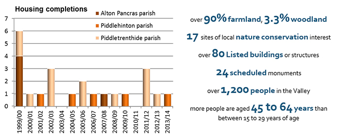
The area covered by the Neighbourhood Plan totals 4,450 hectares (11,000 acres). It is very rural in nature. Over 90% is farmland, 3.3% is woodland and the rest is built-up areas including the settlements and roads.
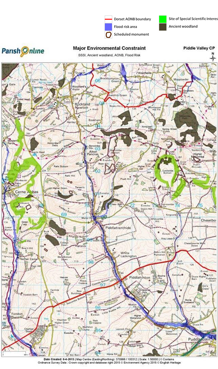
The landscape is dominated by open, chalk downland, with a linear settlement pattern along the valley floor. Most of the area is within the nationally important Dorset Area of Outstanding Natural Beauty (AONB) apart from a small section in the southern part of the Valley. There are magnificent views from the escarpment to the north east of Alton Pancras and Piddletrenthide which encompass the Blackmore Vale as far as the Mendips. From the chalk hilltops there are sweeping views across the chalk downs and into the valley itself, and south across the Purbecks. Views from the villages to the surrounding chalk downland are limited. The river valley has a different, more intimate and enclosed character, with old water meadows along the floodplain, small scale pastoral fields lined by dense and tree-rich hedgerows and characteristic settlements of stone, brick and flint.
There are no nationally important wildlife sites (Sites of Special Scientific Interest) within the valley. There are some just outside. To the west in Cerne Abbas parish are the Giant Hill and Blackdown Hill SSSIs, which form part of the Cerne and Sydling Downs European Special Area of Conservation – an area of calcareous (chalk) grassland which is home to the marsh fritillary butterfly. To the east in Cheselbourne and Melcombe Horsey parishes is the Lyscombe and Highdon SSSI, which is another area of chalk downland mixed with some scrub and ancient woodland. Within the Valley there are 17 sites of local nature conservation interest (SNCIs), mainly within or adjacent to woodland. Most of these sites are in fair to good condition but several have deteriorated due to lack of grazing livestock.
There are just over 80 Listed buildings or structures within the Valley, mainly in the settlements, with two Grade I churches (Church of All Saints in Church Lane, Piddletrenthide and Church of St Mary in Rectory Road, Piddlehinton), and three Grade II* Listings (The Manor House in Piddletrenthide, The Manor House in Alton Pancras and the Parish Church of St Pancras in Alton Pancras). The remainder are all Grade II.
There are 24 scheduled monuments, mainly historic field systems, earthworks and enclosures, barrows and tumuli. These are found primarily on the valley sides and higher ground. There is a medieval settlement (of Little Piddle) across the B3143 from Enterprise Park, and one just outside the area slightly further south.
Population
The 2011 Census shows there were 1,225 people living in the area. Compared to the South West average there is a notable lack of younger adults (with only 12% of the population aged between 15 to 29 years of age compared to 18% in the South West) and comparatively more people in late working age between 45 to 64 years old (36% compared to 27%). The other age ranges are broadly similar to the average seen across the South West.
The population is in generally good health, better than the national average (there are fewer people with long-term health problems or disabilities that limit their day-to-day activities).
People in the Valley relate very much to the settlement they live in first and foremost, rather than seeing themselves as part of single community that includes all the settlements in the Valley.
Housing and Businesses
Over the past 50 years the number of homes built in the Valley averaged between four and five a year, with particular boom periods in the immediate post war years and in the 1980s. The amount of new housing has been much lower in the 15 years from 2000 with only 23 new homes built in that time.
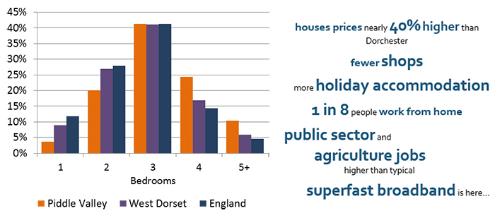
The average house price in the Valley for the last 5 years was £363,000 (based on 92 recorded sales), with properties in Plush and Piddletrenthide being more expensive than Piddlehinton or Alton Pancras. This compares to average house prices in Dorset and (more locally) Dorchester of around £260,000.
The 2011 Census shows 8.0% of homes had no permanent occupants (they were vacant or second homes). This varies between the three parishes, being notably higher in Piddletrenthide (10.2%, which includes Plush which has approx. 40%) and lower in Alton Pancras (1.4%). Just over 5% of households present at the time of the Census had another home elsewhere in the UK.
House sizes are also larger than average, with comparatively more four and five bedroom homes, and fewer one and two bedroom properties. The parish plan results suggest that a mix of small single (1 bedroom) properties, small family and larger family homes are needed.
Arguably housing supply has not kept up with demand in recent years, particularly for smaller and more affordable housing. The area is generally noted as having a high comparative degree of need compared to other rural parishes in West Dorset. In June 2015 there were 23 households on the District Council’s housing register with a local connection to the Valley requiring housing. This figure is likely to be a significant under-estimate of need, as about half of all households that were previously on the housing register did not re-register under the new system in early 2015, but may well do so when they realise they have been omitted.
Over the past 20 years there has been an overall decline in the number of shops and small businesses operating in the Valley. In contrast, the tourism and leisure industry has grown, reflected in the increasing number of bed and breakfast and second homes in the Valley. Enterprise Park provides the largest cluster of employment with some 41 employment units (when surveyed in late 2012) and businesses employing over 200 people.
The 2011 Census shows about 12% of workers work at or mainly from home (much higher than the national average and slightly higher than the district average). Of those in work, most people work in wholesale and retail trade, including motor repairs, education and social work. This is not dissimilar to the national picture. Public administration is also a main source of employment (Dorchester is a major centre for this type of work), and also agriculture and forestry (accounting for 10% of those in employment).
Broadband
Work has recently been completed to provide superfast broadband to properties in Piddlehinton and Piddlethrenthide, however work is still ongoing. It is noted that, despite ongoing work, properties in Alton Pancras may still be unlikely to receive fibre broadband service.
A contract has been signed which should bring superfast to Plush and the Enterprise Park during 2017-2018, however detailed timescales for this work are not yet available.
Traffic
The main north-south transport route along the Valley (the B3143) is used for school runs, farm vehicles, shopping trips and business deliveries. Some traffic uses Piddlehinton as a short cut to and from the A35 to access Charlton Down and beyond, producing a significant amount of through traffic. The lack of pavements, poor visibility at many of the access points, the winding and limited width of the roads (sometimes constrained further by on-street parking) and the relatively high number of vehicles that have been caught speeding, all give rise to understandable local concerns about road safety, even though at the time of writing this is not reflected in recorded accidents.
Although there are community facilities and work opportunities within walking distance of some people in the Valley, most households use personal transport to work and travel outside the Valley. A school bus system is effective in getting children to schools, but public transport is not always convenient and is infrequent.
Flooding
Due to its geology and topography parts of the Piddle Valley are prone to flooding on occasions. The flooding is a result of run-off from the upper slopes and high groundwater levels during prolonged wet periods. Although a flood alleviation scheme was constructed in 2004 that now protects over 50 homes from flooding in Piddletrenthide, there are still properties at risk. The flooding problems are also currently exacerbated by sewage contamination when groundwater levels are high enough to seep into the sewer through cracks and openings in the sewer pipe walls and manhole covers. However, sealing works are being carried out by Wessex Water to mitigate this ground water ingress.
Spaces and places protected from development
There are various features in the Piddle Valley that are special to local people. There are local green spaces and views that have real meaning or significance to most people which in the Local Plan may not have a specific ‘designation’. This Neighbourhood Plan identifies these spaces for protection, and recognises the importance of maintaining the open, undeveloped expanses of the chalk uplands and the gaps between the settlements. Some development that has taken place in these locations has detracted from the landscape. Other features, such as local wildlife areas and historic buildings, are generally well protected through the Local Plan policies, but this Plan highlights specific considerations relevant to this area.
Some community buildings or spaces are really important to the social cohesion of the settlements. The Piddle Valley works well as a community – people are rarely strangers as they meet in places like the school, the community halls, the village greens and recreation grounds or simply greeting each other on their way to and from their daily business. There are many activities going on where friends can be made. At least 30 clubs or groups run every year using the recreation grounds, pubs and village halls. Although some activities aren’t necessarily tied to a particular building or space (for example, post office services can run from shops or pubs, play equipment can be moved from one site to another), they do need a suitable venue to survive. If there isn’t a suitable venue in the local area where such activities can take place, then people will have to go much further afield or go without. This Plan lists those community facilities and current venues so that the impact of any change is fully considered when the long-term availability of such venues is threatened.
Local green spaces and views
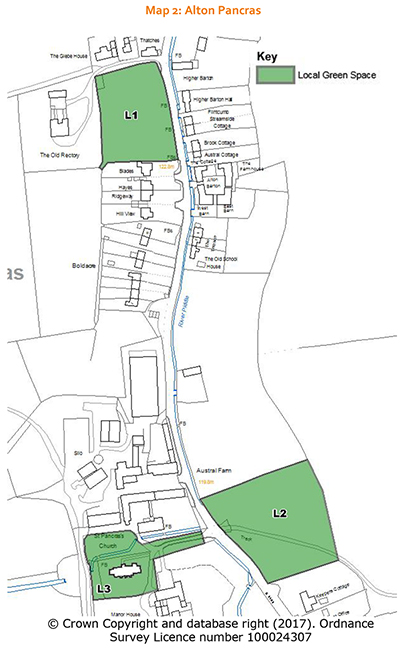
Within the Valley the variety of open spaces, both public and private, greatly enhance each settlement and contribute to their character. Some of these can be designated as local green spaces through the Neighbourhood Plan process. This designation gives a high degree of protection similar to green belts. It should only be used for spaces that are demonstrably special to the local community and hold a particular local significance. Each green space must be local in character and not extensive, and in reasonably close proximity to the community it serves. Their designation should last beyond the plan period but should not unduly limit future options for the settlement to grow. Thirteen such local green spaces have been identified in the Valley.
| Community Action: Significant Views. The Group Parish Council will seek opportunities to improve or create new views of the River Piddle and its tributaries from public rights of way where this does not detract from local landscape character. |
Policy1. Local green spaces
The following comprise areas of Local Green Space where development is ruled out other than in very special circumstances:
Views of the river, which is so important to the form and character of the Valley, are limited and could be improved.

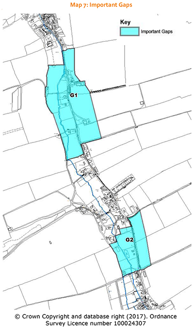
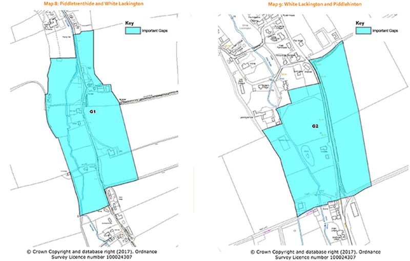
Gaps between settlements
The Valley is not one continuous settlement, but rather a number of distinct settlements, each of which has its own history and community spirit. It is important that the gaps of countryside between each community are not destroyed through gradual development, to the extent where they lose their undeveloped rural character and it is difficult to distinguish one community from another. The gap between the settlements which defines the main built-up parts of Piddlehinton and White Lackington is very short, as is the gap between White Lackington and Piddletrenthide. The Group Parish Council notes that the removal of existing, redundant structures in these gaps may help to strengthen the gaps, subject to how sites were treated following removal of the structures.
Policy 2. Important gaps between settlements
Development that would reduce the openness of the gaps separating the settlements of Piddlehinton, White Lackington and Piddletrenthide (as shown on the accompanying plans) will not be supported. Development which adds to the openness of these gaps, for example through the removal of redundant buildings and structures which do not contribute to local character or heritage, will be supported.
Features of local wildlife
The River Piddle is a natural chalk river which supports the most sensitive of aquatic communities and must be protected. The river rises at Alton Pancras and is augmented by springs. The River Piddle supports a diverse range of species: from large mammals and birds (such as otters, kingfishers and egrets) to smaller mammals (such as water voles), fish (including migratory eels) and invertebrates that feed the fish. The wildlife in this important habitat can be threatened by changes to the water quality (for example influences such as silt from highway and track runoff and nutrients from farming). The Dorset Wildlife Trust is working with some landowners to enhance biodiversity by improving the course of the river and bankside planting.
Woodlands are another important feature of both landscape and wildlife interest, and a project is outlined in a
later section that may help ensure that these valued areas are actively maintained in the long term.
The Group Parish Council will encourage the provision of a biodiversity appraisal to accompany planning applications, particularly where development proposals could help to bring about wider benefits to river or woodland habitats.
Policy 3. Improving wildlife areas
Development proposals should protect, and where appropriate enhance, the biodiversity of the countryside, the River Piddle and its tributaries. The provision of wildlife corridors and buffer areas to protect habitats, and the provision of new biodiversity features will be supported.
Important community facilities
As recently as 2011 the Valley’s village stores (and post office) was threatened with closure, but fortunately was saved by a local landowner. Its closure would be a very sad loss. Some community facilities have shut – for example the European Inn closed in February 2011 (although four pubs still remain in the Valley). The former church of St John the Baptist, at Plush, was declared redundant in 1988, but continues to be used as a concert venue. Community facilities rely on generating sufficient income from local people to sustain them.
Under the Community Right to Bid, the local community can nominate community buildings and facilities to be registered as an asset of community value. Once registered, the sale of a facility can be delayed to allow community groups to prepare a bid to buy and run that facility. Planning policies can work alongside this, by ensuring that a change of use is not permitted without due consideration. The fact that a community asset is listed as an asset of community value in itself can be a material planning consideration.
The list of community facilities includes those that the Parish Council would be minded to nominate under the Community Right to Bid, if they were likely to come under threat. These facilities will need to be able to adapt to remain fit for purpose for future generations, as needs and expectations change. For example, the Parish Plan has identified a need for better leisure facilities, especially for teenagers.
There may be circumstances during the lifetime of this plan when the community value placed on an asset has changed (for example, if a new facility has been provided in the interim, or the benefits of the proposed development is considered to outweigh its loss), and in such circumstances the Group Parish Council will seek to encourage the provision of evidence demonstrating the community’s support.
Policy 4. Important community facilities
The loss of the community facilities listed below will only be supported if, having involved the local community in assessing potential solutions to retain the facility, it is clear that their retention would be unreasonable on the grounds of viability, or it will be replaced by an equal or better community facility. Proposals will be supported that allow such facilities to be modernised and adapted for future needs.
The wider network of public footpaths and bridleways is also a valued community facility allowing both local residents and visitors to the area to enjoy access to the countryside, and providing an off-road link between the settlements. This network of routes is protected in the Local Plan, which makes sure that the routes are not severed or made less attractive overall as a result of new development. Other legislation exists that makes sure these rights of way remain open and well maintained.
Community Facilities The Parish Plan highlighted that there is an appetite for a large, modern community hall that could cater for larger events including sports and leisure uses (to complement and not necessarily replace the smaller village halls in each settlement). This would need to be taken forward as a project by the local community. A possible site at Piddletrenthide for such a facility has been identified in this plan, but its delivery will depend entirely on local community support for such a project, to develop the business case and raise the necessary funds (see Policy 9: Kingrove Farm, Piddletrenthide). |
There are places where development would be difficult to contemplate, because of existing problems such as flooding or traffic. These issues are often the first ones raised when people comment on planning applications and these policies are covered in more detail in this section. Other common concerns, such as the impact on neighbours’ living conditions (including noise, smells, privacy and daylight issues), are covered by the policies in the West Dorset District Council’s Local Plan.
Flooding and sewerage
The flooding and sewerage problems experienced in the Piddle Valley are a real concern for a significant number of residents and businesses. Development must not make this situation worse, and wherever possible, any potential to alleviate the current problems should be explored.
The National Planning Policy Framework sets strict tests to protect people and property from all forms of flood risk, whether this is from over-flowing rivers, directly from rainfall on the ground (surface water), rising groundwater, or overwhelmed sewers and drainage systems. It makes clear that we should not allow development (such as new homes) in areas at risk of flooding. It also considers the need to ensure development does not increase flood risk elsewhere, and talks about taking opportunities to reduce the causes and impacts of flooding where possible through new development.
The 2008 Strategic Flood Risk Assessment for West Dorset recognises that the Piddle Valley is exposed to a number of flood risks, and this is confirmed by the Wessex Water Inflow Management Plan of 2016/17. The main policy for the Piddle Valley area in the 2012 Frome and Piddle Catchment Flood Management Plan issued by the Environment Agency is to take action to store water or manage run-off in locations that provide overall flood risk reduction or environmental benefits. The Environment Agency wants to work closely with all their partners to improve the co-ordination of flood risk activities and agree the most effective way to manage flood risk in the future. Dorset County Council is the Lead Local Flood Authority, and as such is the statutory consultee for the consideration of surface water management, and responsible for investigating flooding events affecting people’s homes. Wessex Water is responsible for the public water and sewerage services in the area and have advised that all development proposals should provide separate systems of drainage with any agreed flood risk measures approved by the Lead Local Flood Authority for disposal to land drainage systems. Surface water connections to foul drainage will not be allowed.
Options to reduce flood risk continue to be investigated, for example Wessex Water have scheduled work to complete the sealing of all serious ingress points in the Valley sewers during 2015 -2016.
Policy 5. Reducing Flood Risk and Sewage Inundation
All proposals for new buildings connecting to the public sewerage system will need to demonstrate that they provide appropriate measures to prevent any groundwater inundation leading into the sewers from that development.
Until such time that a groundwater management strategy has been agreed for the Valley, the appropriate level of mitigation will need to be demonstrated through an independent drainage plan for that site prepared by a suitably qualified drainage expert.
Any flood risk assessment or drainage plan, where required, should clearly assess the opportunities to reduce the causes and impacts of flooding below current levels, including:
| Ideas on how to reduce flood risk have been discussed with the Environment Agency, Wessex Water and the County Council to try to find the best solution in the short and long term. Ideas to reduce flooding problems…
|
Traffic and road safety
Road safety was the main concern mentioned by two out of every three responses to the Parish Plan questionnaire in 2008. The 2013 School Travel Plan survey also found that many adults and children would prefer to walk or cycle to school but find this difficult due to the volume, speed and type of traffic that uses the local roads during peak times. Traffic surveys taken in Piddlehinton, Piddletrenthide and Alton Pancras in 2011 and 2013 back up these concerns, as they clearly show the extent of speeding and number of heavy vehicles on the Valley roads.
The Local Plan policy does not allow development that would have a significant detrimental effect on road safety. Some types of development can bring increased lorry or other large-scale traffic, which although not necessarily giving rise to road safety issues does detract from the rural character of the roads and lanes in this Area of Outstanding Natural Beauty.
Much of the means for managing existing traffic, such as speed control and determining the choice of traffic routes taken by large delivery lorries through the Valley, lies outside the control of the Neighbourhood Plan. However there are several projects that have been identified to address some of these concerns, as outlined in the box on the right.
The following policy attempts to ensure that the decision makers understand the strength of the concerns held.
Policy 6. Road safety concerns
New development must be safe and accessible, and where possible, contain clear and legible pedestrian routes. The enhancement of existing and provision of new safe walking and cycling connections will be supported.
On-street parking does cause congestion and potential hazards. In itself it can act as a speeding deterrent, but it adds to the road safety concerns where vehicles park dangerously or traffic continues to speed despite the limited visibility and narrowed nature of the road. The latter is generally the case in the Piddle Valley, and causes problems to pedestrians walking along or trying to cross the road. The Group Parish Council considers that sufficient parking provision should be provided on development sites in a manner that is convenient and will be used in preference to possible on-street parking, to avoid exacerbating these local problems further.
Traffic and road safety projects: Community Speed Watch initiative This project is already underway, but will need continued volunteer support if it is to remain successful. Alternative route for HGVs-the C12 (the top Sherborne Road) In the past the potential to upgrade the C12 to provide an alternative route has been looked into, but we know there are difficulties at the southern section and it therefore requires much more investigation and funding to achieve. If local people campaign for this route, then the County Council may look at this project again. |
The guidelines in the County Council’s 2011 residential car parking study set out the space requirements for new homes. For residential development, this equates broadly to 2 or more parking spaces per home. The guidelines state that parking spaces should be provided on hard standing, or in a car ports or car barns, or as garaging with an internal dimension of greater than 6m by 3m (each garage space is counted as providing the equivalent of half a space because of the evidence showing low use of garages for parking).
Locations for new development
The Neighbourhood Plan is about allowing acceptable development to take place. As part of the process of preparing this Plan, the working group considered and consulted the community on various sites to work out where development could take place. As a result of this consultation this Plan includes specific policies on two sites in Alton Pancras and Piddletrenthide.
The Local Plan provides a very clear approach to the control of development through the use of Defined Development Boundaries (DDBs). Within these DDBs residential, employment and other development will normally be permitted. Outside these boundaries opportunities for new homes, businesses or community buildings will be very limited.
Policy 7. Development outside the development boundaries
New homes will only be supported where a rural location is essential; or where the proposal would re-use redundant or disused buildings and lead to an enhancement to the immediate setting; or where the proposed dwelling is truly outstanding or innovative. The expansion of business and enterprise through the conversion and/or well designed new buildings and the diversification of agricultural and other land –based rural businesses will be supported, as will sustainable rural tourism that protects the character of the countryside.
| Community Land Trust Another project is to set up a Trust so that the affordable housing is managed for and by local people in perpetuity. This Trust could also manage other community assets as opportunities arise. |
Land Allocations
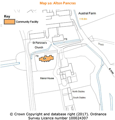
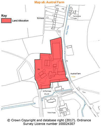
Land at Austral Farm, Alton Pancras
Summary: There is potential to provide a mix of housing and small artisan / craft-type business units in this central site within Alton Pancras. The scheme should retain and reuse the attractive historic farm buildings that are a key characteristic of the village.
The site relates closely to a cluster of important Listed buildings (the Manor House, St Pancras Church and Austral Farm House) within the Conservation Area. The older farm buildings were part of a model farm dating back to 1861. Although the older farm buildings themselves are not Listed they are of local character and worthy of retention (and the Conservation team at the District Council consider that they may warrant an application for Listing). There is considerable scope to respond to the unique character and interest of this site and the adjoining Listed buildings. The site lends itself to a mix of small ‘craft’ or home business workshops and housing units, incorporating a mix of affordable and open market homes. Large scale buildings (either in volume or of a height exceeding a modest two storeys) are unlikely to be acceptable. As well as the reuse of the characteristic farm buildings, the more modern structures on the northern part of the site could be replaced with more sensitive development, whilst maintaining and potentially strengthening the important undeveloped gap between the northern and southern parts of the village. The provision of some open market housing as part of a comprehensive scheme will help ensure that the standard of design is sufficient to enable a mixed use development to come forward in this sensitive location.
It is not anticipated that this site will have significant development – whatever comes forward needs to respect what is a very sensitive historic environment, and also any housing will not exceed what would be sufficient to meet local needs as a rural exception site.
Policy 8. Land at Austral Farm, Alton Pancras
The site shown on the accompanying plan is allocated as a mixed use site, to provide affordable and open market housing and small business units (either stand-alone B1 office / workshops or as part of flexible live-work units).
The proposals should be heritage led, with the primary objective to preserve and enhance the heritage assets and their settings, including securing the long term retention and appropriate re-use of the model farm buildings and features. Any new buildings should be sensitively located (taking into account the history of the site) and modest in scale (volume and height) to, and not detract from, these heritage assets. The removal of the more modern and unsympathetic additions, including the large cattle shed to the north, should be included within the comprehensive scheme for this site. The design and layout will also need to be informed by a full flood risk appraisal and incorporate suitable measures to reduce the risk of flooding downstream.
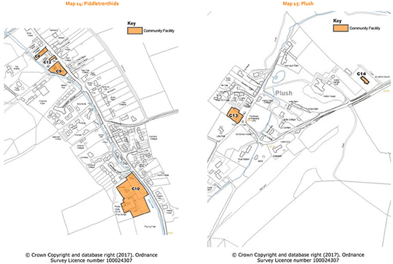
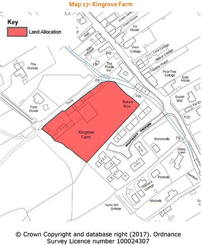
Land at Kingrove Farm, Piddletrenthide (rear of the Piddle Inn)
Summary: there is scope to build some new homes in this location to help provide affordable housing for local people. Some open market housing may be needed to help fund the new access and appropriate flood management measures. The farm buildings could be re-used (and the more modern buildings replaced) for employment or other community uses. The lower-lying land within the flood plain closer to the B3143 will remain undeveloped.
In 2005 the Inspector for the 2006 Local Plan concluded that land at Kingrove Farm was an appropriate location for new development, given that it was within easy walking distance of the village centre, and not particularly prominent in wider views.
The existing access to the site (off the bridleway from the road to Cerne Abbas) is not particularly suitable for additional vehicular traffic and has a rural character that should not be lost. A potential solution to provide vehicular access to the site would be via Wightman’s Orchard (which is in separate ownership and often full of parked cars). In this situation, the Group Parish Council recommends close working with local residents, the housing association and the land owners, to deliver an appropriate solution for off-road parking as close as possible to their homes, to reduce the problems associated with the high level of on-street parking that would otherwise be exacerbated by the new development.
By creating this access, the site’s wider potential is also unlocked. As well as affordable housing, the site has the potential to deliver a new, larger community hall with sports facilities and adequate parking. This may be an appropriate use for the large aisled C19 barn. Conditions would need to be applied to its hours of operation to ensure that nearby residents are not disturbed by late night noise.
The site is partly within the flood plain, and therefore any development will need to be guided by a detailed flood risk appraisal. Much of the site would remain open in character, and should continue to contribute to the open nature of the valley, its considerable visual interest and quality. Any new built development is likely to be limited to the south-eastern corner of the site on the rising land, clear of the flood risk area. Land closer to the river, could provide an opportunity for other purposes and be maintained for outdoor recreation and wildlife interest. Areas at risk of flooding should be retained as public open space or for communal use.
The layout and design of the site would need to consider any impact on the setting of the Listed buildings that are visible from the site (primarily along the main road). The height of the new development on the rising land will also need careful consideration to make sure it n’t unduly prominent, and the existing hedgerow boundary should be retained and strengthened with robust planting to create greater visual containment. The existing farm buildings - the large aisled C19 barn, the farm building on the south-west boundary and the other buildings attached to the barn on the north-east side are of local historic interest as undesignated heritage assets. The re-use of these historic farm buildings (and potential replacement of the more modern buildings), for workshop / studios or community uses (including a modern community hall), would provide a good mix of uses on this site, if done in a way that respects their heritage interest. A comprehensive, masterplanned approach is essential, particularly as the development of the site may need to be phased, and the retention and repair of the C19 barn and other significant buildings secured. Funding for the community facilities is likely to be reliant on fund-raising and should not delay the delivery of the affordable housing.
Policy 9. Kingrove Farm, Piddletrenthide
Land at Kingrove Farm is allocated for mixed use development where the provision of housing, including affordable housing, small-scale employment and community uses will be supported. Proposals must retain the historic barn, be informed by a flood risk assessment, include space for the provision of a community hall capable of providing for badminton and similar activities and take into account local character.
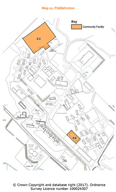
Large employment sites near Piddlehinton
Piddlehinton Camp, a large site south of Piddlehinton, was built during the Second World War to house troops in the preparations for D-Day. It is of historic interest as it is one of less than 25 of an original 1,100 camps surviving from the Second World War. Much of the area is now known as Enterprise Park. This is the main area of employment land in the Valley, primarily for start-up businesses, and is a key employment site in the Local Plan for West Dorset. The business park contains units used for light industry and office based businesses. The wider area also includes land used by the Royal School of Signals for training, the Puddletown Rugby Club, and a permanent gypsy settlement of 14 dwellings established in 1973. To the north-west lies Bourne Park, which was a farm that has become another employment site in this area.
There have been difficult choices in the past about whether retaining employment here is more important than the visual impact of the buildings and associated storage, particularly on the higher slopes that are clearly visible from surrounding areas. There are concerns about security, landscaping and general maintenance, and the impact of increased traffic, particularly the numbers of large lorries travelling along the Valley roads and the impact of traffic along London Row (which is narrow and steep-sided, with no pedestrian refuge). Due to the position of these employment areas outside the Dorset AONB, less emphasis has been placed on the landscape impact of proposals in this area. Although there is an existing landscape plan (dating back to the original planning consent in May 2000 that allows the reuse of the buildings), this may need to be updated particularly if development could have a notable impact on the wider landscape. The impact of security lighting and large-scale building on the upper slopes is clearly visible from some distance away and detracts from the AONB. The following policy provides clear guidance on the need to carefully balance the economic benefits of providing more modern employment buildings and facilities in this location, against the wider impact on the character of the Valley over time.
Policy 10. Enterprise Park
At Enterprise Park, small scale business development will be supported where it takes local character and the historic value of the Second World War camp into account.

Farming in the Piddle Valley
The area of farmland in the Piddle Valley totals 4,000 hectares (10,000 acres). The geology, which determines soil type is:
Upper Chalk in the south- this land is mainly level or with gentle slopes and as such is well suited to arable farming, particularly cereals and other combinable crops.
Upper Chalk to Middle and Lower Chalk with smaller areas of greensand and clay in the north - a high proportion of moderate to steep slopes better suited to grassland and livestock farming.
Recent developments in building design and new materials together with discrete siting offer the prospect of greatly reduced impact on the landscape. The Group Parish Council would like to see new buildings situated adjacent to existing buildings, with the emphasis given to landscape protection and the avoidance of development on higher landscapes, as this can detract from long distance views. \
| Agricultural permitted development rights: Permitted development rights mean that, if a farm is 5 hectares or more in size, the farmer generally has the right to erect, extend or alter an agricultural building provided that
In certain cases, including the erection of new buildings or where significant changes are proposed, details of the buildings' design, materials and siting may need to be submitted for approval, so that the planning authority can consider the effect of the development upon the landscape, heritage and wildlife interests. They also need to have regard to the operational needs of agricultural businesses and the need to avoid imposing any unnecessary or excessively costly requirements on the farmer. More limited rights, including extensions and alterations adding not more than 10% to the content of the original building, are available to smaller farms (those between 0.4 and 5 hectares in size). Although permitted development rights introduced in 2014 allow the conversion of redundant farm buildings to housing (subject to specific criteria), these do not apply to Areas of Outstanding Natural Beauty, which covers much of this area. |
Redundant farm buildings outside a development boundary
The potential for redundant farm buildings to be converted to other uses is another possible source of new housing and home-work units. In principle, the re-use of attractive rural buildings (such as old stone barns) that are genuinely redundant should be encouraged..
The reuse of redundant farm buildings for uses other than farming or forestry-related operations is not considered appropriate for buildings of no architectural merit. Examples of buildings that do not make a positive contribution to the local character can be those made of concrete block, steel-framed buildings and buildings with large corrugated roofs. The re-use of redundant farm buildings for community or business is covered by policies in the Local Plan for West Dorset.
Where the building is a designated heritage asset, a pragmatic approach may need to be taken to secure its long term future, in line with the Local Plan policies.
It should be noted that this policy does not remove any permitted development rights, and therefore can only be applied where planning consent is needed.
| Community Action: The Group Parish Council will seek to promote the removal of redundant buildings of no historic or architectural merit, when opportunities to do so arise. |
Policy 11. Re-use of redundant farm buildings as dwellings
The residential re-use of a redundant agricultural building outside a development boundary that makes a positive contribution to the local character will be supported, provided that all of the following criteria are met:
Understanding the character of the main settlements in the Valley
The settlements of the Piddle Valley are different in character.
Alton Pancras
This linear village nestles on the valley floor of the River Piddle, which rises here and flows southwards through the Valley. Its housing is based on two early farm settlements, Barcombe to the north, Austral to the south, with an area of green open countryside dividing the two, most notable on its east side. It still retains the feel of a farming, working community, with the attractive 19th century brick and flint farm buildings forming part of the street scene.
There is a range of building styles spanning four centuries, from thatch to redbrick. A small 1990 development of 10 houses at the northern approach compares with a row of traditional-style thatched cottages from the south, some being modern replicas of their neighbouring originals. The middle of the village has a mix of housing styles. A row of three whitewashed dwellings with thatched roofs is aptly named The Terrace, while opposite is a row of eight substantial houses with large gardens built by Dorchester Rural District Council in 1956. To the north, four bungalows built in the 1960s, replaced four dilapidated thatched cottages.
Heading south, the church and the Manor House are next to each other on the west side of the B3143. Both are in spacious grounds, and are not prominent to passing traffic as they are set back from the road and partly screened by mature trees. These two buildings are important in the history and character of the settlement.
The road leading south leaves the village past one of the original thatched cottages and with open, undulating hills on both sides, heads for Piddletrenthide, past the former Domesday mill, now converted into two dwellings.
Development in the village should be of an interesting mix of individual or small groups relating to the main road, rather than residential estates. The future of the farm buildings, if they become redundant, provides an obvious opportunity for the village to grow. The gaps and green open spaces linking to the river should be retained as these provide important breathing spaces on the west side.
Plush
Plush is a rural hamlet of about 30 houses situated a mile and a half northeast of Piddletrenthide at the base of a steep sided valley on a narrow unclassified road. A tributary of the River Piddle flows through the hamlet and into the river at Piddletrenthide.
Entering the village from the south the distinctive early mediaeval lynchets can be seen which hint at the settlement’s ancient origins. Also on the south side of the hamlet lies Plush cricket ground, with its attractive pavilion. Spectators here have a fine view of the surrounding countryside
The settlement itself is largely hidden within a fold of the hills amongst areas of woodland and fine mature beech trees. The core of the hamlet is a central green space on the sharp bend where the famous hostelry, the Brace of Pheasants, welcomes the visitor. The pub overlooks this green, while the Plush Stream circles its far side before running down the valley to join the River Piddle. The dominant property is Plush Manor, set in spacious grounds below Plush Hill. The former church is home to the Plush Music Festival, which is held over several weekends throughout the summer and attracts visitors from far and wide.
Over half of the houses are listed as of historical or architectural interest. They are informally arranged along the rural lanes that twist through the settlement. The houses have large gardens and these together with the village green give the hamlet an open and loose-knit environment. Buildings are constructed of brick, brick and flint or rendered walls with roofs mainly of thatch or slate with a few tiled roofs. More recent development on the site of a former orchid nursery fully reflects the materials used in the older houses. They are attractively designed and sit easily with the more established houses in the hamlet. .
Until relatively recently the hamlet was surrounded by three dairy farms. These have now been absorbed by neighbouring farms to form viable units for the future. The attractive redundant farm buildings at Harveys Farm, directly adjacent to the hamlet, would benefit from a new use appropriate to their historic character, to ensure they are kept in a good state of repair.
Future development should be sensitive to the rural nature of the hamlet and reflect the materials used in existing buildings, the generally loose-knit character, and the notable presence of mature trees and hedges.
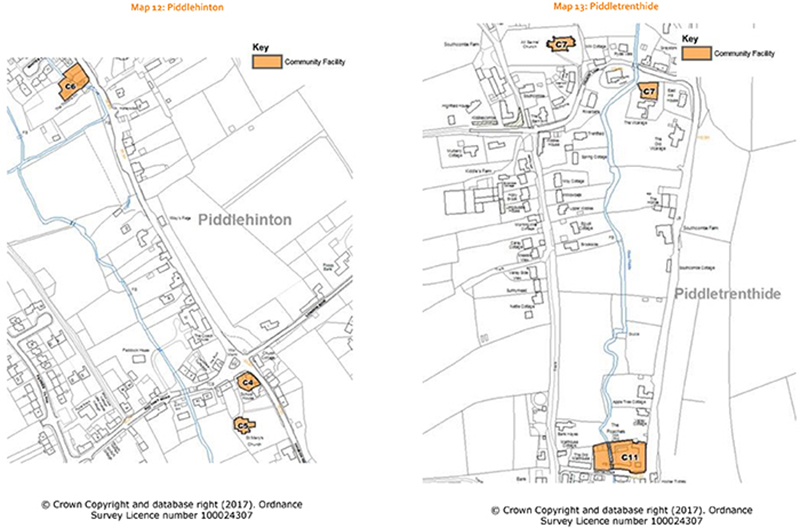
Piddletrenthide
Piddletrenthide is a long linear settlement divided into smaller clusters by open undeveloped areas that offer views of the river Piddle and the surrounding countryside. Retaining these open spaces can preserve the character of the village and avoid continuous ribbon development through the valley.
The northern cluster marks the core of the old village around the beautiful All Saints church with its fine west tower. Church Lane leads from the valley road across the river to Egypt where there are several newer houses. There is a mix of styles of housing with both old and new but mostly with large gardens and an open feel.
Low density frontage development on the western side of the main road leads south to the junction with Smiths Lane where the Poachers Inn is situated. There are some older cottages running west from the valley road. The Manor House with its grounds forms a break in the development and there is a fine view opposite the house to the east. The former grounds are a locally important garden listed by the Dorset Gardens Trust.
The main part of the village has a higher density of development and consists of a mixture of older cottages (two dating back to the sixteenth century) 18th and 19th century housing, the former school and late 20th century cul de sac developments on either side of the road. The Post Office and the Piddle Inn are in this cluster and both are valuable assets to community life. There is a variety of building materials including brick and flint, cob and predominately rendering with tiled, slated and thatched roofs.
The modern first school is set back from the road and access is across the river via two arched bridges. There is a small children’s play area and the football field which gives an open aspect to this part of the village.
The Piddletrenthide and Piddlehinton Conservation Area Appraisal produced by West Dorset District Council provides additional supporting information on the special interests of this specific area.
White Lackington
The settlement of White Lackington developed at the crossroads of an important east/west drove road and the valley road and is centred on the former Fleet Farm.
The settlement here contains a mixture of older housing, Lackington Mill, former farmhouses, the now converted 19th century European Inn and a number of more recently built houses. The line of former local authority housing, South View, stretches east from the main road up a shallow combe. Development to the north and south has reduced the open space between the different settlements.
Piddlehinton
Piddlehinton is a long established settlement, which developed as a bridging point over the Piddle River. The main crossroads junction still forms the centre of the village. Close to the crossroads stands the War Memorial, together with a water pump and a commemorative tree.
The valley road north of the crossroads is known as High Street and contains a number of larger properties including the Thimble Inn, and a small modern cul-de-sac, White’s Close, on the western side. The undeveloped open spaces along this road are important to the character of the village. London Row heads eastwards away from the crossroads up the chalk slopes; it is a characteristic narrow and high sided lane and these features should be maintained and not diminished. Higher up the slopes another modern cul-de-sac, London Close, branches off London Row and provides a range of affordable and owner occupied houses. Discretely positioned at the far end of London Row, renewable energy developments (comprising biodigester and photovoltaic systems), make Piddlehinton a net producer of electricity.
To the west of the crossroads, Rectory Road has a mixture of older cottages with more modern infill and the Old Rectory. This, with the beginnings of Church Hill to the south of the crossroads, forms the Conservation area, containing 10 listed buildings including St Mary’s Church, with 13th century origins, and the Village Hall (unlisted). At the western end of the village a modern development, Payne’s Close, extends northwards in a cul-de-sac. Alongside the Piddle River and to the south-west of the Thimble Inn, the Millennium Green forms a valuable recreational and natural open space. A bridleway, West Lane, extends from Rectory Road, alongside the Millennium Green, through White Lackington to Piddletrenthide, linking the settlements.
The River Piddle meanders through the village and although there is no longer a working mill there are egrets, herons, kingfishers, ducks, and the occasional otter on the water meadows, with buzzards soaring above. Sluice gates for flooding the meadows are still to be found at various points along the river. The agricultural use of the sloping hillsides around the village is mainly arable, but also includes beef cattle, sheep and two pig farms, plus grazing for horses.
The Piddletrenthide and Piddlehinton Conservation Area Appraisal produced by West Dorset District Council provides additional supporting information on the special interests of this specific area.
Detailed design and building materials through the Valley
Chalk and clay have been used for some buildings to make cob for cottage and boundary walls, with flint and brick used for more significant buildings. Field stone was locally quarried for laying coursed or random rubble walls for larger houses while dressed stone, often banded with flint, as at Whites Dairy House in Piddlehinton, has been used for the Parish Churches and surrounding cottages in Piddletrenthide and Piddlehinton. Mixtures of different materials have added a richness of variety, most commonly flint banded with red brick and ashlar or facing stone with brick and render. Examples are the former Village School and Pear Tree Cottage and Middle Thatch in Piddletrenthide.
Bricks were produced here from the early 18th century and were still locally available from Broadmayne until the 20th century. They can be recognised from their buff to red colour with carbon spots on the surface. From the early 19th century brick was often considered of inferior appearance and lime-washed or even rendered and incised with course lines to represent stone blocks. Unusual old purple brickwork with red dressings may be seen at Alton Pancras Manor House contrasted with yellow ashlar stonework.
The use of lime in building was universal until the early 20th century when production of cement (which is duller in appearance) became common. Lime lets materials breathe by absorbing and evaporating rainwater and allows movement without cracking in the heat and cold of the changing seasons.
Structural timber framing is not common but green oak is often used for beams, lintels over openings and for external cladding.
In terms of roofing, Purbeck stone slates may still be seen at eaves and for wall cappings but the traditional straw thatch is evident everywhere, sometimes replaced in modern times with water reed. Thatch is relatively expensive with outer layers needing to be renewed every 25 years or so. Slate from Wales and Cornwall became common with the introduction of the railways in the 19th century. Clay tiles were used less commonly and cheaper, concrete versions were adopted during the 1960s and 70s. The latter has not blended in successfully with the local materials. Plain clay tiles and double pantiles can be seen in Piddlehinton. Other natural materials such as lead and zinc are also found in the Valley.
Sustainable designs
The government is driving improvements to the energy efficiency of new buildings through changes to Building Regulations (rather than having different standards in different parts of the country).
Flexibility in designs is also a key consideration, to enable a building to readily adapt to the needs of its future occupiers as changes can be very costly if not considered in the initial design. Basic requirements are being delivered through changes to Building Regulations at a national level.
This drive for more sustainable designs ultimately make homes and businesses more affordable to run, and this Neighbourhood Plan encourages developers to go beyond the building regulations requirements.
| Sustainable design projects that could be taken forward by local people Domestic Heating / Energy Reduction Project: establish a resource to advise on domestic energy saving based on reducing the energy required (e.g. by improving insulation), reducing energy consumption (e.g. by replacing inefficient heat sources) and by adopting renewable or low carbon energy sources Solar Panels Project: produce guidance for residents and businesses on how to site solar panels on domestic and business properties so that they are discrete and sympathetic to their surroundings. Hydropower Project: set up a River Piddle hydropower scheme to generate power for the Piddle Valley VE CA First School, in liaison with the Environment Agency. Woodland Fuel + Bi-products Project: establish a co-operative scheme for existing woodland users (landowners / pheasant / game shoots) to manage currently unmanaged woodlands through a 7-10 year management cycle, allowing individual ownerships to remain in place, supporting local full time employment generation with reintroduction of coppicing and new planting for longer term sustainability, enabling fallen timber to be utilised for wood fuel with logs and bi-products available for purchase in the Valley and reuse of redundant storage facilities for products and equipment. |
Policy 12. The character and design of new development
Development, including extensions and porches, should have regard to the character of the surrounding area to which it relates, in terms of the plot size, density, scale and massing, tree cover and landscaping (including boundary treatments). It should not significantly change the character, for example through over-intensive development.
The design of development should be sympathetic to the form, style and colour of nearby existing traditional buildings. It should respect but not necessarily copy the style of existing buildings. Imaginative designs are encouraged and proposals should demonstrate the use of locally appropriate materials that weather well.
Traditional building materials such as stone, flint, brick, slate, timber and lime mortar and render are appropriate. The use of modern materials may also be appropriate because of their character (in relation to contemporary building designs) and sustainability credentials.
The ability to adapt housing to allow people to work from home is important. Where possible, ducting (that can accept fibre optic cabling or its future equivalent) should be provided to the public highway or other suitable point of connection.
External lighting
Lighting is often added to a building or area for security or recreational purposes. Although these are obvious benefits, such lighting diminishes the enjoyment of our ‘dark skies’ that are a valued feature of the Valley.
The cumulative impact of additional lighting schemes is a concern. Where external lighting is proposed, applicants will be expected to justify why it is necessary and how it minimises potential light pollution from glare and spillage. This approach also applies to the consideration of street lighting and lighting in parking courtyards, and such lighting should not be made a highways requirement.
| When does lighting require planning consent? Not all lighting proposals require planning consent, as the lighting itself does not constitute development, and the installation of light fittings does not in general alter a building's appearance to any significant extent. However, planning conditions can be included to prevent such a change without permission. If the building is a Listed building, Listed building approval is always required. |
Policy 13. External lighting
Where planning permission is required for external lighting and the lighting will impact on local landscape character, proposals should seek to demonstrate that the benefits of the external lighting proposed should outweigh any harm arising.
| Settlement | Location | Character | Purpose |
| Alton Pancras | Land east of The Old Rectory | Open green space in the heart of the village | Important green space adding to the character of the settlement. |
| Area below the Millennium Seat | Open downland with bridleway. Due to its rising topography and tree-scape it offers fine views. | Protect views up to and from the Millennium Seat | |
| Area around St Pancras Church | Open grass verges on approach to church and the land surrounding the church forms the graveyard. | Protect setting of the historic church - St Pancras Church, a Grade 2* Listed Church | |
| Piddle-hinton | Millennium Green and adjoining fields | Ancient water meadows with the River Piddle running through it. Includes children’s play facilities, benches, picnic tables, BBQ’s, and educational material about the local wild life. The fields adjoining the Green are of an open character allowing the countryside to penetrate into the heart of the village and up to the B3143. | The open character allows the countryside to penetrate into the heart of the village and up to the B3143, and make a significant contribution to the rural character of the village. In addition, the Millennium Green is managed by the Millennium Green Trust and is used for many local activities and events. |
| Land around the war memorial | A small green triangle where the road from the west joins the B3143, forms an important site for the War Memorial and old village pump | Protect setting of the war memorial and focal point of this part of the village | |
| Land around St Mary’s Church | Open field providing an attractive approach to the church and graveyard | Protect setting of the historic church – Grade I Listed | |
| Piddle-trenthide | Land around All Saints Church | Green Space containing the approach to the church and graveyard | Protect setting of the historic church – Grade I Listed |
| Green area off Church Lane | Green open space surrounding the Rectory and includes parking spaces for church visitors. Provides fine views of the church and surrounding properties from the B3143 | Protect setting of bridge and cottages, and views of the church | |
| Land opposite the Manor House | Historic parkland lying in the base of a valley, surrounded by trees including a large number of fine beeches. The open aspect provides fine views from the B3143. | Protect view up the valley and historically important parkland setting to Manor House (which carries on up the valley and forms part of a Locally Listed Park and also contains a Listed Gazebo and a Listed Dovecote close to the northern boundary | |
| Football Field | Grass playing field, | Used for recreation as the home ground of Piddletrenthide Football Team, an important recreational facility for the Piddle Valley Primary School as well as being used by the wider community for a range of events | |
| Plush | Land around former Church of St John the Baptist | Churchyard – although the church became redundant in 1987 (and is now used as the location for Music at Plush as a concert venue) the churchyard continues to be used as a graveyard | Protect setting of the historic church – Grade II Listed |
| ‘Jock’s Paddock’ opposite the Brace of Pheasants | Open green space in the heart of the village surrounded by a number of traditional Listed Buildings | Used for many local events – subject to a covenant that the field must form a community green and remain undeveloped except for the possible provision of a small pavilion. | |
| Cricket ground | Grassed area with trees, laid out for use as cricket pitch | Cricket pitch and pavilion used by local residents and visiting teams, and also used for local events |