
The Appendices provide additional background and statistical information to the Local Plan. Where relevant, they will be taken into account in the determination of planning applications.
(see plan on page 8)
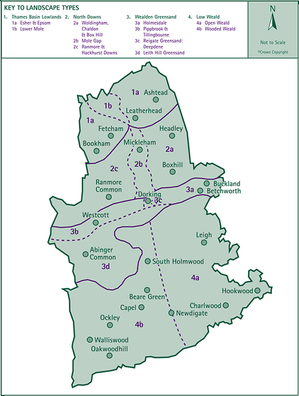
'The Future of Surrey's Landscape and Woodlands'* identifies seven regional countryside character areas in Surrey and within these, twenty five county landscape character areas. In Mole Valley, four of the regional countryside character areas are represented with eleven county landscape character areas. These are:
| Regional Countryside Character Areas |
County Landscape Character Areas |
| Thames Basin Lowlands |
• Esher & Epsom • Lower Mole |
| North Downs |
• Woldingham, Chaldon & Box Hill • Mole Gap • Ranmore & Hackhurst Downs |
| Wealden Greensand |
• Holmesdale • Pippbrook & Tillingbourne • Reigate Greensand: Deepdene • Leith Hill Greensand |
| Low Weald |
• Open Weald • Wooded Weald |
Using this classification, the District's landscape has been analysed and a profile of each character area has been prepared.
The profiles will be used in assessing whether development proposals satisfy the Plan's policies that seek to conserve and enhance the richness and diversity of the District's landscape, particularly the Surrey Hills Area of Outstanding Natural Beauty and the Area of Great Landscape Value.
The area consists predominantly of farmland with small woodlands and the River Mole, which meanders through a broad valley northwards to the Thames. The open, flat valley floor is bounded by gently sloping sides and is set within a gently undulating landscape.
The area between Bookham and Ashtead, excluding the valley of the River Mole, lies within this landscape character area. Much of the area is built-up but there are tracts of open undulating countryside and extensive wooded areas including Bookham Common and Ashtead Common. The gentle dip slope of the North Downs to the south of Bookham and Ashtead provides a broad undulating farming landscape composed of a patchwork of fields and occasional irregular blocks of woodland. Although close to the built-up areas, this area retains much of its rural agricultural landscape character. It provides a transition between the densely wooded landscape on top of the North Downs and the built-up areas.
Red bricks and red tiles.
Hedgerows, especially on boundaries between builtup area and countryside.
Timber post and rail fences and brick walls.
North of Leatherhead the River Mole flows through a broad gentle valley. The river rises in flood here to form lakes which transform the landscape. The valley is rather open with occasional small blocks of woodland and some strips of riparian woodland. The land is mostly used for farming and has a strong hedgerow pattern. There are also some areas of horsiculture.
There are several small-scale landscapes of surprising quality and value. Areas to the north of Leatherhead, including the Common Meadow and Fetcham Splash which form part of the flood plain of the River Mole, provide access to intimate river landscapes.
The M25 runs across the valley and is a major feature in the landscape.
Red bricks and red tiles.
Hedgerows, especially on boundaries between builtup areas and countryside.
Timber post and rail fences and brick walls.
The North Downs is a prominent landscape feature visible over wide areas of Surrey. Much of the scarp is wooded especially the top parts where the woodland on the dip slope extends over the top of the Downs and onto the scarp. The lower slopes are more open but are being colonised by scrub. Where the downland is open, species rich grassland exists.
Within the North Downs there are three distinct landscape character areas in Mole Valley: Woldingham, Chaldon and Box Hill; Mole Gap and Ranmore and Hackhurst Downs.
Along this stretch of the Downs, to the east of the Mole Gap, the dip slope is dissected by a series of steep U-shaped valleys. Between the valleys, and at the top of the dip slope, are areas of flat open plateau. Where valleys join, the intervening high ground narrows to form the characteristic blunt profile of the Downs. There is a special sense of openness on top of the Downs despite the encroachment of scrub and woodland.
Despite the simplicity of the underlying chalk geology, there is a great variety of surface deposits of sands, gravels and clay with flint, each with their own characteristic vegetation. There are the acidic heathland areas such as Headley Heath, ash and field maple woodlands on clay soils and oak and birch woodland on the flinty clay soils. Yew and box are characteristic of the steep exposed chalk slopes while belts of woodland on the open downland contain either beech or ash and field maple. Hedgerows are not generally characteristic of the downland, but in places the remnants of an old hedge line remain.
Chalk quarries, such as at Betchworth are prominent landmarks and give the scarp a dramatic aspect.
Boxhill and Headley are the two villages in this area. In Headley especially, local flint has been used in traditional building construction. Brick has been also often used for corners and door and window surrounds. The rich orange-reds of Wealden bricks contrast attractively with the cool grey of the flintwork.
• Red brick and tiles, occasionally decorative or running in patterns, grey slate and white-painted walls.
• Hedgerows, tree belts, shrubs and brick walls.
• New development should be sited within the landscape on the sides of slopes, avoiding the top of the North Downs.
This is a striking corridor of landscape between Dorking and Leatherhead where the River Mole cuts through the chalk escarpment to create a spectacular geomorphological feature.
The valley is flanked on the east by the precipitous, wooded slopes of Box Hill and by more gently rising farmland, vineyards and parkland on the west, including Norbury Park. This is included on the English Heritage Parks and Gardens Register and was originally laid out in the late eighteenth century to provide a picturesque setting to Norbury Park House.
Semi-natural woodland on the steep sides of the valley is a very important element in the landscape. Although much of it has been substantially storm damaged there is good natural regeneration.
The Mole Gap is also an important transport corridor for road and rail. The A24 follows the line of the River Mole and provides important views of the distinctive outline of Box Hill.
Mickleham is the only village in this area. It has a linear form and flanks the Old London Road with an outlying group of properties at Byttom Hill overlooking Norbury Park. It is mostly 18th and 19th century in character.
Red brick, flint and tile predominate with render and slate also to be seen.
Red and brown brick, flint, red-tiled roofs, vertical tile hanging to upper floors and white-painted walls.
Open boundaries, hedges, hedgerow trees, banks, shrubs and brick walls.
This area includes the downland to the west of the River Mole. It is densely wooded. Fields tend to be in small clearings surrounded by woodland or separated by thick shaws. The area has a remote character. The landscape of the dip slope to the north of the area is more open. Around Polesden Lacey parkland merges into farmland among rolling hills and valleys with belts of woodland and shaws following the contours of the land. Lanes flanked by hedges wind their way across this landscape and paths thread through it.
This area contains the full range of woodland types found on the Downs including native yew and beech woods, beech plantations and some ash and field maple coppice. There are also extensive tracts of forestry containing conifers and broadleaved species. Most of the woodland is recent but there are pockets of ancient woodland especially on the scarp of the Downs.
Ranmore Common is an extensive and diverse woodland covering a series of hills and valleys. The woods are dominated by tall beeches with holly and yew understorey. At the top of the dip slope there are often areas of rough grassland. In contrast, at Denbies, there are parkland trees, mainly limes and sweet chestnuts.
On the scarp slope, areas of open grassland provide a valuable contrast to the secondary woodland and offer views over the Greensand ridge and Weald to the south.
There are no villages in this area, only a few scattered farms and isolated groups of houses. Local flint, brick and tile give a mellow appearance to buildings in the area.
• Red brick, stone, flint and red tiles, white render and natural timber.
• Stone and flint boundary walls and belts of trees along boundaries.
The Wealden Greensand runs parallel to and south of the North Downs. It is typified by a south facing scarp, and a dip slope running north down to the base of the scarp of the North Downs. It is a complex landscape character region, which primarily can be divided into the Greensand Hills, and the Greensand Valley lying between the Greensand Hills and the North Downs.
In Mole Valley, the Greensand Valley is lined by a string of villages each with its own distinctive character. Isolated farm houses and their associated buildings are also characteristic of this area. The A25 and the North Downs railway line running east-west are significant features of the landscape. The landscape of the countryside is characterised by green pastureland and hedged fields. There is a range of woodland types reflecting the diversity of soil types.
The District's Greensand Valley is subdivided into three character areas: Holmesdale, Pippbrook and Tillingbourne and a small isolated area of Reigate Greensand at Deepdene. The Leith Hill Greensand character area represents the District's Greensand Hills.
The A25 corridor between Reigate and Dorking is overshadowed on the north side by the North Downs. They provide a dramatic contrast to the flatter, more open parkland and farmland of the Holmesdale Corridor.
East of Dorking the agricultural landscape is small-scale, with an intricate patchwork of fields, woodland belts, hedgerows and copses. There are no significant areas of woodland in this area but lines of single oak trees marking old hedge lines are an important feature in the landscape. Around Betchworth and Buckland there are numerous field trees - mainly oaks but also some sycamore and beech. There are extensive parkland landscapes around Betchworth containing specimen trees.
Mineral workings and the A25 are significant features in the landscape of the Holmesdale Corridor. The road takes a meandering course which respects the local topography and opens up different vistas and perspectives.
The picturesque villages of Buckland, Betchworth and Brockham have historic cores which retain close links with the surrounding landscape. A parkland landscape is a characteristic feature of the Betchworth area. A range of building materials have been used in those villages, but principally red/orange bricks and tiles and white painted render.
Red/orange and buff bricks, white-painted render, red roof and hanging tiles and natural timber weatherboarding.
Brick walls and low hedges on boundaries.
This is a small-scale landscape of mixed agricultural areas interspersed with woodland. Fields are separated by thick, low hedges but others have been amalgamated especially at the foot of the Downs. Winding lanes, hedges and rolling landform give the area a sense of enclosure. In particular in the area west of Dorking the sense of being in a valley is, in places, very strong, with the distinctive scarp slope of the Downs to the north and the steeply rising wooded slopes of the Greensand Hills to the south. The valley between Westcott and Abinger Hammer, which contains the Pipp Brook and the Tilling Bourne, broadens out and forms a strip of good farming land which includes extensive areas of woodland on the North Downs scarp slope.
The character of the area is influenced by major landowners including Wotton Estates and the National Trust. The landscaped park at Wotton House has contributed to the character of the valley. Outside the villages of Westcott and Abinger Hammer, there are isolated dwellings and farm buildings and the dramatically situated St John's Church, Wotton. These buildings are important features in the landscape.
Local stone walls are a feature along the highway and elsewhere low, thick, well maintained hedgerows are important features.
Abinger Hammer lies at the west end of the valley overlooking the green and the Tilling Bourne. It has a strong 19th century flavour to its character. The watercress beds to the east of the village are a significant feature. The predominant materials are brick and tile with some local stone and weatherboarding. Chimneys are a notable feature. Many properties in the village are part of the Wotton Estate. The use of yellow and blue paintwork by the Estate is a feature of the area.
• Red brick and flint; red roof and hanging tiles to upper floors. Natural timber also appropriate.
• Boundaries around new buildings should be low, thick hedges, post and rail fences or red brick walls.
The Reigate Greensand is a narrow band of low, sandy hills running westwards from the Kent border, decreasing in height to Dorking. A small, detached area lies immediately to the east of Dorking at Deepdene.
This part of the Greensand lies between Betchworth, where the ridge is barely visible, and Dorking, where it forms the eastern and southern slopes of the town. On the outskirts of Dorking is Betchworth Park, with Betchworth Castle on a knoll, but little remains of the original picturesque landscape. Deepdene itself, with its famous amphitheatre garden, a long valley terraced and planted, now partially restored. The A24 carves its way up the Greensand ridge through Dorking, sunken and surrounded by long belts of mature trees, an interesting landscape feature in its own right.
Red brick and stone walls, red-tiled roofs and tile hanging, white render and exposed timber.
Brick and stone walls, hedges, timber post and rail fences and park railings.
The ridge of Greensand is a dominant feature running west-east from Holmbury St Mary to Dorking. The area is characterised by large areas of rugged, wooded hills. It is relatively unspoilt and has a quality of remoteness which is unusual in Surrey. A characteristic feature of the soft, easily eroded sandstone of the Greensand is the deeply cut tracks and roads, some as much as 10 metres below the surrounding land level. The Leith Hill Greensand ridge provides a dramatic backdrop to the low-lying Weald in the south and provides extensive views north and south. East of Dorking it becomes barely visible and is reduced to a narrow band of low hill.
The scarp slope of the ridge and the upper part of the dip slope are heavily wooded and contain a scattering of houses whose gardens merge with the woodland. In contrast, much of the lower dip slope is open and rolling and is farmed.
The Greensand ridge is characterised by light sandy, acid and well drained soils which support mainly conifer trees although there are areas of alkaline-loving woodland. The wooded areas have extensive plantations of scots and corsican pine, norway spruce, western hemlock and larch with a few beech plantations. Often conifer blocks are edged with broadleaf woodland or scrub. Most of the woodlands are actively managed for timber.
The heathland, which formerly covered most of the area, only remains in small parts. Generally now, it has been invaded by scrub, especially conifers and birch, to form secondary woodland.
There are several man-made water features that are of historic and landscape interest which blend with and enhanced the surrounding countryside.
The Greensand Hills are divided by a series of deep interlocking valleys containing villages including Friday Street, Holmbury St Mary, Abinger Common and Coldharbour which have something of the character of upland villages. They have a much valued quality of isolation and remoteness by virtue of their small size and compact nature and the dense woodland that hems them in.
An important element of village form in this area is the open spaces which underlines the organic development of each settlement and the visual relationship with its rural surroundings. Many of the buildings are of modest character and size. The use of local stone, brick and tile gives a distinctive, mellow appearance to buildings.
Red brick and red tiles on roofs and tile hanging to upper floors.
White render and exposed timber.
Hedges, grass banks and tree belts along boundaries.
The Weald has a more open and gently undulating topography than other areas of Mole Valley. It is a small-scale landscape composed of an intricate mix of small woodlands, a patchwork of fields, and hedgerows. A localised limestone outcrop produces a distinctive ridge at Norwood Hill.
The area contains many attractive landscape features and wildlife habitats including roadside ponds, meandering streams with bankside vegetation and steep-sided gills. The irregular shaped woodlands, tree belts and shaws are remnants of a once extensive area of woodland cover. Oak is characteristic of the Weald but the woodland, much of which is ancient and semi-natural, is rich in tree, shrub and ground flora. Hedgerows too, are generally species rich and a significant landscape feature. Narrow winding roads and lanes follow the sinuous lines of hedgerows throughout the Weald and provide varied views towards the more dramatic scenery of the Greensand ridge and North Downs escarpment.
Within the Low Weald in Mole Valley there are two distinct landscape character areas.
The landscape to the east of Newdigate is generally more open and agricultural than the wooded Weald to the west. Woodlands are generally small discrete blocks of less than 10ha. Around Leigh and Charlwood, broad lines of oak trees alongside hedgerows are a characteristic feature.
The Weald to the west of Newdigate becomes progressively more wooded. Woods tend to be sinuous and winding in shape extending out in long shaws among steep sided stream valleys or gills which are typical of this area. Fields characteristically appear as clearings in the midst of large areas of woodland. Wide grass verges with mature oaks are an important feature around Oakwoodhill.
Many of the villages in the Weald are designated Conservation Areas which retain a close relationship with the surrounding landscape. They have still kept their intimate scale. Some retain the atmosphere, in both name and layout of woodland clearings, such as Forest Green and Oakwoodhill. In many Wealden villages the relationship with the landscape is reinforced by fields which punctuate built-up frontages and allow views outward into neighbouring countryside. Their small-scale village greens, key buildings, notably the parish church, and the use of traditional building materials and detailing create the valuable heritage of the Wealden village.
The relatively high density of small, scattered farmsteads is a characteristic feature in the landscape of the Low Weald.
Traditionally, buildings in the Weald have been constructed using locally available materials: oak was used on medieval buildings and locally produced brick, stone and tile on later buildings. Horsham stone is a characteristic roofing material on vernacular buildings in the area.
(1) Open Weald
Red brick and tiles, contrasting white-painted walls or weatherboards with exposed black beams and occasionally slate.
Low, square cut hedges with hedgerow oaks, tree belts or brick walls.
(2) Wooded Weald
Red brick and roof tiles, white weatherboarding and contrasting exposed black beams.
Hedges or tree belts for new boundaries. Occasionally white timber palisade fences for more open boundaries around residential areas.
* The Future of Surrey's Landscape and Woodlands - Part 1: Landscape Assessment. Published by Surrey County Council.
< Previous | ^ Top | Next >