
2.1 The District of Mole Valley lies at the heart of Surrey, mid-way between London and the Sussex coast. It covers an area of 258 square kilometres (about a hundred square miles) and has a resident population of approximately 80,000 people.
2.2 The majority of Mole Valley's population (72%) live in the main built-up areas which comprise 7% of the District's area. They include the District's two main towns of Dorking (population 16,000 including the adjoining settlement of North Holmwood) and Leatherhead (population 9,700) and the predominantly residential areas of Ashtead (population 13,500), Bookham (population 10,300) and Fetcham (population 8,400), which have grown up around original village centres.

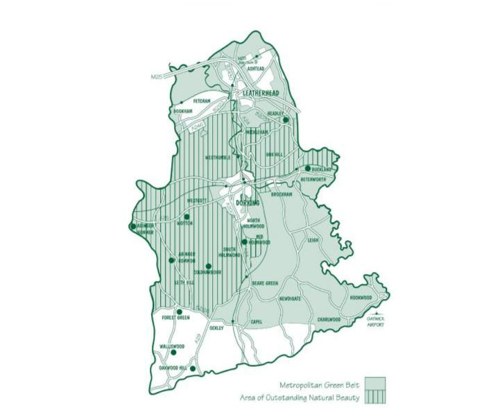
2.3 Mole Valley's countryside is extensive, accounting for over 90% of the District's area. It contains a variety of attractive villages (all with a population of less than 3,000 people), hamlets and scattered isolated dwellings and farms.
2.4 The landscape of the District's countryside is also highly attractive. The chalk hills of the North Downs run east to west across Mole Valley. This includes well known beauty spots such as Box Hill. To the south of the Downs the District's countryside forms part of the gently undulating and open Low Weald landscape, while the Greensand ridge, including Leith Hill, the highest point in the South East, crosses the south west of the District.
2.5 The River Mole meanders north through the District from its source in Sussex and provides an attractive setting to Leatherhead and Dorking as well as the more dramatic cutting through the North Downs known as the Mole Gap.
2.6 Three main roads run through Mole Valley. The M25 has a junction at Leatherhead, the A24 London to Worthing road runs from north to south and the A25 which follows the foot of the North Downs from Maidstone in Kent to Guildford, runs from east to west. Two main railway lines, occupying the same corridors as the A24 and A25, provide rail services to London and Horsham, Reading, Redhill and Gatwick airport. There is also a service between London Waterloo and Guildford via Bookham.
2.7 Gatwick Airport in the adjoining West Sussex Borough of Crawley, abuts Mole Valley's south eastern boundary and therefore provides the District's residents and businesses with excellent access, but noise from aircraft affects villages in the southern part of the District, particularly Charlwood, Newdigate and Capel.
2.8 The following sections expand on the profile of the District and some of the key issues. This is followed by a series of goals that have been identified following consultation, that the Core Strategy seeks to deliver through the Vision, spatial objectives and policies.
2.9 The 2001 Census population figure for Mole Valley is 80,300 persons in some 31,860 households. Most of the District's population (54%) is aged 25-64, but a significant proportion (19%) is over 65 and 23% is under 18.
2.10 Mole Valley's population is forecast to increase by between 3,100 and 8,200 people over the period to 2026. The lower figure is based on the predicted level of new housing while the higher is the 2006 based Office of National Statistics (ONS) population projection figure. It is also forecast to become increasingly elderly, particularly as the population is generally healthy and long-lived. This has implications for the provision of housing, employment opportunities and services.
2.11 A significantly higher proportion of Mole Valley's population is in the higher socio-economic groups and has higher professional qualifications than the national average.
2.12 As a whole, Mole Valley is a relatively affluent area. The 2007 Indices of Multiple Deprivation indicate that Mole Valley is the 339th least deprived local authority area in the UK out of a total of 354 local authorities. The District is the 4th least deprived in Surrey. However, when measured against the indices there are parts of the District, including and in particular North Holmwood and a part of North Leatherhead, which experience relative levels of deprivation in comparison to other parts of Surrey.
2.13 There is a high level of car ownership in Mole Valley but 13% of households do not own a car. In the rural wards the proportion of households without a car ranges from 6.1% (Okewood ward) to 14.3% (Beare Green and Holmwoods wards). In the areas of North Leatherhead and Dorking, levels of households without a car rises to 20%. In areas of the District including parts of the built-up areas, it is not easy to access public transport and other services without a car and isolation can be an issue for many residents.
2.14 A very low proportion of Mole Valley's population identifies themselves as from the Black and Minority Ethnic groups, only 2.6% compared to the England average of 10% (Census 2001). As part of its work on equality and 'hard to reach' or 'seldom heard' groups, the Council has identified a small number of such communities in the District.
2.15 The goals set out in the following sections and the subsequent spatial objectives all aim to ensure that the causes of inequality across the District are reduced.
2.16 Mole Valley is covered by a number of planning policy and strategic environmental designations.
2.17 Three quarters of the District is within the Metropolitan Green Belt surrounding London. The boundary of the Green Belt was established in the Local Plans of the 1980's. The main built-up areas of the District do not form part of the Green Belt but are 'inset' from it. The larger villages of Westcott, Brockham, Capel, Charlwood and Beare Green (set out in Policy CS1 ' Where Development will be Directed' ) (A Spatial Strategy) are also 'inset' from the Green Belt.
2.18 Much of Mole Valley's attractive landscape is of nationally recognised importance, with just over a third of the District forming part of the Surrey Hills Area of Outstanding Natural Beauty (AONB).
2.19 Within the District there are also considerable areas of major ecological importance. There are twelve Sites of Special Scientific Importance (SSSI's) wholly or partly within Mole Valley, covering almost 9% of the District's area. These include Ashtead Common which is a National Nature Reserve (NNR), Leith Hill, Ranmore Common and the Mole Gap to Reigate Escarpment which is also designated as a European Special Area of Conservation (SAC).
2.20 To the north west of the District lies another ecological site of European importance, the Thames Basin Heaths Special Protection Area (SPA). The Wisley and Ockham Commons SSSIs forming part of the SPA, lie within 5kms of part of the built-up area of Bookham.
2.21 There are 52 sites covering 855 hectares which are designated as Sites of Nature Conservation Importance (SNCIs). There are also a number of Regionally Important Geological / Geomorphological Sites (RIGGS).
2.22 Mole Valley's built heritage is also extensive. There are 28 Conservation Areas wholly or partly within the district and 1,000 Listed Buildings, a higher number in comparison with the average for the Surrey districts and boroughs.
2.23 There are 27 Scheduled Ancient Monuments in Mole Valley and five gardens on the register of Parks and Gardens of Special Historic Interest compiled by English Heritage. The National Trust is one of the largest land owners in the District.
Goal 1 To safeguard and enhance the highly attractive and diverse natural, built and historic environment of the District. |
2.24 Although Mole Valley's population has only increased by 1.4% since 1991, there has been a 6.7% increase in the number of dwellings. Nearly all the additional dwellings were constructed in the built-up areas of the District.
2.25 The continuous provision of more housing in the built-up areas through the redevelopment of small sites is impacting on the character of parts of the established residential areas. The pressures of intensification through additional development, traffic and other activity are increasingly felt, not just in terms of major development schemes, but also the collective and cumulative effects of small scale developments.
2.26 Moreover, the cumulative effect of additional development is having an impact on infrastructure and service requirements. There is public concern about the availability and quality of infrastructure and that the full range of infrastructure, services and community facilities has not kept pace with increasing housing development.
2.27 The trend towards smaller households has been reflected in the type and size of properties constructed in Mole Valley. For example, in 2006/07, 82% of all new homes had one or two bedrooms and 11% had three bedrooms. Many of these were flats and apartments. However, although the average household size in Mole Valley is now 2.35 people, with 29% of households comprising one person and a further 37% comprising two people, around 70% of existing homes in Mole Valley have three or more bedrooms.
2.28 Within the District there are some communities which have a number of households living in mobile home parks (788 households; 2.28% of the total population). The 2001 Census identified that the majority of these households where residing in the wards of Boxhill and Headley (516 households; 48.7% of the total population of Boxhill and Headley); and Beare Green (138 households; 15.5% of the total population of Beare Green).
2.29 Over the period to 2026, the Council has to make provision for at least 3,760 new dwellings in Mole Valley in accordance with the South East Plan.
2.30 There are many households in Mole Valley who because of the present relationship between house prices and incomes are unable to meet their housing needs in the District's housing market. The high cost of housing in Mole Valley is driving many local residents out of the District to less expensive areas. This includes many essential workers whose employment is of particular importance to the local community. The strength of the housing market also means many younger people have to live with their parents when they would prefer to live independently. The Mole Valley Housing Needs Study (2007) forecasts a net annual shortfall of 1,070 affordable homes and identifies the need to increase the provision of affordable housing.
2.31 It is also necessary to address the particular housing needs of specific groups in the community for example Gypsies and Travellers, and the ageing population. The Council jointly commissioned with its East Surrey local authority partners a Gypsy and Traveller Accommodation Assessment (GTAA) which was used to provide advice to the South East England Partnership Board (SEEPB) who have responsibility to set the level of new pitch provision in each District and Borough in the Region. Consultation on the proposed distribution of pitches across the South East by SEEPB shows it is likely that 6/7 new pitches for Gypsies and Travellers will be required within the District by 2016. The Council is currently in the process of bringing forward three new pitches which will count towards meeting the total requirement.
2.32 The particular housing needs of the ageing population will also need to be considered.
Goal 2 To ensure provision of sufficient land to meet the District's housing requirements and provide a range of homes to address needs and means |
2.33 Mole Valley is an economically prosperous district benefiting from its location close to the economic generators of London, two international airports Gatwick and Heathrow, and access to the national motorway network via the M25 at Leatherhead. Partly due to this, Mole Valley traditionally has been an area of high market demand and subject to intense pressure for development. There are approximately 5,000 firms in Mole Valley employing around 46,000 people. The service sector provides the majority of the employment opportunities with a number of national and international companies having their headquarters in the District.
2.34 The total stock of commercial (offices, factories and warehouses) floorspace in Mole Valley was 496,000 square metres of which 269,000 square metres was business floorspace at April 2007. At March 2008 approximately 7% of the office stock was vacant and there was planning permission for 42,900 square metres of business floorspace. This will enable some economic growth to take place in the District without the need for further land. Furthermore, modern flexible working practises may help contribute to the achievement of sustainable economic growth without significant increases in employment floorspace.
2.35 However, there is pressure to redevelop some employment land in the District for housing. This could prejudice the sustainable growth of the District's economy. On the other hand, significant growth in employment floorspace could result in local labour shortages, increased in-commuting and pressure on infrastructure and the wider environment of the District.
2.36 Unemployment rates are historically amongst the lowest regionally and nationally. As a consequence, local businesses often find it hard to recruit employees, especially for lower paid jobs and in some areas there is a disparity between jobs available and the skills of residents.
2.37 The rural areas of the District also contribute to the local economy. Agriculture remains an important part of the rural economy but continues to undergo change. This has generated pressure for the diversification of farm holdings. Many agricultural and rural buildings have been converted and now provide accommodation for a variety of businesses providing a wide range of services. Mineral extraction is also a feature of the rural economy. There are two operational brickworks at South Holmwood and Capel and a mothballed facility at Okewoodhill. Sand extraction takes place in the Buckland / Betchworth area. There are also waste treatment and recycling operations at Betchworth and Capel and on the rural fringes of Dorking and Leatherhead.
2.38 The countryside also accommodates a variety of other businesses that contribute to the District's economy. These include the headquarters of major firms, institutions, hotels and conference facilities.
2.39 Tourism and visitor related facilities also make a significant contribution to the rural economy. The District's countryside with its high quality landscape, extensive public access and regionally significant visitor attractions is a popular destination from nearby urban areas and beyond.
Goal 3 To maintain a successful, sustainable and diverse local economy. |
2.40 Surrey has the highest level of car ownership and the most congested roads in the country outside London. Nearly half of Mole Valley's households own two or more cars compared to the national average of 29.5%. Of all the District's households, 13% do not own a car compared to the national average of 27%. Those areas with the lowest level of car ownership include Dorking and North Leatherhead. Around two out of three Mole Valley residents travel to work by car.
2.41 Approximately 40,000 people travel into and out of Mole Valley to work every day. About two thirds of these journeys are made by car which is less than the national average but still a significant amount of car traffic. In addition, many journeys are made by people crossing the District to other employment centres and major traffic generators including Heathrow and Gatwick Airports. These journeys, as well as journeys to schools, create significant peak hour congestion, especially around the built-up areas of Dorking and Leatherhead. This results in poor accessibility to the District's town centres, a deterioration of the local environment, considerable frustration to residents and visitors and contributes to the causes of climate change.
2.42 Around 10% of Mole Valley residents travel to work by train compared to 7.4% nationally, reflecting the generally good access to London by train. However, a lower proportion travel to work by bus, only 1.1% against a national average of 7.5%. This reflects the fact that bus services are poor in most places, especially in the evenings and particularly in the rural areas. However, demand responsive bus services are being developed to improve day time accessibility, particularly in the rural areas of the District.
2.43 Gatwick Airport abuts the District's south eastern boundary. It has an impact on the District through disturbance from aircraft noise on the ground and in the air; increased traffic on the rural road network of the south east of the District; and, the gradual expansion of the airport's activities on the land to the north side of the airport where it abuts Mole Valley. The northern part of the District is overflown by aircraft from Heathrow which sometimes causes disturbance to communities in this part of the District.
2.44 The Government indicated in the 2003 Aviation White Paper - The Future of Air Transport - that it does not intend to take action to overturn the 1979 Legal Agreement which prevents the construction of a second runway at Gatwick Airport before 2019. However, it proposes to keep open the option of a second runway at Gatwick after 2019. In the meantime, BAA Gatwick has prepared an Interim Master Plan for the airport setting out the development necessary to facilitate the airport's growth from its current through-put of 35 million passengers per annum to 40 million passengers. It also identifies land to be safeguarded in the event of the provision of a second runway. The Council accepts the airport's growth within its single runway two terminal configuration, subject to environmental safeguards being in place, but is opposed to the development of a second runway.
Goal 4 To manage down traffic growth and encourage more sustainable transport choices by improving travel options and accessibility. |
2.45 The shopping centres in Leatherhead and Dorking are an important part of their overall character. Both centres are relatively small scale in Surrey terms and mainly serve their local communities and surrounding villages. Dorking is the larger of the two town centres with just over 200 shops and a further 110 premises provide restaurants, financial and related services. In total these uses amount to 23,000 square metres. Leatherhead has approximately 150 shops and other retail premises which in total amount to approximately 20,700 square metres of floorspace.
2.46 Both towns face strong competition from nearby larger centres, including Epsom, Kingston, Guildford, Horsham and Crawley which offer a more extensive range and choice of retail and other town centre facilities. Changing trends in retailing mean that they also have to compete increasingly with mail order and internet shopping. However, the town centres support other social, community, cultural and recreational facilities along with certain shops not normally present in out-of-town locations and they are generally more accessible by public transport. There has been pressure to change shop units to restaurants and cafés.
2.47 The study into the District's town, local, district and village centres which was commissioned by the Council recommended that the forecast increase in available expenditure by people currently using the District's centres would support an increase in comparison and convenience goods floorspace over the next ten years with the increase in convenience floorspace focused on Ashtead and Dorking. The study also forecast there is likely to be additional available expenditure to support more leisure facilities in the town centres.
2.48 The local shopping centres at Ashtead, Fetcham and Bookham are important focal points for their local communities providing easy access to a range of shops and services. There is evidence from the study commissioned by the Council that a high proportion of residents in Ashtead travel outside of the village for their convenience shopping requirements. The study recommended that the addition of a new food store in Ashtead could have the potential to 'claw back' trade to the village and reduce the distance local residents have to travel for convenience shopping. The study also showed that around 70% of residents in Bookham and Fetcham carry out their main food shopping trips in stores in Leatherhead, notwithstanding the two small existing supermarkets in Bookham.
2.49 There are also a number of smaller shopping parades in the built-up areas and villages serving rural communities, although in recent years a number of these shops and post offices have closed due to the difficulty of remaining viable in the face of changing shopping patterns.
Goal 5 To ensure the District's town, district, local and village centres are successful and viable places for people to live, shop and spend their leisure time. |
2.50 It is important that communities, particularly children, young people and the elderly have access to open space close to where they live. Open spaces in the District's built-up areas make a significant contribution to the character and amenity of those areas, which contributes to the quality of life of local communities.
2.51 In terms of the amount of open space, sports and recreation facilities available to local communities, the picture across the District is felt to be one of reasonable or good provision and there is an extensive network of public rights of way. However, there are some localised deficiencies potentially felt most acutely in the more urban areas. In many cases deficits are to some extent compensated for by large areas of natural and semi-natural green space nearby. Communities across the District consider their facilities are important and should be retained.
2.52 In terms of built recreation facilities, Mole Valley is served by the Dorking Sports Centre and the Leatherhead Leisure Centre. These are public facilities with swimming pools. There are also a number of private health and fitness clubs and a range of more local halls and pavilions.
2.53 Improving facilities and support for young people is a priority of the Community Strategy. This includes the provision of more outdoor facilities such as skate parks and youth shelters as well as indoor facilities such as youth cafes and youth centres.
2.54 In terms of cultural facilities, there are local museums and libraries in Leatherhead and Dorking. There are also libraries at Ashtead, Bookham and a performing arts library at the Denbies Winery near Dorking and a range of arts facilities in the Leatherhead Theatre and the Dorking Halls. There are also many activities offered from village and neighbourhood halls.
2.55 There is increasing demand to use the attractive countryside for recreation from residents and visitors alike. Around the towns and villages there is pressure to use land for horse grazing with a demand for related buildings and structures. There is some demand for informal country pursuits and more formal outdoor sporting activities, which may present some opportunities for farm diversification.
Goal 6 To safeguard and ensure provision of sufficient land and facilities for open space, sport and recreation to meet current and future requirements. |
2.56 The Government expects local authorities to play an important part in reducing emissions that contribute to climate change and reducing the consumption of natural resources to limit climate change. For example, the impact of new development on climate change can be reduced by locating it in places where it is not entirely necessary to rely on having access to a car, by the design of carbon neutral homes and helping to achieve energy and water efficiency through sustainable construction, and increased use of renewable energy.
2.57 Local authorities also have a role to play in addressing the effects of climate change, through for example minimising flood risk to people and property.
2.58 Evidence has indicated that Mole Valley residents have a relatively significant ecological footprint on the planet. The footprint is calculated by measuring a range of indicators including the emissions from homes and the level of fuel emissions from the use of vehicles. The Ecological Footprint of the UK (at 2007) is 5.4 global hectares per person compared with a world average of 2.2 global hectares. The South East has the highest per capita Ecological Footprint in England with 6.1 global hectares, while Mole Valley's footprint is 6.39 global hectares which is the third largest in England.
Goal 7 To use natural resources wisely, reduce emissions that contribute to climate change and minimise the risk to communities from the effects of climate change. |
2.59 One of the main concerns about accommodating new development, particularly the building of new homes, is that the provision of infrastructure, services and community facilities should be related to the scale and pace of growth. This includes the provision of public transport, education and health facilities, water, sewage and power supplies, waste treatment and recycling facilities, social services, emergency services and other facilities including those for open space and recreation.
2.60 Because most new housing in Mole Valley is built on small sites within the existing built-up areas, it is difficult to phase development and make sure the provision of infrastructure and services is in line with the rate of building. There are concerns about the ability of the existing infrastructure to cope with these gradual but collectively significant increases in demand. There are also concerns about where the necessary investment will come from if the agencies involved do not build adequate resources and safeguards into their investment programmes to allow them to accelerate provision when this becomes necessary.
2.61 The South East Plan indicates that the scale and pace of development will depend on sufficient capacity being available in existing infrastructure to meet the needs of new development. Where this cannot be demonstrated, the scale and pace of development will be dependent on additional capacity being released through demand management measures or better management of existing infrastructure, or through the provision of new infrastructure. Where new development creates a need for additional infrastructure, a programme of delivery should be agreed before development begins. The Government expects local authorities to pursue a 'Manage and Invest' strategy towards infrastructure provision.
Goal 8 To ensure the efficient use of existing infrastructure, a reduction in demand on infrastructure by promoting behavioural change and ensuring the delivery of additional capacity by extending or providing new infrastructure. |
2.62 Overall, the picture of Mole Valley is one of high intrinsic environmental quality but where the pressures of development, traffic and other activity is being felt increasingly.
2.63 Over time planning controls have prevented the outward spread of the District's built-up areas and the accommodation of development requirements has resulted in more intensive development, particularly in the north of the District. The pressures of development, traffic and other activity are being felt increasingly, not just in terms of major development schemes but also as the result of the collective and cumulative effects of small scale developments.
2.64 The key planning issues in Mole Valley centre on making provision for new development to meet the requirements set out in the regional spatial strategy and to meet local needs while protecting the environmental characteristics and feel of the District.
< Previous | ^ Top | Next >