

© Crown Copyright and database rights [2015]. OS [100021328]. Use of this data is subject to terms and conditions.
Figure 63: Focus Area 7 – Central St Leonards & Bohemia
6.185 Extending from White Rock gardens in the east to Grand Parade in the west, and inland to the Bohemia Road shopping area, this is the most densely populated part of the Borough, with approximately 85 people per hectare and almost 9,500 residents. It is also the second most economically deprived (ONS) with almost 20% of the working age population claiming Job Seekers Allowance (Department of Work and Pensions – Nomis statistics).
6.186 In spite of the high population density, there are some significant open spaces, notably Warrior Square with its formal seaside planting, White Rock Gardens, and Gensing Gardens. St Leonards Warrior Square railway station is here too, at the heart of the shopping centre. Housing here is mostly terraced and Victorian, with many Houses in Multiple Occupation (HMO). The employers here are predominantly shops and public sector employers, such as the Revenues & Customs and Social Services offices at Ocean House.
6.187 After the waning of its Victorian heydays, Central St Leonards & Bohemia have begun to change. Around St Leonards Town Centre and the seafront, significant regeneration has taken place. Many derelict properties along the seafront have been refurbished, and a new health centre has been built on the site of the long-derelict Marlborough Hotel. More recently, new 'boutique' hotels have opened, nationally promoted as fashionable places to stay. Around St Leonards centre, some of the narrow streets adjacent to Mercatoria, in the Gensing Farm area, have seen an up-lift, with owners refurbishing previously run-down properties. And the shopping centre itself is changing fast, with an influx of new cafés, restaurants and shops signalling significant new investment in many of the shopping streets.
6.188 This is also an ethnically diverse part of Town, with many different nationalities represented. This has led to the opening of many niche shops, cafés and restaurants to meet the needs of these particular parts of the community, and these attract visitors to the area. This trend is contributing to the positive regeneration of the Focus Area.
6.189 The regeneration of this area has begun, but it is only a start. We need to encourage new businesses to the area, retail in particular. However, tourist accommodation in the shape of more 'boutique' hotels particularly along the seafront is important. Other businesses in the creative sector would especially fit in well with the mix and atmosphere of this area. So we will do all we can to encourage small businesses, and work with them to promote and establish themselves. We expect St Leonards centre to become a focus for independent and niche shops, cafés and restaurants, something that serves the local community as well as being a tourist attraction. This is something that we will investigate through the potential for a cultural quarter in this area promoting joint working between the Local Authority, business owners and the local community.
6.190 Policy FA2 of the Planning Strategy indicates a range of 240-300 new homes to be planned for Central St Leonards & Bohemia up to 2028. This is an inner urban area where flats and small terraced houses can provide low-priced starter homes for younger residents. We will expect these to be of innovative design, creating good quality homes, with a mix of ownership, rented and affordable housing.
6.191 The seafront will also continue to improve, becoming more of a tourist destination and connecting with St Leonards centre. As well as using enforcement powers to get property owners to improve their buildings, we will investigate and encourage, where appropriate, quality conversions of properties to visitor accommodation, particularly along the seafront. To retain the character of the seafront we will be encouraging restoration rather than replacement of properties, at least externally. The Council-owned seafront structures, especially 'Bottle Alley' will also need major refurbishment. We anticipate that changes here will mean the creation of catering and retail spaces on the seafront, and will do all we can to encourage local businesses to take up these opportunities.
6.192 To the north of the area around the Bohemia shopping centre, the decline of the retail centre needs to be managed. We will investigate the possibilities here, including retail, catering, workshops, live/work units, or even conversions back into residential properties.
| Site reference | Address | Allocation (including potential number of homes) | Area (ha) | Does the site have a brief in section 5? |
| CLB1 | 1-3 Chapel Park Road | Residential (27) | 0.13 | ✖ |
| CLB2 | Taxi Office/B.R. Social Club, St Johns Road | Mixed use (30) | 0.12 | ✔ |
| CLB3 | Sorting Office site, Kings Road | Mixed use (9) | 0.05 | ✖ |
| CLB4 | 4-5 Stockleigh Road | Residential (12) | 0.03 | ✖ |
Table 9: Residential, mixed use and other allocations for Central St Leonards & Bohemia
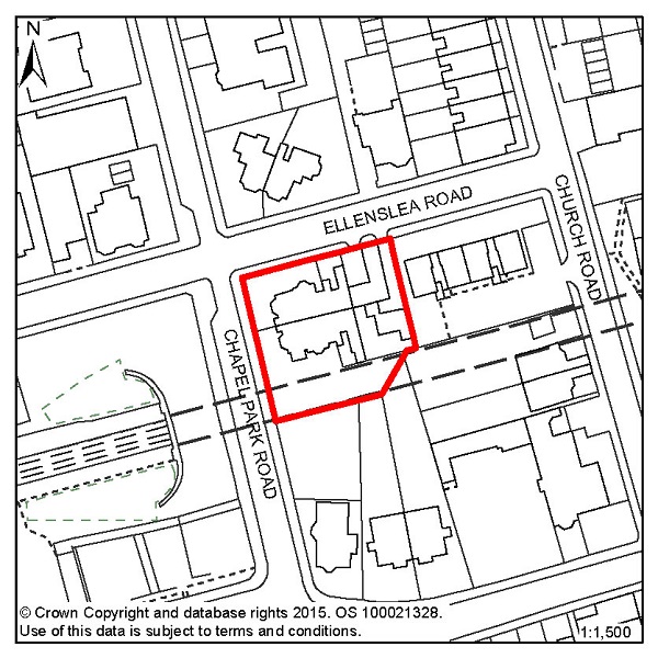
Figure 64: CLB1 – 1-3 Chapel Park Road
Site address: 1-3 Chapel Park Road
Allocated use: Residential
Area: 0.13ha
Possible net capacity: 27
6.193 Site CLB1 – 1-3 Chapel Park Road is a prominent corner site that sits above Warrior Square Station alongside the entrance to the eastbound tunnel, currently occupied by a pair of semi-detached villas.
6.194 CLB1 is sited immediately adjacent to the Kings Road Conservation Area. Proposals for this site will therefore need to take account of the likely impact on the Kings Road Conservation Area. This site will be expected to support a varied housing mix, including affordable housing. The capacity potential of this site indicates that a Transport Report will be required. Further advice on transport matters is available from East Sussex County Council.
Policy CLB1 - 1-3 Chapel Park Road
1-3 Chapel Park Road is allocated for residential development (possible net capacity 27 dwellings).
Development proposals for this site will:
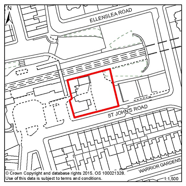
Figure 65: CLB2 – Taxi Office/B.R. Social Club, St Johns Road
Site address: Taxi Office/B.R. Social Club, St Johns
Road
Allocated use: Mixed use (residential and commercial)
Area: 0.12ha
Possible net capacity: 30
6.195 Site CLB2 – Taxi Office/B.R. Social Club, St Johns Road represents a redevelopment opportunity to create a building of distinctive design, quality and character that would act as a catalyst for the broader regeneration of Central St Leonards.
6.196 The Council wish to encourage a vibrant active street level frontage to the station forecourt and St John's Road occupied by commercial uses, with residential above. Although the possible net capacity is set at 30 dwellings, consideration would be given to a larger number, subject to Policy CLB2 and other policies in the Local Plan. The site will be expected to support a varied housing mix, including affordable housing.
6.197 Located within the Kings Road Conservation Area, new development would need to be high quality, complement the existing urban form, and enhance the architectural value of the existing buildings. Specific importance is attached to the relationship with the existing buildings along St John's Road, particularly in regard to privacy and overlooking. The relationship with the attractive station buildings to the west is also important.
6.198 The site is located in an area of surface water flood risk and given the previous uses of this site, there is also potential for land contamination.
6.199 No vehicular access will be permitted from the station forecourt. All vehicular access will need to occur from St John's Road. The capacity potential of this site indicates that a Transport Report will be required. Further advice on transport matters is available from East Sussex County Council.
Policy CLB2 -Taxi Office/B.R. Social Club, St Johns Road
The Taxi Office/B.R. Social Club, St Johns Road is allocated for mixed use development (possible net capacity 30 dwellings).
Development proposals for this site will:
Additional guidance is also given in a design brief for this site in section 5 of this Plan.
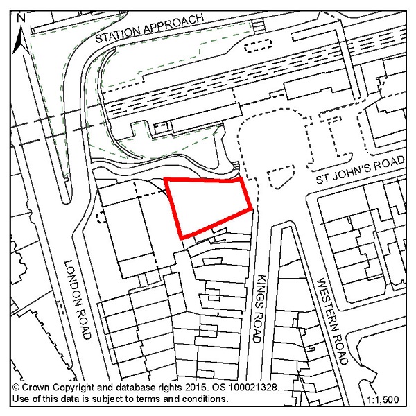
Figure 66: CLB3 – Sorting Office site, Kings Road
Site address: Sorting Office site, Kings Road
Allocated use: Mixed use (commercial with residential
above)
Area: 0.05ha
Possible net capacity: 9
6.200 Site CLB3 – Sorting Office site, Kings Road is a vacant and cleared site, occupying an area in the south-west corner of Warrior Square Station. It abuts the Kings Road shopping area on its southern side. Both the shopping street and station are within the Kings Road Conservation Area and the application site occupies an important position between the two. The capacity potential of this site indicates that a Transport Report will be required. Further advice on transport matters is available from East Sussex County Council.
Policy CLB3 - Sorting Office site, Kings Road
The Sorting Office site, Kings Road is allocated for mixed use development (possible net capacity 9 dwellings).
Development proposals for this site will:
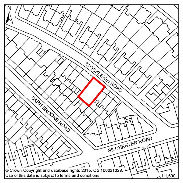
Figure 67: CLB4 – 4-5 Stockleigh Road
Site address: 4-5 Stockleigh Road
Allocated use: Residential
Area: 0.03ha
Possible net capacity: 12
6.201 Site CLB4 – 4-5 Stockleigh Road is a vacant site, located between bay fronted Victorian terraces and Stockleigh Court. The site is within the St Leonards North Conservation Area. The capacity potential of this site indicates that a Transport Report will be required. Further advice on transport matters is available from East Sussex County Council.
Policy CLB4 - 4-5 Stockleigh Road
4-5 Stockleigh Road is allocated for residential development (possible net capacity 12 dwellings).
Development proposals for this site will:

© Crown Copyright and database rights [2015]. OS [100021328]. Use of this data is subject to terms and conditions.
Figure 68: Focus Area 8 – Hastings Town Centre
6.202 This Focus Area is the commercial and retail heart of the Borough, extending from the Old Town in the east to White Rock in the west, and inland as far as Summerfields Wood and the railway line between London and Ashford. Most of the town's comparison retail trade takes place here, and the tightly constrained physical boundaries of Hastings have generally prevented the development of out-of-town shopping.
6.203 Hastings Town Centre has a good representation of national high street retail, catering and other business chains and there are also many independent shops, cafés and bars. The latter are predominantly in the traditional shopping areas along Robertson Street, Queens Road, and in St Andrew's Square and Queens Arcade. Morrisons supermarket also occupies a significant part of this Focus Area. Many of the shops in Hastings Town Centre are Victorian, although newer buildings have replaced them in some areas, notably in the modern Priory Meadow Shopping Centre, where the Victorian cricket ground on which it stands is remembered with the bronze sculpture of a batsman.
6.204 The architecture of Hastings Town Centre takes on many forms and patterns. There are Victorian terraces; mid-20th Century retail blocks and very recent retail, office and educational developments. There are also many separate and distinct buildings including Pelham Crescent, St Mary in the Castle and the Brassey Institute. There are also lesser known gems too, such as the Victorian warehouses along Earl Street. This is another Focus Area where eclectic architecture has, and continues to, help define its character. There are tourist attractions, such as the White Rock Theatre, Hastings Museum and Art Gallery, and the seafront itself. And there are residential areas too, predominantly around St Andrew's Square, Wellington Square and Holmsdale Gardens.
6.205 Significant regeneration has taken place, notably the Lacuna Place development and 1 Priory Square, Sussex Coast College, the improved railway station, a new health centre and the Hastings campus of the University of Brighton. Major improvements to the seafront through 'grotbuster' enforcement action, with many of the formerly derelict seafront buildings now refurbished and back in use, have also occurred. But significant regeneration challenges remain: White Rock Baths, the Observer Building, and Hastings Pier all remain out of use, although the pier does now have a hopeful future, thanks to the Hastings Pier and White Rock Trust.
6.206 Around 3,500 people live in Hastings Town Centre (according to 2001 Census data), and these are predominantly young adults. Almost 50% of the houses in this Focus Area are owned by their occupants. However, a relatively high proportion (38%) of homes are privately rented and a number of them are Homes in Multiple Occupancy, which suggests a relatively transient population. Around a fifth of the working age population of this Focus Area is in receipt of Job Seeker's Allowance (Department of Work and Pensions – Nomis statistics). The residents are able to access a high level of services and facilities: doctors, dentists, a library and more, all within the Town Centre, but the good public transport connections, especially at Hastings' railway station and the adjoining bus interchange, provide the opportunity to travel further afield.
6.207 Conservation areas cover much of the Hastings Town Centre Focus Area, and because of this, there are extra guidelines over what form development can take. It will be important for many features of the Focus Area to be preserved and enhanced; nevertheless there are still considerable redevelopment opportunities where innovation and excitement can prevail. Consideration will be given to the appropriate inclusion of taller buildings.
6.208 Outlined in the Planning Strategy (Policy FA2) is the potential for another 20,500 square metres of comparison retail floor space, and this should be accommodated within the Town Centre boundary, so redevelopment opportunities could be suggested.
6.209 In particular, we want to see the development of Priory Quarter continued, including the rest of Havelock Road north of Lacuna Place, Queensbury House, and Priory Street, to create employment, retail and leisure uses. The Observer Building needs to be brought back into use too.
6.210 There are opportunities in Hastings Town Centre for residential development – town centres are a good location for homes, particularly good-quality flats that can also serve as starter homes for young people. Introducing new housing into town centres can improve the balance and 'feel' of a place, especially at night. Policy FA2 of the Planning Strategy sets the range of new homes to be provided in Hastings Town Centre up to 2028 at 200-240.
6.211 Improvement and refurbishment of some of the residential areas and tourist accommodation has begun in the Focus Area and we will encourage the continuation and expansion of this, where appropriate, across Hasting Town Centre.
6.212 On the seafront, we expect to see Hastings Pier and White Rock Baths brought back into use. We will do all we can to help Hastings Pier and White Rock Trust build a modern, regenerated pier, and will help the Foreshore Trust get White Rock Baths back in use, with possible temporary uses for the upper parts initially. Further east, we anticipate that the seafront will continue to be used for leisure and catering purposes, although would hope to see these further developed and improved.
| Site reference | Address | Allocation (including potential number of homes) | Area (ha) | Does the site have a brief in section 5? |
| HTC1 | Hastings Station Yard (part) | Mixed residential (27) | 0.44 | ✖ |
| HTC2 | Cornwallis Street Car Park | Residential (10) | 0.22 | ✖ |
| HTC3 | The Observer Building (part) | Mixed use (39) | 0.07 | ✖ |
| HTC4 | 40 and 41 Wellington Square | Residential (12) | 0.02 | ✖ |
Table 10: Residential, mixed use and other allocations for Hastings Town Centre
| Site reference | Address | Potential gross floorspace (m2) | Area (ha) | Does the site have a brief in section 5? |
| HTC6 | Priory Quarter, Havelock Road | 21,700 | 2.54 | ✔ |
Table 11: Employment allocations for Hastings Town Centre
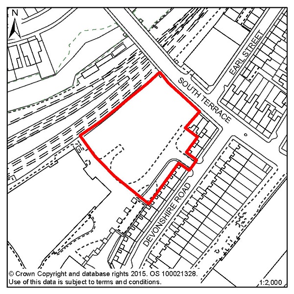
Figure 69: HTC1 – Hastings Station Yard (part)
Site address: Hastings Station Yard (part)
Allocated use: Mixed residential
Area: 0.44ha
Possible net capacity: 27
6.213 Site HTC1 – Hastings Station Yard (part) the majority of which has already been redeveloped for educational (Sussex Coast College) and health care purposes, and includes a small retail element. The remaining part of the site continues to be suitable for residential use but may also be suited to a mixed use scheme including alternative residential uses such as student accommodation. The site will be expected to support a varied housing mix and to include affordable housing.
6.214 New development on HTC1 will have to take account of the amenity of adjoining residents, particularly those in Devonshire Road. HTC1 is located in an area deficient in open space, and the proposed strategic network of cycle routes runs along the northern boundary. The capacity potential of this site indicates that a Transport Report will be required. Further advice on transport matters is available from East Sussex County Council. Water infrastructure also crosses the site, which will require easement as part of new development.
Policy HTC1 - Hastings Station Yard (part)
Hastings Station Yard (part) is allocated for mixed residential development; use class C3 with possible net capacity 27 units and student accommodation.
Development proposals for this site will:
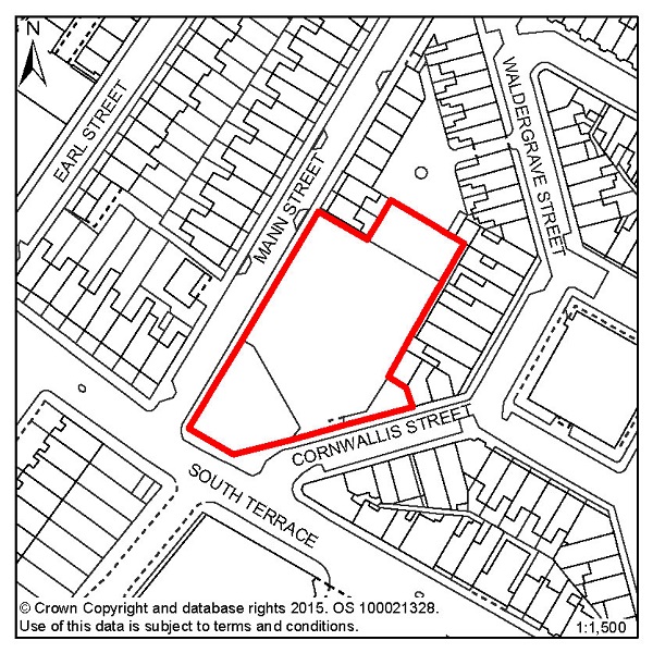
Figure 70: HTC2 – Cornwallis Street Car Park
Site address: Cornwallis Street Car Park
Allocated use: Residential
Area: 0.22ha
Possible net capacity: 10
6.215 Site HTC2 - Cornwallis Street Car Park is located in Hastings Town Centre near to other residential properties and incorporates an existing access route from Cornwallis Street. Flood Zone 2 extends towards the north corner of the site so a Flood Risk Assessment will be required, and mitigation as advised by the report should be incorporated into any potential scheme.
6.216 The loss of parking provision through the redevelopment of the car park will also need to be addressed in future proposals. The capacity potential of this site indicates that a Transport Report will be required. Further advice on transport matters is available from East Sussex County Council.
Policy HTC2 - Cornwallis Street Car Park
Cornwallis Street car park is allocated for residential development (possible net capacity 10 dwellings).
Development proposals for this site will:
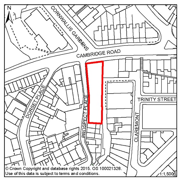
Figure 71: HTC3 – The Observer Building
Site address: The Observer Building
Allocated use: Mixed use (residential and commercial)
Area: 0.07ha
Possible net capacity: 39
6.217 HTC3 – The Observer Building is allocated for mixed use development. The Council would encourage the mix of uses to include tourist accommodation, retail, educational or leisure facilities as well as residential units. The site will be expected to support a varied housing mix and to include affordable housing.
6.218 This is a vacant multi-storey building occupying a prominent position on a route into Hastings Town Centre. It is located in the Town Centre Conservation Area and adjacent to 2 listed buildings.
6.219 There is currently no parking provision or access (other than pedestrian) to serve the site. The capacity potential of this site indicates that a Transport Statement will be required. Further advice on transport matters is available from East Sussex County Council.
6.220 Previous uses of the building may mean that there are contamination issues that need to be investigated, and the site falls within an Archaeological Notification Area. Southern Water has also indicated that a connection will be required to the nearest sewer and there is potential to release capacity through surface water removal.
Policy HTC3 - The Observer Building
The Observer Building is allocated for mixed use development including residential, commercial and/or educational uses (possible net capacity 39 dwellings).
Development proposals for this site will:
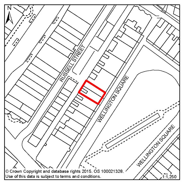
Figure 72: HTC4 – 40 and 41 Wellington Square
Site address: 40 and 41 Wellington Square
Allocated use: Residential
Area: 0.02ha
Possible net capacity: 12
6.221 Site HTC4 – 40 and 41 Wellington Square is within the Old Town Conservation Area. All the buildings in Wellington Square are listed in recognition of their importance as a group. The site also falls within an Archaeological Notification Area. The capacity potential of this site indicates that a Transport Report will be required. Further advice on transport matters is available from East Sussex County Council.
Policy HTC4 - 40 and 41 Wellington Square
40 and 41 Wellington Square is allocated for residential development (possible net capacity 12 dwellings).
Development proposals for this site will:
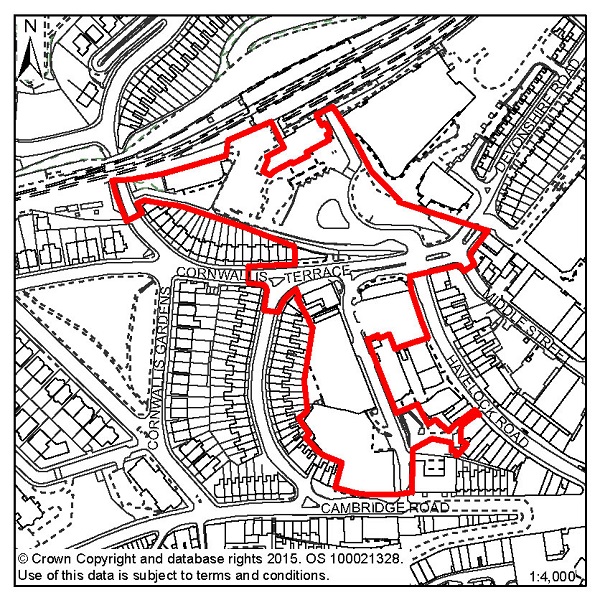
Figure 73: HTC6 – Priory Quarter, Havelock Road
Site address: Priory Quarter, Havelock Road
Allocated use: Employment - use class B1 (and mixed
use – Retail, use classes A1/A3; Hotel, use class C1; Education,
use class D1; Leisure, use class D2; Car Parking, sui generis use class)
Area: 2.54ha
Possible floorspace (gross): 21,700m2 (of
use class B1)
6.222 Site HTC6 – Priory Quarter, Havelock Road has outline planning permission (subject to a legal agreement) for a large scale mixed use development comprising offices, education, retail and leisure. It encompasses a significant part of the Academic Cultural Quarter, and is allocated primarily for business development, but also allows for other complementary uses - retail, education, car parking, hotel and/or leisure proposals, should they come forward.
6.223 Site HTC6 is located within the Town Centre Conservation Area and is in an Archaeological Notification Area. Deep surface water flood risk affects parts of the site, and the proposed strategic network of cycle routes runs though the northern end.
6.224 A design brief has been prepared to help guide development in this location (see section 5 of this Plan). The following phasing of development is considered appropriate:
6.225 Future redevelopment should consider re-arrangement of the station forecourt area to improve pedestrian circulation and connectivity, as well as the removal of through traffic from Priory Street to provide a safe and improved pedestrian route through the core of Priory Quarter. The proposed scale of development also provides the opportunity to support the introduction of district heating in the town centre. The capacity potential of this site indicates that a Transport Assessment and Travel Plan will be required. Further advice on transport matters is available from East Sussex County Council. Any redevelopment proposal on the Royal Mail site will have to take account of the relocation of its existing operation on a viable site. Any future development on adjacent sites should ensure Royal Mail operations are not negatively affected.
Policy HTC6 - Priory Quarter, Havelock Road
Priory Quarter, Havelock Road is allocated for employment development, incorporating other complementary uses including education, retail, leisure and hotel uses as appropriate (indicative gross floorspace 21,700m2 of use class B1).
Development proposals for this site will:
Additional guidance for this site is set out in a design brief in section 5 of this Plan.

© Crown Copyright and database rights [2015]. OS [100021328]. Use of this data is subject to terms and conditions.
Figure 74: Focus Area 9 – Old Town
6.226 Hastings Old Town is the oldest part of the Borough, extending between the East and West Hill from the iconic net shops on the beach, up to All Saints Church at the head of The Bourne. Some of the housing and other buildings here date back to the thirteenth century, woven through a maze of narrow streets and twittens that delight both visitors and residents.
6.227 The Old Town has had a mixed history of twentieth century planning. For example, the demolition of housing along The Bourne to create a route for the A259 effectively divided the area in two and was a low point, but there are large areas of sympathetic 1970s redevelopment. The Old Town remains a desirable place to live and house prices here are the highest in Hastings. It is also the densest housing in the town, with few open spaces, although it is very close to the Country Park and West Hill. All of the Old Town is in a conservation area, and many of the buildings are Grade II listed.
6.228 2001 Census data shows that the population in the Old Town is the oldest in the Borough, with around a third above retirement age. By contrast, only a tenth of the population is under 16, the lowest in the Borough. New community facilities at the Stade Hall help to provide a centre for local community activities, and the area is reasonably well served by other community services with the Stables Theatre, a doctor's surgery, pharmacy, and local food shops.
6.229 There is various employment in this Focus Area; the Hastings fishery at the Stade, with its direct employment of fishermen, as well as many indirect jobs, in related onshore trades, and the tourism that the fishing industry brings with it. There is much employment in retail and catering too, with a thriving network of busy, independent shops and cafes and pubs along George Street, High Street and Rock-a-Nore. There is also a wealth of small studios and workshops, used largely by working artists and other craft-related trades. There is also some more seasonal employment concentrated on 'traditional' tourism, with souvenir shops, amusements and all that is on offer on the seafront.
6.230 New development has taken place in the Old Town in recent years, most notably the Jerwood Gallery, Stade Open Space, café and Stade Hall, with the style and design of this being modern and creative but sympathetic to its setting. There is a new hotel in Rock-a-Nore being built, replacing the old ice house that had been derelict for many years. This helps to give visitors to Hastings a wide range of things to see and do during their time here, from traditional seaside amusements, to eating and drinking, to art appreciation and everything in between.
6.231 Since the charm of the Old Town, and its value as a place to live and work, is dependent on its centuries-old character, any new development would have to be sympathetic to this. Almost all of the buildings in the area should be maintained and preserved in their current form, retaining its rich architectural heritage. But this does not mean that there should not be any new development. So we will allow new development in the Old Town, where this complements the existing townscape and does not damage existing historic buildings, both in terms of their physical structure and their visual setting. Any new development here would have to be carried out to the highest architectural quality. But that doesn't mean it has to be a mock-historical pastiche; the Old Town must continue to grow and react to changing times.
6.232 This approach obviously raises potential conflicts, in particular between businesses wanting to develop opportunities, and the need to conserve architectural heritage. So while we will continue to pay close attention to the materials and construction techniques used in the conversion of existing buildings, we will work with those looking to develop schemes and help them to achieve their aims and aspirations whilst the character and important buildings of the Old Town are preserved for future generations.
6.233 Policy FA5 of the Planning Strategy sets out a range of 50-70 new homes to be built in the Old Town up to 2028, but businesses and new jobs will be just as important. With the average age of the local population growing, and being significantly higher than the rest of the borough, it is important to make sure that young people can remain in the area. That will be difficult if there are no jobs apart from seasonal, tourism-related jobs, and no affordable housing. So we need to promote the creation of both affordable housing, and sustainable employment, particularly with small employers in the creative sector.

© Crown Copyright and database rights [2015]. OS [100021328]. Use of this data is subject to terms and conditions.
Figure 75: Focus Area 10 – West Hill
6.234 The West Hill Focus Area is made up of mostly terraced Victorian housing, stretching from the West Hill open space, with its spectacular views across the town and sea, to Mount Pleasant in the west and Torfield allotments in the east, while extending to the north as far to the edge of Halton Estate.
6.235 At the southern end stands the Borough's only Grade I Listed building: Hastings Castle. The houses near the Castle are elegant, seaside villas. Some of the big, cliff top hotels and boarding houses have also been converted into flats or Houses in Multiple Occupation.
6.236 Moving inland, the houses are larger and more densely packed. Streets here are narrow and lined with parked cars, with few open spaces between, giving the feel of a crowded, highly populated area. Families with children predominate: the area has the lowest proportion of retired people in the Borough, but the second highest proportion of children under 16, according to 2001 Census data.
6.237 Some gentrification has taken place in the terraced cottages closest to the cliffs, with many of these having been refurbished and turned into holiday lets or weekend retreats. Most of the housing here is private, beyond a few small infill blocks of ex-council flats.
6.238 2001 Census data supports that this is a busy, densely populated part of town, with over 5,500 people living here, in one of the smallest Focus Areas. The density of population does mean that corner shops, small businesses and local pubs have survived relatively well. There are even some 'traditional' workshops and light engineering businesses, mixed in amongst the Victorian terraces. One fifth of the working age population, however, is in receipt of Job Seeker's Allowance (Department of Work and Pensions – Nomis statistics). While the area is well served by open spaces and children's play areas, these are all at the southern and eastern edges of the area.
6.239 Hastings Castle, owned by the Council, needs considerable investment to bring it up to standard as a tourist destination, making the most of its status as one of the world's most famous buildings. The vista of open space and elegant housing that surrounds the castle should be preserved. We would, however, encourage the continued development of holiday accommodation in this 'cliff top zone', helping the renovation and regeneration of housing back along the streets that lead away from the sea. With local shops serving a community of holidaymakers and residents enjoying sea views and sunshine amongst pretty, colourful streets and seaside gardens, this part of the Borough will continue to be a prime destination.
6.240 However, this whole Focus Area contains few opportunities for new development, and the densely packed terraces would make this difficult. Policy FA2 of the Planning Strategy suggests a range of 50-70 new homes to be provided in this area up to 2028, and the redevelopment and reuse of existing buildings will be an important part of this. Potential development schemes would have to pay particular attention to local population density, the setting of the Castle, and be sympathetic to the character of the Victorian terraces and to the open aspect of the West Hill itself.
6.241 The small local shops and businesses in this area are one of its assets, so we would want to preserve and improve these. We would look favourably, too, on ideas for new small businesses, especially from the creative sector. Artists' studios and workshops in particular would fit in with the feel and atmosphere of the southern part of the area.

© Crown Copyright and database rights [2015]. OS [100021328]. Use of this data is subject to terms and conditions.
Figure 76: Focus Area 11 – Hillcrest & Ore Valley
6.242 This t-shaped Focus Area, which includes housing predominantly in mid-twentieth century estates, sweeps up from the West Hill to the Ridge and North's Seat, and borders some of the best natural green spaces in town. The quality of the buildings often appears to be in contrast with the spectacular views towards the sea and also northwards to the High Weald Area of Outstanding Natural Beauty. Ore Valley & Hillcrest also includes the Ivyhouse Lane industrial estate, one of the Borough's principle employment areas. This is on the northern edge of the area and is somewhat disconnected from the many areas of housing that predominate here.
6.243 Hillcrest & Ore Valley is dominated by social housing, in estates built between the 1950s and 70s: Halton, Farley Bank, Broomgrove, Red Lake and Downs Farm. While some of this housing is semi-detached housing with gardens (as in Red Lake), much of it is flats and maisonettes. Attempts have been made to introduce a more diverse mix of housing, with some blocks of flats being demolished. But land values are low and there has been little interest shown by developers, so the sites remain as development potential yet to be realised.
6.244 This area also includes the Ore Valley regeneration site area, formerly a 'Millennium Communities' project, comprising an old railway goods yard and power station. Here, some redevelopment has been completed, with housing built around a new road to the Ore railway station, and new offices and shops provided.
6.245 The statistics for this Focus Area make for hard reading: over 60% of children live in households below the official UK poverty level (ONS), and there is the highest proportion of children for a Focus Area in the Borough. Roughly one fifth of the working age population is on Job Seeker's Allowance (Department of Work and Pensions – Nomis statistics). Educational and training opportunities are improving significantly though, with the new Sussex Coast College opened in the Ore Valley regeneration area, and the new Hastings Academy at the Hillcrest School site. Other services include community centres and a 'Sure Start' children's centre, but opportunities to increase what is available remain, especially in terms of local retail.
6.246 There are already significant redevelopment opportunities on vacant sites at Broomgrove and the Ore Valley. Policy FA5 of the Planning Strategy indicates a range of 440-540 homes in this area up to 2028. A better mix of housing tenures is needed, but any large-scale redevelopment would have to take account of the local economic circumstances, meaning that the current levels of social housing would need to be retained overall, albeit with a better, more integrated mix. While new housing on currently vacant sites could be offered for sale, this is an ideal area for low-cost 'starter' homes, giving local social housing tenants a route into property ownership.
6.247 One of the biggest challenges in this Focus Area is the lack of employment opportunities, and the alienation of its young people. To tackle this, we think it is important to bring employment opportunities back into the community, so young people can get jobs locally, go to work, and get paid. So, as well as protecting and improving existing employment land and industrial areas, particularly the Ivyhouse Lane employment area, we want to encourage the development of small businesses within the community – including live/work units, micro-engineering workshops, high-tech internet-based employers, along with more 'traditional' local businesses, such as car repairers and builders. Some of these could be retail units, providing not only employment, but also much-needed local services.
6.248 We must also protect green spaces in the area, which provide an important recreational opportunity especially for children. So where development does occur, the opportunities to help protect and enhance open spaces will be encouraged along with, where appropriate, the provision of children's play equipment.
| Site reference | Address | Allocation (including potential number of homes) | Area (ha) | Does the site have a brief in section 5? |
| HOV1 | Former Stills Factory, Ore Valley | Residential (75) | 2.71 | ✔ |
| HOV2 | Ore Valley | Residential (50) | 2.35 | ✔ |
| HOV3 | Former Mount Pleasant Hospital, Frederick Road | Residential (40) | 1.84 | ✔ |
| HOV4 | The Cheviots/Cotswold Close | Residential (79) | 1.23 | X |
| HOV5 | 87-221 (odds) Farley Bank | Residential (29) | 0.73 | X |
| HOV6 | Ore Business Park, Farley Bank | Residential (19) | 0.70 | X |
| HOV7 | Upper Broomgrove Road | Residential (12) | 0.28 | X |
| HOV9 | 107 The Ridge (Simes & Sons) | Residential (8) | 0.22 | X |
Table 12: Residential, mixed use and other allocations for Hillcrest & Ore Valley
| Site reference | Address | Potential gross floorspace (m2) | Area (ha) | Does the site have a brief in section 5? |
| HOV11 | Ivyhouse Lane, Northern Extension | 7,000 | 5.80 | ✔ |
| HOV12 | Land east of Burgess Road, Ivyhouse | 1,400 | 0.51 | X |
Table 13: Employment allocations for Hillcrest & Ore Valley
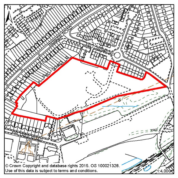
Figure 77: HOV1 – Former Stills Factory, Ore Valley
Site address: Former Stills Factory, Ore Valley
Allocated use: Residential
Area: 2.71ha
Possible net capacity: 75
6.249 Site HOV1 – Former Stills Factory forms part of a wider area known as Ore Valley, the regeneration of which has been a long term objective of the Council. Through the former Millennium Communities programme, Sussex Coast College and the first phase of housing has already been completed. Whilst the Millennium Communities programme has now ended, the remaining sites continue to be allocated for development.
6.250 The neighbouring site HOV2 – Ore Valley, gives the opportunity for more comprehensive planning of the area, particularly in respect of achieving pedestrian and cycle routes between the two sites. The site will be expected to support a varied housing mix, including affordable housing. Given the previous uses of this site there is the potential for contamination, which would need to be investigated. The capacity potential of this site indicates that a Transport Statement will be required. Further advice on transport matters is available from East Sussex County Council.
6.251 The site encompasses trees and shrubs on all boundaries, as well as two significant groups of trees within the site itself. A Local Wildlife Site is also located nearby.
6.252 Southern Water has indicated there is currently insufficient sewerage capacity to serve the site, which will need to be addressed in development proposals. The size of the site is over 1 hectare, and therefore requires a Flood Risk Assessment.
Policy HOV1 - Former Stills Factory, Ore Valley
The Former Stills Factory is allocated for residential development (possible net capacity 75 dwellings).
Development proposals for this site will:
Additional guidance (that includes opportunities to connect to adjoining sites) is also given in a design brief for this site in section 5 of this Plan
.
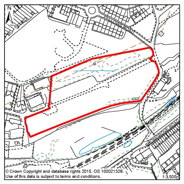
Figure 78: HOV2 – Ore Valley
Site address: Ore Valley
Allocated use: Residential
Area: 2.35ha
Possible net capacity: 50
6.253 Site HOV2 – Ore Valley forms part of a wider Ore Valley regeneration area, the redevelopment and regeneration of which has been a long term objective of the Council. Through the former Millennium Communities programme, Sussex Coast College and the first phase of housing has already been completed. Whilst the Millennium Communities programme has now ended, the remaining sites continue to be allocated for development.
6.254 The neighbouring site HOV1 gives the opportunity for more comprehensive planning of the area, particularly in respect of achieving pedestrian and cycle routes between the two sites. The site will be expected to support a varied housing mix, including affordable housing. Given the previous uses of this site there is potential for contamination, which would need to be investigated. The capacity potential of this site indicates that a Transport Statement and Travel Plan Statement will be required. Further advice on transport matters is available from East Sussex County Council.
6.255 The developable parts of this site are confined to the southern half and a smaller area to the north. The remainder of the site is woodland, which should be retained and arrangements made for its management. Access is available from an existing access point to Fellows Road at the eastern end of the site. If achievable, a vehicular, pedestrian and cycle link to the south should be provided to link with the phase 1 development and the open space area.
6.256 The site is located in an area of deep surface water flood risk, and Southern Water has indicated that there is currently insufficient sewerage capacity to serve the site. It is also located adjacent to a designated Local Wildlife Site, and will require its own ecological assessment in terms of future development.
6.257 The design brief that accompanies this site should be used as a reference to guide potential schemes (see section 5 of this Plan).
Policy HOV2 - Ore Valley
Ore Valley is allocated for residential development (possible net capacity 50 dwellings).
Development proposals for this site will:
Additional guidance (that includes opportunities to connect to adjoining sites) is also given in a design brief for this site in section 5 of this Plan.
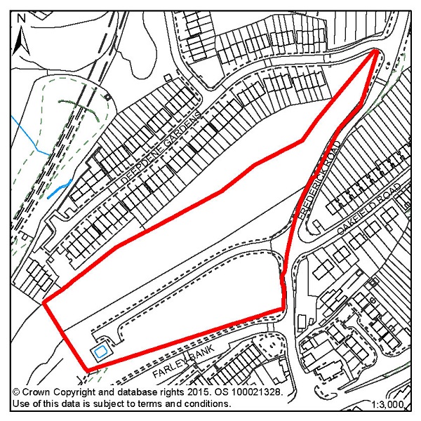
Figure 79: HOV3 – Former Mount Pleasant Hospital, Frederick Road
Site address: Former Mount Pleasant Hospital, Frederick
Road
Allocated use: Residential
Area: 1.84ha
Possible net capacity: 40
6.258 Site HOV3 – Former Mount Pleasant Hospital, Frederick Road forms part of a wider Ore Valley regeneration area, the redevelopment and regeneration of which has been a long term objective of the Council. Through the former Millennium Communities programme, Sussex Coast College and the first phase of housing has already been completed. Whilst the Millennium Communities programme has now ended, the remaining sites continue to be allocated for development.
6.259 A spine road to service the site runs north-east to south-west along the centre of the site. The position of the spine road together with the narrowness of the site suggests that housing development is likely to take the form of frontage development on either side of the road, although there may be alternative approaches that might be acceptable, including more depth of development in the south-eastern part of the site. The site will be expected to support a varied housing mix, including affordable housing. A large drainage storage tank to the west of the turning head will need to be protected as part of future redevelopment. The capacity potential of this site indicates that a Transport Statement will be required. Further advice on transport matters is available from East Sussex County Council.
6.260 The proposed network of strategic cycle routes runs through the top part of the site, as well as an Ecology Zone. Due to the size of the site, a Flood Risk Assessment is required.
6.261 Southern Water has indicated that there is currently insufficient sewerage capacity to serve the site.
Policy HOV3 - Former Mount Pleasant Hospital, Frederick Road
The Former Mount Pleasant Hospital, Frederick Road is allocated for residential development (possible net capacity 40 dwellings).
Development proposals for this site will:
Additional guidance (that includes opportunities to connect to adjoining sites) is also given in a design brief for this site in section 5 of this Plan.
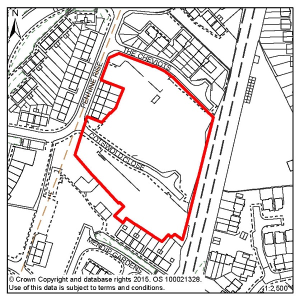
Figure 80: HOV4 – The Cheviots/Cotswold Close
Site address: The Cheviots/Cotswold Close
Allocated use: Residential
Area: 1.23ha
Possible net capacity: 79
6.262 HOV4 – The Cheviots/Cotswold Close, in view of the site's potential capacity and location, will be expected to support a varied housing mix including affordable housing. Southern Water has indicated that water supply and wastewater infrastructure crosses the site and there is insufficient sewerage capacity. This underground infrastructure will require easement to allow for future maintenance and upgrading or could potentially be diverted at the developer's expense. Due to the size of the site, a Flood Risk Assessment is required. Development proposals will need to show consideration of the transport impact along The Ridge. Further advice on transport matters is available from East Sussex County Council.
Policy HOV4 - The Cheviots/Cotswold Close
The Cheviots/Cotswold Close site is allocated for residential development (possible net capacity 79 dwellings).
Development proposals for this site will:
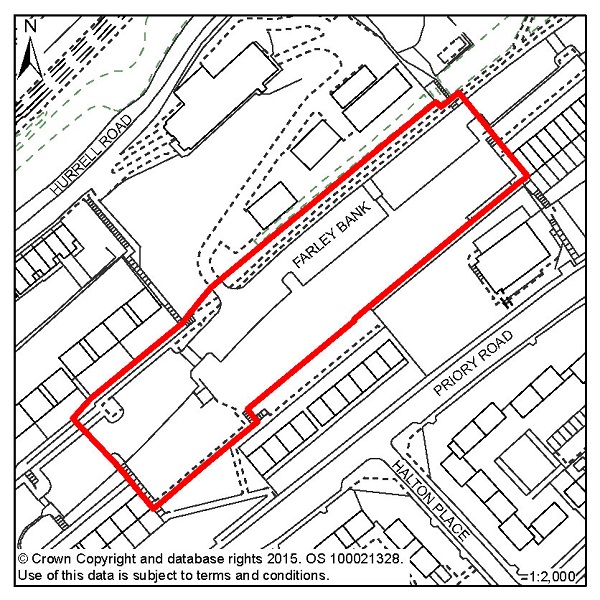
Figure 81: HOV5 – 87-221 (odds) Farley Bank
Site address: 87-221 (odds) Farley Bank
Allocated use: Residential
Area: 0.73ha
Possible net capacity: 29
6.263 Site HOV5 – 87-221 (odds) Farley will be expected to support a varied housing mix including affordable housing. Southern Water has indicated that water supply and wastewater infrastructure crosses site and there is insufficient sewerage capacity. The capacity potential of this site indicates that a Transport Report will be required. Further advice on transport matters is available from East Sussex County Council.
Policy HOV5 - 87-221 (odds) Farley Bank
87-221 (odds) Farley Bank is allocated for residential development (possible net capacity 29 dwellings).
Development proposals for this site will:
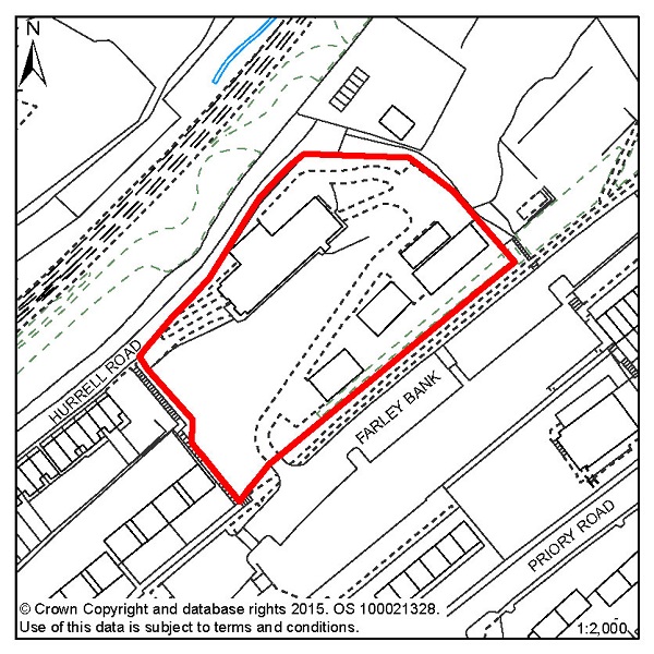
Figure 82: HOV6 – Ore Business Park, Farley Bank
Site address: Ore Business Park, Farley Bank
Allocated use: Residential
Area: 0.70ha
Possible net capacity: 19
6.264 Site HOV6 – Ore Business Park, Farley Bank is currently occupied by single storey industrial units although some have been demolished. It is allocated for residential development and will be expected to support a varied housing mix, including affordable housing.
6.265 The site lies adjacent to a designated Local Wildlife Site and Southern Water has indicated that there is currently insufficient sewerage capacity. The proposed strategic network of cycle routes runs through the site. The capacity potential of this site indicates that a Transport Report will be required. Further advice on transport matters is available from East Sussex County Council.
Policy HOV6 - Ore Business Park, Farley Bank
Ore Business Park, Farley Bank is allocated for residential development (possible net capacity 19 dwellings).
Development proposals for this site will:
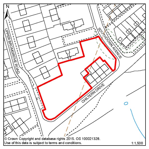
Figure 83: HOV7 – Upper Broomgrove Road
Site address: Upper Broomgrove Road
Allocated use: Residential
Area: 0.28ha
Possible net capacity: 12
6.266 Site HOV7 – Upper Broomgrove Road is a vacant site formally occupied by flats. A designated Local Wildlife Site runs directly adjacent to the proposed development site, with various trees and other wildlife being present on the site itself. A high voltage power line also dissects the site in a north-south direction. The capacity potential of this site indicates that a Transport Report will be required. Further advice on transport matters is available from East Sussex County Council.
Policy HOV7 - Upper Broomgrove Road
Upper Broomgrove Road is allocated for residential development (possible net capacity 12 dwellings).
Development proposals for this site will:
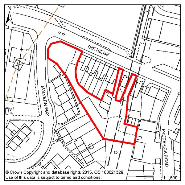
Figure 84: HOV9 – 107 The Ridge (Simes & Sons)
Site address:
107 The Ridge (Simes & Sons)
Allocated use:
Residential
Area:
0.22ha
Possible net capacity: 8
6.267 Site HOV9 – 107 The Ridge (Simes & Sons) is a former industrial site, located on The Ridge, one of the main roads that runs across the north of the town. The site is of an irregular shape and access needs to be carefully considered. The eastern section of the site lies over the Ore railway tunnel. Development proposals will need to show consideration of the transport impact along The Ridge. Further advice on transport matters is available from East Sussex County Council.
6.268 The site falls within an Archaeological Notification Area. There is also potential for contamination on the site, which would need to be investigated in future proposals.
Policy HOV9 – 107 The Ridge (Simes & Sons)
107 The Ridge is allocated for residential development (possible net capacity 8 dwellings).
Development proposals for this site will:
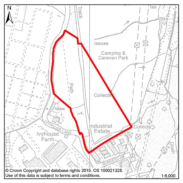
Figure 85: HOV11 – Ivyhouse Lane, Northern Extension
Site address: Ivyhouse Lane, Northern Extension
Allocated use: Employment; B use classes
Area: 5.80ha
Potential floorspace (gross): 7,000m2
6.269 Site HOV11 – Ivyhouse Lane, Northern Extension is located on the northern edge of the urban area, accessed off The Ridge. It is an undeveloped site, which would form a natural extension to the existing Ivyhouse employment area.
6.270 The High Weald Area of Outstanding Natural Beauty extends to the edge of the built up area of Hastings and the site itself falls within it. Although the site has been allocated to meet strategic employment needs, any development must take full account of the site's intrinsic value (including existing trees and hedges), the effect on its setting, and views of it from other parts of the AONB – in particular from the Rock Lane area from where it is visible.
6.271 The eastern boundary of the identified site is defined by the Borough's administrative boundary rather than existing physical divisions on the ground and so, to be acceptable, a scheme should be designed such that it creates a new logical boundary. While the access at the southern end of the site would minimise industrialising the character of Ivyhouse Lane, the possibility of access directly off Burgess Road (or the planned extension of it) may be an option, subject to Highway views. The Highway Authority may also require the creation of an emergency access point onto Ivyhouse Lane further to the north of the site.
6.272 The site contains a well-defined straight tree lined and sunken historic lane, which divides the site into two distinct areas. It is envisaged that the extent of built development will be in the southern part of the site, as shown indicatively on the design brief (either side of the historic lane), subject to new woodland planting and the retention and protection of existing trees. As well as the sunken lane, there are also a significant number of other trees within the site. The strength of the wooded character of the area provides a key characteristic feature upon which to develop a mitigation strategy. Due to the size of the site, a Flood Risk Assessment is required. Development proposals will need to show consideration of the transport impact along The Ridge. Further advice on transport matters is available from East Sussex County Council.
6.273 Hastings Borough Council and Rother District Council have agreed to work together on a joint approach to treatment and management of the fringes of Hastings to secure a clearer definition of the urban boundary and to protect and enhance the rural character of the countryside that immediately abuts it, as well as better access to it. Work on this is expected to produce more detailed guidance (in the form of a Supplementary Planning Document) on joint urban fringes management which, once available, is likely to further inform the development requirements for this site.
6.274 An initial design brief has been prepared to guide potential schemes (see section 5 of this Plan).
Policy HOV11 - Ivyhouse Lane, Northern Extension
Ivyhouse Lane, Northern Extension is allocated for employment (B use classes) development (potential gross floorspace 7,000m2).
Development proposals for this site will:
The applicant will be expected take into account the wider area within Rother District when considering development proposals for this site.
Additional guidance for this site is also set out in a Design Brief in section 5 of this Plan.
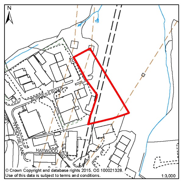
Figure 86: HOV12 – Land east of Burgess Road, Ivyhouse
Site address: Land east of Burgess Road, Ivyhouse
Allocated use: Employment; B use classes
Area: 0.51ha
Potential floorspace (gross): 1,400m2
6.275 Site HOV12 - Land east of Burgess Road, Ivyhouse potentially forms part of a larger area extending beyond the Borough boundary into Rother. Combined, the full potential development area is up to 1.5 hectares. The area within Rother is allocated to in Rother District Council's adopted local Plan, but this will be subject to review when it prepares its new Development Management Plan.
6.276 The site is mainly wooded and located within the High Weald Area of Outstanding Natural Beauty. Development must take full account of the site's intrinsic value, the effect on its setting, and views of it from other parts of the AONB. Ecological and landscape surveys of the site will be required. Development proposals will need to show consideration of the transport impact along The Ridge. Further advice on transport matters is available from East Sussex County Council. The site is traversed by high voltage transmission lines and so the utility provider should be consulted on any proposals.
6.277 As well as providing capacity for new employment floorspace, this development provides an opportunity to improve the ambiance and quality of the existing adjoining employment area.
6.278 Hastings Borough Council and Rother District Council have agreed to work together on a joint approach to treatment and management of the fringes of Hastings to secure a clearer definition of the urban boundary and to protect and enhance the rural character of the countryside that immediately abuts it, as well as better access to it. Work on this is expected to produce more detailed guidance on joint urban fringes management which is likely to further inform the development requirements for this site.
Policy HOV12 - Land east of Burgess Road, Ivyhouse
Land East of Burgess Road, Ivyhouse is allocated for employment (B use classes) development (potential gross floorspace 1,400m2).
Development proposals for this site will:
The applicant will be expected take into account the wider area within Rother District when considering development proposals for this site.

© Crown Copyright and database rights [2015]. OS [100021328]. Use of this data is subject to terms and conditions.
Figure 87: Focus Area 12 – Clive Vale & Ore Village
6.279 This Focus Area stretches up the Old London Road from the northern edge of the Old Town to the shopping centre at Ore. In the southern part of Clive Vale, grand Victorian villas enjoy spectacular sea views. To the north at Ore, the housing becomes part of the 'ribbon development' that took place in the nineteenth century in many English towns, along the main roads into the town centres.
6.280 Along this eastern edge, the area is bounded by Hastings Country Park, giving a semi-rural feel to houses where the gardens open out into countryside. The western edge is more urban and denser, with few open spaces. There is, however, a heavily wooded valley in the Upper Ore Valley that is in multiple ownership, and we are working towards a sustainable future for it.
6.281 The area is well served by shops, doctors and other community facilities, although these are largely in the northern part, at Ore Village. But there are also other smaller local shopping parades at Mount Road and Harold Road, to the south of the area. In Ore Village, however, these services and facilities do result in issues of traffic build-up, especially on the busy A259, where parking is scarce and footpaths are narrow.
6.282 According to 2001 Census data, there are 7,500 inhabitants here, making it one of the more densely populated Focus Areas. It is relatively affluent, however, with 83% of the homes owned by their occupants (Census data). Around 7% of the working population claims Job Seeker's Allowance (Department of Work and Pensions – Nomis statistics), but only about 2% of the housing is rented from Registered Social Landlords.
6.283 Apart from local shops, there is little employment in this area. The local Victorian trades that would once have been here have all but died out, beyond a few local car repairers and small workshops. In the Clive Vale part, there is a growing community of local artists and craftspeople who work out of home studios, but this is not a significant source of employment for local young people. This is a predominantly residential area, there are, however, good road and public transport links across the Borough and beyond to enable people to travel to work.
6.284 The character of this area is dominated by Victorian terraces and villas, with distant and often dramatic views of the sea. Any new development schemes in this Focus Area would need to be sympathetic to the Victorian patterns and rhythm of development in the area.
6.285 Policy FA5 of the Planning Strategy outlines a range of 250-310 new homes to be provided in Clive Vale & Ore Village up to 2028. Because of the shortage of affordable housing in the area, we will encourage developers to provide a mix of social housing tenures.
6.286 While Clive Vale & Ore Village are likely to remain largely residential, we would consider small-scale employment uses of existing or new property. These should not interfere with the predominantly residential character of the area, but 'artisan' trades – for example artist's studios, specialist craft workshops, specialist niche food makers like bakers or confectioners – could fit with and enhance the area, and provide some local jobs. Tourist accommodation, in the form of small 'boutique' hotels, might also be suitable in the grander houses at the seaward end of the area.
6.287 So while we recognise that we cannot set any areas in cultural aspic, we need to recognise and preserve what is best about Clive Vale & Ore Village, both their architecture and their rare open spaces. But we need to encourage economic development too, especially in Ore Village centre, where regeneration investment is still much needed.
| Site reference | Address | Allocation (including potential number of homes) | Area (ha) | Does the site have a brief in section 5? |
| CVO2 | Land west of Frederick Road | Residential (29) | 0.60 | X |
| CVO4 | Church Street | Residential (6) | 0.35 | X |
| CVO5 | 309-311 Harold Road | Residential (6) | 0.09 | X |
Table 14: Residential, mixed use and other allocations for Clive Vale & Ore Village
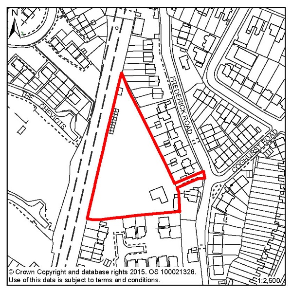
Figure 88: CVO2 – Land west of Frederick Road
Site address: Land west of Frederick Road
Allocated use: Residential
Area: 0.60ha
Possible net capacity: 29
6.288 Site CVO2 - Land west of Frederick Road is a brownfield site currently occupied by a single storey bungalow with various outbuildings and a paddock. There is no direct access onto Frederick Road, although a pedestrian and cycle access could be utilised through the existing driveway. Development proposals will need to show consideration of the transport impact along The Ridge. Further advice on transport matters is available from East Sussex County Council.
6.289 Southern Water has indicated that there is currently insufficient sewerage or water main capacity to serve the site. Given the size and location of the site the Council will expect any scheme to support a varied housing mix, including affordable housing.
Policy CVO2 - Land west of Frederick Road
Land west of Frederick Road is allocated for residential development (possible net capacity 29 dwellings).
Development proposals for this site will:
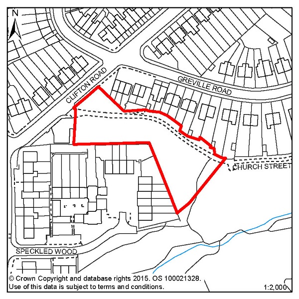
Figure 89: CVO4 – Church Street
Site address: Church Street
Allocated use: Residential
Area: 0.35ha
Possible net capacity: 6
6.290 Site CVO4 – Church Street comprises a small area of scrub and woodland that is relatively level. It presents an opportunity for a small amount of development, fronting onto Church Street. It is located adjacent to the Local Green Space in the Upper Ore Valley as identified on the Policies Map. The strategic network of cycle routes runs towards the south-east corner of the site. Development proposals will need to show consideration of the transport impact along The Ridge. Further advice on transport matters is available from East Sussex County Council.
Policy CVO4 - Church Street
Church Street is allocated for residential development (possible net capacity 6 dwellings).
Development proposals for this site will:
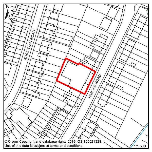
Figure 90: CVO5 – 309-311 Harold Road
Site address:
309-311 Harold Road
Allocated use:
Residential
Area:
0.09ha
Possible net capacity: 6
6.291 Site CVO5 - 309-311 Harold Road is a relatively small site in a residential area, and represents an opportunity for residential redevelopment. There is a Local Wildlife Site nearby and there is the potential for significant ecology on site. This will need to be surveyed and understood as part of the development process. The capacity potential of this site indicates that a Transport Report will be required. Further advice on transport matters is available from East Sussex County Council.
Policy CVO5 - 309-311 Harold Road
309-311 Harold Road is allocated for residential development (possible net capacity 6 dwellings).
Development proposals for this site will:

© Crown Copyright and database rights [2015]. OS [100021328]. Use of this data is subject to terms and conditions.
Figure 91: Focus Area 13 – Hastings Country Park
6.292 Hastings Country Park is Hastings' area of true countryside – and it is a very special area of countryside. Gradually acquired by the Borough Council over a century, it is made up of farmland, wooded glens and crumbling cliff tops that, together, make up an area of astonishing natural beauty; a wild, sea-edged landscape where rare plants and uncommon wildlife are present, in an environment little touched by development. This special character is recognised through the area's legal status too. Declared a nature reserve in 2006, it is a Site of Special Scientific Interest (SSSI), and also a Special Area of Conservation (SAC), a designation which gives it special protection under European law. But it is not a wilderness; people have lived and worked here for thousands of years, and the area has a wealth of archaeology to prove this.
6.293 The Country Park also includes within its boundaries the Shearbarn holiday village, one of the primary tourist accommodation sites in the Borough, with camping grounds, caravans and log cabins high on the clifftops looking out over the sea, as well as the smaller Rocklands caravan park.
6.294 The Hastings Country Park Focus Area takes in slightly more than the Country Park nature reserve, including the curiously named 'Bachelor's Bump' area at the north-east corner of the Borough. This is where most of the people in this area live, although there are a few small pockets of housing in the Country Park itself, mostly old agricultural housing, coastguard cottages, and the impressive Fairlight Place. Most of this housing is now in private ownership, although almost all of the Country Park is owned and managed by the Council. Even so, while this is the largest of our local Focus Areas by area, it is the smallest by population: only around 1,800 people live here, with over a quarter of them above retirement age (according to 2001 Census data).
6.295 The people who live in this Focus Area generally need to travel to access shops and services, as there are few within it. Road connections to Hastings Town Centre are good, and there are bus routes that pass through, and the presence of these is important to avoid problems of isolation.
6.296 This is an area where the natural environment is of paramount importance. That means maintaining the unspoilt character of the place for those who visit and live there, but more importantly, preserving the rare and sensitive habitats for the park's astonishingly varied flora and fauna.
6.297 Any development anywhere in the Country Park Focus Area would be tightly managed by existing planning restrictions that apply in SSSIs and the High Weald Area of Outstanding Natural Beauty (AONB), so we are not intending to identify much additional housing in this area to help us meet our overall housing target. Minor development outside of the Country Park itself could be considered, if it were unobtrusive and wholly in keeping with the character of the AONB and would not have an adverse effect on the integrity of the SAC. Within the park, any development would be limited to facilities that enhance the park environment and the 'visitor experience' – for example, a new visitor centre and café that fits with the Country Park's aesthetic, or buildings needed for low level sustainable agriculture. Any development would need to be sensitively built and in keeping with the natural environment. We would envisage that any structures in the park would be environmentally sensitive in their methods of construction, use of renewable energy and water conservation. Environmentally sensitive projects for sustainable energy generation could also be considered. We would want to retain tourist accommodation at Shearbarn and Rocklands too, although any development there would also need to be environmentally sensitive, and limited entirely to tourist accommodation.
6.298 The potential of the Country Park to help local people, especially young people, gain experience in the crafts and skills that are used to maintain an area like this should not be overlooked. So while there would be little additional housing development, there is the potential for employment uses, largely of existing buildings, which fosters this kind of activity.
< Previous | ^ Top | Next >