
Amos Park

This area-wide section outlines the policy approaches to key issues relevant to the future of the NCAAP area. The aims of these policies, and of the NCAAP itself, is to ensure a policy framework is in place to help ensure change to the area is sustainable and the area continues to service as a successful sustainable neighbourhood and suburb for its existing and new residents.
Launched in 2007, the Enfield Sustainable Community Strategy, prepared by the Enfield Strategic Partnership (ESP), was most recently updated in 2009 and is a ten year borough-wide strategy with the following purpose:
The Strategy has a range of objectives cutting across all Council service areas. These include objectives relating specifically to children and young people, safer and stronger communities, healthier communities, older people and improving the quality of life. It is the objectives under this final category which are most relevant to the NCAAP. Regarding the NCAAP specifically, the Strategy states that “There will be attractive and safe pedestrian environments, rejuvenated and new residential areas and an accessible network of green spaces. All of this will be supported by an improved social infrastructure, community facilities and increased opportunities for business development in the area.”
The North Circular area is an established sustainable suburban residential location and the NCAAP seeks to ensure that a positive planning policy framework is put in place which protects this function. In this context and in view of the Community Strategy’s wider objectives, the following factors are considered important:
A rich housing mix: The area should continue to provide a wide range of choices in terms of living accommodation. The NCAAP area benefits from a wide spectrum of house types and prices and therefore provides the opportunities for families to grow and for future generations to continue to stay living close together.
Provision to meet local shopping needs: The network of local centres and shopping parades ensures the everyday needs of local residents are, generally, met within a 5 minute walk.
Good access to shops, services and places of employment: The NCAAP area is well served by a network of tube, rail and bus services which provide good quality and frequent links to central London and the network of larger town centres in North London. Walking and cycling routes and links take advantage of the local watercourses that cross the area. Walking and cycling facilities along and across the North Circular Road have recently been improved by TfL.
Community infrastructure meeting local demand: Ensuring the network of local schools have the capacity to meet local demand and provide a choice to local residents is important. Similarly, ensuring local health services are accessible to all and successfully meet local demand is critical for any sustainable neighbourhood. Access to local libraries, leisure centres and open spaces are all important elements of a sustainable neighbourhood.
A high quality environment: With strategic open spaces and a network of smaller, improving spaces and the opportunity for improvements in this provision, the NCAAP area is a location popular with young families.
The NCAAP is a planning policy document that, principally, assists in the management of planned changes and developments in the North Circular area. Therefore, whilst its remit is limited, its reach is wide. Alongside the Core Strategy, the Sustainable Community Strategy and other key policy documents, the NCAAP will help attract investments and co-ordinate change.
Fig 5. Community life plan (2011)
This plan shows the existing, extensive range of community infrastructre serving the NCAAP area.

NC POLICY 2 NEW AND REFURBISHED HOMES
Identified sites within the North Circular AAP area have the potential to deliver approximately 1,400 new homes within the plan period to 2026. In addition to this, existing vacant housing along the North Circular corridor is currently being brought back into use. The sites identified and contributing to this housing delivery are as follows:
Redevelopment of the Ladderswood Estate and the National Grid and builders’ merchant site opposite present the most significant regeneration opportunity. However, the selective refurbishment and redevelopment of the string of sites either side of the North Circular Road will have an equally significant impact on the area as a whole. The AAP, in bringing these sites forward, will finally be able to address directly the blight created from the uncertainty over the road improvements. Other significant sites with potential to contribute to the regeneration of the area include the land around Arnos Grove Station. However, TfL are currently considering the redevelopment of these sites given their current use in providing popular commuter parking. The Southgate Town Hall site also provides an opportunity for investment, including the provision of an upgraded library with additional community facilities alongside a new high quality housing development that helps to address local housing needs. The Council is actively progressing this opportunity.
Fig 6. Site name, description and ownership (sites numerically cross referenced to Figure 7)
|
SITE |
DESCRIPTION OF OPPORTUNITY |
OWNERSHIP |
1 |
Ladderswood Estate |
Mixed use housing led high density development |
Enfield Council |
2 &3 |
Western Gateway Legal and General and National Grid sites |
Mixed use high density development including housing, commercial space, community facilities, leisure and retail |
Legal and General / National Grid |
4 |
Topps Tiles site |
Mixed use high density development including housing, commercial space, community facilities, leisure and retail |
National Grid |
5 |
New Southgate Station |
Mixed use housing led high density development |
Network Rail |
6 |
Coppicewood Lodge |
Potential for health centre and housing development |
Enfield Council |
7 |
Arnos Grove Station |
Mixed use development incorporating retail, housing and public parking |
Transport for London |
8 |
Arnos Pool, Bowes Road Library and Arnos Grove Medical Centre |
Expansion of community facilities |
Enfield Council |
9 |
Telford Road sites |
Mixed housing development |
Notting Hill Housing Trust |
10 |
Telford Road/Bowes Road corner |
Mixed housing development |
Notting Hill Housing Trust |
11 |
Bowes Road/ Wilmer Way sites |
Mixed housing development with scope of community use on ground floor |
Notting Hill Housing Trust |
12 |
Ritz Parade sites |
Mixed use development including retail, with housing above, community use and public parking |
Mixed private (including Notting Hill Housing Trust) |
13 |
Bowes Road sites |
Mixed housing development with amenity space |
Notting Hill Housing Trust |
14 |
Southgate Town Hall |
Conversion and new build for a mix of uses including housing and community uses |
Enfield Council |
15 |
Green Lanes north |
Housing development |
Private |
16 |
Green Lanes Junction NW |
Mixed use high density development |
Mixed private (including Notting Hill Housing Trust) |
17 |
Green Lanes Junction NE |
Mixed use high density development |
Private |
18 |
Green Lanes Junction SW |
Housing development |
Mixed private (including Notting Hill |
19 |
Green Lanes Junction SE |
Mixed use housing and commercial l development |
Private |
20 |
Birchwood Court |
Housing development |
Notting Hill Housing Trust |
Fig 7. NCAAP oppurtunity sites and Enfield Local Plan Policies Map 2014
© Crown Copyright and database right 2012. Ordnance Survey Licence no. 100019820


NC POUCY 3 CREATING AND PROTECTING LOCAL JOBS IN THE NORTH CIRCULAR AREA
The Council would support the redevelopment of the former Labour Exchange site on the south-east corner of the jundion between the North Circular Road and Green Lanes. The site is considered suitable for a range of commercial uses including office and other business uses and the creation of new jobs for local people will be an important consideration. In addition, the following sites are identified for mixed use or non-residential development through which the creation of new local jobs will be a priority.
The Labour Exchange site has sat vacant for a considerable period of time and bringing the site back into use is a priority of this NCAAP. The site enjoys a prominent North Circular Road frontage with the potential for good quality vehicular access from Princes Avenue. There is also potential for access from the North Circular Road itself, subject to TfL’s agreement. The site sits alongside the Green Lanes Large Local Centre.
The wide range of mixed use development sites across the NCAAP highlights the prospect of significant job creation opportunities. These wide ranging opportunities are considered important to help mitigate against the potential loss of floorspace for more traditional manufacturing based activities in the area. The New Southgate Industrial Estate is allocated as a Locally Significant Industrial Site under Core Policy 15. The allocation has however been rationalised in order to facilitate delivery of the regeneration priorities through the regeneration of the Ladderswood Estate and surrounding land. The Enfield Employment Land Study 2012 identifies that the remaining land is probably too small and lacks profile to have a long term future in employment use. However the study does recommend that, if implemented, the offices proposed as part of the New Southgate Masterplan be brought back within the LSIS designation to strengthen this employment allocation.
However, the Regents Avenue Industrial Estate, just off Green Lanes occupies a prominent location just behind the commercial unit on the north east corner of the junction with the North Circular Road is recommended in the Enfield Employment Land Review 2012 for retention for at least the short to medium term for employment uses. The Council supports the long term protection of the estate and considers its proximity to the North Circular Road offers a location advantage to employment uses.
In view of the significant levels of housing development being proposed, it is a particular priority of this AAP to help ensure that appropriate contributions are made to the provision of community infrastructure as decisions are made on individual planning applications.
The Council’s Infrastructure Delivery Plan (IDP) played a key role in supporting the adopted Core Strategy (2010) and provides a comprehensive position statement on the borough’s community infrastructure requirements. Whilst there is a need to keep the IDP continually under review, it has been prepared in partnership with the Council’s community and public sector partners and is therefore relevant to the application of policies in the NCAAP which relate to community infrastructure. Until Enfield's Community Infrastructure Levy replaces the current Section 106 regime, the Council’s Section 106 SPD (2011), provides a steer on financial contributions associated with new development. In addition, DMD Policy 16 also provides updated policy guidance on this issue.
Each of the three identified Neighbourhood Places within the NCAAP area will have a role to play in meeting increased demand for community facilities. Specific sites with capacity to meet new demand include:
As demand and requirements become more clear, there will be a need to coordinate the approach to health care provision between Council owned sites where these uses are considered appropriate including the Southgate Town Hall site, Coppicewood Lodge and the Arnos Grove Health Centre/Bowes Road Library site. More detailed guidance is provided in the site specific policies in Section 4.
Policies are set out below to ensure increased demand for new community infrastructure arising from the delivery of new homes within the NCAAP area are met.
NC POLICY 4 LOCAL EDUCATION
The development of new homes within the NCAAP area will be expected to contribute towards the provision of primary and secondary school places commensurate with the expected additional demand, as identified in the annual update of the Council's School Places Strategy, and as set out in the Council's 5106 Supplementary Planning Document. In the primary sector there is an identified demand for 2 additional forms of entry from September 2014 in the south west of the borough which includes the NCAAP area. Demand for additional pupil places for reception aged children is specifically being met within the NCAAP area through an approved additional form of entry at Garfield School. In order to secure sufficient provision for both September 2014 and 2017 for the south west as a whole, options are also being considered beyond the area covered by the Action Plan including proposals to increase the capacity of other nearby schools to help meet the demand. In the secondary school sector local capacity will be needed from September 2017. The expansion of Broomfield Secondary School will be considered as part of the Council's on-going pupil places review. The Council continues to monitor the provision of school places alongside the progress of Free/Academy Schools, cross border pupil movement and the provision of additional places in neighbouring boroughs.
Bowes Primary School

Fig 9. Indicative community infrastructure contributions matrix
Unit type |
Age |
Capital cost of providing school place (es) 2010/11 (reviewed annually) |
Child yield |
Calculation |
Contribution per |
1 bed unit
|
4-5 |
13.727 |
0.004 |
Child yield x contribution per pupil place |
54.91 (A) |
5-10 |
13.727 |
0.040 |
Child yield x |
549.08 (B) |
|
11-15 |
20.685 |
|
Child yield x contribution per pupil place |
- (C) |
|
Total contribution for lx1 bed unit A + B + C = £603.99 |
|||||
2 bed unit
|
4-5 |
13.727 |
0.020 |
Child yield x
contribution per pupil |
274.54 (A) |
5-10 |
13.727 |
0.070 |
Child yield x
contribution per pupil |
960.89 (B) |
|
11-15 |
20.685 |
0.030 |
Child yield x
contribution per pupil |
620.55 (C) |
|
Total contribution for 1x2 bed unit A + B + C = £1,855.98 |
|||||
3 bed
|
4-5 |
13.727 |
0.032 |
Child yield x |
439.28 (A) |
5-10 |
13.727 |
0.020 |
Child yield x |
2,745.40 (B) |
|
11-15 |
20.685 |
0.180 |
Child yield x |
3,723.30 (C) |
|
Total contribution for 1x3 bed unit A + B + C = £6,907.96 |
|||||
For the purposes of planning for school places Enfield is divided into six pupil places planning areas. The area covered by the Action Plan is within the wider south west pupil places planning area. Ensuring appropriate provision is made for additional school places required to meet increased demand as sites are developed and families move in is a top priority for the NCAAP. A great deal of concern has been expressed about this and similar issues and it is therefore essential that developers work closely with the Council to ensure appropriate provision is made in this regard.
In addition to the expansion of Garfield Primary School, other nearby schools will also play a role in ensuring increased demand in the primary school sector is met in both the short and medium term. The provision of a new primary school to help meet the capacity required for 2017 is still being explored at Grovelands Park. The Council will continue to work closely with its neighbouring authorities to keep this critical issue continually under review.
In the secondary school sector, new provision is being created in the borough through the approval of Heron Hall Free School, which opened in September 2013, and 2 new Academies, both due to open in September 2014. Secondary school provision in the west of the borough is within capacity up to 2017/18. The Council continues to monitor the progress of free school/ academy provision alongside the latest pupil number projections annually and adapt its Strategy for providing places according. If the expansion of existing schools is necessary in addition to the approved free school/academy provision, then options for Broomfield Secondary School will be explored.
Core Policy 8 outlines Council’s position on meeting the future education requirements across the borough over the next 15 years. Further detail is provided in the Council’s S106 SPD.
NC POLICY 5 PROVISION OF MODERN HEALTHCARE FACILITIES
Developments of 10 residential units or more will be expected to contribute towards the provision of health facilities within the NCAAP area, and financial contributions will be calculated using the NHS Healthy Urban Development Unit Model, as set out in the Council's 5106 Supplementary Planning Document.
Health uses are appropriate in district and local centre locations and areas with good levels of public transport accessibility. The development of a new Walk-In Centre at Coppicewood Lodge will be supported, as would a new medical centre as part of the redevelopment and reuse of the Southgate Town Hall site. In addition, the potential of a new shared health facility on the ground floor of Bowes Road Library for Sexual Health/Physiotherapy/Mental Health services is also under consideration subject to feasibility testing, and access and parking arrangements.
As with education, the potential detrimental impact of new development and its corresponding additional draw on local health services was a major concern during the preparation of the NCAAP. Through the policy and guidance contained in the NCAAP, appropriate sites have been identified and the Council will now continue to work with its health service and health care partners to ensure any need for additional health care services are addressed in conjunction with new developments as they come forward.
Enfield Community Services have established a need to improve access to family and sexual health services in the Bowes Road locality. Health service providers feel that there is currently poor access to primary care services in the Bowes area and consider that new facilities offering a range of health services should be provided.
The New Southgate SPD (2010) identifies the potential for a new walk in health centre at Coppicewood Lodge although further work will be required to ascertain the suitability of this site. The Southgate Town Hall Planning Brief which was adopted as an SPD in October 2011 also identifies the town hall site as a suitable venue for a new health centre.
One of the key aims of the NCAAP is to ensure the long term sustainability of healthcare services in the area, and address key issues such as population growth and the needs of an ethnically diverse population. The Council is keen to work with GP practices, clinicians, support agencies and other partners to improve the health outcomes of the community and to improve integration of services, leading to better continuity of care for patients.
Further detail on the basis of calculating contributions to the provision of health facilities is outlined in Section 7.5 of the S106 SPD. Core Policy 7 outlines the Council’s position on meeting the health needs of existing and new communities.
Amos Grove Station

NC POLICY 6 HIGH QUALITY DESIGN OF NEW DEVELOPMENT
New development and public realm interventions within the NCAAP area will be high quality and design led in their approach, taking careful account of urban context and reinforcing local distinctiveness. Of particular importance is that new development on sites along the North Circular Road must address the road directly with doors, windows and balconies and appropriate boundary treatment which responds positively to the route and treats it as a 'front'.
Whilst the area does benefit from heritage assets including some prominent listed buildings such as Arnos Grove station, the character of the area is suburban and generally medium to low density. New development will therefore have a significant impact on local townscape quality and negotiations with the Council and material in support of planning applications must outline evidence of a design-led approach. Core Policy 30: Maintaining and Improving the quality of the Built Environment is relevant in this regard as is DMD Policy 37: Achieving High Quality Design and Design-Led Development.
NC POLICY 7 BUILDING HEIGHTS AND DEVELOPMENT DENSITIES
Building heights should generally respect and respond positively to local context. Taller buildings are generally only considered appropriate within identified centres across the AAP area as these locations are considered more sustainable. Taller buildings should positively support the legibility and economic vibrancy of these centres and the area generally whilst protecting the amenities of existing residents and businesses. There are also a number of points of transition across the AAP area where taller building would help aid legibility and could, if carefully planned, help mitigate the environmental impact on existing communities of the road corridor. Away from these appropriate locations, new development should not exceed the predominant building height in the local vicinity, and in most cases this will be two storeys.
With the exception of significant parts of the New Southgate area, the NCAAP area is generally characterised by low rise residential development. Core Policy 4 highlights the importance of ensuring new housing is of a sufficiently high standard of design. Responding positively to the context of a site is a key issue in this regard. Further guidance is provided under Core Policy 30 where special regard to a site’s context is identified as critical to success. The importance given to delivering good design in new development is reflected in DMD Policy 37: Achieving High Quality Design and Design-Led Development. DMD Policy 43: Tall Buildings relates specifically to tall buildings and the policy above is in accordance with the guidance contained in that policy.
Enfield Council recently prepared an evidence base report on tall buildings and important local views. The study assesses the suitability of different locations for tall buildings. The Ladderswood Estate and Western Gateway site area, given the existing tall buildings in the area, are identified as appropriate locations for tall buildings. In addition, two important local views are relevant to the NCAAP. View 4 looking south from Broomfield Park towards Alexandra Palace and the City of London is recognised alongside the view of New Southgate Station also looking towards Alexandra Palace.
Beyond the guidance put forward in the New Southgate Masterplan which does support the provision of some tall buildings within this Regeneration Priority Area, there are no other locations or sites considered appropriate for tall buildings across the NCAAP area. Within this context, it may therefore be appropriate for building heights on high quality new development to be one or two storeys above neighbouring buildings in locations considered appropriate under this policy and subject to the criteria under other relevant policy. These locations are within the identified commercial centres across the AAP area and at the identified points of transition along the A406 corridor itself.
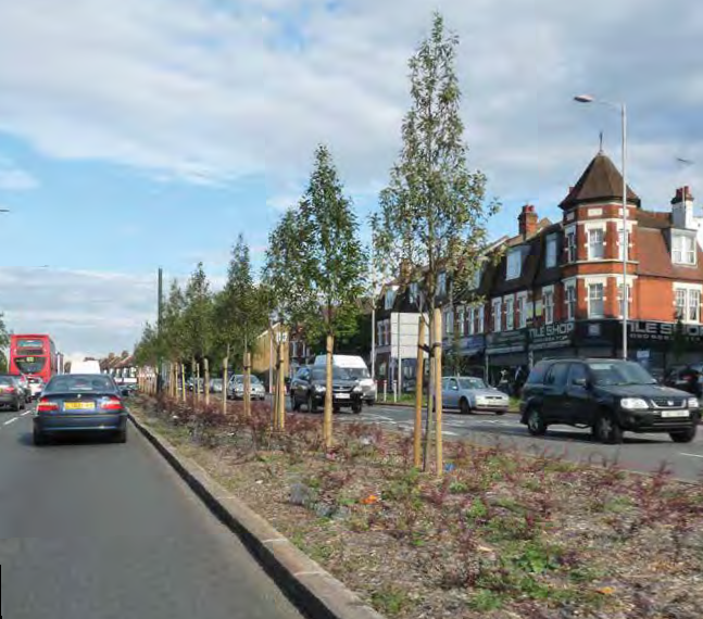
Landscape improvements delivered as part of TfL's Safety and Environment Scheme
The development of back gardens and backland areas has been raised as an issue during the preparation of the AAP. The Council’s position on back garden and backland development is set out in DMD Policy 7: Development of Garden Land which makes clear the Council’s presumption against new residential development on garden land.
An exception to this policy is the land between the southern boundary of Broomfield Secondary School and Bowes Road. Garages were previously accessed along an informal lane but in view of the character of the local area and the relationship between the site and the secondary school, development of mews-style housing at the back of this site is considered to meet the criteria under DMD Policy 7.
Transport for London’s safety and environment scheme along the North Circular Road has delivered improved facilities for pedestrians, cyclists, and introduced bus priority measures. Improvements for pedestrians have included a range of new and improved pedestrian crossings including new at-grade crossings replacing an old footbridge near the Pymmes Road allotments and the provision of a new footbridge in addition to replacement pedestrian crossings at the junction between Bowes Road and Telford Road. The improvements have also introduced new vehicular lanes along this busy section of road which, combined with improvements to major junctions, has helped increase road capacity and reduce congestion.
NC POLICY 8 TRANSPORT AND MOVEMENT IN THE NCAAP AREA
The Council will continue to work closely with Transport for London on assessing the efficiency of the strategic road network in the area and the traffic impact of the A406 on the immediate and nearby secondary road network. With the recent Safety and Environment scheme now successfully implemented, no further major works are planned for this part of the strategic road network. The Council will, however, assist in the preparation of the Major of London Roads Task Force's forthcoming Road Strategy. In so doing and alongside Transport for London, the Council will consider how further improvements to the network can be delivered as opportunities to do so arise.
The Enfield Plan promotes borough-wide transport improvements with a focus on the road network, pedestrians and cycling, and public transport. In particular, Core Policy 24 requires that any improvements to the North Circular Road contribute towards ‘Enfield’s economic regeneration and development, support businesses, improve safety and environmental quality, reduce congestion, and provide additional capacity where needed.' Whilst improvements to the road network will continue to be sought and discussions will continue with Transport for London, it is considered no longer necessary to continue to carry forward the historic local safeguarding of land as illustrated in the adopted Core Strategy Proposal Map. Following adoption of the NCAAP, any subsequent Local Plan policies map should not continue this designation.
Core Policy 25 directly addresses the issue of public realm improvements and how these should help to improve quality and safety for pedestrians and cyclists. This Policy promotes the prioritisation of schemes that reconnect the borough’s communities to services, facilities and each other. In Core Policy 26, better wayfinding and integration between modes is identified as a required improvement at New Southgate rail station.
DMD Policy 48: Transport Assessments sets out the Council’s approach towards assessing the transport impact of new proposals. All applicable developments within the NCAAP area would be required to submit a Transport Assessment, and possibly a site- or occupier-specific Travel Plan. This would help to demonstrate how new developments would achieve the aims of policies within The Enfield Plan.
Policy 45: Parking Standards and Layouts of the DMD sets out the Council’s approach towards the provision of car parking at new developments. It states that the Council will generally have regard to the London Plan’s maximum car parking standards and lists the types of development that might qualify for a limited level of car parking, or be acceptable as a car free form of development.
The Mayor’s Transport Strategy is also relevant to the NCAAP, particularly given the strategic road network issues of direct relevance to the area. The Strategy confirms that the Mayor’s broad approach to managing road congestion is the ‘smoothing’ of traffic flow.
Benefitting from the station stops on the northern extents of the Piccadilly Line and the bus services that support them, the AAP area is one of the more accessible areas in the borough. The area arcing between Bounds Green and Arnos Grove is the most accessible given the combination of tube and bus services in the area. This area, which incorporates the Arnos Grove and Bowes Road local centres, has a PTAL rating of 4. The immediate vicinity of the junction between Bowes Road and Green Lanes also benefits from the PTAL rating of 4.
Arnos Grove station has commuter parking either side of the station building. These sites are identified for potential redevelopment sites. These sites are owned by TfL and their suitability for redevelopment will depend on their role in providing commuter parking on this location.
Air quality
Enfield borough as a whole has been declared an Air Quality Management Area. The latest data from Enfield’s monitoring station along the A406 shows that the area suffers from air quality issues.
The New River Path, looking north towards Palmers Green

NC POLICY 9 ENVIRONMENTAL MITIGATION - AIR QUALITY AND NOISE POLLUTION
New buildings should address the North Circular Road with windows and doors facing and accessed directly from this main road. The internal planning of new development should position living and sleeping accommodation away from the most polluted side of the development. Housing design should encourage natural ventilation so that cleaner air is drawn into buildings from less polluted sides of the development. Landscape and biodiversity proposals will also play an important role in the mitigation of pollution.
Core Policy 32 outlines the Council’s position on pollution and confirms that the Council will require new development to improve air quality by reducing pollutant emissions and public exposure to pollution. Criteria for assessing proposals in this regard are outlined under DMD Policy 65: Air Quality. This policy confirms that the Council expects new developments to be at least ‘air quality neutral’.
The Council has limited control over air quality, although the issue will be an important material consideration in the determination of planning applications. The design of new development and their associated landscaping proposals can significantly help in the mitigation of environmental problems such as air and noise pollution. It is important to ensure the A406 is seen and perceived to be an integral part of the public realm. It should be a route that is used by pedestrians, cyclists, bus users and motorists alike. Having new buildings that address the road with windows and doors accessed directly from it is therefore important. The internal planning of new development can then help mitigate against air and noise pollution by positioning rooms appropriately.
Open space
The policy framework relating to green infrastructure and open spaces is outlined under Core Policy 34 together with policies 71-81 in the DMD.
NC POLICY 10 OPEN SPACES, WATERWAYS AND THE BLUE RIBBON NETWORK
New development should make appropriate contributions to improving the quality of the existing open space network across the NCAAP area. Opportunities to improve the network of spaces alongside the area's waterways are a priority in this regard.
The Bowes area is identified as being deficient in open space, with much of the south western part of the NCAAP area falling beyond an 800m catchment area of any recognised open space. DMD Policy 72: Open Space Provision, makes clear that where proposed development is located in areas deficient in either quantity or access to public park provision it will be necessary for the applicant to make a contribution towards the enhancement of the quality of open space provision including the range of facilities and its condition.
The urban analysis in Section 4 of the NCAAP identifies the principal open spaces in the NCAAP area, and specifically the open spaces within each of the 3 identified neighbourhood places. The waterways, some of which benefit from towpaths and public routes, are both a major asset in the local area and present significant opportunities for improvement. Collaboration with the Council and other agencies including The Canal and River Trust will be important in delivering any such improvements.
Biodiversity
Enfield has a Biodiversity Action Plan, which was adopted in September 2011. This sets out how the borough’s biodiversity assets will be managed, and specifically seeks biodiversity enhancements through the NCAAP. Core Policy 36 supports proposals that will contribute towards the aims of the Biodiversity Action Plan.
The Council’s expectations for how individual new developments should contribute towards biodiversity improvements are set out within DMD Policies 78 and 79. All proposals within the NCAAP area should comply with these requirements.
The New River alongside Russel Road

Climate Change and Renewable Energy
Core Policy 36 sets out the Council’s requirements for new development proposals in terms of impact on climate change. In accordance with these requirements, development within the NCAAP area should minimise energy use and, where possible, use and contribute towards the production of energy generated from renewable sources. Developments should also accord with DMD policies 49-58, which set energy efficiency standards and the Council’s requirements for how these should be achieved.
In particular, it should be noted that the Council published a Renewable Energy and Low Carbon Development Study in March 2010. This identifies large parts of the NCAAP area as potentially suitable for district heating, using combined heat and power. The proposed redevelopment of the Ladderswood Estate and Western Gateway sites, especially, could deliver district heating networks that might also connect to other development sites and existing buildings. DMD Policy 52: Decentralised Energy Networks, sets out a framework for the assessment of district heating proposals and other decentralised energy networks.
The Council is committed to further exploring the potential for a district heating network in the NCAAP area. There is already sufficient heat density to make the use of district heating viable and this will be increased significantly as a result of the redevelopment proposals in the area.
Flooding - Surface Water Flooding from work undertaken for Drain London 2011
There are some small areas of significant flood risk within the NCAAP area, as shown in Enfield’s 2008 Strategic Flood Risk Assessment and associated 2010 High-Level Sequential Test Assessment of strategic sites. Core Policy 28: Managing Flood Risk Through Development generally seeks the direction of new development towards areas of low flood risk and DMD Policies 59 and 60 provide more detail in this respect.
DMD Policy 61: Managing Surface Water requires that all new developments incorporate Sustainable Urban Drainage. This will help to contribute toward the fulfilment of the Drain London project aims, which are focused around reducing the risk of flooding from surface water.
< Previous | ^ Top | Next >