
In addition to the documents listed in Appendix 4 of the Core Strategy, the following documents and studies have informed the Development Management Document (DMD).
National Planning Policy
Regional plans and policies
All London Green Grid Supplementary Planning Guidance (GLA) (2012)
Mayor's Supplementary Planning Guidance on Shaping Neighbourhoods: Play and Informal Recreation (GLA) (2012)
Local plans and policies
Local Studies
Table 1.1
Project |
Objectives |
Areas of Archaeological Importance Review (2012) |
Identifies and recommends proposed changes to Areas of Archaeological Importance |
Employment Land Review (2012) |
Review market demand for designated employment sites. Provide up to date evidence to justify protection of employment sites. |
Enfield Characterisation Study (2011) |
To describe the form, character and special attributes of Enfield borough. |
Areas of Special Character Review (2012) |
Identifies and recommends proposed changes to Areas of Special Character. |
Town Centre Uses and Boundaries Review (2013) |
Set appropriate boundaries for district centres, local centres and shopping parades. |
Surface Water Management Plan (2012) |
Identify areas at risk of surface water flooding. |
Pre-feasibility Study of the Viability of a Decentralised Energy Network in the Context of the Upper Lee Valley (2011) |
Assess feasibility of developing DENs particularly in the Upper Lee Valley. To ensure that networks are secured through the planning application process. |
Enfield Open Space and Sports Assessment Update (2011) |
Inform designation of sites for protection. Establish open space standards for new development including standards for children's play. |
Open Space Policies Map Paper (2013) |
Report details of new open space sites, changes to existing boundaries and deletion of existing open spaces. |
Metropolitan Open Land and Green Chain Associated Open Space Review (2013) |
Create robust and defensible boundaries to protect MOL and to recommend the designation of Green Chain Associated Open Space as MOL where they meet the GLA criteria. |
Review of Enfield's Sites of Local and Borough Importance for Nature Conservation (2013) |
Designate sites for protection according to approved criteria. |
Enfield's Detailed Green Belt Boundary Review (2013) |
Create robust and defensible boundaries to protect the Green Belt. |
Report on Location of Tall Buildings and Important Local Views in Enfield (2013) |
Identify appropriate; inappropriate and sensitive sites for tall buildings and important local views for use in decision making. |
Community Infrastructure Levy and Development Management Document Viability Assessment (2013) |
To ensure that costs involved in complying with DMD policies in the setting of CIL charges do not make developments unviable. |
Table 2.1 Relationship of DMD Policies and Saved Unitary Development Plan (UDP) (1994) Policies
UDP POLICY |
|
LOCAL PLAN POLICY DOCUMENTS |
|||||
UDP Policy No . (excludes policies expired Sept 07) |
Policy Title |
Is the UDP Policy superseded by a DPD Or Expired. |
Core Strategy DPD |
Development anagement DPD |
Area
|
Sites Schedule DPD |
Enfield Design Guide ' |
(I) E01 |
Equal Opportunities |
Y |
9 1 |
Development Management Document has been subject to an Equalities Impact Assessment |
|
|
|
(I) N1-N4 |
Borough Structure |
Y |
|
|
|
|
|
(I)EN1-EN6 |
General Environmental Considerations |
Y |
28-36 |
37, 38, 43, 44, 49, |
|
|
|
(II)EN3-EN5 |
Advertisements |
Y |
33 |
41 |
|
|
Y |
(II) EN6 |
Telecommunications |
Expired |
|
Not replaced |
|
|
|
(II) EN10-EN15 |
Nature Conservation |
Y |
36 |
76, 78, 79 |
|
|
|
(II) EN16 |
Article 4 Directions |
Expired |
Not replaced |
|
|
|
|
(II) EN17-EN18 |
Environmental |
Y |
29 |
50 |
|
|
|
(II) EN20-EN21 |
Vacant and Under-Used Land |
Expired |
Not replaced |
|
|
|
|
(II) EN23 |
Environmental Education |
Expired |
|
Not replaced |
|
|
|
(II) EN24-EN26 |
Minerals |
Y |
23 |
|
|
|
|
(II) EN29 |
Waste |
Y |
21, 22 |
49, 57 |
|
|
|
(II) EN30-EN32 |
Pollution |
Y |
32 |
64, 65, 66, 67, 68, |
|
|
|
(I) G1-G3 |
Green Belt |
Y |
33 |
82 |
|
|
|
(II) G1-G5 |
Environmental Measures / Management |
Y |
33 |
82, 88 |
|
|
|
(II) G6 |
Areas of Special Character |
Y |
33 |
84 |
|
|
|
(II) G7-G10 |
Landscape Measures |
Y |
31 |
78, 80, 81, 82 |
|
|
Y |
(II) G11-G19 |
Environmental Measures Affecting New Development |
Y |
28, 29 |
81, 82 |
|
|
|
(II) G20-G21 |
Urban Edge |
Y |
33 |
83 |
|
|
|
(II) G22 & G24 |
Agriculture |
Y |
|
85, 86 |
|
|
|
(II) G25 |
Horticulture |
Expired |
|
Not replaced |
|
|
|
(II) G26 |
Garden Centres |
Expired |
|
Not replaced |
|
|
|
(II) G27-G28 |
Horsekeeping |
Y |
|
87 |
|
|
|
(II) G29-G30 |
Lee Valley Regional Park |
Y |
33, 35 |
89 |
|
|
|
(II) G31-G33 |
Recreation |
Y |
11, 34 |
87 |
|
|
|
(II) G34-G39 |
Residential Development |
Y |
|
90 |
|
|
|
(II) G40-G41 |
Horticulture / Garden Centres |
Y |
|
90, 91 |
|
|
|
(II) G42 |
Livestock Units |
Y |
|
90 |
|
|
|
(II) G43 |
Horsekeeping |
Y |
|
87 |
|
|
|
(II) G44-G45 |
Landscape Treatment |
Y |
|
91 |
|
|
|
(I)01, 02 & 04 |
Open Space & Metropolitan Open Land |
Y |
34 |
71 |
|
|
|
(1) 03 |
Green Chains |
Y |
34 |
77 |
|
|
|
(II)01-05 |
Metropolitan Open Land |
Y |
34 |
71 |
|
|
|
(II) 06-09 |
Green Chains |
Y |
34 |
77 |
|
|
|
(II) 010-018 |
Urban Open Space |
Y |
34 |
71, 72,73 |
|
|
|
(II) 019 |
Playing Fields |
Y |
34 |
74 |
|
|
|
(II) 020 |
Leisure Gardens (Allotments) |
Y |
34 |
85 |
|
|
|
(I)C1 |
Conservation and Townscape |
Y |
31 |
44, 84 |
|
|
|
(II)C1-C7 |
Archaeology and Ancient Monuments |
Y |
31 |
44, 84 |
|
|
|
(II) C8-C11 |
Procedures |
Expired |
Not replaced |
|
|
|
|
(II) C12-C14 |
Protection and Maintenance of Listed Buildings |
Y |
31 |
44 |
|
|
Y |
(II) C16-C17 |
Use of Listed Buildings |
Y |
31 |
44 |
|
|
|
(II) C18-C20 |
Historic Landscapes |
Y |
31 |
44, 84 |
|
|
Y |
(II) C21 |
Designation of Conservation Areas |
Y |
31 |
|
|
|
|
(II) C23-C25 |
Safeguarding the Environment in Conservation Areas |
Y |
31 |
|
|
|
|
(II) C26-C31 |
Quality of Development |
Y |
30, 31 |
44 |
|
|
|
(II) C32-C34 |
Advertisements |
Y |
|
41 |
|
|
|
(II) C35-39 |
Tree Protection |
Y |
|
80 |
|
|
|
(I)GD1-GD2 |
General Development Considerations |
Y |
30 6 |
37 |
|
|
|
(II)GD1 |
Land Use Compatibility |
Expired |
Not replaced |
|
|
|
|
(II) GD3 - GD9 |
Planning Standards |
Y |
|
37, 38, 39, 40, 42, |
|
|
|
(II) GD 10 |
Integration of Development |
Y |
30 |
37 |
|
|
|
(II) GD12-GD13 |
Flooding and Surface Water Drainage |
Y |
28, 29 |
59, 60, 61, 62, 63 |
|
|
|
(I)H2-H4 |
Housing |
Y |
2 - 6 |
1, 2, 4, 5, 15 |
|
|
|
(II)H2-H4 |
Housing - The Existing Housing Stock |
Y |
4-6 |
4, 5, 30 |
|
|
|
(II) H5-H6 |
Housing - The Existing Housing Stock |
Y |
5-6 |
1, 2, 3, 4, 5 |
|
|
|
(II) H8-H15 |
Standards of Residential Development - General Standards of Residential Development |
Y |
|
8, 9, 10, 11, 13, 14 |
|
|
|
(II) H16 |
Standards of Residential Development - Conversions |
Y |
|
5 |
|
|
Y |
(II) H18 |
Standards of Residential Development - Housing Needs of People with Disabilities |
Y |
6 |
15 |
|
|
|
(II) H2O |
Housing Support Services - Accommodation for Homeless Persons |
Y |
|
15 |
|
|
|
(II) H22 |
Housing Support Services - Special Needs |
Y |
6 |
15 |
|
|
|
(I)E1-E4 |
Employment and Economic Development |
Y |
13, 14, 15, 16, |
19, 20, 22, 23, 24, |
|
|
|
(II)El |
Availability of Land and Labour |
Y |
13, 14, 15, 19 |
19, 20, 22, 23, 24 |
|
|
|
(II) E2-E3 |
Commercial and Industrial Defined Areas |
Y |
14,19 |
19,26 |
|
|
|
(II) E4 |
Special Needs of Small Firms |
Y |
15 |
24 |
|
|
|
(II) E5-E7 |
Secondary Industrial Premises |
Y |
14, 15 |
19 ,20 |
|
|
|
(II) E9 |
Non-Commercial and Industrial Uses |
Y |
14 |
21 |
|
|
|
(II) Ell |
Standards of Development |
Y |
|
39 |
|
|
|
(II) E12 |
Infrastructure |
Expired |
|
Not replaced |
|
|
|
-1.10E+15 |
Infrastructure |
Y |
|
23 |
|
|
|
(II) E14-E15 |
Environmental Safeguards |
Y |
|
64, 68 |
Y |
|
|
(I)S1-53 |
Shopping and Town Centres |
Y |
17 |
25, 26, 27, 28 |
|
|
|
(II)S1 |
Town Centres |
Y |
17 |
26 |
|
|
|
(II) S2 |
Town Centres |
Y |
17 |
27 |
|
|
|
(II) S3 |
Management of the Town Centres |
Y |
17, 18 |
25, 26, 27, 28, 30, |
Y |
|
|
(II) S5-S11 |
Non-Retail Uses in Town Centres |
Y |
17, 18 |
25, 26, 27, 28 |
|
|
|
(II) S13-S15 |
Local Centres |
Y |
17, 18 |
28, 29 |
|
|
|
(II) S17 |
Major Out-of-Centre Retail Development |
Y |
|
25 |
|
|
|
(11) S18 |
Food and Drink |
Y |
|
32 |
|
|
|
(II) S19 |
Design Considerations |
Y |
30 |
40, 41 |
|
|
Y |
(II) S20-S21 |
Accommodation on Upper Floors |
Y |
|
30 |
|
|
|
(II) S22 |
Access for People with Disabilities |
Y |
|
37 |
|
|
|
(I) T1-T11 |
Transportation |
Y |
24 - 27 |
45, 46, 47, 48, 49, |
|
|
|
(II)T1 |
Land Use and |
Y |
|
8 |
|
|
|
(II) T3-T5 |
Public Transport |
Y |
26 |
|
|
|
|
(II) T6-T7 |
Roads - Highway Network |
Y |
24 |
|
|
|
|
(II) T8-T12 |
Roads - Environmental Considerations |
Y |
24-27 |
|
|
|
|
(II) T13 |
Roads - Highway Improvements |
Y |
|
46, 47 |
|
|
|
(II) T14 |
Roads - Highway Improvements |
Y |
46 |
|
|
|
|
(II) T15 -T17 |
Pedestrians |
Y |
25 |
47 |
|
|
|
(II) T19-T21 |
Cycling |
Y |
25 |
45, 47 |
|
|
|
(II) T22-T23 |
Freight - Road Freight |
Y |
27 |
|
|
|
|
(II) T24 |
Freight - Rail |
Y |
27 |
|
|
|
|
(II) T25-T26 |
Freight - Waterways |
Y |
27 |
75 |
Y |
|
|
(II) T27-T32 |
Parking |
Y |
|
45 |
|
|
|
(II) T33 |
Safety |
Y |
9 |
46, 47 |
|
|
|
(I)AR1-AR2 |
Arts, Recreation and Tourism |
Y |
11, 12 |
16, 17 |
|
|
|
(II)AR1& AR3 |
Recreation |
Y |
11 |
16, 17 |
|
|
|
(II) AR4-AR5 |
Arts, Culture and Entertainment |
Y |
11 |
16, 17 |
|
|
|
(II) AR6-AR7 |
Tourism |
Y |
12 |
31 |
|
|
|
(I)CS1 |
Community Services |
Y |
7 - 10 |
16, 17 |
|
|
|
(II)CS1-CS3 |
Land and Environmental Considerations |
Y |
|
16, 17 |
|
Y |
|
(II) CS4 |
Day Nurseries |
Y |
|
18 |
|
|
|
(II) CS5 |
Places of Public Worship |
Y |
|
16, 17 |
|
|
|
(II) ET1 |
Enfield Town - Land Uses |
Y |
17, 18, 42, 43 |
25 |
|
|
|
(II) ET4, ET6, ET7, ET 8 and ET 12. |
Enfield Town - Shopping Developments |
Expired |
17, 18, 42, 43 |
Not replaced |
|
|
|
All development proposals must be accompanied by a Sustainable Design and Construction Statement, the scale and scope of which will be determined on a site-by-site basis and as published in the local validation list upon adoption of this document and in further guidance as set out in the Council’s Local Development Scheme. It will outline how the proposal complies with relevant local, regional and national sustainable design and construction policies and should include as a minimum, information and evidence (where relevant) under the following headings:
A. Energy Statement
The sustainable design and construction statement will be required to include an Energy Statement for all developments to demonstrate how the development has minimised on-site CO2 emissions in accordance with the principles of the energy hierarchy to achieve the requirements of Core Policy 20.
Energy assessments should include the following details:
Separate sections under each of the points will need to take account of unregulated energy uses (as derived from appliances not covered by Building Regulations) and developers will be required to show how, as a result of development energy consumption and consequently carbon emissions have been reduced.
If it can be demonstrated that the achievement of relevant energy targets is not technically feasible or economically viable, the Energy Statement will be required to express the shortfall in tonnes of carbon/year and, in accordance with the formula adopted by the S106 SPD, a calculation of the cost to off-set the remaining carbon over the lifetime of the development (currently set at 30 years).
Where developers are seeking to off-set an identified shortfall through near-site enhancement options, including refurbishment of existing properties, the Energy Statement must contain clear calculations of the amount of carbon that is saved as a result of works. This figure must be equal to or greater than the shortfall and relevant legal agreements with relevant parties will form the basis of a S106 agreement to secure the works.
For further guidance please refer to the GLA's guidance on preparing energy assessments at http://www.london.gov.uk/priorities/planning/strategic-planning-applications/pre-planning-application-meeting-service/energy-assessments.
B. Water Efficiency
In accordance with DMD 58, the Sustainable Design and Construction Statement should include a section examining water efficiency within the development to meet relevant targets specified by the Policy. It should also provide details of the maximum level of water that can feasibly be provided to the development from rainwater and, where possible, grey water recycling, and include proposals for the integration of such systems into the development.
All new development proposals will be required to demonstrate that there is sufficient water supply infrastructure capacity both on and off site to serve the development or that any necessary upgrades will be delivered ahead of the occupation of development.
Relevant calculator tools utilised by the Code for Sustainable Homes and BREEAM can be used to qualify the statements and may form the basis of a condition attached to any planning consent.
C. Design
Linked to DMD 37 'Achieving High Quality and Design-Led Development', DMD 49 'Sustainable Design and Construction Statements', DMD 51 'Energy Efficiency Standards', DMD 53 'Low and Zero Carbon Technology', DMD 55 'Use of Roof Space/ Vertical Surfaces', DMD 56 'Heating and Cooling', DMD 59 'Avoiding and Reducing Flood Risk', DMD 61 'Managing Surface Water' and DMD 62 'Flood Control and Mitigation Measures'this section of the statement should demonstrate how sustainable design and construction best practice has influenced the form, bulk, mass and layout of the scheme to adapt to climate change and maximise efficiencies including:
Where appropriate and consistent with DMD 8 'General Standards for New Residential Development' a daylighting study may also need to feature within the sustainable design and construction statement.
D. Waste Management and Construction
Details of fully accessible waste and recycling storage will be required for all applications (excluding householder) in accordance with the London Borough of Enfield's: Waste a Recycling Planning Storage Guidance ENV 08/162 or replacement document. In addition developments will be required to demonstrate compliance with WAS1 of the Code for Sustainable Homes (in the case of residential development) and WST 03 of BREEAM or equivalent.
A Site Waste Management Plan will be required for all Major developments (and those defined under the Clean Neighbourhoods and Environment Act 2005) to accord with the requirements of Policy 5.18 of the London Plan and demonstrate procedures for the minimisation of construction waste consistent with the principles of the waste hierarchy: reduce; reuse; recycle; recover.
As a minimum SWMPs should include:
A. Target benchmarks for resource efficiency set in accordance with best practice.
B. Procedures and commitments to minimise non-hazardous construction waste at design stage. Specify waste minimisation actions relating to at least 3 waste groups and support them by appropriate monitoring of waste.
C. Procedures for minimising hazardous waste.
D. Monitoring, measuring and reporting of hazardous and non-hazardous site waste production according to the defined waste groups (according to the waste streams generated by the scope of the works)
E. Diversion of waste from landfill should adhere strictly to the principles of the waste hierarchy of reduce; reuse; recycle; recover and evidence demonstrating each tier has been exhausted before a subsequent tier is employed according to the defined waste groups (in line with waste streams generated by the scope of the works). In additional a minimum of 85% of non-hazardous site construction waste by volume or weight must be diverted from landfill.
All other developments will be required to demonstrate through their statements how construction and demolition waste has been minimised so far as practicable and commensurate with the scale and scope of the scheme.
The statement should include details of how construction site impacts have been minimised to prevent undue disruption to the surrounding areas, prevention of air and water pollution, and that all reasonable measures have been introduced to reduce energy and water consumption in accordance with the requirements of MAN2 of the Code for Sustainable Homes (for residential development) and MAN 03 of BREEAM (for non-residential development) or equivalent.
E. Materials and Green Procurement
DMD 57 'Responsible Sourcing of Materials, Waste Minimisation and Green Procurement' requires major development to submit a Green Procurement and Construction Plan. This should demonstrate how the procurement of materials for the development will promote sustainability, including by use of low impact, locally and/or sustainably sourced, reused and recycled materials. The Plan should also include strategies to secure local procurement and employment opportunities. Wherever possible, this should include targets and a process for the implementation of this plan through the development process.
In addition, all other forms of development will be required to submit a statement and relevant evidence to demonstrate that all materials used have been responsibly sourced and their embodied energy minimised. Relevant calculator tools under the Code for Sustainable Homes and BREEAM may be submitted with the scheme as well as excerpts from the 'Green Guide to Specification' at http://www.bre.co.uk/greenguide/podpage.jsp?id=2126. Where applicable the reuse of existing structures will be encouraged.
Strategies to secure local procurement and employment opportunities are likely to feature as one of the Heads of Terms of a s106 agreement accompanying any consent.
F. Health and Wellbeing:
The statement should contain details outlining how the development has been designed for flexible use and adaptation to reflect changing lifestyles and needs of the end user including:
Adequate daylighting (DMD 8 'General Standards for New Residential Development');
Access to amenity space (DMD 9 'Amenity Space');
Access to recreation and play facilities (DMD 71 'Protection and Enhancement of Open Space', DMD 72 'Open Space Provision', DMD 74 'Playing Pitches' & DMD 73 'Children’s Play Space');
Provision of community services;
Consistent with DMD 37 'Achieving High Quality and Design-Led Development' demonstrating that the development is flexible enough to respond to social, technological and economic change;
Provision of home office facilities;
Evidence demonstrating compliance with the principles of Lifetime Homes a through each of the 16 criterion implementing best practice were feasible;
Adherence to DMD 15 'Specialist Housing Needs' demonstrating where necessary how the development has been design to accommodate specialist needs, including wheelchair accessibility;
Submission of a Health Impact Assessment consistent with Policy 3.2 of the London Plan where appropriate;
Provision for food growing space/allotments; and,
Where appropriate, assessment under BREEAM Communities.
The statement should make explicit reference to Policies in the Local Plan, Enfield's Sustainability Programme, the Sustainable Communities Strategy and the objectives contained within Enfield's Food Strategy.
G. Surface Water Run-off and Flood Risk:
In accordance with DMD 59 'Avoiding and Reducing Flood Risk', DMD 60 'Assessing Flood Risk', DMD 61 'Managing Surface Water', DMD 62 'Flood Control and Mitigation Measures' & DMD 63 'Protection and Improvement of Watercourses and Flood Defences' this section of the statement should evidence how surface water run-off has been attenuated from pre- to post construction, including details of Sustainable Drainage Systems proposed, any rain water harvesting installations,the sustainable drainage strategy, and where appropriate flood risk assessments.
As part of the Sustainable Drainage Strategy, developers will also be required to demonstrate that there is sufficient wastewater infrastructure both on and off site to serve the development.
Proposals in areas susceptible to flooding will be required to include flood resistant and/or resilient measures to mitigate potential flood risks in accordance with DMD 59 'Avoiding and Reducing Flood Risk', DMD 61 'Managing Surface Water', DMD 62 'Flood Control and Mitigation Measures' & DMD 63 'Protection and Improvement of Watercourses and Flood Defences'.
H. Ecology and Green Infrastructure:
In accordance with DMD 75 'Waterways', DMD 76 'Wildlife Corridors', DMD 77 'Green Chains', DMD 78 'Nature Conservation', DMD 79 'Ecological Enhancements', DMD 80 'Trees on Development Sites' & DMD 81 'Landscaping' the proposal will be required to outline how the development will contribute to the protection, enhancement or restoration of the ecological value of the site and, if appropriate the surrounding area, including the provision of living roofs and landscaping/design features as well as contributing to the formation and enhancement of waterways, wildlife corridors and green chains 8 9 10 11
I. Travel:
Evidence should be provided to demonstrate how the development has sought to minimise traffic generation and the need to travel by car/private motor vehicle in accordance with DMD 47 'Access, New Roads and Servicing'. In accordance with Policy 6.13 of the London Plan the location, number and type of electric charging points (both active and passive) must be evidenced and qualified by this accompanying statement. Where appropriate Transport Assessments and Travel Plans should accompany the statement.
J. Pre-assessments:
All new residential developments and all major non-residential developments must submit detailed pre-assessment under the Code for Sustainable Homes or the relevant BREEAM scheme undertaken by a BRE qualified and licensed assessor, these will form Appendices to the Sustainable Design and Construction Statement.
Other documents that may form part of the Sustainable Design and Construction Statement include, but are not limited to:
The requirement for these documents will be triggered by the Local Validation List.
Outline Applications
Outline planning applications need to fully address and commit to sustainable design and construction measure including energy efficiency. Depending on the matters to be considered, applicants should still undertake initial feasibility work on all the aspects set out above. The energy statement, in particular should address a site-wide energy strategy to form the framework of consideration for reserved matters applications. The structure should be the same as set out for full planning applications. Based on this information the Local Planning Authority will secure conditions to ensure that reserved matters applications contain an sustainable design and construction strategy that demonstrates consistency with the outline document submitted and energy strategy.
Existing Buildings
The Council recognises the importance of improving the energy performance of the existing building stock and proposals involving refurbishment, fit out, conversion, or the change of use of an existing building that do not qualify for an assessment listed nder DMD 51 'Energy Efficiency Standards'will be encouraged to achieve high standards of energy and water efficiency, and should seek to exceed relevant Building Regulations wherever possible with a baseline requirement for development to achieve an Energy Efficiency Rating (EER) or Energy Performance Asset Rating (EPAR) of 65 or an 8% improvement (whichever provides the greatest improvement over relevant Building Regulations).
Planning applications for changes to existing domestic and non-domestic units will need to be accompanied by a completed ‘sustainable design and construction statement’ to identify if there are any reasonable improvements that could be made to the performance of the existing unit. Where measures are identified these will be enforced via condition in any approvals.
For domestic applications improvements will include, but will not be restricted to:
Opportunities for micro-generation of renewable energy through retrofitting will be supported, where appropriate in accordance with DMD 53 'Low and Zero Carbon Technology'.
Proposals in areas susceptible to flooding will be required to include flood resistant and/or resilient measures to mitigate potential flood risks in accordance with DMD 59 'Avoiding and Reducing Flood Risk', DMD 61 'Managing Surface Water', DMD 62 'Flood Control and Mitigation Measures' & DMD 63 'Protection and Improvement of Watercourses and Flood Defences'.
Additional energy targets will be required for major residential and non-residential applications involving refurbishment, fit out, conversion, or the change of use of an existing building based on the BREEAM minimum standards for energy efficiency in accordance with the targets set by DMD 50 'Environmental Assessment Methods'. Further energy efficiency standards will be considered and published following review of current Policy or as part of subsequent SPD.
Viability
Where a scheme seeks to demonstrate the exceptional circumstances for non-conformity with a Sustainable Design and Construction Policy through either technical feasibility or economic viability, this will need to be clearly evidenced through the Sustainable Design and Construction Statement accompanying the scheme. The assessment of economic viability shall feature under any of the relevant headings or form a stand-alone section within the statement and will provide more detailed and technical information that builds on the relevant viability toolkit submitted with the application and clearly outlines the exceptional costs associated with the requirement. Alternative or potentially mitigating scenarios will need to be fully explored and justified. The merits of the viability testing will be scrutinised and if necessary negotiated upon based on the Council's own evidence.
Minimum Space Standards
The following minimum space standards will be applied in line with the London Plan (2011) and/or the London Housing Design Guide:
Table 4.1
|
Dwelling type (bedroom (b)/persons-bedspaces(p)) |
GIA (sq m) |
Flats |
1p |
37 |
|
1b2p |
50 |
|
2b3p |
61 |
|
2b4p |
70 |
|
3b4p |
74 |
|
3b5p |
86 |
|
3b6p |
95 |
|
4b5p |
90 |
|
4b6p |
99 |
2 storey houses |
2b4p |
83 |
|
3b4p |
87 |
|
3b5p |
96 |
|
4b5p |
100 |
|
4b6p |
107 |
3 storey houses |
3b5p |
102 |
|
4b5p |
106 |
|
4b6p |
113 |
For dwellings designed for more than 6 people, at least 10 sq m gross internal area should be added to the minimum standard for 6 person accommodation for each additional person. For the purposes of this document, studio flats are defined as accommodation usually consisting of a continuous/non compartmentalised space (for sleeping and living in), a bathroom and sometimes a separate kitchen.
For residential units within the roof space, the space within the eaves can provide the opportunity for storage space. Where these are allocated and appropriate for storage, these areas may be counted and therefore deducted from the storage space requirements specified in the London Housing Design Guide.
Dwelling functionality
When assessing part e) of the above policy, the Council will particularly consider the following:
Daylight and sunlight
New residential buildings should be designed, in terms of their layout and orientation, to take advantage of daylight/sunlight to allow for passive heating and cooling and the use of micro generation technology. This may not be possible for extensions to existing properties or infill development which need to have regard to the existing building lines along the street. Appropriate levels of daylight/sunlight for new development will be assessed in accordance with minimum standards in the Code for Sustainable Homes technical guidance and the London Housing Design Guide. Daylighting/sunlighting studies should demonstrate that developments are designed to maximise the use of natural light.
Disturbance
When assessing the potential for disturbance, the Council will consider whether:
The commercial uses covered by this appendix are for A3 (restaurants and cafes) A4 (drinking establishments), A5 (hot food takeaway), banqueting suites (DMD Policy 35) and social clubs (DMD Policy 36).
The permitted opening hours of premises as set out in this appendix should be considered along with national licensing regulations and Enfield Council Licensing Policies.
This appendix sets out the opening hours according to the hierarchy of town centres.
The potential disturbance caused by an A3/A4/A5, banqueting suite or social club use, particularly in the evenings, arises in the main from:
Opening and Closing Times
In order to address such matters, the Council can impose a restriction on the days and times when the A3/A4/A5, banqueting suite or social club premises may be open for business. In this regard, the Council employs the following terms:
It should be noted that the term "closing time" does not mean the time at which the doors are closed to any further customers, or the time at which last orders may be taken.
The Council recognises that operators of A3/A4/A5, banqueting suite or social club establishments will normally wish to tidy up both the dining area and kitchens after the customers have left. In attaching an "hours of use" condition to a planning application, therefore, the Council may also specify the period immediately following the closing time during which the operator may carry out any cleaning, tidying, laying the tables for the following day and other such activity related to the use.
Noise and Disturbance
Most A3/A4/A5, banqueting suite or social club uses are located in shopping centres which range in size from large town centres to small local parades and comer shops. In general, the smaller the shopping centre, the more likely it is that surrounding residential areas will be adversely affected by the noise and disturbance generated by an A3/A4/A5, banqueting suite or social club use. On this basis the Council specifies in Tables 17.1 to 17.3 the opening and closing times for A3/A4/A5, banqueting suite or social club uses located in particular types of shopping centre. The Enfield’s hierarchy of town centres is shown on table 6.3 of the Core Strategy.
It is the Council's intention to apply the opening and closing times specified in Tables17.1 to 17.3 as a starting point against which the detailed circumstances of the premises and their surroundings may be assessed. The Council recognises that the individual circumstances affecting the location of an A3/A4/A5, banqueting suite or social club use will vary a great deal. In some circumstances it may be appropriate to make the opening or closing time more restrictive than that specified in Tables 17.1 to 17.3. There may also be circumstances where an earlier opening time or later closing time than that specified would be acceptable.
The factors which the Council takes into account in assessing these matters include:
Traffic-Related Issues
In the case of opening times, the choice of time will be particularly influenced by the level of traffic and by the availability of parking in the vicinity of the A3/A4/A5 banqueting suite or social club premises. Where the on-street parking generated by the premises is, in the Council's opinion, likely to give rise to hazardous conditions or cause congestion, the opening time will be set so as to avoid the premises being open during periods of peak traffic flow. This will be particularly relevant in the case of hot food takeaways or where a takeaway service is to be provided ancillary to the main use.
Opening Hours
The following table is for determining planning applications for the establishment or change of use of premises to use class A3/A4/A5; the days of the week and hours of the day during which those premises located within specific categories of shopping centre maybe open for business.
Table 5.1
Shopping Centres |
Days/Hours During Which the Premises may be Open for Business |
||
Category |
Days |
Opening Time |
Closing Time |
Major Town Centre and District Centres |
Mon — Sat |
08:00 |
02:00 |
Large Local Centres |
Mon — Sat |
08:00 |
00:00 |
Small Local Centres |
Mon — Sat |
08:00 |
23:30 |
Local Parades |
Mon — Sat only |
08:00 |
23:00 |
Outside Town Centres |
Mon — Sat |
08:00 |
23:00 |
The following table is for determining planning applications for the establishment or change of use of premises to banqueting suites; the days of the week and hours of the day during which those premises located within specific categories of shopping centre maybe open for business.
Shopping Centres |
Days/Hours During Which the Banqueting Suite Premises may be Open for |
||
Category |
Days |
Opening Time |
Closing Time |
Major Town Centre and District Centres |
Mon — Sat |
08:00 |
02:00 |
Large Local Centres |
Mon — Sat |
08:00 |
00:00 |
Small Local Centres |
Mon — Sat |
08:00 |
23:30 |
Local Parades |
Mon — Sat only |
08:00 |
23:00 |
Retail Parks |
Mon — Sat |
08:00 |
02:00 |
The following table is for determining planning applications for the establishment or change of use of premises to social clubs; the days of the week and hours of the day during which those premises located within specific categories of shopping centre maybe open for business.
Shopping Centres |
Days/Hours During Which the Social Club Premises may be Open for Business |
||
Category |
Days |
Opening Time |
Closing Time |
Major Town Centre and District Centres |
Mon — Sat |
10:00 |
01:00 |
Large Local Centres |
Mon — Sat |
10:00 |
00:00 |
Small Local Centres |
Mon — Sat |
10:00 |
23:30 |
Local Parades |
Mon — Sat only |
10:00 |
23:00 |
Outside Town Centres |
Not permitted |
Not permitted |
Not Permitted |
Notes:
Requirements of the Heritage Statement
The Heritage Statement may be included within the Design and Access Statement. It must cover the following topics:
1. An assessment of the significance of the asset derived through consultation of the appropriate Historic Environment Record, other records/listings (e.g. statutory and local lists, the Heritage Gateway, the National Monuments Record and local documents such as character appraisals) and on-site assessment of the asset and its setting.
Expert assessment may be necessary depending on the significance of both the asset and the proposed works. Advice should be sought from heritage officers and/or English Heritage regarding the extent of this work;
2. A desk-based assessment of the archaeological interest of a site, where the site is known to include, or is likely to include such interest (e.g. in areas of archaeological importance). Where desk-based research is insufficient to properly assess the interest, a field evaluation (e.g. geophysical survey, physical survey and/or trial trenching) may also be necessary.
3. A reasoned explanation of how the proposal addresses issues raised in character appraisals, management proposals/plans and other relevant evidence-base documents relating to the heritage asset. Development which exacerbates identified issues will be refused and the Council will use its powers to reverse damaging trends where possible. Applicants should visit the Council's website or contact the Heritage Team for the most up-to-date documents relating to the borough’s heritage assets. However, it is useful to note a number of issues that have been consistently highlighted in the evidence base as being of detriment to heritage assets. These include:
4. A reasoned explanation of how the proposal conserves and enhances the heritage asset.
5. Where the proposal will lead to substantial harm to or total loss of significance of the heritage asset, evidence that other potential owners or users of the site have been sought through appropriate marketing and that reasonable endeavours have been made to seek grant funding for the heritage asset’s conservation and to find charitable or public authorities willing to take on the heritage asset.
6. Detail regarding the sources that have been considered and the expertise used in assessing the impact of the proposal.
Applications which fail to adequately address the above will not be acceptable.
Table 7.1 Parking for retail
Maximum standards for retail uses: space per sq m of gross floorspace |
|||
Use |
PTAL 6 and 5 |
PTAL 4 to 2 |
PTAL 1 |
Food |
|
|
|
Up to 500 m2 |
75 |
50-35 |
30 |
Up to 2500 m2 |
45-30 |
30-20 |
18 |
Over 2500 m2 |
38-25 |
25-18 |
15 |
Non food |
60-40 |
50-30 |
30 |
Garden Centre |
65-45 |
45-30 |
25 |
Town Centre/Shopping Mall/Dept Store |
75-50 |
50-35 |
30 |
Table 7.2 Parking for employment uses
Non-operational maximum standards for employment B1: spaces per sq m of gross floorspace |
|
Location |
|
Central London (CAZ) |
1000-1500 |
Inner London |
600-1000 |
Outer London |
100-600 |
Outer London locations identified through DPD where more generous standards should apply |
50-100 |
Table 7.3 Parking for residential development
Maximum residential parking standards |
|||
Number of beds |
4 or more |
3 |
1-2 |
|
2 -1.5 per unit |
1.5 -1 per unit |
Less than 1 per unit |
Notes:
Adequate parking spaces for disabled people must be provided on-site 12
20 per cent of all spaces must be for electric vehicles with an additional 20 per cent passive provision for electric vehicles in the future.
Table 7.4 London Plan Cycle Parking Standards (Minor Alterations November 2011)
Use Class |
1 space per sq.m. of gross floorspace (unless otherwise stated) |
Al - Food |
Out of Centre 1/350 |
Al - Non Food |
Out of Centre 1/500 |
A2 (Financial Services) |
1/125 |
A3 - AS |
1 per 20 staff + 1 per 20 customers |
B1 (Business) |
1/250 |
B2 - B8 (General Industry and Storage & Distribution |
1/500 |
Cl (Hotels) |
1 per 10 staff |
C2 (Residential Institutions) |
1 per 3 staff |
C3 (Dwellings) |
1 per 1 or 2 bed unit |
D1 (Non- residential institutions) Primary, Secondary School University/Colleges |
1 per 10 staff or students |
D2 (Assembly & Leisure) |
1 per 20 staff + 1 per 50 seats |
Cinemas |
1 per 110 staff + 1 per 20 peak period visitors |
Table 7.5
Designated Blue Badge parking bays recommended in BS 8300:2009 |
|||
Building type |
Provision from the outset |
Future provision |
|
|
number of spaces * for each employee who is a disabled motorist |
number of spaces * for visiting disabled motorists |
number of enlarged standard spaces ** |
workplaces |
one space |
5% of the total capacity |
A further 5% of the total capacity |
Shopping, recreation and leisure facilities |
one space |
6% of the total capacity |
A further 4% of the total capacity |
Railway buildings |
one space |
5% of the total capacity |
A further 5% of the total capacity |
Religious buildings and crematoria |
Tow spaces or 6% whichever the greater |
A further 4% of the total capacity |
|
Sports facilities |
Determined according to the usage of the sports facility *** |
|
|
* Parking spaces designated for use by disabled people should be 2.4m wide by 4.8m long with a zone 1.2m wide provided between designated spaces and at the rear outside the traffic zone, to enable a disabled driver or passenger to get in or out of a vehicle and access the boot safely.
** Enlarged standard spaces 3.6m wide by 6m long that can be adapted to be parking spaces designated for use by disabled people to reflect changes in local population needs and allow for flexibility of provision in the future.
*** Further detailed guidance on parking provision for sports facilities can be found in the Sport England publication Accessible Sports Facilities 2010.
Car Parking Dimensions
The adopted bay size for car space is 4.8 x 2.4m. Where a car space is provided at a right angle to the road or aisle in a car park, the aisle should be a minimum of 6.0m wide. However a 3.0m wide bay would allow an aisle or forecourt to be reduced to 5.5m.
Where parking layouts provide a chevron parking design, the aisle width could be reduced, but the bay depth will need to be adjusted depending on the angle of the parking.
Parking bays parallel to the kerb should be 6.0m long x 2.4m wide (if there is no footway verge) otherwise 2.0m would be acceptable. This is in line with Manual for Streets 2.
Disabled parking bays would need to be larger. Exact dimensions will be dependent on location an orientation to the kerb. Further guidance is provided in the Department for Transport on inclusive mobility at: http://www.dft.gov.uk/publications/inclusive-mobility/
Garage Dimensions
The minimum garage size for cars is 7.0m x 3.0m (internal dimension). Garages of this dimension, or above will be considered a parking space.
Enfield categorises the local highway network in accordance a road classification system, agreed with the Department for Transport, by which the suitability of a proposed development will be assessed in relationship to the adjacent highway(s).
(i) Motorway - A highway where motorway regulations apply and for which the Secretary of State for Transport is the Highway Authority;
(ii) Transport for London Road Network - A highway which constitutes part of the national system of routes for through traffic and for which Transport for London (TfL) is the Highway Authority;
(iii) Principal Road - A non-trunk road which is important in the national system, but for which the Council is the Highway Authority, with contributions for maintenance received from TfL through part of the Local Implementation Plan process;
(iv) Classified Road – Other important highways for the movement of traffic for which the Council is the Highway Authority. The category is sub-divided into Classes 1, 2 and 3.
(v) District Road - All other lesser roads for which the Council is the Highway Authority.
Table 9.1
Road Name |
Road Number |
DfT Road Classification |
Aldermans Hill |
A1004 |
Pr |
Angel Road |
A406 |
TLRN |
Avenue Road |
|
C3 |
Baker Street |
A105 |
Pr "(Pr) |
Bilton Way |
|
C3 *(D) |
Bounces Road |
|
C3 |
Bourne Hill |
A111 |
Pr |
Bowes Road (between Waterfall road and A406) |
A1110 |
Pr |
Bowes Road (between Green Lanes & Wilmer Way) |
A406 |
TLRN |
Bramley Road |
A110 |
Pr |
Bridport Road |
|
C3 |
Brownlow Road |
B106 |
C3 |
Bull Lane (between and Wilbury Way) |
|
C3 |
Bulls Cross (between Maidens Bridge & Bullsmoor Lane) |
A105 |
Pr *(C3) |
Bullsmoor Lane (between A10 and A1010) |
A1055 |
Pr |
Bullsmoor Lane (between Bulls Cross and A10) |
A105 |
Pr *(C3) |
Bury Street |
|
C3 |
Bury Street West |
|
C3 |
Cannon Hill |
A1004 |
Pr |
Carterhatch Lane (between Myddleton Avenue & |
|
C3 *(C3) |
Russell Road) |
|
|
Carterhatch Lan e (between Myddleton Avenue and A10) |
|
C3 *(Pr) |
Caterhatch lane (between A10 and A110) |
|
C3 |
Cat Hill |
A110 |
Pr |
Cattlegate Road |
|
C3 |
Cecil Road |
A110 |
Pr |
Chase Road |
|
C3 |
Chase Side N14 |
A111 |
Pr |
Chase Side Enfield |
|
C3 |
Chaseville Park Road |
|
C3 |
Church Street N9 |
B154 |
C2 |
Church Street Enfield |
A110 |
Pr |
Clay Hill |
|
C3 |
Cockfosters Road |
A111 |
Pr |
Conduit Lane |
A1055 |
Pr |
East Lodge Lane |
I |
C3 |
Enfield Road |
A110 |
Pr |
Eversley Park Road |
|
C3 |
Ferny Hill |
|
C3 |
Fore Street |
A1010 |
Pr |
Forty Hill (between Russell Road & Maidens Bridge) |
A105 |
Pr *(C3) |
Forty Hill (between Russell Road & Clay Hill) |
A105 |
Pr *(D) |
Friern Barnet Road |
A1003 |
Pr |
Genotin Road |
A110 |
Pr |
Gloucester Road N18 |
|
C3 |
Great Cambridge Road |
A10 |
TLRN |
Green Dragon Lane |
|
C3 |
Green Lanes |
A105 |
Pr |
Green Street |
|
C3 |
Hadley Road |
|
C3 |
Hedge Lane |
A111 |
Pr |
Hertford Road |
A1010 |
Pr |
High Street N14 |
A1004 |
Pr |
High Street, Ponders End |
A1010 |
Pr |
Holtwhites Hill |
|
C3 |
Lancaster Road |
|
C3 |
Lavender Hill |
C3 |
|
Lea Valley Road |
A110 |
Pr |
Lincoln Road |
|
C3 |
London Road (between the Town Hall & Cecil Road) |
A110 |
Pr |
London Roa d (south of Cecil Road) |
A105 |
Pr |
Melville Gardens |
|
C3 |
Meridian Way |
A1055 |
Pr |
Merrivale |
|
C3 |
Mollison Avenue |
A1055 |
Pr |
Montagu Road (between A406 & Conduit Lane) |
A1055 |
Pr |
Montagu Road (between Conduit Lane & Nightingale Rd) |
B137 |
C2 |
Morton Way |
|
C3 |
M25 Motorway |
M25 |
M |
Myddelton Avenue |
|
C3 *(Pr) |
Nags Head Road |
A110 |
Pr |
Newbury Avenue |
|
C3 *(D) |
Nightingale Road |
B137 |
C2 |
North Circular Road N13 |
A406 |
TLRN |
Old Park Avenue |
|
C3 |
Old Park Ridings |
|
C3 |
Ordnance Road |
|
C3 |
Park Avenue (between Village Road & London Road)) |
A105 |
Pr |
Parsonage Lane |
|
C3 |
Picketts Lock Lane (between Montagu Road & Meridian Way) |
|
D |
Pinkham Way (between Station Road & Borough Boundary) |
A406 |
TLRN |
Powys Lane (between Aldermans Hill & Wilmer Way) |
B1452 |
C2 |
Powys Lane (between Wilmer Way & Bowes Road) |
|
C3 |
Pretoria Road North |
|
C3 |
Prince George Avenue |
|
C3 |
Ridge Avenue |
A105 |
Pr |
Russell Road Enfield (between Forty Hill & Carterhatch Lane) |
|
C3 *(C3) |
Silver Street, N18 |
|
C3 |
Silver Street, Enfield |
A105 |
Pr *(Pr) |
Slades Hill |
A110 |
Pr |
Southbury Road |
A110 |
Pr |
Stagg Hill |
A111 |
Pr |
Station Road N11 |
A109 |
Pr |
Sterling Way |
A406 |
TLRN |
Sydney Road (between Cecil Road & The Town) |
|
D |
Taplow Road N13 |
|
D *(Pr) |
Telford Road |
A406 |
TLRN |
The Bourne |
A111 |
Pr |
The Broadway N9 |
A1010 |
Pr |
The Green N9 |
A1010 |
Pr |
The Green N14 (between High Street & Cannon Hill) |
A1004 |
Pr |
The Green N14 (between A1004 & Waterfall Road) |
A1003 |
Pr |
The Ridgeway Enfield |
A1005 |
Pr |
The Town |
A110 |
Pr |
Theobalds Park Road |
|
C3 |
Victoria Road |
|
C3 |
Village Road (between Ridge Avenue & Park Avenue) |
A105 |
Pr |
Waggon Road |
|
C3 |
Waterfall Road |
A1003 |
Pr |
West Way |
|
C3 |
Wilbury Way |
|
C3 |
Willow Road (between Parsonage Lane & Southbury Rd) |
|
C3 |
Wilmer Way |
B1452 |
C2 |
Winchmore Hill Road |
|
C3 |
Windmill Hill |
A110 |
Pr |
Wolves Lane |
|
C3 |
|
|
|
All other roads |
|
D |
Minimum requirements for a site specific Flood Risk Assessment (FRA)
At all stages of the planning process, the minimum requirements for flood risk assessments are that they should:
Requirements for a site specific Flood Risk Assessment
The FRA must meet the minimum requirements in the SFRA and DMD and, for groundwater flood risk areas, any additional requirements set out in the paragraph below. The FRA must, having regard to the Environment Agency Flood Maps, Strategic Flood Risk Assessment, Preliminary Flood Risk Assessment/Local Flood Risk Management Strategy, Surface Water Management Plan and any other relevant evidence, specifically address the following:
The Environment Agency should be consulted on site specific Flood Risk Assessments (FRA) in line with their standing advice.
Requirements for a Ground Water Flood Risk Assessment
For developments in groundwater flood risk areas that involve the creation of useable space below ground, such as basement dwellings or underground car parks a groundwater Flood Risk Assessment must be produced, this should include the following tasks as a minimum:
Depending on the scale of the development, if the above assessment indicates that groundwater flooding is likely, a more detailed appraisal may be necessary. This could include drilling trial boreholes to ascertain the depth of the water table and monitoring to determine its seasonal fluctuations. The possible impact of the development on groundwater levels and flows must also be assessed.
The level of information required will be dependent on the nature and scale of the development. The FRAs must refer to local evidence which identifies local flood risk including the SFRA and SWMP.
Air Quality Action Plan (Appendix 2: Roads Predicted to Exceed the Air Quality Standards)
Table 4. Roads identified as areas of poor air quality (from Stage 3 Results)
The whole borough was declared an Air Quality Management Area
Table 11.1
Road Name |
Road No. |
Column A PM10 |
Column B NO2 |
Public Exposure |
Great |
Al 0 (TLRN ) |
23.2 |
11.2 |
Y |
Green Lanes |
A105 |
4.2 |
|
Y |
Southbury Road |
A110 |
9.2 |
6.2 |
Y |
Telford Road NorthCircular Road |
A406 (TLRN) |
8.2 |
7.2 |
Y |
Lea Valley Road |
A110 |
9.2 |
3.2 |
Y |
Cecil RoadA110 |
A110 |
4.2 |
|
Y |
GreatCambridge Road |
Al 0 (TLRN) |
33.2 |
31.2 |
Y |
Green Lanes |
A105 |
9.2 |
3.2 |
Y |
Church Street |
A110 |
2.2 |
|
Y |
The Ridgeway |
A110 |
2.2 |
|
Y |
Windmill Hill |
A110 |
2.2 |
|
Y |
North Circular Road |
A406 (TLRN) |
13.2 |
9.2 |
Y |
Lea Valley Road |
A110 |
3.2 |
1.2 |
Y |
Nags Head Road |
A110 |
3.2 |
1.2 |
Y |
Church Street |
A110 |
1.2 |
|
Y |
Great |
A10 (TLRN) |
13.2 |
8.2 |
Y |
Angel Road (North Circular Road) |
A406 (TLRN) |
13.2 |
8.2 |
Y |
Walthamstow Avenue (North Circular Road) |
A406 (TLRN) |
8.2 |
|
Y |
Fore Street |
A1010 |
4.2 |
|
Y |
High Road |
A1010 |
4.2 |
|
Y |
London Road |
A110 |
6.2 |
4.2 |
Y |
Angel Road (North Circular Road) |
A406(TLRN) |
59.2 |
25.2 |
Y |
Sterling Way (North Circular Road) |
A406(TLRN) |
23.2 |
14.2 |
Y |
Fore Street |
A1010 |
4.2 |
|
Y |
Hertford Road |
A1010 |
4.2 |
0.2 |
Y |
Hertford Road High Street |
A1010 |
4.2 |
0.2 |
Y |
The Broadway |
A1010 |
4.2 |
0.2 |
Y |
The Green |
A1010 |
4.2 |
0.2 |
Y |
Great |
A10 (TLRN) |
8.2 |
9.2 |
Y |
Cambridge Road |
|
|
|
|
Green Lanes |
A105 |
6.2 |
0.2 |
Y |
Southbury Road |
A110 |
2.2 |
|
Y |
The Town |
A110 |
2.2 |
|
Y |
Bowes Road (North Circular Road) |
A406 (TLRN) |
13.2 |
11.2 |
Y |
Friern Barnet Road |
A1003 |
4.2 |
|
Y |
Church Street |
A110 |
4.2 |
|
Y |
The Town |
A110 4.2 Y |
4.2 |
|
Y |
Bullsmoor Lane |
A1055 |
15 |
17 |
Y |
Meridian Way |
A1055 |
10 |
8 |
Y |
Mollison Avenue |
A1055 |
5 |
7 |
Y |
NOTE: TLRN: Transport for London Road Network
Column A - represents the distance in metres from the kerb at which NAQS objective is met for PM10 (particles) concentrations
Column B - represents the distance in metres from the kerb at which NAQS objective is met for NO2 concentrations
The exceedences at these locations arise from traffic emissions and from industrial process emissions. However, it is quite clear that any plan of action within the process of local air quality management must take account of the fact that emissions from road vehicles account for more than 75% of the total emissions from all sources in relation to the two pollutants of concern.
The review and assessment has highlighted the main ‘through’ roads, into and out of the borough as being the main contributors to the poor air quality in Enfield. These ‘through’ roads include the A10,Hertford Road, The Ridgeway, Cattlegate Road, Stagg Hill and Waggon Road. . All these roads intersect with the M25, with the exception of Waggon Road, which is used excessively as a ‘cut through’ from/to the neighbouring borough of Barnet.
Distances of exceedence can be seen to vary on the same road, this is because of the varying traffic flows along one stretch of road, certain sections of a road, such as the A406, will carry more traffic at some points than others. When this information is inputted into the dispersion model it produces the variable results seen in the above table.
List of major hazard sites and pipelines
Major Hazard Sites
Table 12.1
Site Operator |
Site Address |
Postcode |
Site Type |
HSE Reference Numbers |
Calor Gas Limited |
29 Stacey Avenue Edmonton |
N18 3PE |
Hazardous Substances Consent |
H0840/H0840 |
Shell Gas Limited |
Picketts Lock Lane Edmonton |
N9 OAS |
Hazardous Substances Consent |
H0101/H0101 |
Transco PLC |
Holder No 4 Leeside Road Tottenham |
N17 OSG |
Hazardous Substances Consent |
H3570/H3570 |
Transco PLC |
Tottenham Holder Station (Holdesr No's 2 & |
N18 2DW |
Hazardous Substances Consent |
H1459/H1459 |
UOP Limited |
Jeffrey's Road Brimsdown |
EN3 7PN |
Hazardous Substances Consent |
H3839/H3839 |
Major Hazard Pipelines
Table 12.2
HSE Reference Number |
TRANSCO index Number |
Pipeline Operator |
Pipeline/ |
Location Map reference (Start) |
Location Map reference (Finish) |
Inner Zone (Metres) |
Middle Zone (Metres) |
Outer Zone (Metres) |
11892 |
|
Enfield Energy Centre Ltd |
NTS (Epping Green) to Enfield EC pipeline |
|
|
55 |
210 |
270 |
8013 |
2271 |
Transco PLC |
White Hill to Stagg Hill (NOP) |
TQ077923 |
TQ270995 |
3 |
3 |
150 |
8028 |
2286 |
Transco PLC |
Stagg Hill to Barnet |
TQ271995 |
TQ265966 |
8 |
8 |
55 |
8160 |
2419 |
Transco PLC |
Inlet/Station 5 (Sewardstone) |
TQ383978 |
TQ383978 |
17 |
17 |
24 |
8184 |
2443 |
Transco PLC |
Romford/Stagg Hill (North Orbital Pipeline) (3/4) |
TQ507881 |
TQ270995 |
3 |
10 |
170 |
The table above is based on information provided by the Health and Safety Executive. However, it should be noted that this is subject to change and therefore developers should liaise with the HSE and review the most up to date maps/tables of major hazard sites and pipelines.
Requirements for Market Demand and Viability Assessments This appendix details requirements for applicants to produce evidence to demonstrate that employment and A1 retail premises are no longer in demand, viable or suitable for their continued permanent authorised use. Part two applies to A1 retail units. Parts 1-3 apply to the loss of all other employment uses. For the purpose of DMD policies 26, 27, 28 and 29 vacant units are defined as those units not currently occupied for A1 use and could include units occupied for 'meanwhile uses' or temporary uses, permitted through a temporary planning permission or under permitted development rights. 1. Qualitative Appraisal The Appraisal should assess the physical and the policy context for the site, where appropriate having regard to the wider established industrial or employment area within which it is situated. The appraisal must include an analysis identifying the advantages and limitations of the site or premises in question to accommodate employment uses. For each limitation that is identified, a justification should be provided as to why it could not be overcome having regard to the introduction of alternative employment uses, general investment or improvements, or through competitive rental levels. Comparison with other employment sites or areas within the locality should discuss issues that are relevant to the site or premises. If having undertaken a qualitative appraisal, to assess the suitability of the site, it can be demonstrated that the site cannot be made suitable for employment use it will not be necessary for the applicant to undertake a market demand and viability appraisal detailed in parts 2 and 3 of this Appendix. 2. Market Demand Appraisal A detailed assessment of the current, and potential future, market demand for the site or premises in question should be provided within the market appraisal. The analysis should reflect on the current economic trends, forecasts and attempts to market the site or premises in question. Marketing attempts should be specific to the site or premises in question and should demonstrate that the approach is flexible. Marketing attempts should include, but are not limited to, the following:
The appraisal should demonstrate that the site, building or premises has been widely advertised for sale and rent at the market price. For SIL and LSIS, the Council will require the site, building or premises to be continuously marketed for at least 24 months. For non designated sites and A1 retail units within town and local centres, the Council will require the site, building or premises to be marketed for a period of 12 months. Marketing campaigns should be continuous from when the letting board is erected and the property is advertised online on reputable websites - not simply from when the agents were appointed. In advance of advertising the site, building or premises the marketing approach should be agreed in advance with the Council. The appraisal must include, but is not limited to, the following:
The level of detail provided for local centres, local parades, individual shops and small clusters of shops (covered by DMD 28 and DMD 29) will be proportionate to location and scale and in such cases will be agreed with the Council. 3. Viability Appraisal The viability appraisal must provide a clear explanation of the potential to redevelop/ reuse the site or premises in question for a range of employment uses, having regard to the site and its context. The appraisal must consider a range of potential alternatives for the proposed site or premises in question, including all of the following:
Costs and values must be set at prevailing market rates at the time of submission of the planning application. However, to take account of changing economic circumstances consideration should be given to any likely changes in market conditions within a 3-5 year time horizon, which could impact on development viability. During challenging economic periods in particular, sensitivity testing should be undertaken to consider the likely costs/values if market conditions were to return to more average conditions experienced over the economic cycle. Comparison with other similar employment schemes in the local economic area should be considered to justify the site-specific issues that set the proposed site or premises in question apart from the general supply. |
Table 14.1 Glossary
Word |
Description |
Accessibility |
The ability of people, including elderly and disabled people, those with young children and those encumbered with luggage or shopping, to move around an area and reach places and facilities. |
The Act |
The Planning and Compulsory Purchase Act 2004, as amended by the Town and Country Planning (Local Development) (England) (Amendment) Regulations 2008. |
Adoption |
The stage of the adoption process at which the local planning authority can adopt, by resolution of the Council, the local plan . |
Adoption Process |
The statutory process by which a local planning authority prepares, publishes and formally adopts a local plan. |
Affordability |
A measure of whether housing can be afforded by certain groups of households. |
Affordable Housing |
Housing intended to meet the needs of eligible households including availability at a cost low enough for them to afford to purchase, with the price being determined with regard to local incomes and local house prices. |
Affordable Rent |
Property available for rent for which rental costs are above those of social rented housing but below market level costs. Typically affordable rental levels are between 41% and 80% of the market level. |
Aggregates |
Sand, gravel, crushed rock and other bulk materials obtained by quarrying or similar methods and used by the construction industry. |
Agriculture |
Section 336 of the Town and Country Planning Act 1990 defines 'agriculture' as including:
|
Air Quality Management Area |
Since 1997 local planning authorities have been carrying out a review and assessment of air quality on their area. The aim of the review is to assist authorities in carrying out their statutory duty to work towards meeting the national air quality objectives. If a local authority finds any places where the objectives are not likely |
Area Action Plan |
Part of a local plan which sets out a strategy for the planning of areas having a concentration of proposals for change or where land uses and activities and planning issues are particularly complex. Also known as an AAP. |
Area Designation |
An area identified on the policies map within which certain core policies and development management policies apply. |
Area for Regeneration |
An area constituting a borough ward in particular socio-economic need, defined on the basis of the index of the 20% most deprived wards in London. |
Area of Special Advert Control |
Area of Special Advert Control is an area specifically defined by the local planning authority because they consider that its scenic, historical, architectural or cultural features are so significant that a stricter degree of advertisement control is justified in order to conserve visual amenity within that area. |
Article 4 Direction |
Article 4 directions are one of the tools available to Local Planning Authorities to respond to the particular needs of their areas. Article 4 directions enable authorities to withdraw the permitted development rights that would otherwise apply to buildings or land. An Article 4 direction does not prevent the development to which it applies, but instead requires that planning permission is first obtained from the Local Planning Authority for that development. |
Basin |
An area of land designed to retain storm runoff for a short period of time to reduce the risk of flooding and to allow the settlement of solids. These can be used as part of the implementation of a Sustainable Drainage System . |
Biodiversity |
A measure of the variety and number of individuals within different species of plants, animals and other life forms that are present in a defined area. |
Blue Ribbon Network |
A spatial policy covering London's waterways and water spaces and the land alongside them. |
BREEAM |
BREEAM (Building Research Establishment Environmental Assessment Method) is a nationally recognised environmental standard scheme which aims to help developers minimise the adverse effects of non-residential buildings on the environment covering extension, refurbishment, fit-out and new construction of non-residential development. |
Building Regulations |
A statutory instrument made under powers provided in the Building Act 1984, and applying in England and Wales, which sets minimum construction standards for building works. The current edition of the regulations is The Building Regulations 2000' (as amended) and the majority of building projects are required to comply with them. They exist to ensure the health and safety of people in and around all types of buildings (i.e. domestic, commercial and industrial). They also provide for energy conservation, and access to and use of buildings. |
Building at Risk |
A building identified in a Register kept by English Heritage of listed buildings as being in a poor or dilapidated condition or at risk from neglect or inappropriate changes. |
Business Premises |
All buildings and land used for the carrying out of commercial, industrial or other non-residential operations, but excluding public buildings, institutions and utility premises which people do not regularly enter. Examples include shops, factories, warehouses, utility company premises and depots. |
Change of Use |
A change in the way that land or buildings are used (see Use Classes Order ). Planning permission is usually necessary in order to change the use from one use class to another. |
Character |
The individual distinctiveness of an area, arising from a combination of natural and man-made elements with historic, socio-economic and other factors. |
Code for Sustainable Homes |
The Code for Sustainable Homes (CSH) is an environmental assessment method for rating and certifying the performance of new homes. It is a national standard adopted by central government for use in the design and construction of new homes with a view to encouraging continuous improvement in sustainable home building. From 2008 all new residential developments were required to achieve a Code Level under this scheme. |
Combined Heat and Power (CHP) |
The combined production of heat, usually in the form of steam, and power, usually in the form of electricity. |
Commission for Architecture and the Built Environment (CABE) |
The Government's advisor on architecture, urban design and public space. |
Community Infrastructure Levy |
The Community Infrastructure Levy (CIL) - a new charge which local authorities in England and Wales will be empowered, but not required, to charge on most types of new development in their area. CIL charges will be based on simple formulae which relate the size of the charge to the size and character of the development paying it. The proceeds of the levy will be spent on local and sub-regional infrastructure to support the development of the area. |
Community Strategy |
A strategy document required by the Local Government Act 2000 to be prepared and implemented by a local planning authority with the aim of improving the social, environmental and economic well being of its area by co-ordinating the actions of local public, private, voluntary and community sectors. Responsibility for producing a community strategy may be passed to a local strategic partnership , which include local authority representatives. Also known as a Sustainable Community Strategy. |
Comparison Goods |
Retail items not bought on a frequent basis, for example televisions and white goods (fridges, dishwashers etc, and usually being the type of goods that people buy from the store offering the best value for money rather than the one closest to them. |
Conserves |
As defined in the glossary of the NPPF, as the process of maintaining and managing change to a heritage asset in a way that sustains and, where appropriate, enhances its significance'. |
Conservation Area |
An area designated for the purpose of protecting the character of an area, and applied to areas of various sizes and characters, ranging from small groups of buildings to town squares or even open spaces. It may include one or more listed buildings. |
Conservation Area Character Appraisal |
A published document defining the special architectural or historic interest that warrants an area being designated as a conservation area . |
Controlled Parking Zone |
An area of the public highway within which specified hours of parking control apply. Such controls do not apply to private roads. Also known as a CPZ. |
Convenience Goods |
Everyday essential household items, such as food. |
Core Policy |
A short clear statement of the matters which the local planning authority will take into account when it receives an application for planning permission. If the proposed development is not consistent with the policy, the local planning authority is likely to refuse planning permission unless there are exceptional circumstances affecting the site, which would make this particular development acceptable. Core Policies are set out in the Core Strategy . |
Core Strategy |
A Local Development Document setting out the long-term spatial vision and strategic objectives for the Local Planning Authority area. It includes a spatial strategy, core policies and a monitoring and implementation framework for achieving them. The Core Strategy has the status of a Development Plan Document. |
Decent Home |
A dwelling which:
|
Density |
A measure of the intensity of development of a plot of land. Residential density can be measured by the number of habitable rooms and dwellings per hectare (hr/unit and hr/ha). |
Density Matrix |
A residential development density control in the London Plan which seeks to achieve appropriate residential densities across London, based on the public transport accessibility level and character setting of the site and the characteristics of the scheme. |
Design and Access Statement |
Statements are documents that explain the design thinking behind a planning application. For example, they should show that the person applying for permission has thought carefully about how everyone, including disabled people, older people and very young children, will be able to use the places they want to build. |
Development Control/Management |
The process whereby a local planning authority receives and considers the merits of a planning application and whether it should be given permission, having regard to the development plan and all other material considerations. |
Development Management Document |
A document that sets out a council's standards for new developments. |
Development Plan |
A document that sets out policies and proposals for development and use of land and buildings within the area of a local planning authority . As set out in Section 38(6) of the Act , it consists of the spatial development strategy (London Plan) and Enfield's Local Plan . |
Development Plan Document |
A spatial planning document that is subject to independent examination , and together with the London Plan , forms the development plan for a local planning authority area for the purposes of the Act . It can be, but is not limited to, a core strategy , a Development Management Document, site schedule or area action plan . Also known as a DPD. DPDs are shown geographically on a policies map . Individual DPDs or parts of a DPD can be reviewed independently from other DPDs. Each authority must set out the programme for preparing its DPDs in its local development scheme . |
District Centre |
A group of shops and some service outlets serving part of an urban area and providing a geographic focus for it, separate from and smaller than a major centre , but larger than and with more variety than local centres . |
Diversification |
The action of diversifying existing economic activity into new areas of business in order to broaden the return on capital or assets. |
Energy Efficiency |
Using the minimum amount of energy needed to produce a given result. |
Enfield Design Guide |
A document to provide guidance on how development can be carried out in accordance with good design practice whilst retaining local distinctiveness (see Local Development Scheme for more details). |
Enfield Strategic Partnership |
The body which produced the community strategy "Enfield's Future" for Enfield borough. See also strategic partnership . |
English Heritage |
A Government advisory body with responsibility for all aspects of protecting and promoting the historic environment, and responsible for advising the Government on the listing of historic buildings (see listed building ). |
Environment Agency |
A public body with responsibility for preventing or minimising the effects of pollution on the environment and which issues permits to monitor and control activities that handle or produce waste. It also provides up-to-date information on waste management and deals with other matters such as water issues, including flood protection advice. Also known as EA. |
Environmental Impact Assessment |
A procedure that must be followed in assessing the impact of certain types of development, usually more significant schemes, before they are granted planning permission. The procedure requires the developer to compile an Environmental Statement describing the likely significant effects of the development on the environment and proposed mitigation measures. |
Environment Statement |
A document required to be prepared as part of the preparation of an environmental impact assessment describing the likely significant effects of proposed development on the environment and proposed mitigation measures, and which must be circulated to statutory consultation bodies and made available to the public for comment. Its |
Equality Impact Assessment |
An Equality Impact Assessment examines a proposed or existing policy, plan, strategy or project to identify what effect its implementation may have on different groups in the community. It can anticipate and recommend ways to avoid any discriminatory or negative consequences for a particular group, and it also enables demonstration of the potential benefits for equality target groups arising from the proposed policy or project. |
Evidence Base |
The information and data gathered by a local authority to demonstrate the soundness of the policy approach set out in local development documents , and including assessment of the physical, economic, and social characteristics of an area. |
Examination-in-Public |
see Independent Examination |
Garden Centre |
A Garden Centre functions as an outlet for the retail sale of horticultural products, which are not necessarily grown on the site, but its connection with horticulture gives it a distinct character. |
Greater London Authority |
A strategic body constituted under the Greater London Authority Act 1999, consisting of the Mayor of London , the London Assembly and staff, which has responsibility for producing regional strategic policy in a numbers of areas, including transport, economic development, planning, and the environment for the county of Greater London. Also known as the GLA. It produces the London Plan. |
Greater London Authority Road Network |
see Transport for London Road Network |
Green Belt |
A designation for land around certain cities and large built-up areas, which aims to keep this land permanently open or largely undeveloped. Its purposes are to:
The detailed boundaries of such areas are defined in a development plan of each relevant local planning authority . |
Green Industry |
An environmentally friendly industry such as renewable energy and material processing and recycling facilities. |
Green Roofs |
Vegetated roofs, or roofs with vegetated spaces. Also known as eco-roofs. |
Growth Area |
An area identified for new residential development to accommodate population growth, as outlined in the Government's Sustainable Communities Plan and in the case of London including the Thames Gateway and the London-Stansted-Cambridge-Peterborough Corridor. |
Habitable Room |
A room within a dwelling house, but excluding kitchens less than 13 m2; bathrooms; toilets; sculleries not used for cooking; closets; pantries and storerooms; landings; halls; lobbies or recesses and offices or shops used solely for business purposes. |
Habitats Directive Assessment |
In accordance with the Habitats Directive 92/43/EEC the impacts of a land-use plan are assessed against the conservation objectives of a European Site, which includes Ramsar sites , and to ascertain whether it would adversely affect the integrity of that site. Also know as Appropriate Assessment. |
Hazardous Installation |
An installation where toxic, highly reactive, explosive or inflammable substances classed as hazardous waste are stored, used or handled, whether permanently or temporarily, in such a form and quantity that it has the potential to cause a major incident. |
Hazardous Waste |
Waste that displays one or more of the hazardous properties listed in Annex
III of the Waste Framework Directive (2008/98/EC) as defined in Regulation 6 of the Hazardous Waste (England and Wales) 2005 Regulations. Waste may be classified as hazardous if it is explosive, highly flammable, toxic, carcinogenic, or ecotoxic (harmful to the environment or an ecosystem). |
Health Impact Assessment |
A process for ensuring that land use and planning decision making at all levels consider the potential impacts of decisions on health and health inequalities. It identifies actions that can enhance positive effects and reduce or eliminate negative effects. |
Heritage Asset |
A building, monument, site, place, area or landscape identified as having a degree of significance meriting consideration in planning decisions, because of its heritage interest. Heritage assets include designated heritage assets and assets identified by the local planning authority including:
|
Heritage Economic Regeneration Scheme |
An initiative launched by English Heritage in June 1998, planned to last for four years, and aimed at deprived areas which have not benefited from the various conservation led urban regeneration schemes of recent years, intended to positively involve business and communities, and with the primary objective of rescuing historic buildings at risk by achieving obvious heritage dividend in terms of benefits such as reuse of vacant upper floors, renewal of the economic base of areas and expansion of employment opportunities. Also known as HERS. |
Historic Parks and Gardens |
Parks and gardens included in a Register kept by English Heritage, ranging from town gardens and public parks to the great country estates, and reflecting the styles and tastes of past generations, from Medieval knot gardens and deer parks to sweeping 18th-century landscaped gardens, Victorian exotica and post-war examples. A local development plan can include a Register of Local Historic Parks and Gardens. |
Housing Association |
A not-for-profit body offering for rent independent homes owned by registered providers. |
Housing Demand |
The quantity of housing that households are willing and able to buy or rent. |
Housing Need |
The quantity of housing required for households who are unable to access suitable housing without financial assistance. |
Housing Tenure |
The financial and legal arrangements under which someone has the right to live in a house. The most frequent forms are tenancy, in which rent is paid to a landlord, and owner occupancy. Mixed forms of tenure are also possible. |
Independent |
A formal hearing, presided over by an Inspector or a Panel of Inspectors appointed by the Secretary of State, to consider the soundness of the local plan. |
Index of Multiple Deprivation |
A ward-level index made up of six indicators (income, employment, health deprivation and disability, education, skills and training, housing and geographical access to services) for quantifying the degree of disadvantage in a ward, and which can help to identify areas for regeneration. Also known as IMD. |
IBP |
Commonly used throughout the Development Management Document and Core Strategy as an acronym for Industrial Business Park. |
Infrastructure Delivery Plan |
The Infrastructure Delivery Plan sets out what social, physical and green infrastructure is required in the Borough to support planned growth in the local plan . The delivery of a sound local plan is dependent on the Infrastructure Delivery Plan. |
Inspector's Report |
A report issued by the Inspector or Panel who conducted an independent examination , setting out their conclusions on the matters raised at the Examination and detailing the amendments which they require the Local Planning Authority to make to the local plan before it adopts the document. |
Intermediate Housing |
Housing at prices and rents above those of social rented housing , but below market price or rents, and which meet the criteria for affordable housing . These can include shared equity products (eg HomeBuy), other low cost homes for sale and intermediate rent. It can include homes provided by private sector bodies or provided without grant funding. Where such homes meet the definition of intermediate housing , they may be considered, for planning purposes, as affordable housing . Whereas, homes that do not meet this definition, for example, low cost market' housing, may not be considered, for planning purposes, as affordable housing . |
Joint Waste Development Plan Document |
A document setting out the planning policies for waste management and identifying new and expanded waste facilities in North London. Also known as JWDPD. In the case of Enfield borough this document is usually referred to as the North London Waste Plan (NLWP). |
Lee Valley Corridor |
The area of strategically important development opportunities and existing industry either side of the River Lee, in parts of Enfield, Hackney, Haringey, Newham, Tower Hamlets and Waltham Forest boroughs. |
Lee Valley Regional Park |
A 4,000 ha (10,000 acre) regional park that stretches for 42 km (26 miles) on both sides of the River Lee, from the River Thames to Ware in Hertfordshire. |
Lee Valley Regional Park Authority |
A body constituted on 1 January 1967 under the Lee Valley Regional Park Act 1966 with responsibility for the Lee Valley Regional Park and for developing a wide range of leisure, sport and recreation, including nature conservation facilities and the protection and enhancement of the natural environment. |
Lifetime Homes |
Homes designed to meet the changing needs of the population from young children to the elderly, and thereby meeting the varying needs of numerous changes of occupiers in the same home by being designed to be accessible, adaptable and convenient and able to accommodate people with moderate mobility difficulties. |
Listed Building |
An historic building recorded on a statutory list of buildings of 'special architectural or historic interest' compiled by the Secretary of State for Culture, Media and Sport under the Planning (Listed Buildings and Conservation Areas) Act 1990, on advice from English Heritage , to ensure that the architectural and historic interest of the building is carefully considered before any alterations, outside or inside, are agreed.
A building is graded I, II* or II, with grade I being the highest. Listing includes the |
Local Centre |
A small group of shops and limited service outlets serving a local catchment (for example, a suburban housing estate). Sometimes referred to as a neighbourhood centre. |
Local Development Document |
A document which forms part of the local plan and which can be adopted and revised as a single entity and includes development plan documents , supplementary planning documents and the statement of community involvement . |
Local Development Framework |
The term previously used to describe all local plan documents produced by the local development authority. Also known as an LDF. |
Local Development Scheme |
A document setting out the intentions of the local planning authority for its plan making , in particular, the local plans it intends to produce and the timetable for their production and review. Also known as an LDS. |
Local Implementation Plan |
A statutory strategic transport plan produced by London boroughs bringing together transport proposals to implement the Mayor of London's Transport Strategy at the local level. Also known as an LIP |
Local Implementation Plan (HCA - Single Conversation) |
A document setting out the Council's long term resource requirements to deliver its Place Shaping vision and Housing Strategy objectives. This is part of the Single Conversation the Homes and Communities Agency's approach to placeshaping and delivery through partnership working. Also known as LIP |
Local List |
A list compiled by a local planning authority of buildings of special local architectural or historic interest but which do not meet the criteria to be statutorily listed by English Heritage as listed buildings . Councils are empowered by PPG 15 to draw up local lists and to support them through appropriate planning policies with the intention that, by drawing attention to the special interest of these buildings, owners will be encouraged to take particular care when undertaking any alterations or extensions. |
Local Plan |
The plan for the future development of the local area, drawn up by the local planning authority in consultation with the community. In law this is described as the development plan documents adopted under the Planning and Compulsory Purchase Act 2004. Current core strategies or other planning policies, which under the regulations would be considered to be development plan documents, form part of the Local Plan . The term includes old policies which have been saved under the 2004 Act. |
Local Planning Authority |
A body charged under the Act with the responsibility for preparing a local plan for a specific area and for deciding whether development proposals should receive planning permission. Also known as an LPA. Enfield Council is the local planning authority for the London Borough of Enfield. |
Local Strategic Partnership |
A partnership of stakeholders which is usually non-statutory and multi-agency and which develops ways of involving local people from the public, private, community and voluntary sectors in the planning processes which shape the future of their neighbourhood and how services are provided, resulting in production of a community strategy . The Enfield Strategic Partnership is the local strategic partnership responsible for producing Enfield's community strategy . |
Locally Listed Building |
A building included on a local list . |
London Development Agency |
One of the Greater London Authority group organisations, acting on behalf of the Mayor of London , whose aim is to further the economic development and regeneration of London. Also known as the LDA. |
London Plan |
Also known as the Spatial Development Strategy, this document was published by the Mayor of London in 2011 and provides a strategic framework for the boroughs' local plans . It has the status of a development plan under the Planning and Compulsory Purchase Act. |
London-Stansted- |
A land corridor covering the areas around and between North London, Harlow, Stansted Airport and Cambridge. Also known as the LSPC. |
Low and Zero Carbon Technology |
Installations which produce energy that minimises the carbon emissions associated with generation. The technologies include those which are inexhaustible and harness energy flows that occur naturally in the environment, for example energy from the wind and solar power. The term also includes technologies that use carbon-emitting fuels but at a high level of efficiency. |
LSIS |
Commonly used throughout the Development Management Document and Core Strategy as an acronym for Locally Significant Industrial Sites. |
Main Rivers |
Watercourses designated as such on the Main River maps (held by the Environment Agency) and are generally the larger arterial watercourses. |
Major Development |
For dwellings, a major development is one where the number of residential units to be constructed is greater than 10, or where the number of dwellings to be constructed is not known, the site area is greater than 0.5 hectares. For all other uses a major development is one where the floor space to be created by the development is more than 1,000 square metres or the site area is greater than 1 hectare. |
Major Centre |
Important shopping and service centres, often with a borough-wide or larger catchment. Enfield Town is the borough's major centre. |
Market Housing |
Private housing for rent or for sale, where the price is set in the open market. |
Market Rent |
The cost of renting housing in the private sector. For the purposes of paragraph 2.1.5 of this document the Broad Market Rental Area (April 2012) was used as a proxy for market rent. |
Mayor of London |
An elected politician who heads the Greater London Authority and is responsible for budgeting and strategic planning of some governmental functions across the whole of the region of London. These include transport, police, fire and emergency services, economic development and regional spatial planning. |
Metropolitan Open Land |
Strategic open land within the urban area that contributes to the structure of London. Also known as MOL. |
Minor Development |
For dwellings, a minor development is one where the number of residential units to be constructed is fewer than 10, or where the number of dwellings to be constructed is not known, the site area is less than 0.5 hectares. For all other uses a minor development is one where the floor space to be created by the development is less than 1,000 square metres or the site area is less than 1 hectare. |
Mixed Use Development |
Development for a variety of activities on single sites or across wider areas such as town centres and redundant industrial land. |
Monitoring Report |
Measures and assesses the implementation of the local development scheme and the extent to which policies in local plan are being successfully implemented. Previously known as an Annual Monitoring Report (AMR). |
Permanent Moorings |
Leisure Mooring - A long-term mooring where the boat is used for leisure / recreational purposes. |
Residential Mooring - A long-term mooring which has the local authority's permission for it to be used as the occupant's sole or primary residence. The residential mooring may or may not have facilities and services. |
|
Trade Mooring - Moorings assigned to specially licensed operators of commercial boats. They may be for short periods or long term, depending on the nature of the agreement. Their purpose is to provide a service to waterway visitors, adding life and value to the local waterway environment. |
|
National Playing Fields Association |
A body charged with responsibility for ensuring that everyone has play, sport and recreation space close to where they live. |
Neighbourhood Renewal Fund |
A funding scheme to enable the councils of England's 88 most deprived local government areas, in collaboration with their Local Strategic Partnership , to improve services, to help narrow the gap between deprived areas and the rest of the country. |
Neighbourhood Plan |
A plan prepared by a Parish Council or Neighbourhood Forum for a particular neighbourhood area (made under the Planning and Compulsory Purchase Act 2004). |
National Planning Policy Framework |
The National Planning Policy Framework (2012) sets out the Government's planning policies for England and how these are expected to be applied. The NPPF replaces all of the Planning Policy Statements (PPS), Planning Policy Guidance (PPG), circulars and guidance notes. |
Non Self Contained Accommodation |
Accommodation where occupants have the shared use of at least one of the following:
|
North London Chamber of Commerce |
A membership organisation run by business for business which represents the interests of business and commercial organisations. |
North London Strategic Alliance |
The sub-regional strategic partnership for North London established in 1999 which brings together public, private and voluntary organisations working in Barnet, Enfield, Haringey and Waltham Forest. Also known as NLSA. |
North London Sub-regional Development Framework |
The non-statutory framework providing guidance on Opportunity, Intensification and Regeneration Areas, town centres, suburbs and Strategic Employment Locations produced by the Mayor of London in partnership with boroughs and other stakeholders Also known as NLSRDF. |
North London Waste Authority |
Statutory waste disposal authority established in 1986 after the abolition of the Greater London Council to arrange the disposal of waste collected by its seven constituent boroughs: Barnet, Camden, Enfield, Hackney, Haringey, Islington and Waltham Forest. Also known as NLWA. |
North London Waste Plan |
see Joint Waste Development Plan Document |
Open Space |
All areas free of development. This includes space of public value, such as public landscaped areas, playing fields, parks and play areas, and also including areas of water such as rivers, canals, lakes and reservoirs, which can offer opportunities for sport and recreation or can also act as a visual amenity and a haven for wildlife. |
Opportunity Area |
One of a number of areas identified in the London Plan for accommodating large scale development to provide substantial numbers of new employment and housing, with a mixed and intensive use of land and assisted by good public transport accessibility. |
Ordinary Watercourse |
Every river, stream, ditch, drain, cut, dyke, sluice, sewer (other than a public sewer) and passage through which water flows and which does not form part of a main river. |
Outer London |
The Outer London boroughs are as follows: Barking and Dagenham, Barnet, Bexley, Brent, Bromley, Croydon, Ealing, Enfield, Haringey, Harrow, Havering, Hillingdon, Hounslow, Kingston upon Thames, Merton, Newham, Redbridge, Richmond upon Thames, Sutton, Waltham Forest. |
Outer London Commission |
A body established by the Mayor of London to advise how Outer London can play its full part in the city's economic success. |
PIL |
Commonly used throughout the Development Management Document and Core Strategy as an acronym for Preferred Industrial Location. |
Playing Field Land |
The whole of a site which encompasses at least one playing pitch. |
Playing Pitches |
A delineated area which, together with any run-off area, is of 0.2 hectares or more, and which is used for association football, American football, rugby, cricket, hockey, lacrosse, rounders, baseball, softball, Australian football, Gaelic football, shinty, |
Policies Map |
A map of the local planning authority 's area. Previously referred to as the Proposals Map. It is the spatial representation of the authority's adopted development plan, showing:
|
Primary Care Trust |
Statutory body responsible for delivering health care and health improvements to its local area. Also known as PCT and NHS Enfield. |
Primary Shopping Frontage |
The area where retailing and the number of shops in Enfield Town is most concentrated. |
Primary Shopping Area |
Consists of the Enfield Town combined primary and secondary shopping frontages and the entirety of Enfield's district centres. |
Public Realm |
Areas that are accessible to everyone (whether publicly or privately owned). In urban areas, this includes most streets, squares and parks. |
Public Transport Accessibility Level |
A quantified measure of the extent and ease of access by public transport to facilities and services, and the degree of access to the public transport network. Also known as PTAL. |
Ramsar Sites |
Ramsar sites are wetlands of international importance, designated under the Ramsar Convention. |
Regeneration Areas |
Regeneration Priority Areas and other areas subject to regeneration or estate renewal not defined on the Policies Map. |
Regeneration Priority Areas |
Areas defined on the Policies Map formally known as Place Shaping Areas. |
Registered Provider |
Providers of social rented housing registered with the Tenant Services Authority (TSA). Includes both housing associations and profit-making landlords which address the same housing priorities and are subject to the same standards. |
Residential Care Home |
An establishment which provides personal care assistance to its residents, such as dressing and washing, where staff can also care for residents during short periods of illness. |
Saved policy or plan |
A unitary development plan or a part or parts of a unitary development plan which is exempted from a general order rescinding the plan or a class or classes of provisions of such plans. Enfield's adopted unitary development plan was saved (continued in force) automatically for three years from the date of commencement of the Planning and Compulsory Purchase Act in 2004. At the expiry of this period in 2007 the Enfield UDP policies were required to undergo an assessment to assess their appropriateness for saving beyond this time period until such time as the UDP was replaced by the local plan. As a result of this assessment most of Enfield's unitary development plan policies were saved whilst policies not judged as appropriate expired in September 2007. UDP policies remain following adoption of the Core Strategy, but these will be replaced upon adoption of the Development Management Document. |
Scheduled Ancient Monument |
A nationally important site or monuments given legal protection by being placed on a list (schedule). In England, English Heritage is responsible for identifying appropriate sites that are then officially scheduled by the Secretary of State for Culture, Media and Sport. |
Secondary Shopping Frontage |
A retailing area, secondary to the primary shopping frontage in Enfield Town, that provides greater opportunities for a diversity of uses. |
Section 106 Agreement |
A legal agreement under Section 106 of the Town & Country Planning Act 1990 between a planning authority and a developer, in order to achieve the aims of relevant planning policies through ensuring that certain extra works related to a development are undertaken. Also see Community Infrastructure Levy (CIL). |
Sheltered Housing |
A form of housing provision which offers a range of services to help people to live independently with the added security of having someone to call on in emergencies and different from other housing because a scheme manager or warden lives on the premises or nearby. Some schemes are designed specifically for people with disabilities and may have specialised facilities and specially trained staff to provide care. |
SIL |
Commonly used throughout the Development Management Document and Core Strategy as an acronym for Strategic Industrial Land. |
Site of Borough Importance for Nature Conservation |
A site which contains a significant example at borough level of a natural habitat which contains particularly species or assemblages of species which are rare in the borough or which contain important populations of species, or which is of particular significance within otherwise heavily built-up areas of London. |
Site of Importance for Nature Conservation |
A site originally identified by the Greater London Council, or later by the London Ecology Unit, London boroughs or Greater London Authority , chosen to represent the most significant wildlife habitats and emphasise the value of access for people. Also known as a SINC. SINCs are classified into sites of metropolitan, borough and local importance for nature conservation . |
Site of Local Importance |
A site of importance for nature conservation which is, or may be, of particular value to people nearby (such as residents or schools) and is particularly important in areas otherwise deficient in nearby wildlife sites, as determined by the GLA . Only those sites that provide a significant contribution to the ecology of a local area are defined as sites of local importance. |
Site of Metropolitan Importance for Nature Conservation |
A site which contains a significant example of a natural London habitat which contains particularly rare species, rare assemblages of species or important populations of species, or which is of particular significance within otherwise heavily built-up areas of London. Also known as a SMINC. SMINCs are of the highest priority for protection. |
Site of Special Scientific Interest |
A site identified under the Wildlife and Countryside Act 1981 (as amended by the Countryside and Rights of Way Act 2000) as an area of special interest by reason of any of its flora, fauna, geological or physiographical features (basically, plants, animals, and natural features relating to the Earth's structure). Also known as an SSSI. |
Sites Schedule |
A development plan document setting out the allocations of sites for specific uses/developments. |
Small and Medium sized Enterprise |
An independent business managed by its owner or part owners and having a small market share either by number of employees or turnover. Also known as a SME. |
Social Exclusion |
A term for the result of people or areas suffer from a combination of linked problems, such as unemployment, poor skills, low incomes, poor housing, high crime environments, bad health and family breakdown. |
Social Rented Housing |
Rented housing owned and managed by local authorities and registered providers , for which guideline target rents are determined through the national rent regime. It may also include rented housing owned or managed by other persons and provided under equivalent rental arrangements to the above, as agreed with the local authority or with the Housing Corporation as a condition of grant. |
Soundness |
The examination by an independent inspector of a local plan will consider as to whether the local plan is sound, as set out in the NPPF ; namely that it is positively prepared, justified, effective, and consistent with national policy. |
Spatial Development Strategy |
see London Plan |
Spatial Planning |
An ongoing process of managing change which goes beyond traditional land use planning to bring together and integrate policies for the development and use of land with other policies and programmes which influence the nature of places and how they function. This includes policies which can affect land use by influencing the demands on, or needs for, development, but which are not capable of being delivered solely or mainly through the granting or refusal of planning permission and which may be implemented by other means. |
Spatial Portrait |
A succinct description of the area, designed to portray its individual character, key trends and the current 'drivers for change'. |
Sustainable Drainage Strategy |
A document detailing how surface water runoff and waste water arising from the development of a site will be managed in line with related policies and requirements in the Development Plan. |
Statement of Community Involvement |
A document which sets out the standards that a local planning authority will achieve with regard to involving local communities in the preparation of Local Development Documents and development control decisions, and which is not a Development Plan Document but is subject to independent examination . |
Strategic Developments |
Planning applications that must be referred to the Mayor of London, under the Town and Country Planning (Mayor of London) Order 2008. |
Strategic Environmental Assessment |
A generic term used to describe environmental assessment as applied to policies, plans and programmes. European 'SEA Directive'(2001/42/EC) requires a formal `environmental assessment of certain plans and programmes, including those in the field of planning and land use'. It is a tool for integrating environmental considerations into decision-making by ensuring that any significant environmental effects of the decision are taken into account, and must form an integral part of the adoption process for Local Development Documents and must be taken into account right from the initial stages of plan preparation. Also known as an SEA. |
Strategic Flood Risk |
Local planning authorities (LPA) are required to undertake a Strategic Flood Risk Assessment (SFRA) as part of the planning process in accordance the NPPF. SFRAs provide information about flood risk throughout the area of the LPA, either individually or combined with neighbouring LPAs. The SFRA will consider the effects of climate change on river and coastal flooding, identify the risk from other sources of flooding, and consider appropriate policies for development in or adjacent to flood risk areas. |
Strategic Growth Areas |
Areas defined in Core Policy 1 of the Core Strategy (Central Leeside, North East Enfield, Enfield Town and the area around the North Circular Road at New Southgate) and Edmonton Green. |
Strategic Partnership |
A co-operative arrangement set up to bring together major public sector organisations, local businesses, community and voluntary groups, to create a healthy, prosperous, cohesive community living in a borough that is safe, clean and green and responsible for producing a Community Strategy . |
Strategic Road Network |
see Transport for London Road Network |
Subdivision |
The division of a lot, tract, or parcel of land into two or more lots. |
Submission DPD |
A stage in the statutory process for the adoption of local development documents that are also development plan documents . The local planning authority must submit the draft DPD, known as the submission DPD,to the Secretary of State for independent examination . |
Supplementary |
A local development document providing supplementary information in respect of the policies in development plan documents and not forming part of the development plan nor subject to independent examination . Instead the local planning authority can approve the document by formal resolution of the Council, but it must be subjected to full public consultation if it is to be accorded any weight in decisions on development proposals. Also known as an SPD. |
Sustainability Appraisal |
The examination of a local development document to ascertain whether its policies and proposals reflect sustainable development objectives (i.e. social, environmental and economic factors). Also known as an SA. |
Sustainable Community Strategy |
see Community Strategy |
Sustainable Community |
A community which achieves the objectives set out in the Government's "Sustainable Communities: Building for the Future":
|
Sustainable Design and Construction |
A philosophy of creating buildings that meet the needs of building users and the wider community and minimises environmental impact by:
|
Sustainable Development |
The core principle underpinning contemporary town planning in the UK, based on the ideal of ensuring a better quality of life through development that meets the needs of the present without compromising the ability of future generations to meet their own needs. The Government has set out four aims for sustainable development:
These aims should be pursued in an integrated way through a sustainable, innovative and productive economy that delivers high levels of employment, and a just society that promotes social inclusion, sustainable communities and personal well being, in ways that protect and enhance the physical environment and optimise resource and energy use. |
Sustainability |
see Sustainable Development |
Sustainable Drainage System |
A drainage system designed to:
Also known as SUDs. SUDS deal with run-off as close to its source as possible and balance all three objectives, rather than focusing only on flood prevention. Two examples are Swales and basins which retain water for a period of time prior to discharge to a natural watercourse. SUDs are one of a number measures to manage flood risk. |
Swale |
A type of sustainable drainage system which consists of a grassed depression which lead surface water overland from the drained surface to a storage or discharge system, typically using the green space of a roadside margin. |
Third Sector |
A term used to describe the collection of non-governmental organisations that are value driven and principally reinvest their surpluses to further social, environmental or cultural objectives. This includes voluntary and community organisations, charities, social enterprises, cooperatives and mutuals and housing associations. |
Topography |
A description (or visual representation on a map) of the shape of the land, for example, contours or changes in the height of land relative to sea level. |
Townscape |
The general appearance of a built-up area, for example a street, a town or city. |
Transport Assessment |
An assessment of the availability of, and levels of access to, all forms of transportation from a site. |
Transport for London |
One of the GLA group organisations, accountable to the Mayor of London , with responsibility for delivering an integrated and sustainable transport strategy and operation for London. Also known as TfL. |
Transport for London Road Network |
The mayor's term for the Greater London Authority Road Network as described in the Greater London Authority Act 1999 and comprising 550 km of London's red routes and other important streets. Also known as the TLRN. |
Unitary Development Plan |
A type of development plan introduced in 1986 and replaced by local plans (local development frameworks) in the Act . Enfield's unitary development plan was adopted in March 1994. Also known as a UDP. |
Upper Lee Valley Opportunity Area |
see Opportunity Area |
Urban Design |
The design of buildings, groups of buildings, spaces and landscapes, in villages, towns and cities, to create successful development. |
Urban Grain |
The pattern, size and arrangement of street blocks and plots. |
Use Class |
A category of landuse activities requiring planning permission which is set according to a use classes order . The uses are grouped into classes A, B, C and D and sui generis (a use not within a specific class). The classes are: Al (shops); A2 (financial and professional services); A3 (restaurants and cafes); A4 (drinking establishments); AS (hot food takeaways); B1 (business); B2 (general industry); B8 (storage and distribution); C1 (hotels); C2 (residential institutions); C2A (secure residential institutions); C3 (dwelling houses); D1 (non-residential institutions); D2 (assembly and leisure); Sui Generis (a use not within a specific class). |
Use Classes Order |
A legislative mechanism under the terms of the Town and Country Planning Act 1990, as amended by the Use Classes (Amendment) Order 2005, and the General Permitted Development (Amendment) Order 2005, which sets out when permission is or is not required for changes to the use of land and buildings, and the circumstances under which such changes can be undertaken. |
Wider Determinants of Health |
A wide range of factors which contribute to the health of individuals, including:
|
Map 15.1 Archaeological Priority Areas
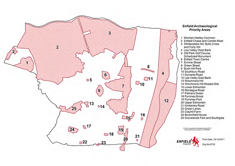
Map 15.2 Groundwater Flood Risk
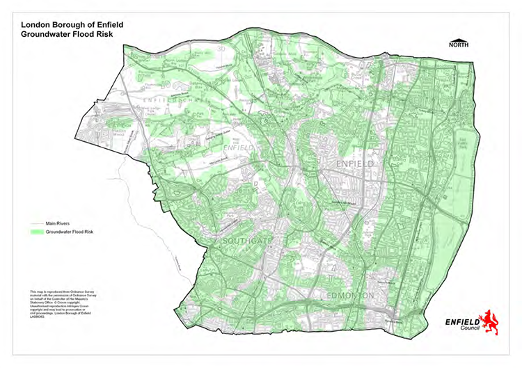
Map 15.3 Surface Water Flood Risk
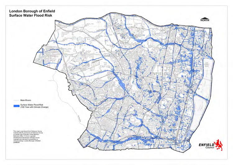
Map 15.4 Source Protection Zones
Map 15.5 Exsisting Tall Buildings
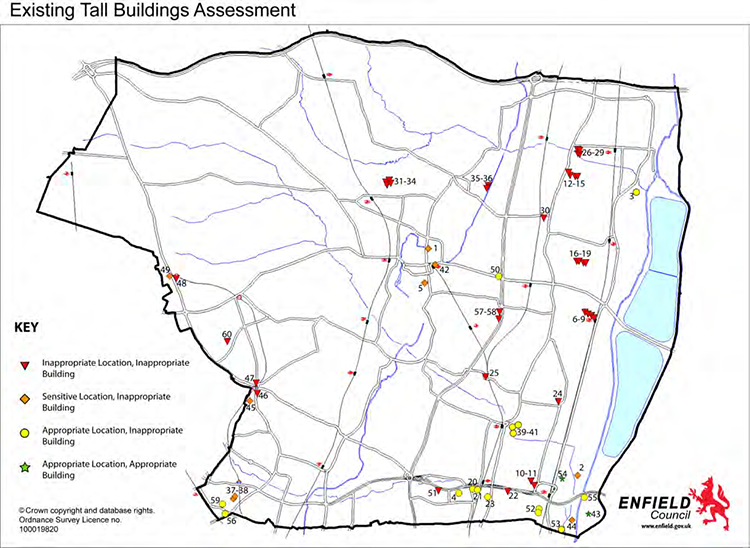
Tall Buildings Assessment Key
Table 15.1
|
|
Map 15.6 Important Views
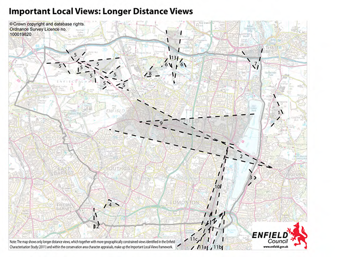
Table 15.2
1 Core Strategy preparation has been subject to an Equalities Impact Assessment
2 Addressed in section 4.1 Spatial Strategy of the Adopted Core Strategy.
3 Article 4 Directions are addressed in national policy.
4 General development considerations are addressed by national policy.
5 General development considerations are addressed by national policy.
6 General development considerations are addressed by national policy.
7 General development considerations are addressed by national policy.
8 The Mayor of London published the All London Green Grid SPG in March 2012 with a remit to promote the concept of green infrastructure,and increase its delivery by boroughs, developers, and communities, by describing and advocating an approach to the design and management of green and open spaces to deliver hitherto unrealised benefits. These benefits include sustainable travel, flood management, healthy living, and creating distinctive destinations; and the economic and social uplift these support.
9 Of the 12 Green Grid Areas, Enfield features in Green Grid Area 1 - Lea Valley and Finchley Ridge (GGA1). This together with the emerging Upper Lea Valley Opportunity Area Framework and the Upper Lea Valley Landscape Strategy provides a clear strategy as to how this should be improved and enhanced along with other pressures for development in each area.
10 Green Infrastructure relates to a network of multifunctional open spaces necessary to support social, economic and environmental benefits close to where people live and work. Open spaces include green spaces such as parks, allotments, commons, recreation grounds and playing fields; children’s play areas, woodlands, waterways and natural habitats and civic spaces such as squares.
11 adapted to the identified priorities of the Biodiversity Action Plan for Enfield. Validation requirements for applications may require the submission of an Ecological Report and/or Tree Survey, these documents would form the basis of this section as appropriate.
12 Mayor of London Wheelchair Accessible Housing Best Practice Guidance. GLA 2007; The Lifetime Homes Standards, www.lifetimehomes.org.uk