
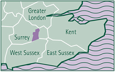
2.1 Mole Valley District lies at the heart of Surrey, mid-way between London and the Sussex coast. (Figure2.1).
Figure 2.1 Regional Context
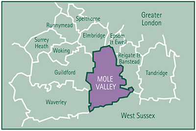
2.2 The District is bordered to the north by the boroughs of Elmbridge, Epsom and Ewell and the Royal Borough of Kingston upon Thames. To the west lie the Boroughs of Guildford and Waverley and to the east, the Borough of Reigate and Banstead. Crawley Borough and Horsham District, which lie in West Sussex, border the District's southern boundary. (Figure2.2).
Figure2.2 Surrey Context
2.3 Mole Valley is principally a rural district. It covers 258 square kilometres and has a resident population of approximately 79,000 people.
2.4 The District's two principal towns are Dorking and Leatherhead. Dorking (population 10,600) is situated in the centre of the District. It is a small historic market town surrounded by attractive countryside. Leatherhead lies in the north of the District. It has a slightly smaller population (9,700) than Dorking and provides a range of services to the local community. There are several industrial areas around the edge of the town containing a range of firms including those involved in high technology and research and development.
2.5 Fetcham (population 8,300) and Bookham (population 10,400) lie to the west of Leatherhead and Ashtead (population 13,400) to the east. These are principally residential areas that have grown up around original village centres.
2.6 The countryside of Mole Valley is extensive (accounting for 90% of the District's area) and contains a variety of attractive villages, hamlets and scattered isolated dwellings and farms. The landscape of the countryside is also highly attractive. The North Downs run across the centre of the District and include well known beauty spots such as Box Hill. The gently undulating Wealden landscape occupies much of the south of the District while the Greensand Ridge, including Leith Hill which is the highest point in South East England, crosses the south west of the District. The River Mole meanders north across the District from its source in Sussex and provides an attractive setting to Leatherhead and Dorking.
2.7 Three major roads pass through Mole Valley. They are the M25 motorway which has a junction at Leatherhead, the A24 London-Worthing Road and the A25 which follows the foot of the North Downs from the outskirts of Maidstone in Kent to the edge of Guildford. Two main railway lines, occupying the same corridors as the A24 and A25, provide rail services to London and Horsham, Reading, Redhill and Gatwick Airport. There is also a local service between Leatherhead and Guildford. (Figure 2.3).
Figure 2.3 Local Context
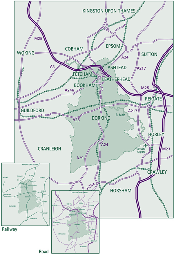
2.8 Gatwick Airport lies in the adjoining West Sussex borough of Crawley and abuts Mole Valley's south eastern boundary.
Figure 2.4 The Green Belt
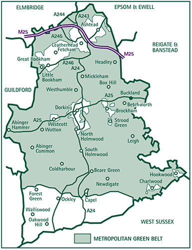
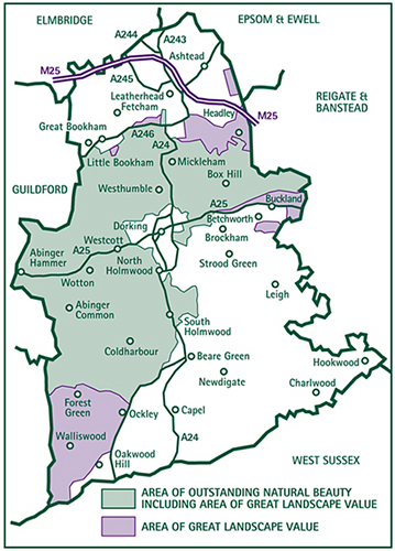
Figure 2.5 Area of Outstanding Natural Beauty and Area of Great Landscape Value
2.9 The District is already covered by several strategic environmental designations. The Green Belt boundary was established in the 1980's in the Dorking, Leatherhead and Rural Areas Local Plans and covers three quarters of the District. (Figure 2.4).
2.10 In recognition of the area's high landscape quality, one third of Mole Valley lies within the Surrey Hills Area of Outstanding Natural Beauty and the contiguous Area of Great Landscape Value extends over a further large area in the south west of the District. (Figure 2.5).
2.11 In addition to these areas of national and regional landscape importance, the District encompasses considerable areas of major ecological importance. There are twelve sites of Special Scientific Interest covering almost 9% of the District's area. In total, they account for nearly a quarter of the area of all SSSI's in Surrey. There are also seven nature reserves in the District.
2.12 Mole Valley's built heritage is also extensive and there are 28 Conservation Areas in the towns and villages and just under 1000 Listed Buildings which is a considerably higher number than the average for Surrey Districts. Of this total there are 6 Grade I and 44 Grade II* Listed Buildings. There are also 25 Scheduled Ancient Monuments in Mole Valley and 5 gardens on the Register of Parks and Gardens of Special Historic Interest in England which is compiled by English Heritage. There are many other parts of the built-up areas which have particular character and attraction which are greatly valued by those who live in them.
2.13 An important feature of Mole Valley is its location close to powerful economic generators - London on the northern boundary, Gatwick on the southern boundary and the Leatherhead interchange of the M25 motorway. Mole Valley has traditionally been an area of high market demand and the District experienced intense development pressures prior to the recession of the early nineteen nineties. Whilst planning controls have prevented the outward spread of the built-up areas of Dorking and Leatherhead, past development requirements imposed upon Mole Valley have resulted in more intensive development, particularly in the north of the District. This has been accentuated by modern development expectations.
2.14 It is anticipated that the District will continue to be subject to development pressures during the period covered by this Local Plan as a result of its locational attraction and a range of social and economic trends.
2.15 Although Mole Valley's population has increased by only about 5% during the last 20 years, the District has been one of the fastest growing areas in Surrey with an increase in housing stock of 24%, exceeded only by two other Districts in Surrey. Nearly all the additional dwellings were provided within the District's built-up areas which has resulted in the intensification of development in many of the established residential areas.
2.16 While it is expected that Mole Valley's population is likely to remain stable during the period covered by the Local Plan, the number of households is forecast to rise by 5.5%, principally as a result of the predicted increase in the number of single person households.
2.17 Nearly a quarter (21%) of the District's population is of pensionable age, which is the highest proportion for any District in Surrey. In contrast, 18% of the population is under the age of 16 which is the lowest proportion of any District. Most of the District's population (43%) are in the 30-60/65 age range.
2.18 New households experience difficulties in purchasing housing in Mole Valley, especially at the lower end of the market as a result of the relatively high house price structure of the area. The Council's waiting list provides a general indication of the number of households in the District seeking low cost or special housing. In April 2000 the List contained 1,080 households.
2.19 During the 1980s, economic activity in Mole Valley grew significantly. The number of firms in the District rose by 51% and the number of jobs increased by 32%. These significant increases were all the more remarkable since they resulted principally from the redevelopment, change of use or extensions to existing premises rather than by the development of major new 'greenfield' releases. They are a further reflection of the intensification of development which occurred in the District during the 1980's.
2.20 At the same time, the nature of employment changed. Manufacturing and traditional industrial jobs declined by 35% between 1981-1991 while professional and service related employment increased by 44% during the same period. In particular, there was a marked emergence of firms engaged in research and development and high technology/knowledge based industries, particularly in the Leatherhead area which has been recognised as a centre for research establishments. Dorking remains a more traditional service town.
2.21 In the rural areas of the District, agricultural and forestry are the most widespread uses of land and in 1993 provided employment for just under 800 people. Several farms have diversified into providing overnight accommodation, small industrial and business units, livery accommodation and other facilities to support farm incomes. In addition, a wide range of other economic activity takes place in the District's rural areas.
2.22 Historically, unemployment rates in Mole Valley have been well below national and regional averages.
2.23 Mole Valley, like other parts of Surrey experiences high levels of car ownership (nearly 50% higher than the national average) and high traffic flows overload parts of the road network, especially the built-up areas of Dorking and Leatherhead in peak times. This results in congestion, poor accessibility into the District's town centres and a deterioration of the local environment. In the countryside, especially in the south of the District, rural lanes also experience relatively high traffic flows. This is particularly so in the morning and evening peak hours as a result of commuting to major employment centres such as Crawley and Gatwick as well as northwards towards London.
2.24 Gatwick Airport lies just outside the District's south east boundary. The presence of the airport has had an impact on the District principally through disturbance from aircraft noise on the ground and in the air, increased traffic on rural roads in the south east of the District and the gradual expansion of the airport's activities on to land on the north side of the airport where it abuts Mole Valley. Heathrow Airport lies to the north west of Mole Valley. The northern part of the District is overflown by aircraft from Heathrow which create noise and disturbance to communities in this part of the District.
2.25 It is expected that during the period of this Local Plan, the airports will handle increasing numbers of flights and passengers. The previous Government decided to abandon the option of a second runway at Gatwick which had been set out in the RUCATSE report and was located entirely in Mole Valley. The Government commenced a study in 1999 on the issue of airport capacity in the South East and East of England as part of its commitments under the Transport White Paper. The Council is totally opposed to any additional runway at Gatwick.
2.26 An important part of the overall character of the towns of Leatherhead and Dorking is their shopping centres. Both centres are relatively small scale in County terms and principally serve their local communities and surrounding villages. They have to compete with off-centre shopping facilities particularly for the car borne shopper. But the town centres support other community facilities, along with certain shops not normally available in off-centre locations and essential shopping facilities for the less mobile. Their strengths also lie in their character and diversity of buildings. The viability and vitality of town centres, in the face of pressures for decentralisation, is therefore an important issue.
2.27 Ashtead, Fetcham and Bookham have their own local shopping centres which principally serve local needs and play an important role in the total pattern of retailing in the north of the District. Most of the larger villages in the District have small shops which provide a service for their local communities.
2.28 In the countryside, farming is undergoing change, particularly associated with reforms of the European agricultural policy. This is generating pressures for economic diversification and development particularly involving farm land and buildings. At the same time Government grants to farmers are now geared more towards environmental objectives rather than food production. These trends provide the challenge of achieving a viable future for the countryside but in a way which safeguards and, where possible, enhances the intrinsic rural character of this very attractive District.
2.29 Demand for open space is concentrated in the built-up areas and it is important that people, particularly children and the elderly, have access to open space close to where they live. Open spaces in the District's built-up areas, whether or not there is public access, make a significant contribution to the character and amenity of the locality which in turn contribute to the quality of life for the local community.
2.30 There is increasing public demand to use the countryside for recreation. The intrinsic natural beauty of Mole Valley make it an attractive location for visitors and local residents alike. In the areas around the District's towns and villages there is continuing pressure to use land for horse grazing which often gives rise to demand for related buildings and structures. There are demands for other informal country pursuits and more formal outdoor sporting facilities. These in turn may present opportunities for diversification of farms.
2.31 Mole Valley is predominantly a rural area containing extensive areas of countryside. There are few large scale industrial, commercial or agricultural operations which are potential sources of pollution. The principal source of air pollution is believed to be road transport using the M25 Motorway and the other major roads which run through the District. The Council carries out continuous monitoring for a number of pollutants including; oxides of nitrogen, ozone, sulphur dioxide, particles and volatile organic compounds (VOC's). The results are used to determine if the quality of air in the District is improving or deteriorating. The results have not revealed levels of pollution above national or international standards or guidelines.
2.32 The River Mole and the Tilling Bourne are the principal water courses in the District. The Mole rises to the south of Gatwick Airport and flows the length of the District from Hookwood in the south east, through Dorking and on to Leatherhead in the north. The Tilling Bourne rises to the north of Leith Hill and flows through Abinger Hammer before joining the River Wey at Guildford.
2.33 The River Mole Local Environment Agency Plan, which has been prepared by the Environment Agency, indicates that between 1997-1999, the river quality objectives for the length of the River Mole in the Mole Valley were complied with. It also indicates that a high quality coarse fishery exists below Brockham, all the way to the River Thames.
2.34 The water of the Tilling Bourne is of the highest quality in terms of its chemical content and ability to support all species of fish.
2.35 While no District wide noise surveys have been undertaken, the Council has extensive records of noise levels associated with the M25 Motorway in the Leatherhead area. The results of these surveys have indicated that the increasing volume of traffic on the M25 has led to a worsening of the noise climate. Aircraft noise is a source of considerable nuisance to the rural communities in the south of the District where there is a low ambient noise level. Monitoring of aircraft noise and track keeping is carried out by BAA Gatwick.
2.36 Overall, the picture of Mole Valley is one of high intrinsic environmental quality but where the pressures of development, traffic and other activity have been felt increasingly. It is not just the major schemes which have an impact, but also the collective effects of a whole range of small scale developments. The environmental characteristics of the District are a most valuable and irreplaceable resource, the importance of which provides the essential starting point for the strategy of this Local Plan for Mole Valley.
< Previous | ^ Top | Next >