Appendix 1: Superseded Policies Hastings Local Plan 2004 policies to be superseded
The following table explains how the existing policies of the Local Plan (2004) will be superseded by the Planning Strategy. In some places the detailed parts of the policies that relate to specific sites or aspects of potential planning applications will eventually be superseded by the emerging Development Management Plan (DMP) and details of this will be given along with that document at the appropriate time.
Local Plan 2004 page number |
Local Plan 2004 Chapter |
Local Plan 2004 Policy reference |
Local Plan 2004 Policy name |
How the policy will be superseded |
|---|---|---|---|---|
29 |
Employment |
E1 |
Sites for Employment Development |
Planning Strategy – DS2 (Employment
Growth) and E1 (Existing Employment Land and Premises) |
31 |
Employment |
E2 |
Industrial Development – Established
Estates |
Planning Strategy – E1 (Existing Employment Land and Premises) |
31 |
Employment |
E3 |
Ivyhouse Lane – Land at Burgess
Road |
Development Management Plan |
32 |
Employment |
E4 |
Retaining Employment Uses |
Planning Strategy – E1 (Existing
Employment Land and Premises) and E2 (Skills and Access to Jobs) |
32 |
Employment |
E5 |
Relocation of Non-Conforming Uses |
Planning Strategy – E1 (Existing
Employment Land and Premises) |
33 |
Employment |
E6 |
Small Industrial Firms |
Development Management Plan |
34 |
Employment |
E7 |
Class B1(a) Office |
Planning Strategy – DS2 |
34 |
Employment |
E8 |
Location of Business Uses |
Development Management Plan |
35 |
Employment |
E9 |
Locating Employment Sustainably |
Planning Strategy – SC1 (Overall
Strategy for Managing Change in a Sustainable Way) |
41 |
Tourism |
T1 |
New Tourist Attractions |
Planning Strategy – E4 (Tourism
and Visitors) |
41 |
Tourism |
T2 |
Amusements |
Planning Strategy – E4 (Tourism
and Visitors) |
42 |
Tourism |
T3 |
Hotels and Guest Houses– Serviced
Accommodation |
Planning Strategy – E4 (Tourism and Visitors) |
43 |
Tourism |
T4 |
Change of Use of Hotels and |
Planning Strategy – E4 (Tourism and Visitors) |
44 |
Tourism |
T6 |
Caravan and Camping Sites |
Planning Strategy – E4 (Tourism
and Visitors) |
44 |
Tourism |
T7 |
Development within Caravan Sites |
Planning Strategy – E4 (Tourism
and Visitors) |
45 |
Tourism |
T8 |
Language Schools |
Planning Strategy – E4 (Tourism and Visitors) |
45 |
Tourism |
T9 |
Retention of Language Schools |
Planning Strategy – E4 (Tourism and Visitors) |
47 |
Tourism |
T12 |
Enhancement of Hastings Pier |
Planning Strategy – E4 (Tourism and Visitors) |
53 |
Shopping |
S1 |
Town Centre Retail Proposals |
Planning Strategy – E3 (Town,
District and Local |
54 |
Shopping |
S2 |
District and Local Centres |
Planning Strategy – E3 (Town,
District and Local |
55 |
Shopping |
S3 |
Bohemia Road Core Shopping Area |
Planning Strategy – E3 (Town,
District and Local |
57 |
Shopping |
S4 |
Retail and Leisure Proposals Outside
Existing Centres |
Planning Strategy – E3 (Town, District and Local Centres) |
58 |
Shopping |
S5 |
Major Shopping Proposals Outside
Existing Centres |
Planning Strategy – E3 (Town,
District and Local |
64 |
Transport |
TR1 |
Road Improvements |
Planning Strategy – T1 (Strategic Road and Rail Schemes) and T2 (Local Road Improvements) |
66 |
Transport |
TR3 |
Station at Wilting |
Planning Strategy – T1 (Strategic Road and Rail Schemes) |
68 |
Transport |
TR4 |
South Coast Cycle Route |
Planning Strategy – T3 (Sustainable Transport) |
69 |
Transport |
TR5 |
Cycling Facilities in New |
Planning Strategy – T3 (Sustainable
Transport) |
69 |
Transport |
TR6 |
Location of New Development |
Planning Strategy - SC1 (Overall
Strategy for Managing Change in a Sustainable Way), T3 (Sustainable
Transport) and T4 (Travel Plans) |
70 |
Transport |
TR7 |
Accessibility |
Planning Strategy - SC1 (Overall
Strategy for Managing Change in a Sustainable Way), T3 (Sustainable
Transport) and T4 (Travel Plans) |
70 |
Transport |
TR8 |
Reduced Parking Provision in New
Development |
Planning Strategy – T3 (Sustainable
Transport) and T4 (Travel Plans) |
71 |
Transport |
TR9 |
Development Infrastructure |
Planning Strategy– CI1 (Infrastructure and Development Contributions) |
71 |
Transport |
TR10 |
Development in Un-Metalled Streets |
Development Management Plan |
82 |
Housing |
H1 |
Housing Sites |
Planning Strategy - DS1- New Housing
Development and FA1, FA2, FA3, FA4, FA5, FA6 - The focus area
policies set out the principles for the spread of new housing
sites and the numbers of new dwellings in each area |
85 |
Housing |
H2 |
Mixed Use Areas |
Planning Strategy - FA1, FA2, FA3,
FA4, FA5, FA6 - The focus area policies set out the principles
for the spread of new housing sites and the numbers of new dwellings
in each area |
87 |
Housing |
H4 |
Housing Conversions |
Development Management Plan |
89 |
Housing |
H6 |
Social Rented Housing |
Planning Strategy - H3 (Provision
of Affordable Housing) |
99 |
Community Needs |
CN1 |
Access for People with Disabilities |
Development Management Plan |
100 |
Community Needs |
CN3 |
Housing for Persons with Restricted
Mobility |
Development Management Plan |
102 |
Community Needs |
CN6 |
The University Centre |
Planning Strategy - E2 (Skills and Access to Jobs) |
103 |
Community Needs |
CN7 |
Premises for Early Years Education |
Development Management Plan |
105 |
Community Needs |
CN9 |
Nursing Homes, Rest Homes and Hostels |
Development Management Plan |
107 |
Community Needs |
CN12 |
Gypsies and Travelling Show People |
Planning Strategy - H5 (Accommodation for Travelling Communities) |
113 |
Nature Conservation |
NC1 |
Hastings Cliff Special Area of Conservation |
Planning Strategy - EN2 (Green Infrastructure Network) and EN3 (Nature Conservation and Improvement of Biodiversity) |
114 |
Nature Conservation |
NC2 |
Sites of Special Scientific Interest |
Planning Strategy - EN2 (Green Infrastructure Network) and EN3 (Nature Conservation and Improvement of Biodiversity) |
116 |
Nature Conservation |
NC3 |
Local Nature Reserves |
Planning Strategy - EN2 (Green Infrastructure Network) and EN3 (Nature Conservation and Improvement of Biodiversity) |
116 |
Nature Conservation |
NC4 |
Extension to Marline Valley Local
Nature Reserve |
Planning Strategy - EN2 (Green Infrastructure Network) and EN3 (Nature Conservation and Improvement of Biodiversity) |
117 |
Nature Conservation |
NC5 |
Local Nature Reserve Allocations |
Planning Strategy - EN2 (Green Infrastructure Network) and EN3 (Nature Conservation and Improvement of Biodiversity) |
119 |
Nature Conservation |
NC6 |
Sites of Nature Conservation Importance |
Planning Strategy - EN2 (Green Infrastructure Network) and EN3 (Nature Conservation and Improvement of Biodiversity) |
120 |
Nature Conservation |
NC7 |
The Green Network |
Planning Strategy - EN2 (Green Infrastructure
Network) |
122 |
Nature Conservation |
NC8 |
General Planning Requirements |
Development Management Plan |
124 |
Nature Conservation |
NC9 |
Information to Accompany Planning
Applications |
Development Management Plan |
125 |
Nature Conservation |
NC10 |
Ancient Woodland |
Planning Strategy - EN2 (Green Infrastructure Network) and EN3 (Nature Conservation and Improvement of Biodiversity) |
125 |
Nature Conservation |
NC11 |
Preserved Woodland |
Planning Strategy - EN2 (Green Infrastructure Network) and EN3 (Nature Conservation and Improvement of Biodiversity) |
126 |
Nature Conservation |
NC12 |
St Helens Wood - Protection |
Planning Strategy - EN2 (Green Infrastructure Network) and EN3 (Nature Conservation and Improvement of Biodiversity) |
129 |
Landscape |
L1 |
Landscape Character |
Planning Strategy - EN2 (Green Infrastructure Network) and EN4 (Conservation and Enhancement of Landscape) |
130 |
Landscape |
L2 |
High Weald Area of Outstanding Natural
Beauty |
Planning Strategy - EN2 (Green Infrastructure Network) and EN3 (Nature Conservation and Improvement of Biodiversity) and EN4 (Conservation and Enhancement of Landscape) |
131 |
Landscape |
L3 |
Development Outside the Built-Up
Area |
Planning Strategy - EN2 (Green Infrastructure
Network) and EN3 (Nature Conservation and Improvement of Biodiversity)
and EN4 (Conservation and Enhancement of Landscape) |
131 |
Landscape |
L4 |
Strategic Gap |
Planning Strategy - EN2 (Green Infrastructure Network) and EN4 (Conservation and Enhancement of Landscape) |
133 |
Landscape |
L6 |
Historic Parks and Gardens |
Planning Strategy - EN1 (Built and Historic Environment) |
134 |
LandscapeLandscape |
L7 |
The Undeveloped Coast |
Planning Strategy - EN2 (Green Infrastructure Network) and EN4 (Conservation and Enhancement of Landscape) |
138 |
Development Guidelines |
DG1 |
Development Form |
Planning Strategy - SC1, SC2, SC3,
SC4, SC5, SC6, SC7 - the sustainable community policies set out
the principles for development guidance |
139 |
Development Guidelines |
DG2 |
Access and Parking |
Planning Strategy - SC1 (Overall
Strategy for Managing Change in a Sustainable Way) and SC2 (Design
and Access Statements) |
139 |
Development Guidelines |
DG3 |
Sunlight and Daylight |
Planning Strategy - SC1, SC2 and
SC3 - the sustainable community policies set out the principles
for development guidance |
140 |
Development Guidelines |
DG4 |
Noisy Activities |
Planning Strategy - SC1 (Overall
Strategy for Managing Change in a Sustainable Way) |
140 |
Development Guidelines |
DG5 |
Noise Sensitive Development |
Planning Strategy - SC1 (Overall
Strategy for Managing Change in a Sustainable Way) and SC2 (Design
and Access Statements) |
141 |
Development Guidelines |
DG6 |
External Lighting |
Planning Strategy - SC1 (Overall
Strategy for Managing Change in a Sustainable Way) |
141 |
Development Guidelines |
DG7 |
High or Visually Prominent Buildings |
Planning Strategy - SC1 (Overall Strategy for Managing Change in a Sustainable Way) Development Management Plan |
142 |
Development Guidelines |
DG8 |
Protection of Views |
Planning Strategy - SC1 (Overall
Strategy for Managing Change in a Sustainable Way) |
143 |
Development Guidelines |
DG9 |
Traffic Calming |
Planning Strategy - SC1 (Overall
Strategy for Managing Change in a Sustainable Way) and SC2 (Design
and Access Statements) |
144 |
Development Guidelines |
DG11 |
Gardens |
Planning Strategy - SC1 (Overall
Strategy for Managing Change in a Sustainable Way) |
145 |
Development Guidelines |
DG12 |
Two Storey Side Extensions to Residential
Properties |
Planning Strategy - SC1 (Overall
Strategy for Managing Change in a Sustainable Way) and SC2 (Design
and Access Statements) |
146 |
Development Guidelines |
DG13 |
Provision of Children's Playspace |
Planning Strategy - CI3 (Children's Play Provision) |
146 |
Development Guidelines |
DG14 |
Shopfronts |
Planning Strategy - SC1 (Overall
Strategy for Managing Change in a Sustainable Way) |
146 |
Development Guidelines |
DG14 |
Shopfronts |
Planning Strategy - SC1 (Overall
Strategy for Managing Change in a Sustainable Way) |
147 |
Development Guidelines |
DG15 |
Security Shutters |
Planning Strategy - SC1 (Overall
Strategy for Managing Change in a Sustainable Way) |
148 |
Development Guidelines |
DG17 |
Licensed Premises |
Development Management Plan |
149 |
Development Guidelines |
DG18 |
Hot Food Take-Aways |
Development Management Plan |
149 |
Development Guidelines |
DG19 |
Commercial Development - Traffic |
Development Management Plan |
150 |
Development Guidelines |
DG20 |
Public Art |
Planning Strategy - SC1 (Overall
Strategy for Managing Change in a Sustainable Way) |
151 |
Development Guidelines |
DG21 |
Development on Unstable Land |
Planning Strategy - SC1, SC2 and
SC3 - the sustainable community policies set out the principles
for development guidance |
151 |
Development Guidelines |
DG22 |
Satellite Dishes |
Development Management Plan |
153 |
Development Guidelines |
DG23 |
Renewable Energy Schemes |
Planning Strategy - SC1, SC2, SC3, SC4, SC5, SC6, SC7 - the sustainable community policies set out the principles for development guidance |
154 |
Development Guidelines |
DG24 |
Energy Efficient Development |
Planning Strategy - SC1, SC2, SC3, SC4, SC5, SC6, SC7 - the sustainable community policies set out the principles for development guidance |
156 |
Development Guidelines |
DG25 |
Development Infrastructure |
Planning Strategy - CI1 (Infrastructure and developer Contributions) |
158 |
Development Guidelines |
DG26 |
Flood Risk |
Planning Strategy - SC7 (Flood Risk) |
159 |
Development Guidelines |
DG27 |
Surface Water |
Planning Strategy - SC7 (Flood Risk) |
160 |
Development Guidelines |
DG28 |
Telecommunications Installations |
Planning Strategy - SC1 (Overall
Strategy for Managing Change in a Sustainable Way) |
160 |
Development Guidelines |
DG29 |
High Pressure Gas Main |
Planning Strategy - SC1 (Overall
Strategy for Managing Change in a Sustainable Way) |
161 |
Development Guidelines |
DG30 |
Overhead Power Lines - Safety |
Planning Strategy - SC1 (Overall
Strategy for Managing Change in a Sustainable Way) |
161 |
Development Guidelines |
DG31 |
New Overhead Power Lines |
Planning Strategy - SC1 (Overall
Strategy for Managing Change in a Sustainable Way) |
162 |
Development Guidelines |
DG33 |
Environmental Pollution |
Planning Strategy - SC1 (Overall
Strategy for Managing Change in a Sustainable Way) |
163 |
Development Guidelines |
DG34 |
Contaminated Land |
Planning Strategy - SC1 (Overall
Strategy for Managing Change in a Sustainable Way) |
171 |
Historic Environment |
C1 |
Development within Conservation Areas |
Planning Strategy - EN1 (Built and
Historic Environment) outlines the principles for development
in these areas |
173 |
Historic Environment |
C2 |
Demolition in a Conservation Area |
Planning Strategy - EN1 (Built and
Historic Environment) outlines the principles for development
in these areas |
174 |
Historic Environment |
C3 |
Development Involving Listed Buildings |
Planning Strategy - EN1 (Built and
Historic Environment) outlines the principles for development
affecting these buildings |
175 |
Historic Environment |
C4 |
Demolition of Listed Buildings |
Planning Strategy - EN1 (Built and
Historic Environment) outlines the principles for development
affecting these buildings |
175 |
Historic Environment |
C5 |
Winch Huts |
Planning Strategy - EN1 (Built and
Historic Environment) outlines the principles for development
for these buildings |
176 |
Historic Environment |
C6 |
Archaeological Sites and Ancient
Monuments |
Planning Strategy - EN1 (Built and Historic Environment) outlines the principles for development in these areas, or affecting these structures |
177 |
Historic Environment |
C7 |
Replacement Doors and Windows in
Listed Buildings |
Planning Strategy - EN1 (Built and
Historic Environment) outlines the principles for development
in these areas |
177 |
Historic Environment |
C8 |
Replacement Doors and Windows in
Conservation Areas |
Planning Strategy - EN1 (Built and
Historic Environment) outlines the principles for development
in these areas |
178 |
Historic Environment |
C9 |
Roof Materials for Listed Buildings |
Planning Strategy - EN1 (Built and
Historic Environment) outlines the principles for development
for these buildings |
178 |
Historic Environment |
C10 |
Roof Materials for Conservation Areas |
Planning Strategy - EN1 (Built and
Historic Environment) outlines the principles for development
in these areas |
186 |
Sports and Recreation |
SP1 |
Playing Fields and Sports Pitches |
Planning Strategy - EN5 (Open Spaces;
Enhancement, Provision and Protection); CI2 (Sports and Leisure
Facilities) and CI3 (Children's Play Provision) |
186 |
Sports and Recreation |
SP2 |
Sports and Recreational Facilities |
Planning Strategy - EN5 (Open Spaces;
Enhancement, Provision and Protection); CI2 (Sports and Leisure
Facilities) and CI3 (Children's Play Provision) |
187 |
Sports and Recreation |
SP3 |
Location of Major New Sports and
Recreational Facilities |
Planning Strategy - EN5 (Open Spaces;
Enhancement, Provision and Protection); CI2 (Sports and Leisure
Facilities) and CI3 (Children's Play Provision) |
187 |
Sports and Recreation |
SP4 |
White Rock Area |
Planning Strategy - EN5 (Open Spaces;
Enhancement, Provision and Protection); CI2 (Sports and Leisure
Facilities) and CI3 (Children's Play Provision) |
193 |
Open Space |
OS1 |
Protection of Open Space |
Planning Strategy - EN5 (Open Spaces;
Enhancement, Provision and Protection); CI2 (Sports and Leisure
Facilities) and CI3 (Children's Play Provision) |
194 |
Open Space |
OS2 |
Areas Deficient in Open Space |
Planning Strategy - EN5 (Open Spaces;
Enhancement, Provision and Protection); CI2 (Sports and Leisure
Facilities) and CI3 (Children's Play Provision) |
194 |
Open Space |
OS3 |
Private Open Space |
Planning Strategy - EN5 (Open Spaces;
Enhancement, Provision and Protection); CI2 (Sports and Leisure
Facilities) and CI3 (Children's Play Provision) |
195 |
Open Space |
OS4 |
Allotments |
Planning Strategy - EN5 (Open Spaces |
195 |
Open Space |
OS5 |
Amenity Footpath Network |
Planning Strategy - EN5 (Open Spaces;
Enhancement, Provision and Protection); CI2 (Sports and Leisure
Facilities) and CI3 (Children's Play Provision) |
200 |
Hastings Town Centre |
TC1 |
Hastings Station Yard |
Planning Strategy - FA3 (Strategic
Policy for Hastings Town Centre) |
201 |
Hastings Town Centre |
TC3 |
Queens Road Conversions |
Planning Strategy - FA3 (Strategic
Policy for Hastings Town Centre) |
202 |
Hastings Town Centre |
TC4 |
Site of Sussex Chambers |
Planning Strategy - FA3 (Strategic Policy for Hastings Town Centre) |
202 |
Hastings Town Centre |
TC5 |
The Observer Building |
Planning Strategy - FA3 (Strategic
Policy for Hastings Town Centre) |
204 |
Hastings Town Centre |
TC7 |
Greenway |
Planning Strategy - FA3 (Strategic
Policy for Hastings Town Centre) |
205 |
Hastings Town Centre |
TC8 |
Memorial Replacement |
Planning Strategy - FA3 (Strategic
Policy for Hastings Town Centre |
211 |
Central St Leonards |
SL1 |
Taxi Office/BR Social Club Site |
Planning Strategy - FA4 (Strategic
Policy for Central St Leonards) |
212 |
Central St Leonards |
SL2 |
Problem Buildings |
Planning Strategy - FA4 (Policy for
Central St Leonards) |
212 |
Central St Leonards |
SL3 |
Western Road/Cross Street Area |
Planning Strategy - FA4 (Strategic
Policy for Central St Leonards) |
224 |
West St Leonards |
WSL1 |
Land at Seaside Road– Developments |
Planning Strategy - FA1 (Strategic
Policy for Western Area) |
225 |
West St Leonards |
WSL2 |
Land at Seaside Road – Seafront
Walk/Cycle Path |
Planning Strategy - FA1 (Strategic
Policy for Western Area) |
226 |
West St Leonards |
WSL3 |
Land at Bexhill Road– Development |
Planning Strategy - FA1 (Strategic
Policy for the Western Area) |
231 |
Broomgrove |
B1 |
Broomgrove Regeneration |
Planning Strategy - FA5 (Strategic
Policy for the Eastern Area) |
233 |
Broomgrove |
B3 |
Facilities at Ore Station |
Planning Strategy - FA5 (Strategic
Policy for Eastern Area) |
233 |
Broomgrove |
B4 |
Local Park |
Planning Strategy - FA5 (Strategic
Policy for Eastern Area) |
235 |
Broomgrove |
B5 |
Broomgrove – Highway Improvements/
Traffic Management |
Planning Strategy - FA5 (Strategic Policy for Eastern Area) Development Management Plan |
235 |
Broomgrove |
B6 |
The Former Stills Factory Site, Fellows
Road |
Planning Strategy - FA5 (Strategic
Policy for Eastern Area) |
240 |
Holmhurst St Mary |
HSM1 |
Holmhurst St Mary – |
Planning Strategy - FA1 (Strategic
Policy for Western Area) |
242 |
Holmhurst St Mary |
HSM2 |
Holmhurst St Mary – Highway
Access |
Planning Strategy - FA1 (Strategic
Policy for |
246 |
Seafront Strategy |
SS1 |
The Stade Maritime Heritage Area |
Planning Strategy - FA6 (Strategic
Policy for the Seafront) |
247 |
Seafront Strategy |
SS2 |
The Stade/Old Town Seafront |
Planning Strategy - FA6 (Strategic
Policy for the Seafront) |
Hastings Local Plan 2004 - Expired Policies
As from 27th September 2007, a number of policies in the Hastings Local Plan 2004 expired and are therefore have not since been used in consideration of planning applications.
These policies were no longer required as in some cases they duplicated other Local Plan policies or National Planning Policy and in other cases the development they referred to has been completed.
Expired policies included:
- B2 - Broomgrove Housing Sites
- CN2 - Parking for People With Disabilities
- CN4 - Hastings College
- CN5 - Hastings College - Relocation
- CN8 - Community FacilitiesCN8 - Community Facilities
- CN10 - Library Facilities
- CN11 - Hastings Museum and Art Gallery
- DG10 - Retention of Car Parking
- DG32 - Development Adjoining Railways
- H3 - Lower Density Areas
- H5 - Change of Use
- L5 - Farm Diversification
- OT1 - Old Town Protection Area
- S6 - Land Allocated for Non-Retail Uses
- SP5 - Football - Pilot Field
- T10 - Conference Facilities
- T11 - Water Based Recreation
- T5 - Self-Catering Accommodation
- TC2 - The Queens Hotel
- TC6 - The BT Building, Havelock Road
- TR2 - Defined Road Hierarchy
Appendix 2: Hastings Borough Council Housing Trajectory 2011-2028
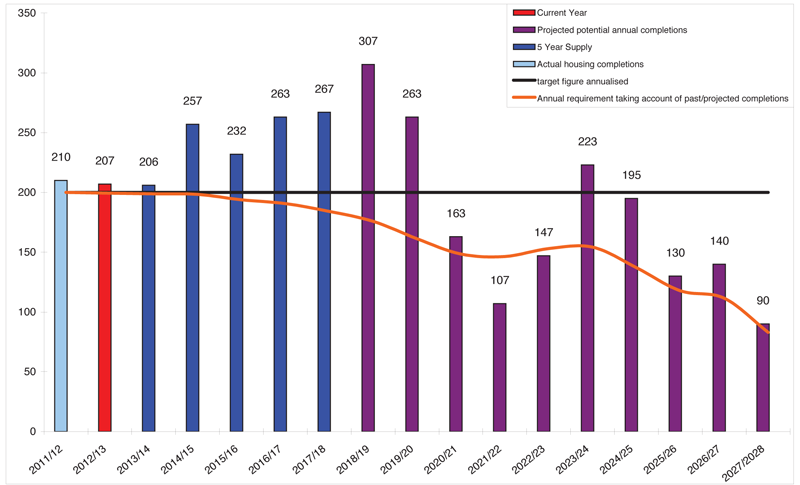
Figure 12: Housing trajectory graph
Housing Trajectory
The housing trajectory 2011 to 2028 shows past annual dwelling completions and projected annual completions in Hastings against a housing requirement of 3,400 dwellings. It examines, on an annual basis, how many additional dwellings will be needed at any one point in time to meet the housing requirements remaining over the period of the Plan. The current trajectory represents the housing land supply position as at 1 April 2012.
The forward looking element of the graph, takes account of the potential supply of housing arising from sites where construction activity is on-going, those with a current planning permission, sites that are allocated in the adopted Hastings Local Plan 2004 and unallocated sites that have the potential to contribute to housing delivery.
The data that underpins the trajectory is based on the Strategic housing Land Availability Assessment, and also reflects the latest information gathered from housing developers and land owners regarding build rates and disposal plans.
The trajectory will be updated annually in the Council's Annual Monitoring Report.
Local Planning Authorities (LPAs) have to ensure they have a continuous five year supply of deliverable sites available for housing development. National guidance requires that the 5-year supply should include an additional allowance of plus 20%. The five year period starts after the current monitoring year, 2012/2013, and should include the net additional dwellings expected to come forward from ready to develop sites.
Critically, in order for sites to be considered deliverable and included in the 5 year supply, sites should be:
- Available - the site is available for development now
- Suitable - the site offers a suitable location for development and would contribute to the creation of sustainable, mixed communities
- Achievable - there is a reasonable prospect that housing will be delivered on the site within 5 years
In compiling 5-year supply figure, all sites have been assessed against
these three factors.
The table below shows how the 5-year supply is calculated
Housing Target |
3,400 |
|---|---|
Residual target (after deducting 417 completions in 2011/12 & 2012/13) |
2,983 |
Annual residual target (residual divided by 15 years 2013/14 – 2027/28 |
199 |
5-year target (annual residual x 5 years + 20%) |
1,194 |
5-year housing land supply 2012/13 – 2016/17 |
1,225 |
5-year supply of housing expressed as a % |
102.6% |
Number of years of housing land supply |
6.2 |
Table 10: Calculating 5-year housing land supply
The current assessment of sites shows that in terms of a five year supply, there is the potential for some 1,323 dwellings to come forward in this period. This is in excess of the target number 1,225 and is equivalent to 6.2 years of supply.
< Previous | ^ Top | Next >